All Activity
- Past hour
-

July 2025 Obs/Disco ... possible historic month for heat
Baroclinic Zone replied to Typhoon Tip's topic in New England
Low of 68 here, has already rebounded to 76. -

July 2025 Discussion-OBS - seasonable summer variability
bluewave replied to wdrag's topic in New York City Metro
The sea breeze fronts will probably be the focus for convection along with the remnant moisture from Chantal. Some areas might not see much rain next few days. While others could get a quick 2-3”+. Kind of like Florida where you can drive a few miles between sunny and thunderstorms.
-

July 2025 Obs/Disco ... possible historic month for heat
dendrite replied to Typhoon Tip's topic in New England
Min 67.3° Should be high 80s here again with more low 90s in the warm spots. -
Difficult day for LWX and their forecasts.
-
2011-2012 was awful.
-

2025-2026 ENSO
40/70 Benchmark replied to 40/70 Benchmark's topic in Weather Forecasting and Discussion
Probably doesn't go out any further? -
2025-2026 ENSO
40/70 Benchmark replied to 40/70 Benchmark's topic in Weather Forecasting and Discussion
That looks more like the other guidance with the heat bottled up in the southern planes IVO Texas....more -EPO like. I buy that. -
There wasn’t even the slightest bit of seriousness in my post. Clearly a joke
-

July 2025 Obs/Disco ... possible historic month for heat
kdxken replied to Typhoon Tip's topic in New England
73/69 yuck -
July 2025 Obs/Disco ... possible historic month for heat
kdxken replied to Typhoon Tip's topic in New England
Good to know - Today
-
Dammit it's raining again. The radar is getting busy again. There goes my precious 95 degree day! I sure hope we aren't the ones who get stuck with ten more inches!
-
It’s getting HOT and STEAMY in here.
-

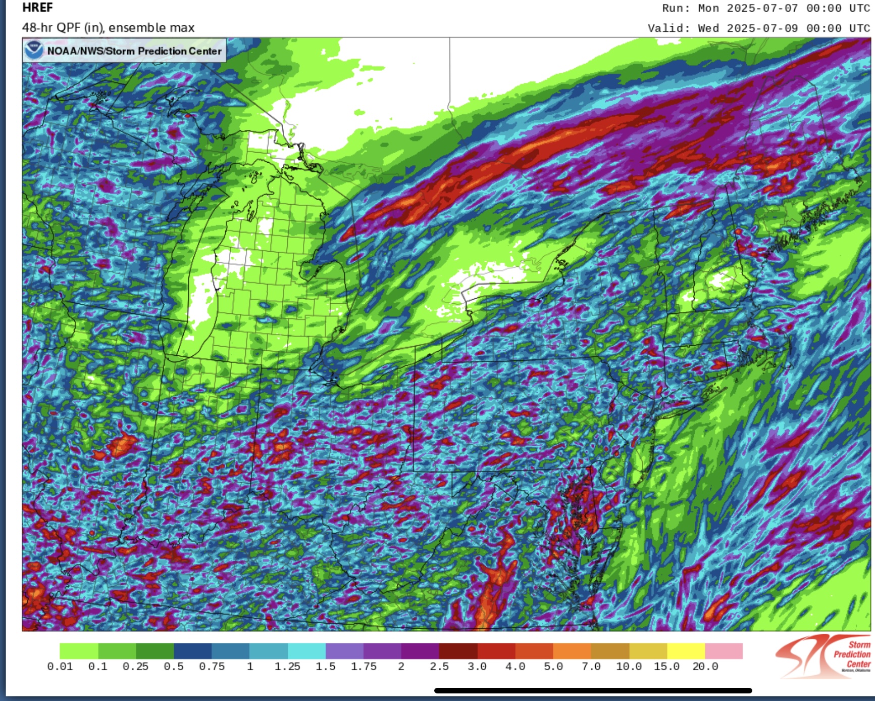
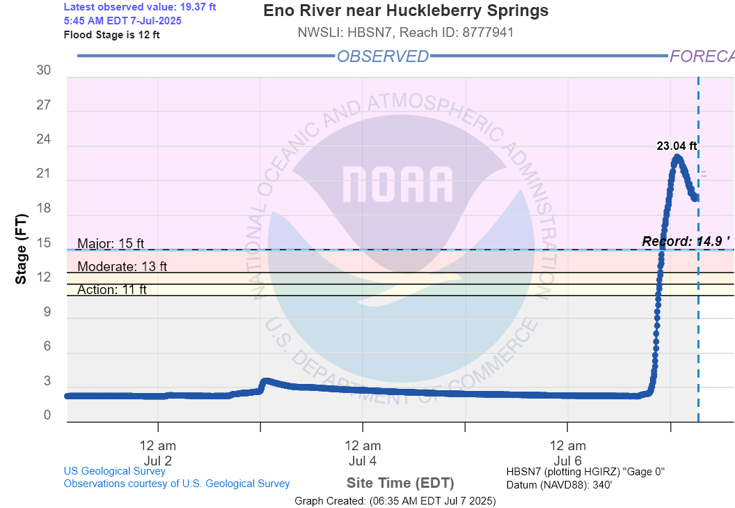
Texas 2025 Discussion/Observations
Stx_Thunder replied to Stx_Thunder's topic in Central/Western States
It's just a total shame that a lot of people still don't heed flash flood warnings as they should like with tornado warnings. Especially when in a low-lying area or near a river as both are the case with the ongoing Kerrville area flood deaths. And it's not like this has never happened before in the state in recent years. I honestly thought that after what happened in Wimberley area back in spring 2015 & 2017's Hurricane Harvey remnant Low stalled for days in SETX, people around the state would've at least learned to be a bit more mindful of what flooding and 'excessive rainfall' actually is. Especially anything that's tropical, as the culprit of the Kerrville area flooding was also a remnant Low of what was TS Barry that made landfall in Mex from the SW Gulf last weekend (NWS Austin/San Antonio office mentioned this in AFD earlier last week). I've been seeing the remnant Low or MCV spinning on radar around the Kerrville area over the past couple days. Even an Accuweather meteorologist pointed out twice on air that FF warnings were issued by NWS, several hours before the flood waters even escalated in the county into July 4th. So I definitely think more than 50% of whatever the death toll ultimately is in the coming days, could have easily been prevented. -
Ratio of “thunderstorm chances” in the forecast to anything of note actually happening has been abysmal for a long time now here. Desperately need a Wisconsin MCS charging across the lake. Any time now. This afternoon popup garbage avoids GRR every single time. Trash climatology getting worse.
-
They need to just replace the mt holly radar at this point
-
OK folks. We actually sighted the Sun today. We ALMOST hit 90. Hardly any rain, getting all excited about Monday, SUN WITH EGYPT-LIKE SUMMER CONDITIONS! Man I'll go out and jebwalk, pretend to be looking for hieroglyphic inscriptions at Amarna! I was SOOOOOOOOOOOOOOOOOOOOOOOOOOOOO STOKED! Then my heart was shattered by the latest from NWS. Flood Watch National Weather Service Austin/San Antonio TX 1146 PM CDT Sun Jul 6 2025 TXZ171>173-184>194-203>208-071800- /O.NEW.KEWX.FA.A.0005.250707T0446Z-250708T0000Z/ /00000.0.ER.000000T0000Z.000000T0000Z.000000T0000Z.OO/ Llano-Burnet-Williamson-Edwards-Real-Kerr-Bandera-Gillespie- Kendall-Blanco-Hays-Travis-Bastrop-Lee-Uvalde-Medina-Bexar-Comal- Guadalupe-Caldwell- Including the cities of Llano, Fredericksburg, Bastrop, Uvalde, Blanco, Georgetown, Lockhart, Bandera, Austin, Rocksprings, San Antonio, Boerne, Hondo, New Braunfels, Seguin, Leakey, Kerrville, San Marcos, Giddings, and Burnet 1146 PM CDT Sun Jul 6 2025 ...FLOOD WATCH IN EFFECT THROUGH MONDAY EVENING... * WHAT...Flooding caused by excessive rainfall is possible. Local rainfall amounts of 2 to 4 inches with 10 inches possible. * WHERE...A portion of south central Texas, including the following counties, Bandera, Bastrop, Bexar, Blanco, Burnet, Caldwell, Comal, Edwards, Gillespie, Guadalupe, Hays, Kendall, Kerr, Lee, Llano, Medina, Real, Travis, Uvalde and Williamson. * WHEN...Through 7 PM CDT Monday evening. * IMPACTS...Excessive runoff may result in flooding of rivers, creeks, streams, and other low-lying and flood-prone locations. * ADDITIONAL DETAILS... - A moist tropical airmass combined with a slow moving storm system will bring another round of scattered to numerous showers and storms overnight into Monday morning with heavy rain rates possible. - http://www.weather.gov/safety/flood PRECAUTIONARY/PREPAREDNESS ACTIONS... You should monitor later forecasts and be alert for possible Flood Warnings. Those living in areas prone to flooding should be prepared to take action should flooding develop. && $$ CP This broken record of an Energizer Bunny forecast is starting to read like a George BM forecast! This, is definitely NOT enjoyable. We are stuck in this nightmarish RUT, with no way out. ARE YOU KIDDIN' ME? The radar returns are evaporating! Drier air is advecting in right now at the mid levels! I was all excited about pretending to be Indiana Jones' Dad looking for the Holy Grail in old Egypt! This weather system is like a damned BROKEN RECORD! It just keeps on going, and going, and going! I can't BELIEVE this shoosh! The moisture is GONE! There is NO MORE LIFT! Someone at the National Weather Service is obsessed with this damned storm! GET OVER THIS ALREADY! It's high time to forecast 900dm upper ridge over Buda, for the next nine months, La Nina in place with highs in the lower to middle 110s, NO RAIN AT ALL and blistering Egypt-like sun blasting Amarna Buda with fiery heat! I'll be out there dusting off relics and pretending I am archeologisting in the hot countryside at Amarna!
-

July 2025 Obs/Disco ... possible historic month for heat
bristolri_wx replied to Typhoon Tip's topic in New England
You do realize that NOAA/NWS has always had geographic differences for criteria of advisories, watches and warnings of all different types? There are differing criteria for cold temperatures, frost/freeze, snow, etc as well. Here you are 100% correct in stating facts about temps in those other locations yet 100% wrong in your assessment as to why they did not receive advisories and we did... EDIT: Looks like several others have also brought up this point. -
I play there when I'm up in York, I like the course. It is hard.
-

July 2025 Obs/Disco ... possible historic month for heat
Typhoon Tip replied to Typhoon Tip's topic in New England
https://www.instagram.com/p/DLUx33htNZZ/?igsh=MTl4ZGNqbHV4NGsxbw== -
juicy
-
It's the worst weather disaster we've had in MANY years, flooding can be really deadly. Sometimes I wish that they would just dam up rivers that are prone to this kind of flooding.
-

July 2025 Discussion-OBS - seasonable summer variability
LibertyBell replied to wdrag's topic in New York City Metro
Looks like Tuesday might be our next shot at widespread 90 degrees, Tony?? -
July 2025 Discussion-OBS - seasonable summer variability
LibertyBell replied to wdrag's topic in New York City Metro
wow that sounds much like our March 2010 noreaster when we had 80 mph winds!! -
July 2025 Discussion-OBS - seasonable summer variability
LibertyBell replied to wdrag's topic in New York City Metro
Do you think it will be like last Thursday was??