All Activity
- Past hour
-
 Cook the bird Wednesday
 -
December 2025 Short/Medium Range Forecast Thread
Kentucky replied to John1122's topic in Tennessee Valley
Hopefully, copied the URL off Chris Bailey's latest blog post. Then just clicked on other media and add image URL here https://kyweathercenter.com/?p=73876 -

2025-2026 ENSO
donsutherland1 replied to 40/70 Benchmark's topic in Weather Forecasting and Discussion
That’s true. Unfortunately, there’s no daily TNH index to quantify things. -
There are some fall and winter blooming cultivars
-
You have good luck... start it
-

December 2025 Short/Medium Range Forecast Thread
Carvers Gap replied to John1122's topic in Tennessee Valley
I think that trough is baked in the cake. It should be COLD. Nice animation. How did you get the GIF for WxBell to work? -
Anything pertaining to December really should be in the winter thread, as that is the official beginning of Met winter, and this thread is specifically for November. Maybe time to start a thread for December?
-
December 2025 Short/Medium Range Forecast Thread
Carvers Gap replied to John1122's topic in Tennessee Valley
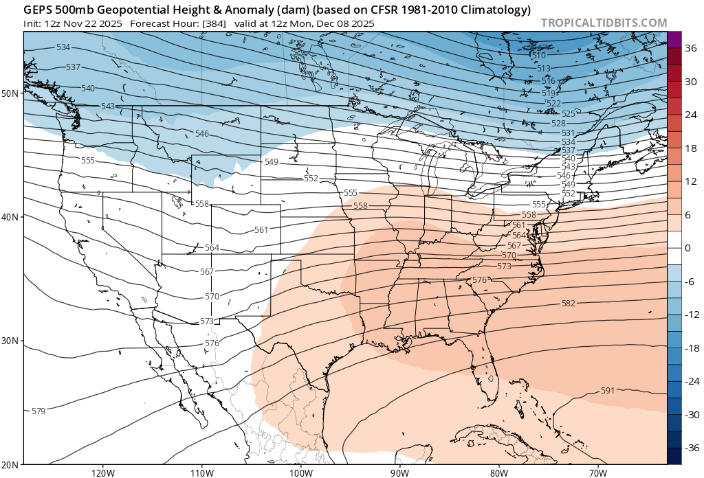
These are the changes for week 3 of December. Ridge is out of the Aleutians. There is no ridge bellying into the SE. This would allow for northern stream systems and sliders. The control is MUCH colder than this. -
December 2025 Short/Medium Range Forecast Thread
Kentucky replied to John1122's topic in Tennessee Valley
I'm looking for anything right now, and then 12z Euro AI delivered a deep trough. -

November 2025 general discussions and probable topic derailings ...
WinterWolf replied to Typhoon Tip's topic in New England
Oh boy here we go lol…f the winds…it’s a joke. -

November 2025 general discussions and probable topic derailings ...
ORH_wxman replied to Typhoon Tip's topic in New England
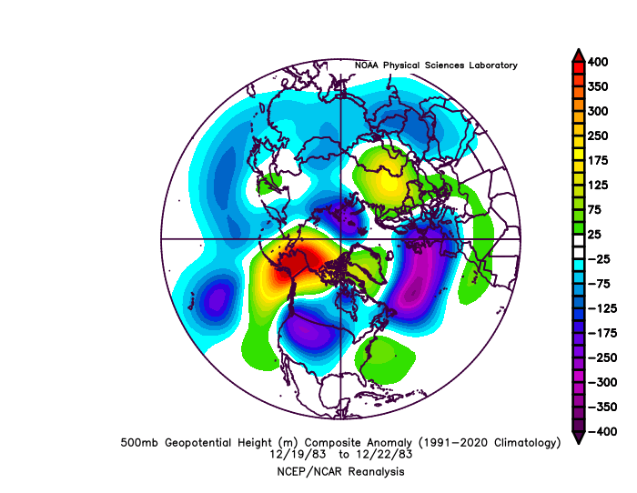
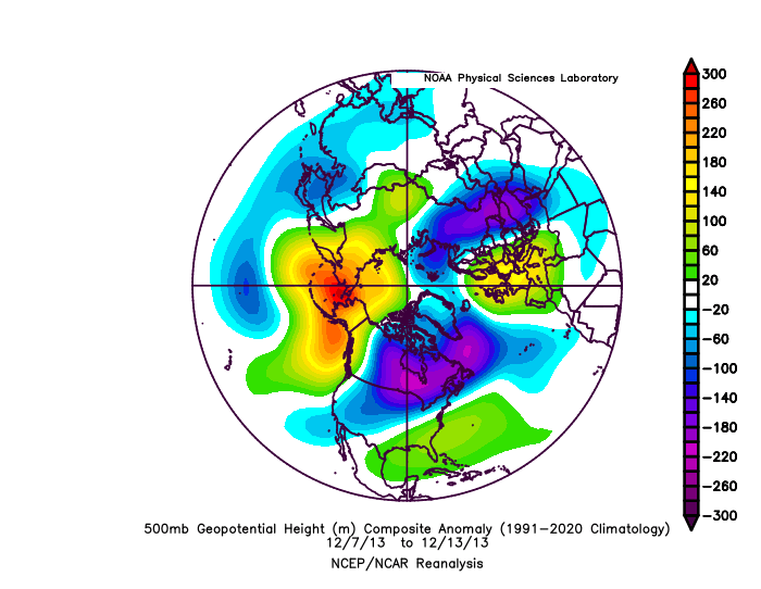
2008 also had a similar SE ridge (this is the setup for the prolific back to back snow events that month pre-Xmas)…the key to keeping it cold in New England is the big SE Canada vortex. If you don’t have that, you can’t hold that high/confluence long enough. Here’s prior to the 12/22/83 SWFE as well. Big massive cold dump into the plains and Rockies with decent SE ridge but we had some good antecedent cold held in by that confluence in SE Canada..little mini NAO on the ‘83 look but it’s the same idea/concept…anything to hold confluence over SE Canada. Here’s the back to back SFWE setup in December 2013 as well…look at that SE Canada region…huge -WPO/-EPO fighting that SE ridge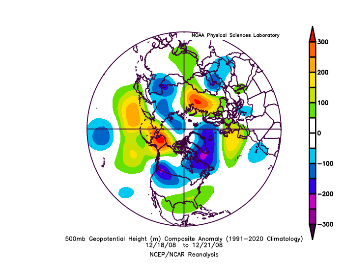
-

Fall 2025 Medium/Long Range Discussion
Spartman replied to Chicago Storm's topic in Lakes/Ohio Valley
Which was followed by a cool summer that same following year. -
People put too much emphasis on the AO/NAO/SPV stuff. You can have a +TNH/Hudon vortex anchored in place all winter coupled with an SPV on roids. This was mostly the case in 13-14/14-15. Then again I am biased towards the great lakes, but I like seeing the indo-pacific warm pool and the -EPO pattern show up.
-
December 2025 Short/Medium Range Forecast Thread
Carvers Gap replied to John1122's topic in Tennessee Valley
Comparing week 2 of December. This is the change which is seen on the Euro Weeklies. This was derived from the 0z run. The 12z derivation would have certainly been even better. Notice the SER is gone. Notice the EPO ridge? It isn't in the Aleutians which teleconnects to AN heights over the SE. That is a 1,000mi change in the Eastern Pac ridge. There are AN heights over Greenland. Those changes IMHO are a direct result of things resolving w/ the erroneous(?) Baja low. The SER doesn't get pumped long term. addendum: Yesterday, the blues and yellows were exactly where u didn't want them. Today, they are generally where you want them -
Wind advisory or perhaps HWW on Tgiving Day with strong CAA and mixing .
-
^12z GEFS looks a bit colder for around the 7th. Realistically expectations should be low for snow at that juncture, outside of first flakes in the air kind if thing. Turning colder, yes.
-
What happened? We went from December-to-remember to canceling winter in 12hrs, best I can tell. This is JB level capitulation.
-

November 2025 general discussions and probable topic derailings ...
dendrite replied to Typhoon Tip's topic in New England
Cold wetbulbs right off the deck. -
If only the weeklies were correct for once in the super long range. Nice look mid to late December.
-

November 2025 general discussions and probable topic derailings ...
eduggs replied to Typhoon Tip's topic in New England
This says "cold rain" to me outside of the elevated interior. Except maybe if you could squeeze a SWFE in there somewhere. That's not really unseasonable though. And I prefer the GEFS and EPS anyway.
-
Somebody mentioned this earlier... Was driving home from Annapolis this afternoon and noticed a Japanese cherry that was about half in bloom. Wonder why, not like it's been warm out or anything this fall. Weird.
-
We received 0'" at our location (Bellvue NW of Fort Collins). Thought we'd at least get something MEASURABLE but nada. So still no precip. in Nov. and 40+ days since any was recorded. Brutal...
-
December 2025 Short/Medium Range Forecast Thread
Carvers Gap replied to John1122's topic in Tennessee Valley
Noticeable shift colder today on most models with the exception of the CMC deterministic. The Euro Weeklies have returned to their cold look and serviceable 500 pattern for December. By the second week of December, they begin to push the cold for the rest of that month - equilibrium restored. The Weeklies, contrary to some comments on other forums, had a major change about two days ago. That first week of December has pretty much been warm on those Weeklies for some time. Nobody is upset about that. The thing that was frustrating to see was the Weeklies completely lost the rest of the month of December, especially after nearly 4-5 weeks of cold being shown. The Euro Weeklies have been anything but steady this past week - welcome to shoulder season. I really think the problem was feed back over the Southwest. Now that is being resolved with each passing run, modeling(deterministic and ensembles) is beginning to correlate again with the MJO and LR ext modeling. -
There would definitely be a lot of chaotic NS activity with that look, but should a wave take the southern route we could be in a good spot. Verbatim temps are marginal for us. Maybe a few days later would be better. Overall that same look a month later would be more favorable for the MA.
-
November 2025 general discussions and probable topic derailings ...
eduggs replied to Typhoon Tip's topic in New England
Maybe. The details will/would determine the regional outcome across the sharp gradient I guess. In my experience a ridge through LA, MS, AL, GA, TN, KY usually doesn't work out well except in NNE. To me this looks like a recipe for big snows across maybe the high plains, upper mid-west, or southern Canada. Not much sense in dissecting a 15-day ensemble mean though I guess. At least we're into winter-type "patterns."