All Activity
- Past hour
-

November 2025 general discussions and probable topic derailings ...
WinterWolf replied to Typhoon Tip's topic in New England
Yes sir…stepping down steadily as Jerry said. -
ICON has it for Central Va, UKIE has it for NE MD. Think it could be real… would just like first flakes without needing to drive to Snowshoe
-
Yeah I think the Ukie as well recently have been completely inaccurate. I'm cool with some snow, which at least looks likely with some mood flakes this weekend.
-
GGEM has that upper low thing as well, but farther south so brings the "snow" through NC and southern VA. On a different note, all the 12z ops have completely punted any real warmup for mid-month. Have to see if ensembles agree.
-
that model has been shitting out huge LES events on our side of the lake for two or three years now, none of which have verified euro and others showing some accumulating snow in and around the area tho so decent chance we see some flakes out of this to kick off the season
-
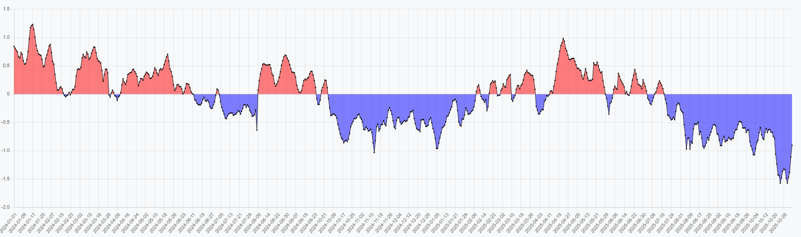
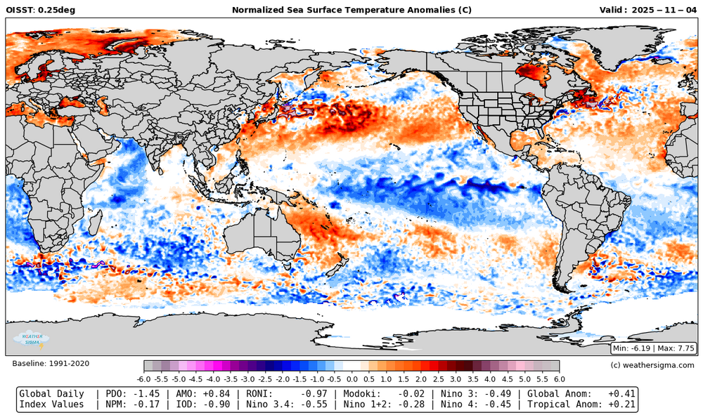
I've slowly been working on a weather model/ climate index page. I think it's far enough along to share. https://weathersigma.com/sst Within this tab you can select a range of dates to display. I've run it back to the start of 2024 if you want to check past data. Each map has a bunch of index values along the bottom. They don't perfectly agree with other sources but some of that is related to exact methodology, region of choice for the index, data set, and so on. My IOD doesn't run as cold as what I've seen on here, for example. If you find it useful, find errors, or it needs changes, let me know. But I hope it'll be useful. It updates daily like the world climate service site. The 2nd image is an IOD plot, which can be selected near the bottom of the menu.

-

2025-2026 ENSO
40/70 Benchmark replied to 40/70 Benchmark's topic in Weather Forecasting and Discussion
Yes, it's not ideal, though I would gladly take heaping serving of December 2007 with a side of December 2008. The ceiling in any single event isn't there, but they are defintely the safer bet in terms of a floor my area. There is a wide array of ways for my area to get proked in coastals, and I have found just about ever single one of them this decade independent of CC. -
king euro!
-

November 2025 general discussions and probable topic derailings ...
bobbutts replied to Typhoon Tip's topic in New England
Impact Weather: Winds knocked my empty garbage bin over this am. -
The 12z CMC has a general 2-3" of snow over the Plateau and 6-12" over the Smokies. NW slopes in the foothills should see some snow as well - time of day dependent.
-

November 2025 general discussions and probable topic derailings ...
Ginx snewx replied to Typhoon Tip's topic in New England
The buildup of snow in Eastern Canada is good thing going forward -
Coming into the city for the weekend for our bimonthly Broadway weekend. How much rain is the city looking at Sunday? I really don’t want to take an umbrella and hope my rain jacket will suffice …
-
All of that to say, I think chances are increasing for high elevation snow and lower elevation snow showers in the foothills in prime NW flow areas around Nov 10-11. Either way, it should be very cold with afternoon wind chills in the upper teens to lower 20s in many places.
-
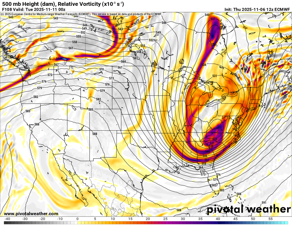
The 12z CMC vs yesterday's 12z CMC run is night and day different at 500. It is now almost identical to the Euro today at 12z. The GFS popping that low tells me that model is moving bigly to the Euro. We will see. Lots of support for the Euro solution where it had almost none yesterday with the exception of the 12z GEFS ensemble.
-
The Euro is interesting in that it is digging a potent 500 low which provides the dynamics needed for a post-frontal burst of precip. The GFS does not have this (nor does the AIFS for that matter). Probably a pipe dream, but worth keeping an eye on.
-
We know there have been some memorable snow chases at the beach, specifically Bethany and Rehoboth during previous winters such as this one coming up featuring Nina background state. This forecast has that area in 0 to 6 in. Will be interesting to reflect back on this forecast must we get to early March.
-

November 2025 general discussions and probable topic derailings ...
dryslot replied to Typhoon Tip's topic in New England
Looks like a gust of 39 mph at the house today, Winds always seem to under perform unless it involves convection. -
The 12z RGEM now has the system in range and has healthy bands of snow, rain/snow mix, and rain showers over the eastern half of the forum area - just like the Euro has had run-after-run for days. I am honestly surprised to see the Euro hold after missing so much last season and it being shoulder season.
-
Every pattern is different . You can think otherwise .
-
Gradient/SWFE patterns are a dream for your area and when things are right be okay here but definitely not what I’d prefer. South of Philly gets shut out in that type of pattern. Like I said-we can’t do anything about the laws of physics or reality. Without benchmark nor’easters that’s pretty much what MBY is stuck with when we can’t get 3-5” type clippers the way we used to. Selfishly I hope the NNE drought continues.
-
The Euro maintains it's basic camp for our region, the GFS does as well.
-
Shades of November 2018....
-
The 12z CMC now brings the backside energy in the form of heavy snow showers on NW flow...complete cave by it.
-

November 2025 general discussions and probable topic derailings ...
weathafella replied to Typhoon Tip's topic in New England
Yeah the wind advisory was a bit of a bust here though it gusted overnight for a short time as the front blew through. We continue to step. -
Pretty interesting development on the 12z GFS and a fair amount of change. It pops a low over the Piedmont of North Carolina as opposed the northern stream dominate solutions it previously had. If true, the Euro(if it doesn't flip at 12z) has scored a "1 vs everybody" coup.