All Activity
- Past hour
-
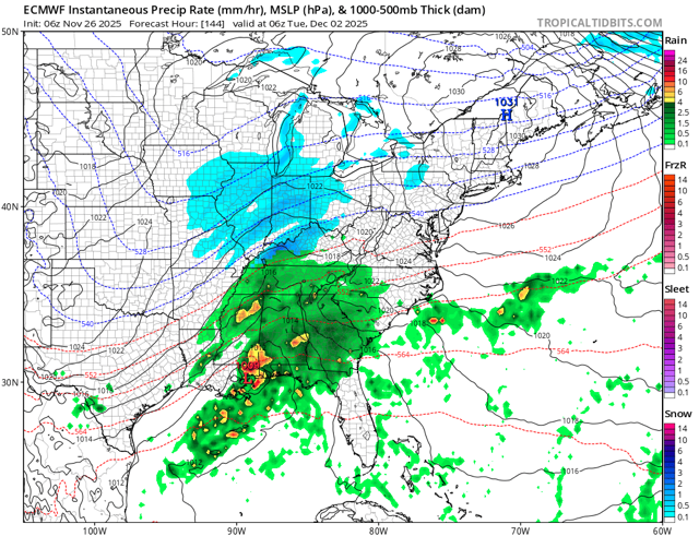
6z euro def better than 0z thru 144. So that’s something.
-
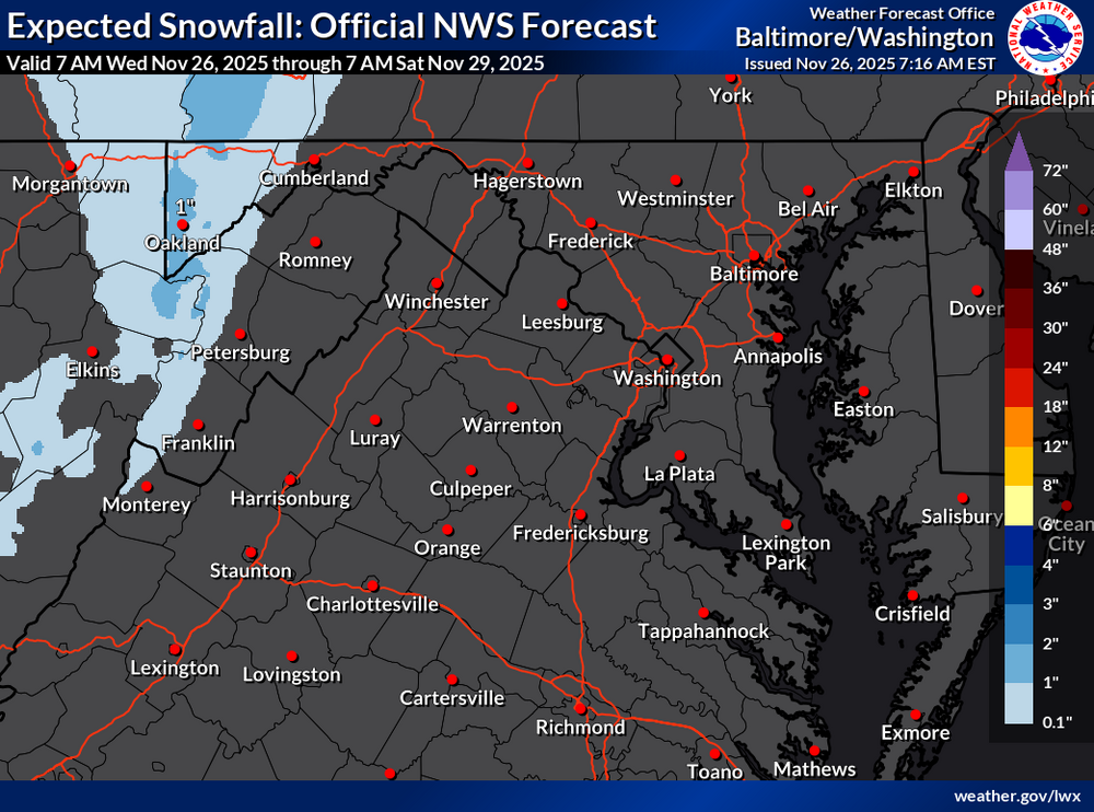
Overnight high of 51, currently 48 degrees. Latest from LWX for snow shower chances through Saturday.
-
@forkyfork Thoughts on next week’s storm?
-
Forecast for WXW2 keeps beefing up. Now 5” expected with the Thanksgiving storm. Need that a month from now. We’re doing Thanksgiving in CT and Christmas in SLK.
-

December 2025 regional war/obs/disco thread
Damage In Tolland replied to Torch Tiger's topic in New England
Seems like it’s moved towards more of Tuesday storm winding down by Wednesday morning now -
 54.2° here at WXW1. 38.8° at WXW2, warmest morning of the month. We torch before winter sweeps in. Thankfully short lived.
 -
Probably our warmest day of the week today with several spots approaching 60°.
-
There’s some decent energy rounding the base of the longwave trough after it moves east a bit so we get this brief window for a more coastal system. I think most subsequent threats beyond that are likely to be SWFEs. Previously for 12/2-12/3, the southern stream energy was hanging back in the southwest while northern stream moved over us…then, when the southern stream ejected a day or two later (say getting us by 12/5ish…which is why we were saying post-12/3 looked decent), it would push a SWFE up into the cold that was established ahead of it by the northern stream…but it’s not evolving like that now…instead, they are almost moving together so we get this threat to potentially materialize on 12/2…southern stream still lags a bit which is a good thing because it allows the baroclinic zone to set up offshore. But it’s still close enough that it can produce a coastal on some of these runs.
-
December 2025 regional war/obs/disco thread
Damage In Tolland replied to Torch Tiger's topic in New England
Hopefully it’s paste and not powder -

December 2025 regional war/obs/disco thread
WinterWolf replied to Torch Tiger's topic in New England
Lmao… -
3.1” at MSP. Still blowing and snowing
-
December 2025 regional war/obs/disco thread
Damage In Tolland replied to Torch Tiger's topic in New England
That’s not what I posted if you paid attention. I said we would see several snow chances . But the great promised month was slipping away. Selective reading is not good -
0.12" for the date, getting me to 1.27" for the month. A warm night, hanging in upper 40's, currently 49.5/48.3 at 7:45 with VERY dense fog.
-
Heisey! Don't be a stranger and be sure to let us know HM's thoughts as we get closer.
-
Looks great. Can’t wait for the NNE one.
-
Yeah, this is the reason that we don’t always get a perfect MJO composite match for the RMM charts. Multiple areas of forcing often lead to blended looks between the composites. Sometimes we get more consolidated forcing and it closely resembles a specific phase composite.
-
Yea it matches fairly well with 6z gfs. Long way to go, but a nice step. .
-
Make a list now and have one of the questions be: please explain if a scud cloud can be a tornado
-
felt so much colder than it is, def a bit of a slap in the face
-
Actually, I mentioned that last night. No way I'll let a classic weenie stand-by be forgotten. BUT, there some truth to that on occasion.
-
Maybe we can sublimate it away.
-
December 2025 regional war/obs/disco thread
WinterWolf replied to Torch Tiger's topic in New England
It’s slipping away bro..no pack for us. Cold all bottled up… -

November 2025 general discussions and probable topic derailings ...
dendrite replied to Typhoon Tip's topic in New England
Yeah my wife showed me this yesterday and I had to explain to her how it works. She wasn’t too interested lol. The top of the lenticular went up to the base stratus layer too so it made for some really cool photos. -
December 2025 regional war/obs/disco thread
Damage In Tolland replied to Torch Tiger's topic in New England
That pack will last and stay OTG with all that cold behind it