All Activity
- Past hour
-

November 2025 general discussions and probable topic derailings ...
dendrite replied to Typhoon Tip's topic in New England
So yeah…that’s your inverted trough moving through right now. The LES band is setting up in its wake and will move eastward with time.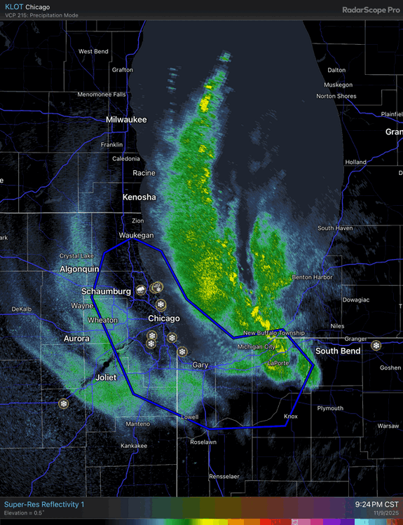
-

November 2025 general discussions and probable topic derailings ...
Snowedin replied to Typhoon Tip's topic in New England
Tropical downpours coming down good right now. Now I know why there’s been so many frogs hopping around this evening!
-
Chicago Webcam https://share.earthcam.net/tJ90CoLmq7TzrY396Yd88LOc-jcDgi0ca-YNv3MI9rc!.tJ90CoLmq7TzrY396Yd88G8-6CLOrQYCFNszQ91PWAs!.tJ90CoLmq7TzrY396Yd88DGHDxm0NvViWeCn-Q5a6NQ!/cub_world_sporting_goods_store/wrigley_field_cam/live
-
11/8-11/10 First Snow and Lake Effect Event
snowman33 replied to Geoboy645's topic in Lakes/Ohio Valley
Can't fathom what is happening, been burned too many times with LES. -
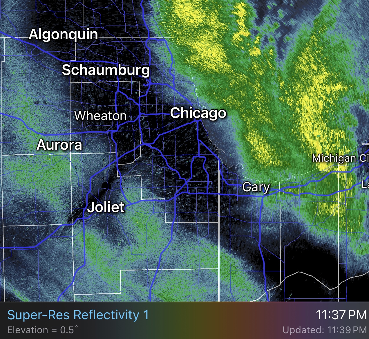
Just out from LOT (11:37 PM): THE INITIAL PUSH OF SNOW THAT DROPPED VIS DOWN TO 3/4SM AT CHICAGO TERMINALS IS PUSHING SOUTHWESTWARD TOWARD KPIA. HOWEVER, THE NEXT BAND OF SNOW IS RIGHT ALONG THE LAKE SHORELINE AT THE TIME THIS DISCUSSION WAS PUBLISHED. CURRENTLY CONDITIONS AT CHICAGO TERMINALS ARE VFR, BUT WITH THE NEXT BAND ABOUT TO MOVE ONSHORE, THE TAFS WERE SENT WITH WORSE CONDITIONS DUE TO THE EXPECTATIONS THAT THINGS WILL DETERIORATE QUICKLY AFTER 06Z. THIS BAND WILL BE HAVE MORE VIGOROUS SNOW RATES AND STRONG GUSTY WINDS. LOW VIS IS EXPECTED, BUT MAY EXCEED EXPECTATIONS AND BECOME SUB-1/4SM. ADDITIONALLY, BUOYS HAVE ALREADY REPORTED GUSTS TO 31 KNOTS, AND WHILE 35 KNOTS IS IN THE TAF, IT IS ENTIRELY POSSIBLE THAT GUSTS TOUCH 40 KNOTS AT TIMES. IT IS POSSIBLE THE THE TEMPO FROM 06Z TO 09Z IS A HAIR LONG, BUT HAVE MODERATE CONFIDENCE THAT THERE COULD BE 3 HOURS OF REALLY INTENSE SNOW RATES. LOOKING AT REGIONAL RADAR, THERE IS A LONG LAKE ORIENTED BAND OFF THE WISCONSIN SHORELINE MOVING SOUTHWARD. THIS BAND WILL BE "ROUND 2" AS IT MOVES INTO ILLINOIS. THERE WILL THE EXPECTATION IS THAT THERE WILL PROBABLY SOME TIME OF "BREAK" IN THE INTENSE SNOW BEFORE IT MOVES SOUTHWARD (LONGER AT KMDW AND KGYY). CAN'T RULE OUT SOME QUICK VFR CONDITIONS, BUT FELT MORE PRUDENT TO LEAVE IFR/MVFR CONDITIONS FOR ONGOING SNOWFALL. NEVERTHELESS, A SECOND ROUND OF INTENSE LAKE EFFECT SNOW IS EXPECTED BEFORE DAYBREAK.
-

11/8-11/10 First Snow and Lake Effect Event
homedis replied to Geoboy645's topic in Lakes/Ohio Valley
Absolutely ripping here. This feels like thundersnow any mintue now… https://imgur.com/a/6GqbyUD -

11/8-11/10 First Snow and Lake Effect Event
OrdIowPitMsp replied to Geoboy645's topic in Lakes/Ohio Valley
https://www.earthcam.com/usa/illinois/chicago/wrigleyfield/?cam=wrigleyfield_hd -

11/8-11/10 First Snow and Lake Effect Event
andyhb replied to Geoboy645's topic in Lakes/Ohio Valley
How has no one said "rdy 2 b buried" yet? -

11/8-11/10 First Snow and Lake Effect Event
sbnwx85 replied to Geoboy645's topic in Lakes/Ohio Valley
whiteout on the lakeshore. You can also drag the cursor back to see what the shot normally looks like. -
11/8-11/10 First Snow and Lake Effect Event
homedis replied to Geoboy645's topic in Lakes/Ohio Valley
Pouring snow in Wicker Park area, flake size has definitely improved. -

11/8-11/10 First Snow and Lake Effect Event
Malacka11 replied to Geoboy645's topic in Lakes/Ohio Valley
@A-L-E-K How is it -

11/8-11/10 First Snow and Lake Effect Event
OHweather replied to Geoboy645's topic in Lakes/Ohio Valley
Some pretty impressive ascent from the vort max and meso low!
- Today
-

November 2025 general discussions and probable topic derailings ...
Supernovice replied to Typhoon Tip's topic in New England
This looks fairly legit and I’m fairly jealous
-
Maybe some flurries this week ?
-

11/8-11/10 First Snow and Lake Effect Event
BuffaloWeather replied to Geoboy645's topic in Lakes/Ohio Valley
You're about to see a Buffalo band, hope you're still awake for this. -
Top 3 thunderstorm for the year here, and perhaps in quite a while. 5 minute pea sized hailstorm, which is rather rare in my local neighborhood. Absolutely torrential rain to boot. And now your never even know it rained. Sent from my Pixel 9 Pro XL using Tapatalk
-
11/8-11/10 First Snow and Lake Effect Event
OHweather replied to Geoboy645's topic in Lakes/Ohio Valley
Yeah it seems like they're alluding to it in their AFD as well. It may be hard to know exactly which way it'll go until the mesolow pushes farther inland/weakens a bit over the next few hours, as that's when the band will be more free to whip west, which it will still want to do based on radar trends farther up the lake. However, the shorter the window for that to happen the better for getting the band to stay more coherent. -
Some light accums have taken place in northern Summit over the last couple hours. On the board!
-

11/8-11/10 First Snow and Lake Effect Event
migratingwx replied to Geoboy645's topic in Lakes/Ohio Valley
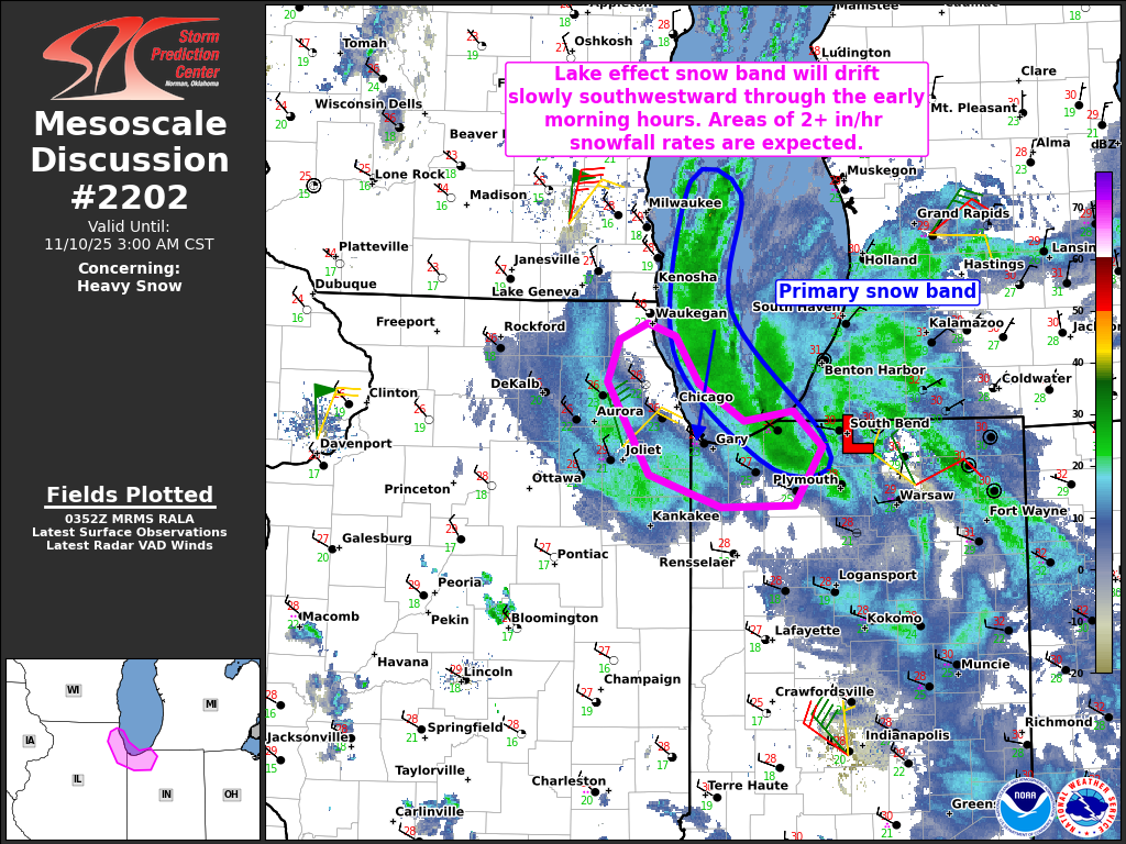
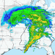
Mesoscale Discussion 2202 NWS Storm Prediction Center Norman OK 0955 PM CST Sun Nov 09 2025 Areas affected...Northwestern Indiana and northeastern Illinois Concerning...Heavy snow Valid 100355Z - 100900Z SUMMARY...An intense lake effect snow band will drift slowly south-southwestward across northwestern Indiana and northeastern Illinois through the early morning hours. Heavy snowfall rates of 2+ inches/hour are expected under the core of the band. DISCUSSION...Regional radar data shows a well-defined snowband favorably oriented along the long axis of Lake MI. This snowband is on the backside of a mesoscale low that evolved off of Lake MI and is moving slowly southward across far northern IN. As this feature continues southward, and low-level flow continues veering to a north-northeast direction over Lake MI, the band will have a tendency to drift gradually south-southwestward across far northwestern IN and northeastern IL through the early morning hours. The 00Z GRB sounding sampled very cold temperatures aloft (-40C at 500 mb), which is yielding steep low/midlevel lapse rates and a deep convective boundary layer (aided by relatively warm lake waters). Given the favorable/persistent orientation of low-level flow down Lake MI and significant convective enhancement, heavy snowfall rates of 2-3 inches per hour are expected under the core of the band as it continues south-southwestward. Isolated lightning flashes will also be possible. There will likely be a sharp drop-off in the heaviest snowfall rates as the band tracks southwestward across northeastern IL (owing to less favorable thermodynamic conditions), though exactly where this will occur is uncertain. Additionally, gusty winds within the band will yield significant visibility reductions where snowfall rates are maximized. ..Weinman.. 11/10/2025 ...Please see www.spc.noaa.gov for graphic product... ATTN...WFO...IWX...LOT... LAT...LON 42278765 41998745 41768708 41818669 41608645 41248667 41228727 41438787 42008820 42268810 42358788 42278765
-

11/8-11/10 First Snow and Lake Effect Event
Chicago916 replied to Geoboy645's topic in Lakes/Ohio Valley
That more or less seems like what LOT just hinted at on Twitter too. Less likely there will be "slight break before a 2nd band". Seems to imply this will be the sole band now. Definitely would boost odds of some higher totals. -
11/8-11/10 First Snow and Lake Effect Event
sbnwx85 replied to Geoboy645's topic in Lakes/Ohio Valley
Laporte getting wrecked thanks to the stalled mesolow. Current conditions at La Porte Municipal Airport (KPPO) Lat: 41.57°NLon: 86.73°WElev: 812ft. Heavy Snow Freezing Fog 30°F -1°C Humidity 100% Wind Speed W 16 G 35 mph Barometer 30.05 in Dewpoint 30°F (-1°C) Visibility 0.15 mi Wind Chill 19°F (-7°C) Last update 9 Nov 9:55 pm CST -

E PA/NJ/DE Autumn 2025 Obs/Discussion
KamuSnow replied to PhiEaglesfan712's topic in Philadelphia Region
Looking like an overperformer here, up to 0.75" of rain!
-
11/8-11/10 First Snow and Lake Effect Event
OHweather replied to Geoboy645's topic in Lakes/Ohio Valley
I don't think the band taking slightly longer to swing west is a bad thing for the immediate lakeshore/Chicago area (and probably ups the odds at someone getting a higher-end total)...some earlier model depictions had it swinging west and breaking into weaker multi-bands pretty quickly (before congealing as it swings back east on Monday). This slower west push right now may allow for a more focused band that lasts longer close to the lake later tonight. -
Was just about to comment on that. Nothing from NWS?
-
Fascinating very detailed update just a few minutes ago from Chi NWSFO explaining how difficult this forecast is:UPDATE ISSUED AT 944 PM CST SUN NOV 9 2025 HAVE EXPANDED THE WINTER WEATHER ADVISORY TO INCLUDE FORD AND BENTON COUNTIES, OTHERWISE NO CHANGES TO THE MANY, MANY HEADLINES IN EFFECT. ALSO, NO BIG CHANGES TO THE FORECAST GRIDS THIS EVENING. CONVECTIVE ALLOWING MODELS (CAMS) OFTEN STRUGGLE WITH THE EXACT DETAILS OF LAKE EFFECT SNOW, MUCH LIKE THEY DO WITH SPECIFICS OF SUMMERTIME CONVECTION. THIS WAS THE CASE THIS EVENING WITH THE MOVEMENT AND TIMING OF THE LAKE INDUCED/ENHANCED MESO-LOW, WHICH MOVED INLAND INTO NORTHERN IN HOURS EARLIER THAN MOST CAM GUIDANCE HAD BEEN INDICATING. THE FASTER AND FARTHER EAST TRACK OF THIS MESOLOW HAS RESULTED IN CAMS BEING WRONG IN THEIR DEPICTION OF A LARGE INITIAL WESTWARD SURGING LAKE EFFECT SNOW PLUME WELL INLAND INTO NORTHEASTERN IL LATE THIS EVENING. RATHER, THIS MESOLOW HAS BECOME NEARLY STATIONARY OVER NORTH CENTRAL INDIANA WITH A COHERENT, INTENSE SINGLE BAND OF LAKE EFFECT SNOW EXTENDING NORTHWEST THEN NORTH UP THE SPINE OF THE LAKE FROM THIS MESOLOW. SURFACE OBSERVATIONS DEPICT A SHARP SURFACE TROUGH EXTENDING NORTHWEST FROM THE MESOLOW ACROSS SOUTHERN LAKE MICHIGAN. THIS TROUGH AXIS HAS BEEN STEADILY MOVING SOUTHWARD DOWN THE LAKE, WITH THE STRONG LOW LEVEL NORTHEASTERLY FLOW IN THE WAKE OF THIS TROUGH HELPING PUSH THE LAKE EFFECT PLUME STEADILY WESTWARD. AS THIS TROUGH CONTINUES TO PUSH SOUTH OF THE LAKE, ANTICIPATE THAT WESTWARD PROGRESSION OF THE LAKE PLUME SHOULD PUSH IT INTO NORTHEAST IL BETWEEN 11 PM AND MIDNIGHT. CONFIDENCE IS LOW IN HOW FAR WEST THIS PLUME WILL GET INTO NE IL BEFORE BECOMING QUASI-STATIONARY FOR A TIME, THEN LIKELY SHIFTING BACK EASTWARD TOWARD AND ACROSS NORTHWEST IN MONDAY. REALLY NOT PUTTING A TON OF STOCK IN CAM GUIDANCE AT THIS POINT, SO ONCOMING MIDNIGHT SHIFT WILL BE NOWCASTING THIS BAND THROUGH THE NIGHT BASED ON OBSERVATIONAL TRENDS. NO CHANGE TO THE MAGNITUDE OF INSTABILITY, WHICH IS CONFIRMED BY A SPECIAL 0030Z VALPARAISO UNIVERSITY SOUNDING FROM THIS EVENING. STILL ANTICIPATE SNOWFALL RATES OF AT LEAST 2-3 INCHES PER HOUR WITHIN THE HEAVIEST ELEMENTS OF THIS BAND. DEPENDING ON HOW LONG THE BAND BECOMES QUASI-STATIONARY, IT IS CERTAINLY POSSIBLE THAT WE COULD SEE ISOLATED TOTALS PUSHING OR EVEN EXCEEDING A FOOT BEFORE THE BAND BEGINS SHIFTING EASTWARD. CURRENT TRENDS WOULD SEEM TO SUGGEST THAT LAKE OR COOK COUNTY IL COULD BE THAT WESTWARD TERMINUS THAT SEES SOME OF THE HEAVIER TOTALS. WHERE EVER THE BAND IS DURING RUSH HOUR TOMORROW MORNING, TRAVEL CONDITIONS WILL BE VERY DIFFICULT TO NEARLY IMPOSSIBLE. - IZZI