All Activity
- Past hour
-

Winter cancelled/uncancelled banter 25/26
North and West replied to Rjay's topic in New York City Metro
. -
Looks like the BAJA low never kicks east with 12
-
Tells me south of 40 Op is out to lunch...as much as the Op was fun to watch, we may have seen the peak in it if the amped solution is where we are headed.
-

January 25/26 Jimbo Back Surgery Storm
NorthHillsWx replied to Jimbo!'s topic in Southeastern States
Even though the GFS ticked north with precip and mixing, it actually ticked colder just about everywhere at the surface. There is going to be an epic battle going on in the mid levels with this one. It actually ticked colder at 850 in Virginia -

January 2026 regional war/obs/disco thread
Kitz Craver replied to Baroclinic Zone's topic in New England
That’s evident increase lock step each run -
Mabrook(means congrats in Arabic) The euro has initialized
-
January 2026 regional war/obs/disco thread
Kitz Craver replied to Baroclinic Zone's topic in New England
SNE has a shot, just hope we can get into some of the meat and not dim sun arctic sand -

January 2026 regional war/obs/disco thread
ineedsnow replied to Baroclinic Zone's topic in New England
-
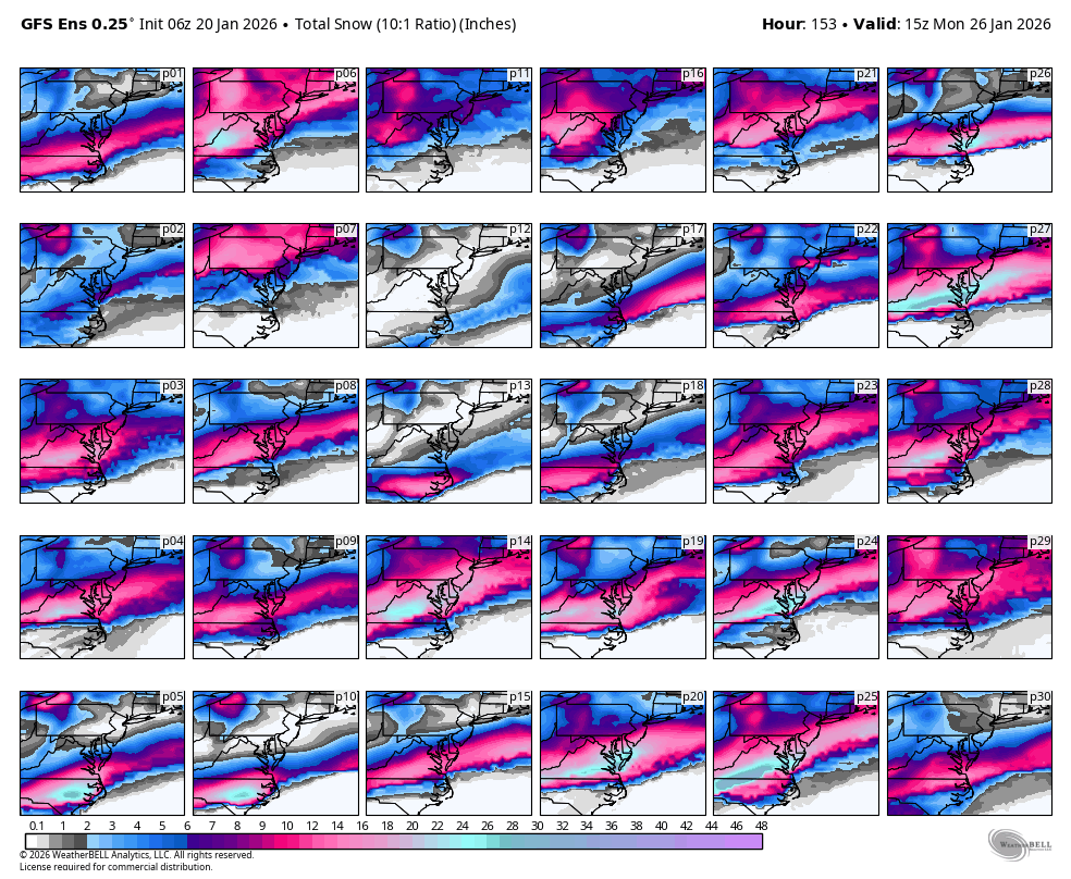
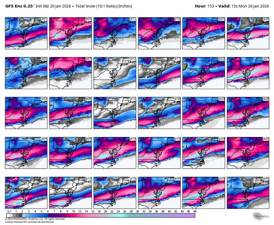
Just insane stuff right here. GFS showing over 2 feet up this way...
-
What happened with p12?
-
Goooood morning weenies! Nice runs overnight. Get your banter out of your system, I’m awake and paying attention
-

January 2026 regional war/obs/disco thread
Damage In Tolland replied to Baroclinic Zone's topic in New England
Tick tick tick as the models slowly start to pick up on less confluence -

January 2026 Medium/Long Range Discussion
Stormchaserchuck1 replied to snowfan's topic in Mid Atlantic
Sometimes they take the cold in the next 25 days and run that out. I don't think the surface will be that cold if that Pacific H5 comes to be. They seem to want to make west-based -NAO the dominant pattern, but almost all the time the Pacific has more weight. It's far out, so maybe that somewhat weak Pacific H5 won't even verify, it's suppose to be a Nina pattern this year on seasonal models and such and we are very +PNA for the next 15+ days. -
WB 6Z GEFS: several big hits!
-
06z gfs obliterates the ATL with inches of ice and snow. This truly could be the worst devastating storm to hit ATL. I'm not joking. We could have many deaths and people with no heat and water for weeks. I seriously hope this doesn't happen as depicted.
-
Pretty cold look if accurate
-
I just woke up and don't believe my eyes.
-

E PA/NJ/DE Winter 2025-26 Obs/Discussion
Fields27 replied to LVblizzard's topic in Philadelphia Region
GEFS with a nice bump N. Sent from my SM-S938U using Tapatalk -
.
-
What is it seeing that makes it want to cut the northern edge precip down so much? Seems like this was a bigger drop than just noise. I see the answer above. Thanks, @Terpeast
-
January 2026 Medium/Long Range Discussion
Stormchaserchuck1 replied to snowfan's topic in Mid Atlantic
^Hopefully that Pacific doesn't come to be. I can see that being a 40N pattern. Neutral H5 Alaska and cold NW Canada is sneaky surface level warm air if it holds the same pattern as it gets closer. -
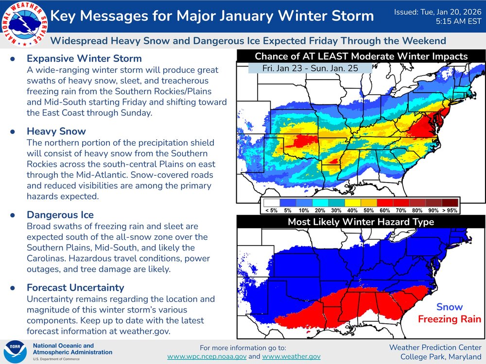
Updated this morning. It’s been a long time since we’ve had one of these storms seemingly lock in at this range. The signal is strong with this one.
-
Actually GFS AI is very similar to op GFS at both 500mb and sfc low positions. It's the precip shield that's a bit different, but I don't trust AI models on precip. I trust them more on 500mb and storm tracks
-

Possible Record Breaking Cold + Snow 1/25 - 1/26
Jersey_Snowhole replied to TriPol's topic in New York City Metro
Yeah strong signal on the GEFS -

Central PA Winter 25/26 Discussion and Obs
mahantango#1 replied to MAG5035's topic in Upstate New York/Pennsylvania