All Activity
- Past hour
-
Cut my trees into pieces. This is my last resort.
-

2025 Atlantic Hurricane Season
BarryStantonGBP replied to BarryStantonGBP's topic in Tropical Headquarters
strong disagreement per the cycling theory from 2023-25, there will likely be a Gulf landfall in mid-late September (watch out for either the 16th or 25th September for an impact date), an OBX brush late September-early October, and a GA/SC landfall or brush in mid October -
-
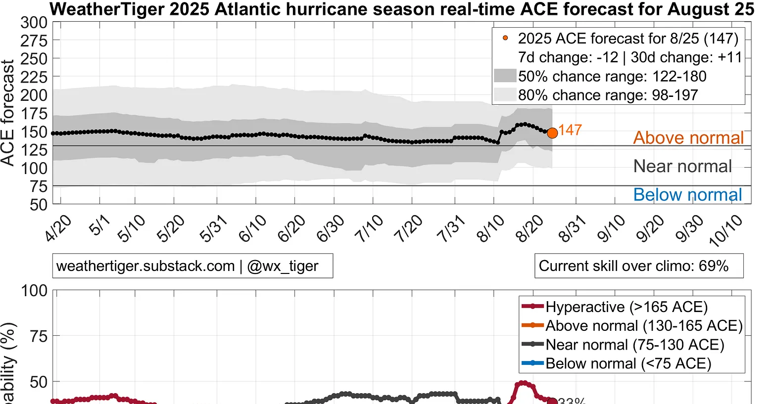
WeatherTiger update is out: opinions? https://weathertiger.substack.com/p/real-time-2025-atlantic-hurricane?utm_source=substack&utm_medium=email&utm_content=share Cycloneye of Storm 2K said this about this update: Down to 147 today, will probably dip into the 130-135 range by 9/10 unless we unexpectedly generate some ACE before then. More importantly U.S. ACE is falling as well, odds of 3+ U.S. hurricane landfalls now less than 25%. —————- My take: Seasons with 3+ H hits on the US are considered quite active for the US. They include these over the last 30 seasons (current active era): 2024, 20, 17, 08, 05, 04, 1999, 98 So, that’s 8 out of 30 or 27% with 3+ US H hits. Thus, he’s saying odds of 3+ have dropped to slightly lower than the normal chance of the active era. That seems to me like a reasonable drop considering the chance of the first prior to Sept 7th is low per models.

-
fingers crossed for fall classic and no snow on halloween (if only for the bad vibes)
-
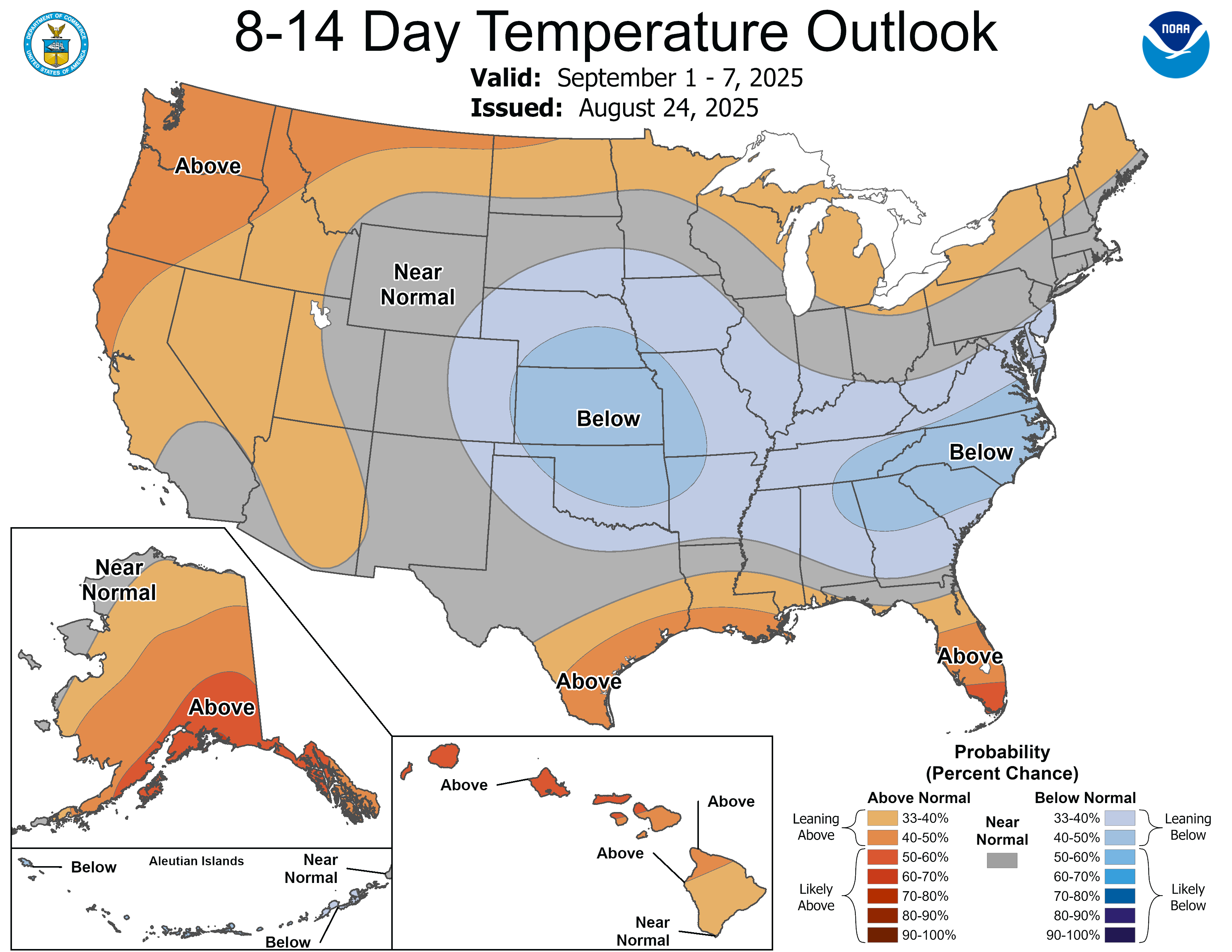
 90 degree days are just about done for the year (unless we get something like 10/2/2019). For the second straight year, comfortable conditions and a lack of heat will dominate the US Open in Flushing:
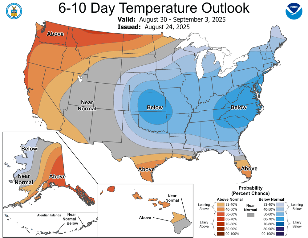
-
yup, not convinced that lake temps in august matter for LES when it turns over, it turns over and late summer surface temps aren't going to matter they're big and deep
-
Opinions? https://weathertiger.substack.com/p/real-time-2025-atlantic-hurricane?utm_source=substack&utm_medium=email&utm_content=share Per Cycloneye of Storm 2K, WeatherTiger is suggesting: Down to 147 today, will probably dip into the 130-135 range by 9/10 unless we unexpectedly generate some ACE before then. More importantly U.S. ACE is falling as well, odds of 3+ U.S. hurricane landfalls now less than 25%. —————————— Seasons with 3+ H hits on the US are considered quite active for the US. They include these over the last 30 seasons (current active era): 2024, 20, 17, 08, 05, 04, 1999, 98 So, that’s 8 out of 30 or 27% with 3+ US H hits. Thus, he’s saying odds of 3+ have dropped to slightly lower than the normal chance of the active era. That seems to me like a reasonable drop considering the chance of the first prior to Sept 7th is low per models. *Corrected

-
I see the theory but in reality it doesn’t really matter this time of year. As long as we don’t stay 20 degrees below normal until winter… and the winter brings arctic blasts over the lake in Nov, Dec, Jan we are good. Locally our best lake effect events come in January, historically, as long as the lake isn’t frozen over. But that would be the result of a frigid December.
-
2025-2026 ENSO
PhiEaglesfan712 replied to 40/70 Benchmark's topic in Weather Forecasting and Discussion
The difference between those years and this year is that in those years, the signs were there early on for an active hurricane season. This year is skewed by one storm, almost like Andrew in 1992. 2005 was a record-breaking season from start to finish. Still holds the record for highest ACE, most hurricanes, most major hurricanes, most category 5 hurricanes, and latest storm on record. The records that 2005 has since lost is most named storms (to 2020) and earliest category 5 hurricane (to 2024). There is nothing showing there will be an active hurricane season this year. If anything, it looks more like 1992 (with the active Pacific) than 2005, 2020, or even 2024. We won't get 75-82 ACE after October. I can almost assure you that. 75-82 ACE might be the whole season total (1992's total was ~76 ACE, and that was with Andrew skewing the numbers). -
75 at noon. Headed to Baltimore to see the Sox, should be a very pleasant evening for baseball.
-
Chilly day yesterday. Low max temps; I-Falls 62 (8th), Hibbing 57 (3rd), Duluth 57 (t3rd), Brainerd 65 (t6th), Ashland, WI 60 (t2nd). This morning's lows I-Falls 36 (5th), Hibbing 36 (3rd), Duluth 43 (t4th), Brainerd 44 (t7th).
-
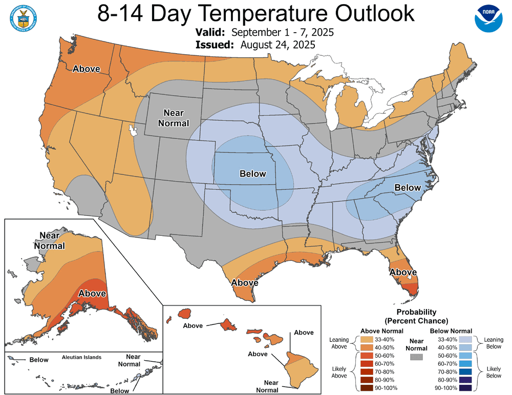
Indeed. We've earned a nice couple weeks, I think. Late August-early Sept is a great time to have normal/below normal high temps. We usually seem to excel at getting those in March/April
-
 Yeah being out in the dakotas just east of the mountain time zone it was still light at like 930 back in mid July. Of course it was also still dark at 6am
 -
I’ll put this out here for potential discussion purposes. From met. Tony Brite: Edit: one caveat. Tony Brite is assuming 2025 will be just cold neutral ENSO. But per RONI, weak La Niña is actually favored. Also, my research suggests weak La Niña may actually be worse than cold neutral as far as the chance for a rough US hurricane season.
-
It depends on whether starting the cooler wx this early, and we see more of it thru Sept. Then it will. Recent years have seen some pretty large LES dumps due to very warm waters going into the winter season. Waters do cool pretty quickly if colder air stays around long enough. Hope that's the case this year. Better to have manageable LES events than up to your roof in one event.
-
 83 / 53 here nice little breeze great day.
 -
If we still have, say, 60 or less ACE by 9/30, then I’d agree that the chances for an active season ACEwise would be way down. However, that wouldn’t mean no chance when considering that 2024, 2020, and 2005 each had 75-82 ACE Oct 1st+. That would mean that 140 would still be technically attainable on the high end.
-
Stein Stein everywhere is Stein Mucking up the greenery, breaking his mind Grow this, cant grow that Can't you see the Stein?
- Today
-
Stein, stein, everywhere a stein F*ckin' up the greenery Breakin' my mind Do this, don't do that Can't you feel the stein?
-

Central PA Summer 2025
Mount Joy Snowman replied to Voyager's topic in Upstate New York/Pennsylvania
I may regret this but @TimB may I ask why you have started putting laughing emojis on most of @ChescoWx's posts? I mean, if you just don't like the guy or disagree with some of his general themes, that's fine, but laughing at every post seems a bit much. Most of the posts are just brief summaries and forecasts that aren't controversial in any way. As an example, below is his post from last Wednesday, which I believe is the first one you started mocking. I can't think of a more benign harmless post. Food for thought. "We saw some light rain amounts overnight and this early AM including 0.05" at both Glenmoore and East Nantmeal. Shower chances will continue both today and tomorrow with continued cooler than normal temperatures. We clear up Friday and Saturday with our temperatures rebounding to near normal before a cold front moves through on Sunday which will allow for the return of an autumnal feel in the air." -
 Or just be on the western end of a time zone. We're on the wrong side for evening light
 -
HHH we salute you 1 final time, until Christmas
-
All we can do is wait and watch. I will say this however, if we get to the end of September and are still waiting for things to get active with the number of tropical systems/ACE, then I think it will be time to give it up
-
.thumb.jpg.ad3a2e31d30aff035044689b311a0540.jpg) nvck changed their profile photo
nvck changed their profile photo -
 Enter your September forecasts below ... this post will eventually be edited, the seasonal max info will move here and that post will change to updated annual scoring which so far has not been added to preliminary August scores three posts back.