All Activity
- Past hour
-
Colder weather looks to return within the next few days. But the 1/6-1/11 thaw ended up turning into 1/6-1/15 thaw. Temps weren't too warm, made it to 52 or 53 a few times, but the duration is a bit sizeable. That being said, the cold air coming down the pike will likely push the month below average in terms of temps
-
It will be interesting to see if that storm cuts or we stay on the cold side of the boundary, although recent trends make me think it's gonna cut. Plus side is that the Jan 18 one could be a sneaky threat for DC and east.
-
even Ben Noll thinks it could get cold and snowy for the last week of January. Thats like JB saying that any winter is going to be warm
-

January 2026 regional war/obs/disco thread
Typhoon Tip replied to Baroclinic Zone's topic in New England
Bingo... absolutely. That's all three, GGEM, GFS and now Euro... well, they've been doing this for days actually; it's been a matter of how much or how little. If you look at that run fro 00 to 200+ hours, it is doing that I think 4 times with a wave capable of dystopian cryo hell ... getting it's nuts cut off by the a blade cutting S too close on it's heals. That is why the 20th probably goes like the 18 ...and the 22nd or whatever ...etc I mean we'll see if this changes. But that 20th look there proooobably doesn't get more amped and do the NJ thing... as the forcing's leaning against because of all this -
The elusive I95 runner
-

Occasional Thoughts on Climate Change
TheClimateChanger replied to donsutherland1's topic in Climate Change
-
Up to 49 here sunny.
-
Just saw on X that California is drought free for the first time in a while. I guess the dryness went back east to visit relatives.
-
Might be here, lol. Was 23.9 for a low, currently 49.6 at 1:20 pm. What we HAVE succeeded in is another 'windy' day, already had a 26 WSW wind at 12:13 pm. Currently W at 11 gusting 19 mph. Amazing that the forecast at 7 am said nothing about winds until late afternoon when they 'may increase to 7-12 mph', fail. I still say we could have a 1050 high right overhead and still manage a 25-30 mph wind gust somehow.
-
The Euro suite has been continuously overdoing the NW trough/SER all season in the LR. That said, eventually it is going to be right, and late Jan/Feb in a Nina is often SER season. On the other hand, if we continue to have a strong -EPO, a moderately negative PNA can help fight against over-suppression. As you know it's always a knife's edge down here.
-
Hoco deathband!
-

January 2026 regional war/obs/disco thread
Sey-Mour Snow replied to Baroclinic Zone's topic in New England
Canadian Parallel has had this threat as well. Something to keep an eye on.. -

January 2026 regional war/obs/disco thread
40/70 Benchmark replied to Baroclinic Zone's topic in New England
I do the same thing, and people respond in like fashion. -
January 2026 regional war/obs/disco thread
Typhoon Tip replied to Baroclinic Zone's topic in New England
Oh I know - sorry... that sounded like I was yelling at you, huh. haha I swear I was just using that as a diatribe catapult. -
The point was the SE ridge is transient. And its an op run at range. Ens means have been depicting a flat/suppressed ridge and a gradient look with colder air just to the north and avg to slight below for our area.
-

January 2026 regional war/obs/disco thread
weatherwiz replied to Baroclinic Zone's topic in New England
That would be nice. Certainly enough time to where that is plausible...that could be wishful thinking it just goes to show it wouldn't take much. That shortwave digging into the northern Plains there may be inhibiting such a scenario? -
January 2026 regional war/obs/disco thread
40/70 Benchmark replied to Baroclinic Zone's topic in New England
John, I wasn't debating anything or pushing back against CC...I was merely pointing out that. That said, we have both agreed the current snow-drought isn't purely a product of CC. It's making it worse, I'm sure. -
The intent was Nasty.
-
January 2026 Medium/Long Range Discussion
TheClimateChanger replied to snowfan's topic in Mid Atlantic
-
Careful, I mentioned something along this line yesterday and we got 2 pages doom and gloom!
-
GEFS still looks interesting for that window, although the boundary probably is a tad further north than we want verbatim.
-
-PNA still showing up some in the long range. Trend has been for the cold to be overdone in the NW this year though. We'll see.
-
you forgot to show him this part where it shows no chance for a storm
-
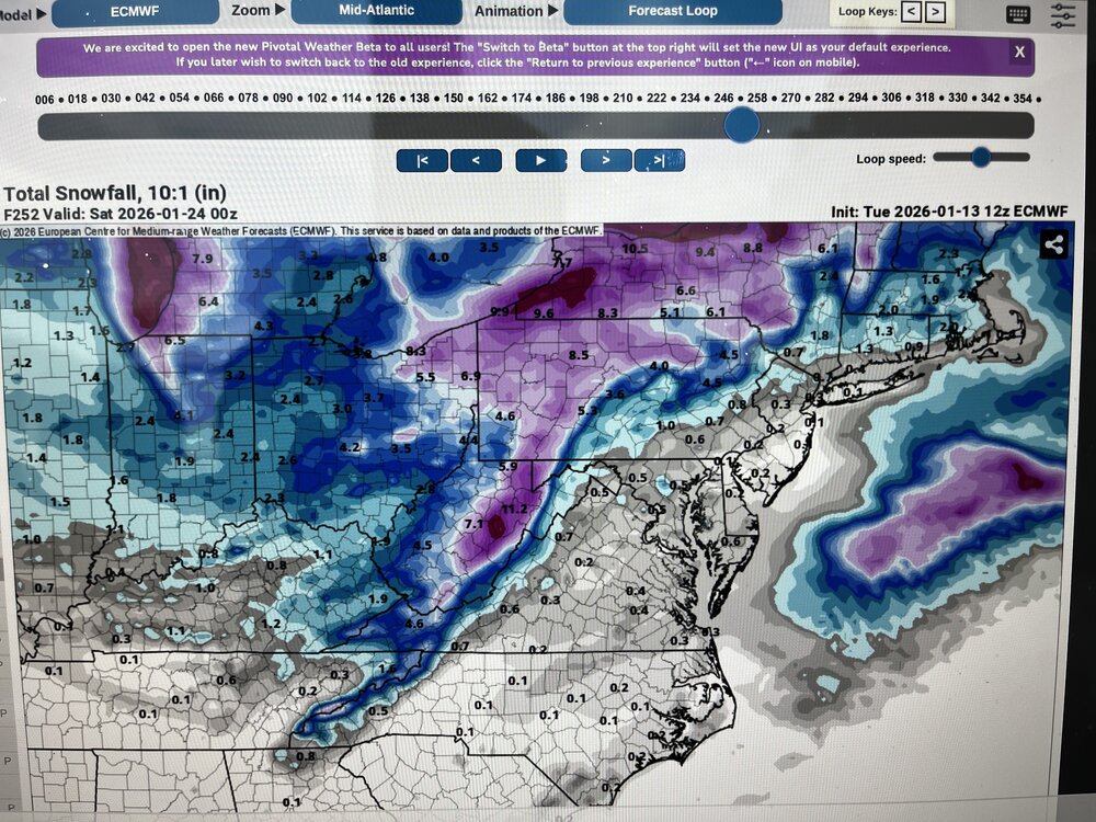
Why don't you mention that it is a total turn around from the 0Z run and too far out for an OP run to even consider . There also should be a rule around here that if you post a model run analysis you must post graphics
-
January 2026 regional war/obs/disco thread
Typhoon Tip replied to Baroclinic Zone's topic in New England
I'd like to get that vort tube's trajectory off the NJ coast as opposed to LI ... If so that would be a NJ bomb model low... Like 1987 November, but a cold profile.


