All Activity
- Past hour
-

2026-2027 El Nino
40/70 Benchmark replied to Stormchaserchuck1's topic in Weather Forecasting and Discussion
It's because the warming of the western Pacific has outpaced eastern Pacific, which fosters a cool ENSO paradigm. -
Clearing to our west we'll jump once that comes in
-
2026-2027 El Nino
40/70 Benchmark replied to Stormchaserchuck1's topic in Weather Forecasting and Discussion
Weak-moderate is absolutely better than strong in my region. -

Let’s talk winter!! Ohio and surrounding states!! 24'-25'
buckeye replied to buckeye's topic in Lakes/Ohio Valley
Looks like we wrap up 2025-2026 with official CMH snowfall 33.9. Not bad, first above normal in awhile...and maybe for awhile longer if all these super nino predictions come to fruition. Back to the miserable winters of the late 90's. -
95 was pretty brutal maybe you're thinking of 96?
-
Currently sitting at 56. Don’t see how we hit the forecast high of 77
-
(002).thumb.png.6e3d9d46bca5fe41aab7a74871dd8af8.png) "That is a clear sign of a major station change, probably at Morgantown." That would be incorrect Charlie no station changes took place at all during the period that temperatures were reported by the NWS Coop observer. There were some moves after those temperature obs ended and they moved to just precip and snow obs.
"That is a clear sign of a major station change, probably at Morgantown." That would be incorrect Charlie no station changes took place at all during the period that temperatures were reported by the NWS Coop observer. There were some moves after those temperature obs ended and they moved to just precip and snow obs.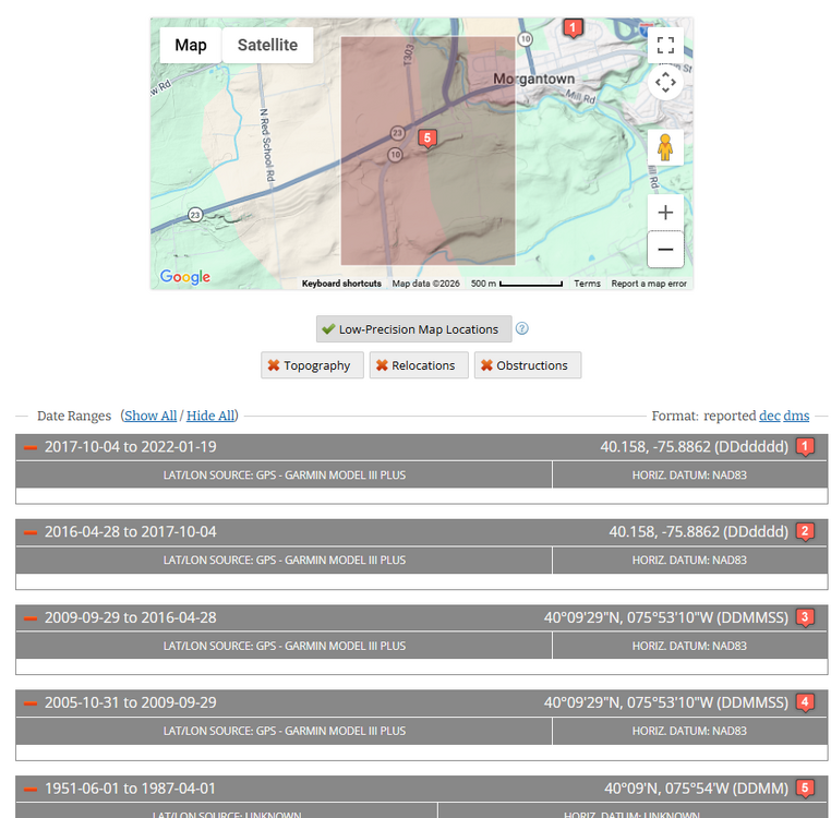
-
2026-2027 El Nino
40/70 Benchmark replied to Stormchaserchuck1's topic in Weather Forecasting and Discussion
Let me preface this by admitting that I am still on my annual hiatus and won't begin really diving in until latter May/June....but I remain skeptical of an uber-strong El Nino. My larger concern is the continued lag between the RONI and the ONI being reflective of what will ultimately be a partial masking the warm ENSO, and thus a reduced north Pacific response, which would mean a less pronounced GOA low. I do not expect a result as dire as 2023 because we seem to have a changed longer-term WPO modes, but I would, nonetheless, like to see that delt between the RONI and ONI close with time. -
61 / 54 clouds. Warmup upon us with peak surge of warmth/heat this week Tue - Sat. Beyond there cools down towards normal and perhaps below 4/20 - 4/27. Overall dry otherwise and this weeks warmth will outdo any cooldown vs normals, the following week.
-
Summer 2023 was a delayed summer. It was one of those rare ones where September was warmer than June. While JJA fell a tenth or two below the 1981-2010 average, the JAS temperature finished a tenth or two above the 1981-2010 JJA average. Plus, the early September heatwave helped drive up the 90-degree numbers for 2023. Also, I'm not sure where the narrative of record rainfall and flooding events going into the summer of 2023 came from, but aside from the April 28-30 rainstorm, that spring was pretty much dry here, with May 2023 being a record dry May. It really didn't get wet until about mid-June.
-
Yup. NCAR is NOMORE
-
Average precip here for those 16 days is 2.2". Would be nice to reach the average at least as we've been running at 60% since last June, though it would probably need 10-12 days with rain to get there.
-
This sucks @40/70 Benchmark With the NWS discontinuing NCEP/NCAR R1 and the switch to CORe, if I'm understanding what I'm reading correctly, PSL is not going to offer plotting of CORe, although it is listed under the list of datasets. NCEP.NCAR R1 will still be available for reanalysis purposes but may have to switch over to ERA5
-
A very confused person.
-
Man, can’t win. Looks warmer this week, but a lot of overcast it appears.
-
Central PA Spring 2026 Discussion/Obs Thread
ChescoWx replied to Voyager's topic in Upstate New York/Pennsylvania
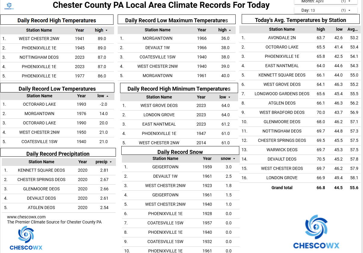
We start our major warm up today with temperatures reaching well into the 70's. We warm into the 80's on Tuesday with our warmest days both Wednesday and Thursday. While places along the I95 corridor could see record highs in the 90's it looks like we should stay in the middle 80's here in Chester County. Our Chester County record high for Wednesday is 89 degrees set in Phoenixville way back in 1941. Thursday's record high is 92 degrees set at multiple county stations back in 1896 and 2002. We have a slight chance of showers this afternoon and again on Wednesday night, but our best chance of any showers looks to arrive on Saturday night.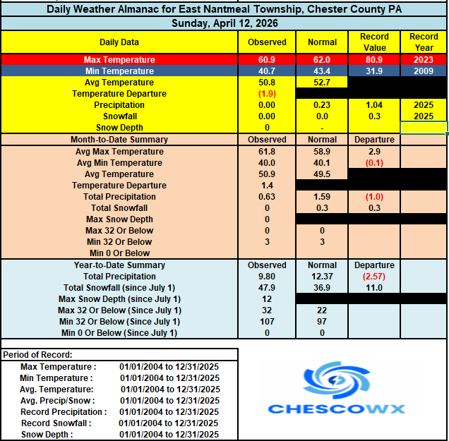

-
E PA/NJ/DE Spring 2026 Obs/Discussion
ChescoWx replied to PhiEaglesfan712's topic in Philadelphia Region
We start our major warm up today with temperatures reaching well into the 70's. We warm into the 80's on Tuesday with our warmest days both Wednesday and Thursday. While places along the I95 corridor could see record highs in the 90's it looks like we should stay in the middle 80's here in Chester County. Our Chester County record high for Wednesday is 89 degrees set in Phoenixville way back in 1941. Thursday's record high is 92 degrees set at multiple county stations back in 1896 and 2002. We have a slight chance of showers this afternoon and again on Wednesday night, but our best chance of any showers looks to arrive on Saturday night.
-
That’s not quite how it works. Climate change reinforces these large heat bursts by well over 1.5 degrees. It’s not as if the earth uniformly just steps up 1.5 degrees. The heat burst out west last month was a feedback loop where heat was able to really build and build due to higher CO2. the same goes for actually cool summers. Those are much less likely now because of new atmosphere we have, even though global temperatures in aggregate have increase a few degrees.
-
Progress ... some sky lights unzipping. I just hate it when these cloud packed mornings do this and waste days. It's a spring thing...
-
-
On a lighter note, my tribute to the successful Artemis mission
-
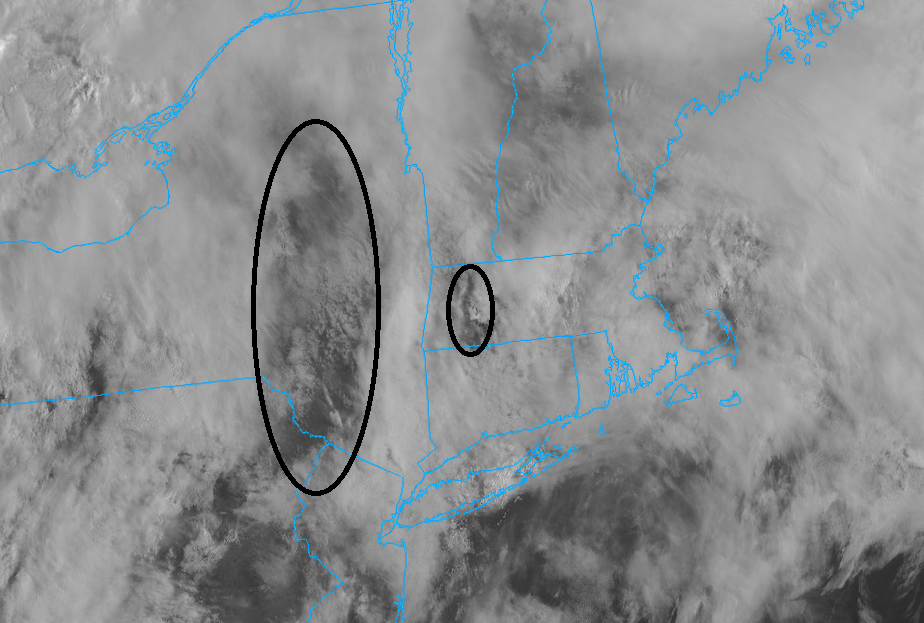
Models have been hinting at this potential for the past 7-8 days with very little wavering...pretty impressive to see. I wouldn't be surprised if that got extended a bit east as well. One downside though is the overall forcing doesn't appear particularly strong. What this is going to do is likely negate this from producing scattered thunderstorm activity within the region as a whole. The best likelihood is probably going to be across like VT/NH/northern MA where there may be some better forcing and also on the edge of the stronger llvl airmass/theta-e gradient. Probably see at least one cluster roll through here. Maybe differential heating can pop some stuff elsewhere
-
This week is going to be brutal for sure. It is painful to see so many 90's F in the forecast this early ugh.
-
Saw a lot of commentary online criticizing them for it too. People have no clue how hard it is to get any grass looking healthy in a drought with Georgia heat, let alone bentgrass greens. I agree, irrigation helps to a degree but it can’t replace the type of soaking that rain delivers.
-
...can use this too.National 7-Day Significant Fire Potential