All Activity
- Past hour
-
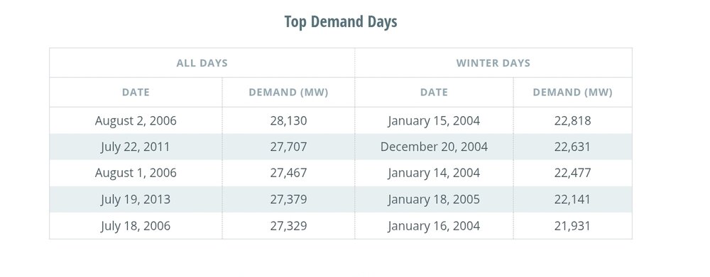
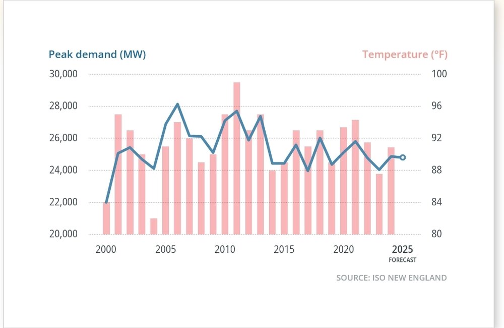
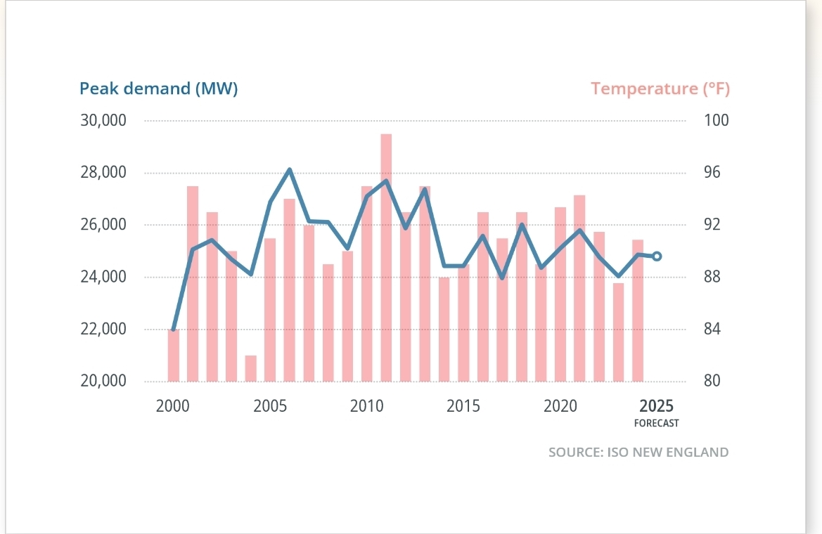
Will probably be some top demand day records next week for ISO New England, especially since the bulk of the heat is midweek. Anyone know how any of these top demand days compare to next week? The large drop in peak demand from 2013 on has been mainly due to residential solar deployment and energy efficiency gains.
-
Drought helps a lot as 2024 showed
-
And now it begins…..
-
I love Phoenix area, cheap houses, good food, beautiful landscapes and great weather!
-
. My subconscious is always looking for an excuse to lay around for a week during my busy season but this is definitely getting a little repetitive and starting a cut into my finances. The good news is the next few days might not disappoint and have Increasing. storm potential to look forward to.
-
1.03"
-
0z euro backed off into more typical “awful heat wave but not record breaking” with mid-upper 90s and maybe 1 100 day
-
This too, in a sense. If it's not going to storm in some fashion, then nice sunny days are good, too. A week of drizzle? No thanks.
-
65° / 64° feels gross with the wetness.
-

2025 Lawns & Gardens Thread. Making Lawns Great Again
BrianW replied to Damage In Tolland's topic in New England
Got a new driveway, drain and some stonework done. I don't mess around with seed especially on bare spots that will just turn to weeds. Sod is the way to go if you can afford it. You just roll out pristine KBG with zero weeds. The sign said this sod was from Savage Farms in Deerfield, MA.


-
Storm around 3am woke me up and dropped 0.4-0.5”
-
About .70” here but you probably did even better.
-
Another .58 over night. 1.75 in the last two days.
- Today
-
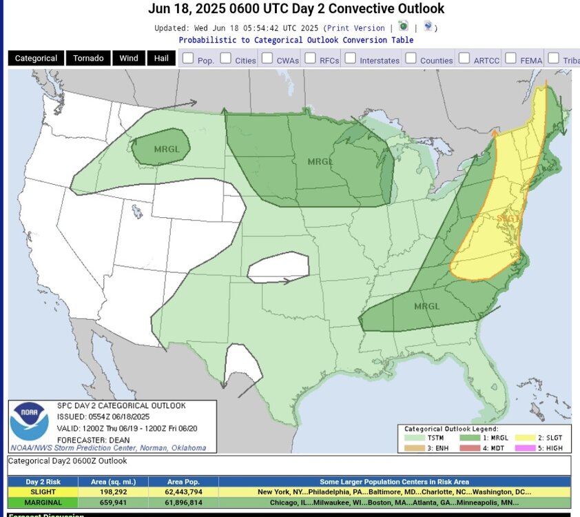
Slight risk probabilities stayed rock steady overnight for Thursday. ...New England into the Mid Atlantic/Southeast... Relatively rich low-level moisture will stream northward ahead of the front approaching New England and the Mid Atlantic during the day on Thursday. Moderate buoyancy may develop as far north asnorthern NY/VT, with pockets of stronger heating/destabilization farther south into the Mid Atlantic and Carolinas/Southeast. The strongest deep-layer flow/shear is still expected from PA/northern NJ northward into New England, where wind profiles will be conditionally supportive of supercells and organized bowing segments. Damaging winds and perhaps a tornado could accompany the strongest storms in this area. Farther south into the southern Mid Atlantic and Carolinas,deep-layer flow will be somewhat unidirectional and weaker, but still sufficient for some organized convection. Clusters capable of producing scattered wind damage will be possible, especially in areas where stronger diurnal heating/destabilization occurs. Deep-layer flow will be rather weak into parts of MS/AL/GA/SC, but the glancing influence of the mid/upper-level trough and relatively large MLCAPE and PW will support storms capable of producing isolated strong/damaging gusts. The full SPC forcast discussion for Thursday is in the link below. https://www.spc.noaa.gov/products/outlook/day2otlk.html
-
I completely understand. Mundane to me is a week straight of sunny days, clear blue sky's with just enough breeze to gently play the wind chime as the afternoon doves sing back and forth about their lifelong court ship. That bores the living daylights out of me. Call me strange but I spend those days dreaming of 100-degree weather with muggy nocturnal thunderstorms or digging two feet of snow out of my driveway after mud wrestling the female clown midgets and old Jack three legs from the Ringling Bros. and Barnum & Bailey Circus.
-
Incoming line in the distance for the Northern Eastern shore. Should hold together.
-
It’s starting to get a little sticky out there. After today’s showers and the rapidly changing airmass, I hope we all have a few extra pairs of shorts on hand. Many days of free balling lie ahead!
-
Healthy elevated convection right now.
-
Yea it is! Still going and the line has mostly pushed through. Looking at RadarScope seems to only be the southern end of the line with all the lightning.
-
lol it’s an absolute fireworks display rn
-
00z NAM and HRRR have explosive storm development just to my southwest around 21z tomorrow. Shades of 3/30/25 which produced 60-70 mph gusts and small tornadoes across N. Indiana and S. Michigan. The tree damage was significant across the area… and that was without leaves on the trees.
-
Had boomers for a bit, but .05” of rain. Desperately need a big time soaker
-
That line that I thought would not hold is slamming the back of the house right now. The lightning on it alone is intense. Wind driven rain. ETA Wow this is the loudest storm we have come through in quite awhile. Still packing a punch as the line stretched out. Lot of lightning.
-
Looks like I'm not missing anything too exciting back home so far.
-
Nice call. GFS and Euro hint right at that tonight.


.thumb.jpg.6a4895b2a43f87359e4e7d04a6fa0d14.jpg)