All Activity
- Past hour
-
WB 18Z GFS stays south again...the new Dr. No....

-
Been seeing them a lot this year. Prob once a week. My son hit (and killed unfortunately) a young male back driving in July. I think the population must be up because there are reports of them getting into trash in more developed areas around smith mtn lake as well. There's a ton of undisturbed forest around here so frequent sightings must be part of a population increase. Deer have definitely boomed and a few too many coyotes are running around. Coyotes are the only animals that I wish weren't around. They will kill dogs and our dog will chase anything lol. Bears stay clear of dogs
-

September 2025 OBS-Discussion centered NYC subforum
steve392 replied to wdrag's topic in New York City Metro
Any significant rain the rest of the month? -
Had a nice round of showers around 3, temps definitely cooled off after those cleared out.
-

September 2025 OBS-Discussion centered NYC subforum
winterwarlock replied to wdrag's topic in New York City Metro
84 back to back highs 10 of 14 days with 80 plus highs in September...summery and more to come -
September 2025 OBS-Discussion centered NYC subforum
steve392 replied to wdrag's topic in New York City Metro
78 and partly cloudy. Seems like a nice day if i were to get outside. -

September 2025 OBS-Discussion centered NYC subforum
Roger Smith replied to wdrag's topic in New York City Metro
Potential is one thing but reality seems to be global blanding at least in the mid-latitudes. I can't remember as much boring weather as we've seen in the past five years. To my way of thinking, adding extra cloud, moisture and heat to all air masses is a recipe for less rather than more cyclogenesis. Everywhere is becoming Vladivostok. -
That’s awesome. They’re around in Frederick as well, but haven’t seen one biking yet…though did see one scurry across Hamburg Rd a couple years ago. Might have been the one that had been recently released.
-

September 2025 OBS-Discussion centered NYC subforum
donsutherland1 replied to wdrag's topic in New York City Metro
Temperatures will top out in the upper 70s to perhaps lower 80s tomorrow and then the lower to middle 70s on Tuesday and Wednesday. Readings will likely return to the upper 70s on Thursday and the lower 80s on Friday. Cooler air should return for the weekend. In terms of near-term precipitation, a cutoff system near the Delmarva could bring some showers or a period of rain on Wednesday into Thursday. Parts of the Delmarva and Jersey Shore will likely see the heaviest amounts. September 1-15 remains on track to achieve a solid cool anomaly. Since 2000, there have been nine years that saw a cooler than normal first half of September. Two-thirds of those years went on to record a warmer than normal second half of September. Only two of those years (2017 and 2019) wound up with a monthly mean temperature of 70.0° or above. Overall, for two-thirds of those years, the cool start was sufficiently cool to produce a cooler than normal monthly anomaly. The last year that saw both a cooler than normal first half and second half of September was 2009. Prior to that, it was 2001. The last year to record a cooler than normal first half of September followed by a warmer than normal September was 2024. The ENSO Region 1+2 anomaly was -0.3°C and the Region 3.4 anomaly was -0.4°C for the week centered around August 27. For the past six weeks, the ENSO Region 1+2 anomaly has averaged +0.33°C and the ENSO Region 3.4 anomaly has averaged -0.32°C. La Niña conditions will likely develop during mid- or late-autumn. The SOI was -9.21 yesterday. The preliminary Arctic Oscillation (AO) was -0.079 today. Based on sensitivity analysis applied to the latest guidance, there is an implied near 56% probability that New York City will have a cooler than normal September (1991-2020 normal). September will likely finish with a mean temperature near 68.9° (0.3° below normal). Supplemental Information: The projected mean would be 0.9° above the 1981-2010 normal monthly value. -
Decided to take a walk this morning along the C&O Canal park. Temp was just right with a slight breeze.
- Today
-
Beer?
-
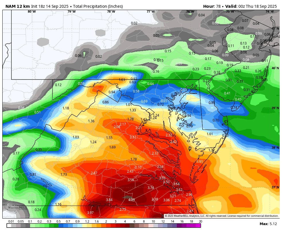
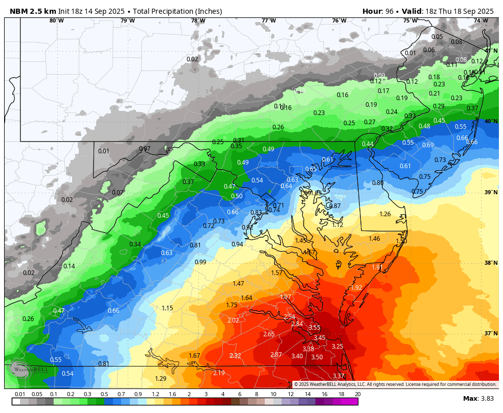
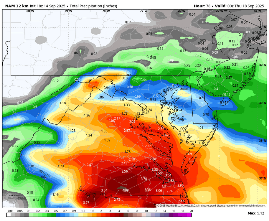
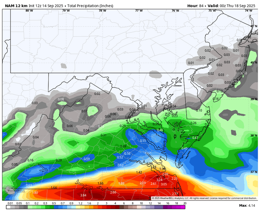
WB 18Z NAM for what it is worth at this range, big shift north compared to 12z.
-
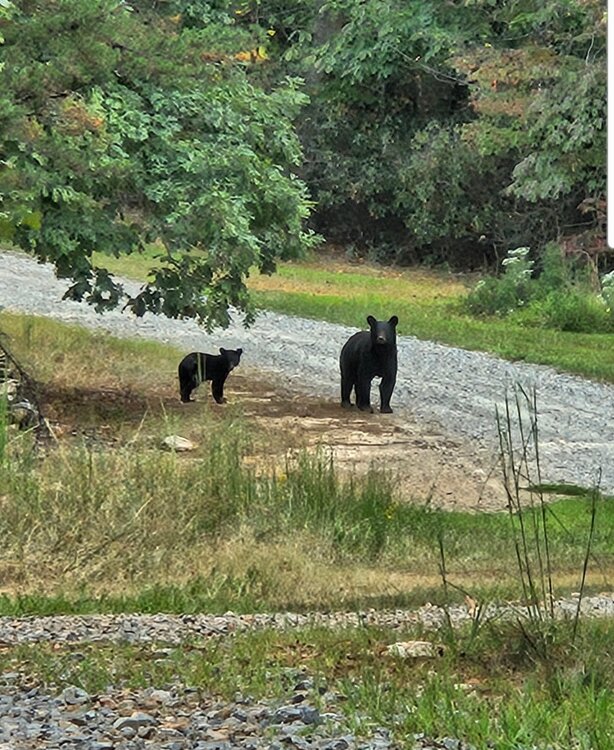
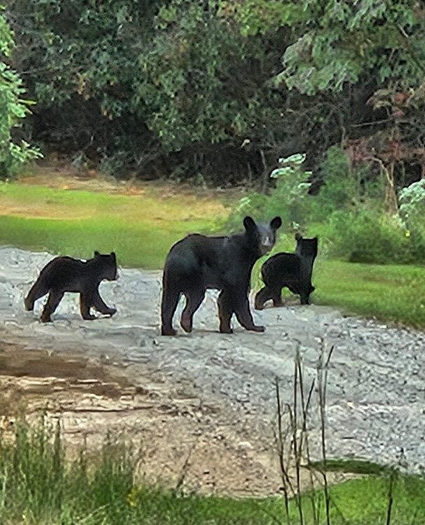
Great outdoor work wx but it's a dry dust bowl lol. Ran into a mom and some cubs today. There were 3 cubs but could only get 2 in a pic. I was about 100yds away. Black bears around here are curious but keep their distance... thankfully... lol
-

September 2025 OBS-Discussion centered NYC subforum
Sundog replied to wdrag's topic in New York City Metro
The potential is there for more intense systems. Theres a straightforward relationship between energy and intensity. That doesn't mean that intensity will be realized or there won't be other factors that hamper the realization of that intensity. -

September 2025 OBS-Discussion centered NYC subforum
MANDA replied to wdrag's topic in New York City Metro
Data at my location. Y.T.D. = 33.56" 12 month 9/14/24 - 9/14/25 = 43.01" Wetter than all of the above climo stations. -
one just moved through here, quick drink
-
Excellent. Thanks
-
September 2025 OBS-Discussion centered NYC subforum
Roger Smith replied to wdrag's topic in New York City Metro
Some details about evolution of the Great Atlantic Hurricane weather pattern. Aug 1944 had been very hot in the east, and this continued into early September. In fact NYC set a record 97F on Sep 2nd that was later erased by the 102F in 1953. It was 94F on the 3rd and 90F on the 5th. No measurable rain fell from Aug 23 to Sep 11 (a 20 day dry spell) ... Cooler air masses arrived thereafter and were in place when the G.A.H. ran up the east coast. A very warm day followed the passage of the core offshore, in strong southwest to west winds on Sep 15th as shown below ... NYC obs Sep 12 to 18 1944 Date ___ Max _ Min __ rain 09 12 ___ 72 __ 63 ___ 1.64 09 13 ___ 74 __ 66 ___ 3.94 09 14 ___ 78 __ 65 ___ 3.82 09 15 ___ 86 __ 70 ___ Tr 09 16 ___ 84 __ 66 ___ 0.00 09 17 ___ 80 __ 63 ___ 0.00 09 18 ___ 73 __ 63 ___ 0.00 09 19 ___ 69 __ 64 ___ 0.09 Weather maps show the G.A.H. at these locations: Sep 13 1944 n.e Bahamas Sep 14 1944 near C Hatteras 12z to s.e. Long Island Sep 15 1944 across Cape Cod into Bay of Fundy (rapidly weakening to TS) Sep 16 1944 absorbed by northern low near e Nfld The 9.40" of rain that fell Sep 12-14 represented 90% of the month's rain (0.77" fell on 28th), and another 14 day dry spell followed Sep 29 to Oct 12 during which another record high was set (88F on Oct 7, 1944). And they say climate change is making the weather more intense. S-u-u-re. -
Hmm, where have I seen this movie before? Oh, that's right, every fall since 2007.
-
Fair enough, the latitude of being NoP is definitely crucial along with not being in the valley anymore. Hope you break 100" this year!
-

2025-2026 ENSO
Daniel Boone replied to 40/70 Benchmark's topic in Weather Forecasting and Discussion
Lol. Can't believe I did that ! Should wear my Reader's. Big Thumbs don't work too well texting. -

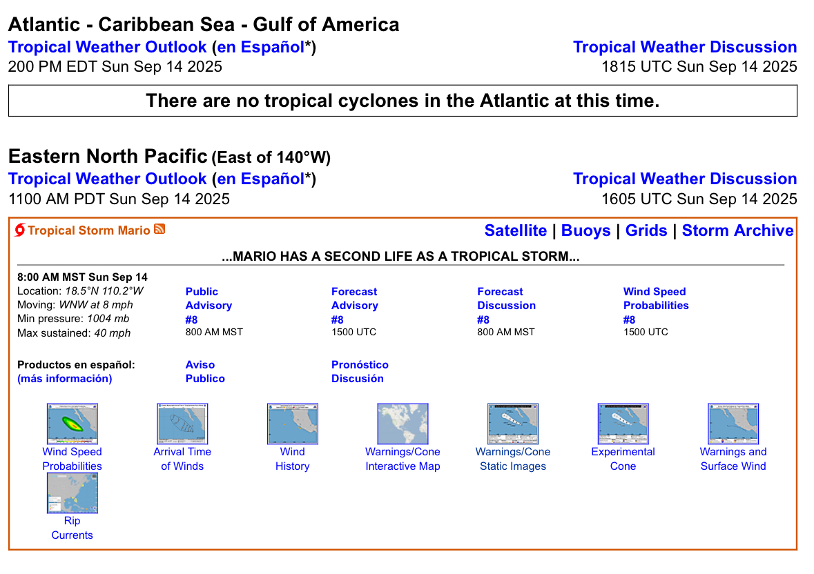
Central & Eastern Pacific Thread
gallopinggertie replied to Windspeed's topic in Tropical Headquarters
He came back from the dead! I love when the NHC has a sense of humor lol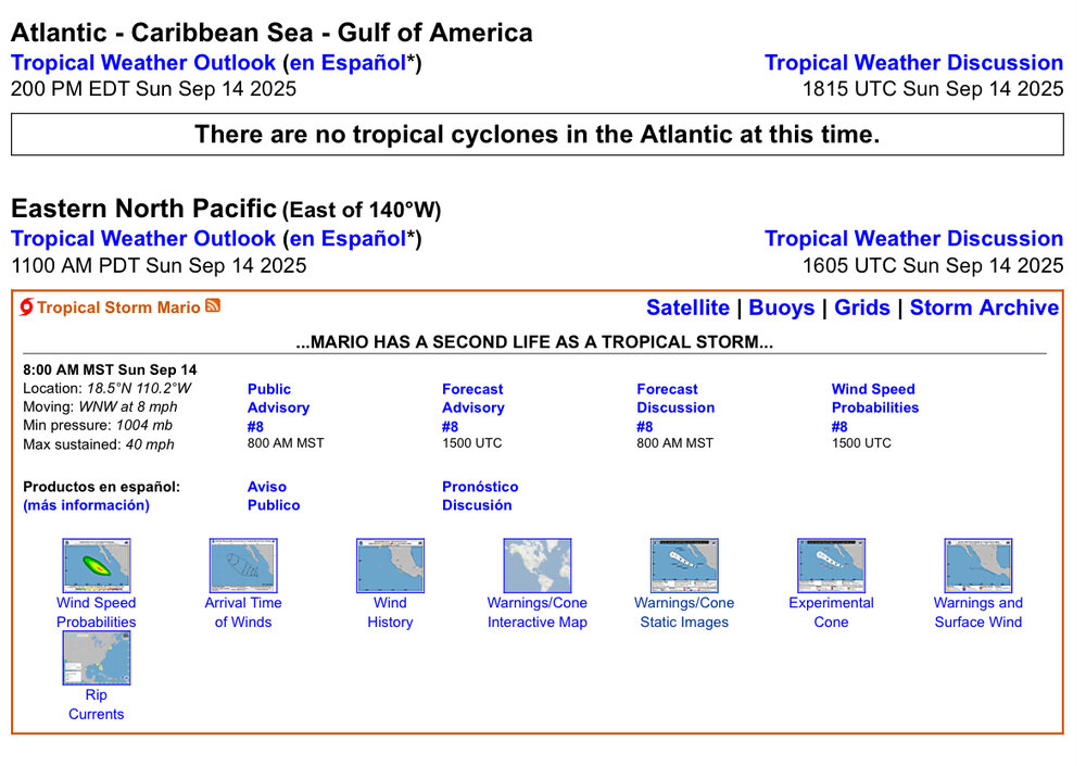
-
WB 18Z NBM at Day 4

-
One trend I've noticed in the past 20 years is we just can't hold a neutral enso, which is ultimately what we all want for winter in this sub. Just when we thought it was gonna happen, La shit head pops back up to give a screaming pacific jet for the late fall/early winter weather. Just sucks. La Nina/El Nino have always been a thing, but the frequency has definitely changed. Curious.
-
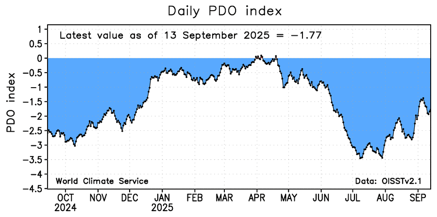
After waiting 2 1/2 weeks for the daily WCS PDO to update, it FINALLY updated today! A lot has been happening since. As of the previous update, it had bounced back down some to ~-2.75 after having risen a lot to ~-2.0 ~ten days earlier. Since then, it rose back up steeply to ~-1.5 on Sept 6th. Then it fell back some to ~-1.95 on Sept 11th. It rose back some since to the -1.77 shown below for Sept 13th. As a reminder the comparable NOAA daily would likely be ~~-2.75, which itself represents a steep climb from the daily lows near -4.5 in July: