All Activity
- Past hour
-
 If you love clouds, you will love the current satellite loop: https://www.star.nesdis.noaa.gov/GOES/sector_band.php?sat=G16§or=ne&band=GEOCOLOR&length=12
 -
I think this year it's worse here. Here was a year ago.
-
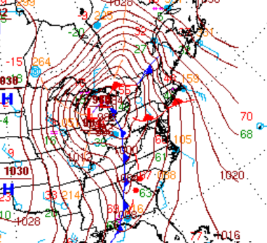
 643 ACUS11 KWNS 161404 SWOMCD SPC MCD 161403 MDZ000-VAZ000-DCZ000-WVZ000-161630- Mesoscale Discussion 0269 NWS Storm Prediction Center Norman OK 0903 AM CDT Mon Mar 16 2026 Areas affected...Central Virginia into Maryland Concerning...Severe potential...Watch possible Valid 161403Z - 161630Z Probability of Watch Issuance...60 percent SUMMARY...The severe weather threat will increase through the morning. DISCUSSION...Low-level moisture advection and cooling mid-level temperatures will continue to destabilize Virginia into Maryland this morning. Limited capping evident on the RNK and IAD 12Z RAOBs has resulted in scattered warm sector development ahead of the primary squall line. These messy-mode storms will continue to limit heating, but may have some severe threat as above mentioned destabilization continues within a strong wind profile. Low-level shear, already strong at 12Z, will continue to strengthen through the day. Therefore, any stronger/deeper updrafts could have some tornado threat late this morning into the early afternoon. The primary threat still appears to be the wind/embedded tornado threat later this afternoon as the secondary mid-level jet streak ejects east of the Appalachians and wind fields strengthen rapidly. However, even this threat is contingent on the evolution of these morning storms. A tornado watch will likely be needed at some point, potentially by later this morning if the morning storms start to show more organization/structure. ..Bentley/Thompson.. 03/16/2026 ATTN...WFO...PHI...AKQ...LWX...RNK...
 -
 I mean just stating that the stuff moving in a couple hours isn’t exactly ideal for getting severe. Early storms will limit what we can see.
 -
 Sun peeking through even with rain showers here in southern PG county
 -
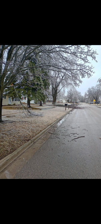
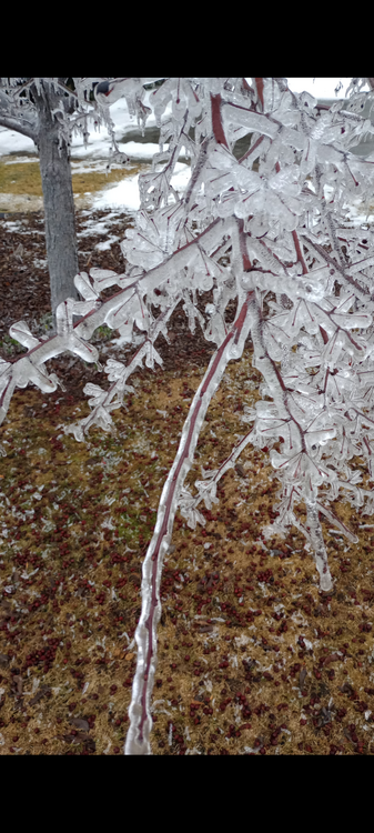
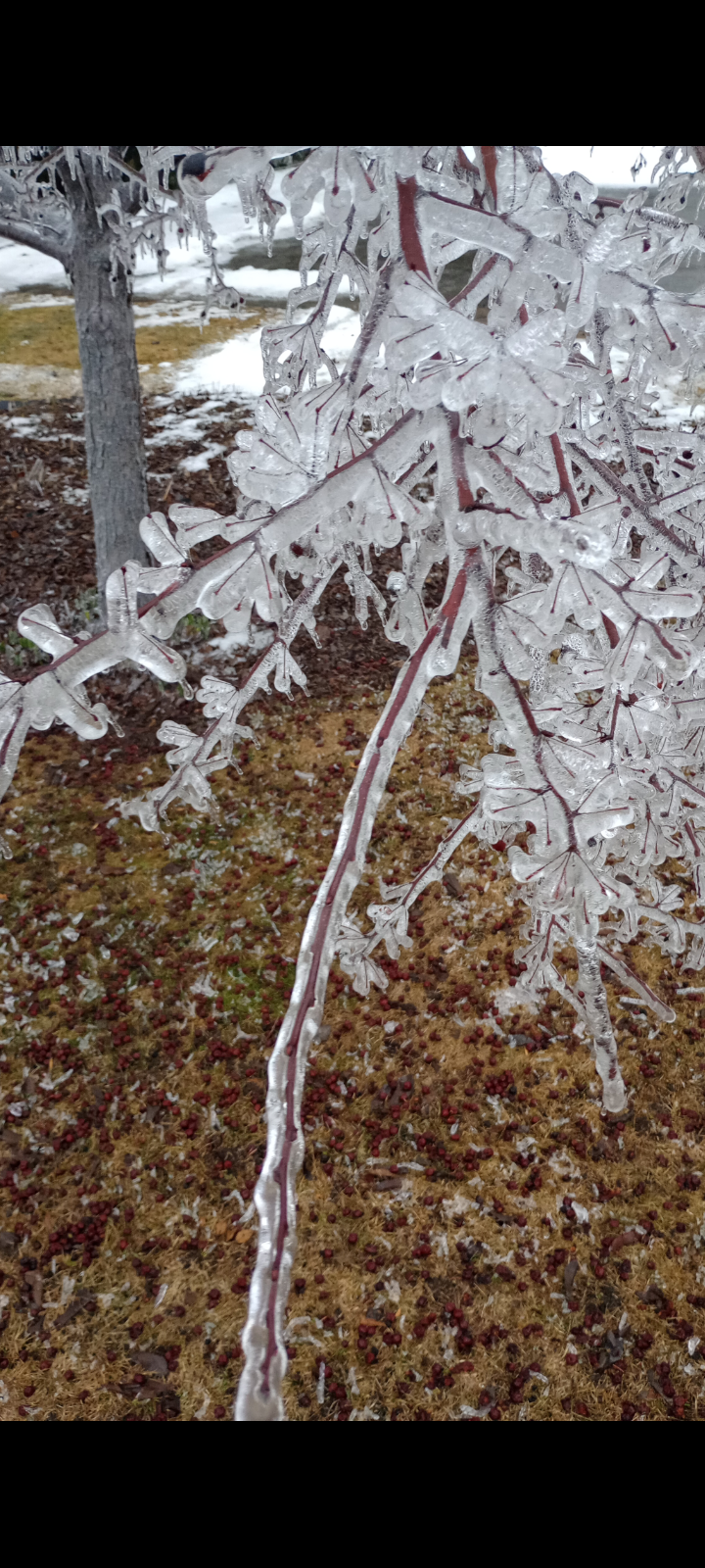
Models look solid for Buncombe. If it snows heavy enough we could get an inch or 2 in the city I think.
.thumb.png.a9b302ad583c032e5e9b29d5aea81e57.png)
.thumb.png.9d1725f6364e26086af7319bb1019fc0.png)
-
 sun coming out under the cloud deck in rehoboth
 -
Already a STW up to Culpeper
-

Pittsburgh/Western PA WINTER ‘25/‘26
colonel717 replied to Burghblizz's topic in Upstate New York/Pennsylvania
-

Central PA Spring 2026 Discussion/Obs Thread
WmsptWx replied to Voyager's topic in Upstate New York/Pennsylvania
Max Velocity is a degreed meteorologist. Ryan Hall went to Mississippi State for meteorology but didn't graduate, worked in TV weather, and presents weather along with a very, very good met in Andy Hill. There is very little wrong with what these two do. -
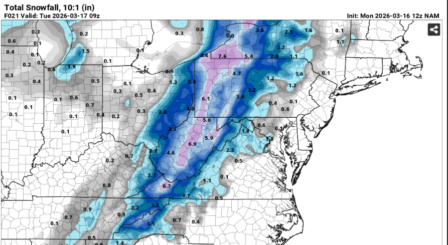
14-16” reports down in Red Wing where my ski hill is. Think I’ll “work from home” today…
-
It’ll be 60 soon . Already 53 and soaring with winds . Wild one ahead
-
Kind of a yikes here by the Euro, no idea why it was so off-base with this event (though some other models were pretty bad too).
-
Central PA Spring 2026 Discussion/Obs Thread
WmsptWx replied to Voyager's topic in Upstate New York/Pennsylvania
Brad Sweitzer, Sr., is the guy who runs the organization. He's best known for defrauding a Northwest Savings Bank and Loan out of $5600 before heading to North Carolina to chase a hurricane. The bank cried "fraud," and called the opps. Sweitzer cried "bounced cheque," and he ended up doing three years probation for it. They ban people who call them out on social media or disagree. Apparently yesterday's "People who are living and well reading this will die tomorrow," headline was so incendiary that they edited the post but did not backtrack from the headline because "it is true." It looks like in some parts of the area, a Winter Weather Advisory is more likely to be issued than a Severe Thunderstorm Warning, and if that happens, I plan to send a screenshot of the headline to every company they do business with along with a link to State College NWS as a direct to an actual authority. -
 Little peeks of sunshine here. But too much crappy low grade convection polluting the warm sector now, especially in the east. Some is okay ofc, because ideally you don't want your LCLs too high, but still need a corridor of at least some halfway decent destabilization ahead of this afternoon's activity.
 -
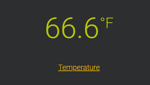
 64 degrees with a similar dewpoint in Colesville, MD (but I'm at the office right now in Potomac)
 -
I mean, I called for a warm March and April in early February. The cold was on borrowed time. We never get more than 3 straight months of well below average temperatures anymore. The last time was in January-March 2015. Then, things turned warmer in April and May had close to record warmth. 4 straight well below average temperature months is just about impossible, especially in this warming climate.
-
-
 UVA canceled classes after 11am. Time to start deciding if I’m chasing.
- 394 replies
-
- 1
-

-
- severe
- thunderstorms
- (and 1 more)
-
Dense fog still holding on here. 61 F, DP 60 F.
-
RIP Roger.
-
 Was about to say sky is brighter but ya’ll are on it. 61/60, when does the snow start??
- 394 replies
-
- 2
-

-

-
- severe
- thunderstorms
- (and 1 more)


.png.a082e5b27f7351d2afc24221dc2e0c3b.png)
.png.769f3047c230d17bb167257bba5cc382.png)