All Activity
- Past hour
-
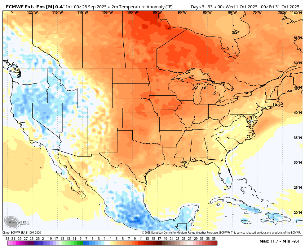
What a worthless piece of fake long range forecasting... If it were as simple as using sst anomalies to predict the winter jet stream pattern, every winter forecast would be perfect! It's all modelology with no meteorology. All click bait; headline stating a brutal winter lies ahead, but almost zero support discussed in the video. So typical of today's social media driven weather industry.
-
Thanks Humberto
-

2025-2026 ENSO
so_whats_happening replied to 40/70 Benchmark's topic in Weather Forecasting and Discussion
We peaked earlier this year with the extreme -PDO so the runway is a little bit better.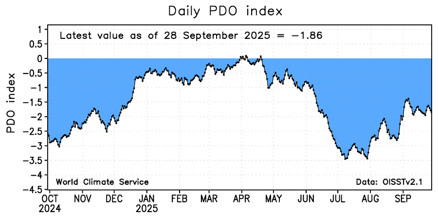
-

- Today
-
I'm sure the models will be right but I hope they're wrong.
-

September 2025 OBS-Discussion centered NYC subforum
LibertyBell replied to wdrag's topic in New York City Metro
The gradation is even finer than that. Many times the sea breeze never makes it north of the barrier islands and the south shore is the hottest place. This is what happened in late June. -

2025-2026 Fall/Winter Mountain Thread
Maggie Valley Steve replied to Buckethead's topic in Southeastern States
We've been in the clouds all day with the Wedge firmly established. Drizzle has returned in earnest this evening in the Valley. I had a high of 69 today and a low this morning of 58. Thanks for sharing your amazing pictures Timm! I always look forward to you sharing! -

September 2025 OBS-Discussion centered NYC subforum
jm1220 replied to wdrag's topic in New York City Metro
This time of year after the water warms up the south shore isn't much cooler anymore if at all. Also the last few summers the seabreeze just brought more humidity even if temp went down a few degrees, so no relief. You're also still well away from the barrier islands. -

September 2025 OBS-Discussion centered NYC subforum
psv88 replied to wdrag's topic in New York City Metro
That plus north winds which make the north shore cooler. I have a cool app for the boat called predict wind. Micro level wind forecasts which show how in the summer three general wind zones. North shore, mid island and south shore. Mid island bounces back and forth between north shore and south shore wind directions, when the other 2 can remain steady -
Here's a couple from my game camera in the wood yard. The deer were loving the rain . Not me...
-
Yeah not nearly as crisp a satellite presentation as even a few hours ago. FL winds continue to increase however.
-
Youtubers gone wild....
-

September 2025 OBS-Discussion centered NYC subforum
SACRUS replied to wdrag's topic in New York City Metro
Highs PHL: 81 EWR: 80 TEB: 79 ISP: 79 TTN: 79 New Brnswck: 78 JFK: 78 ACY: 77 NYC: 77 BLM: 75 LGA: 75 -
Imelda has a great outflow channel to the north, but it appears to be fighting dry air. Convection within the core is looking a bit ragged this evening.
-
Hands felt like 2 ballons?
-
September 2025 OBS-Discussion centered NYC subforum
LibertyBell replied to wdrag's topic in New York City Metro
lol this summer we were 100+ even on a seabreeze. -
September 2025 OBS-Discussion centered NYC subforum
LibertyBell replied to wdrag's topic in New York City Metro
the sun came out here for a bit too but it hit 81 here even when it was cloudy. -

September 2025 OBS-Discussion centered NYC subforum
Sundog replied to wdrag's topic in New York City Metro
You moved south at a time when the water is now extra toasty so your cooling seabreezes aren't what they used to be. -
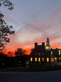
Amazing sunset here too. The entire sky was pink.
-
Our daughter sent us this from S VT
- Yesterday
-
dews dropped from being 78-80 for the past 3 days to an astounding 74 this evening. KAMX radar shows a band of storms over the everglades near I-75 west. Clouds were moving fast today.
-

2025-2026 Fall/Winter Mountain Thread
Buckethead replied to Buckethead's topic in Southeastern States
I saw the easterly flow showers pop up late yesterday and decided to stand in the rain and hope for a nice shot at sundown. The fog cleared just in time for this. Currently 54 with showers in Wolf. Sent from my SM-S908U using Tapatalk -
September 2025 OBS-Discussion centered NYC subforum
psv88 replied to wdrag's topic in New York City Metro
Yep. Long lsland microclimate is crazy. Moving south I thought I’d always be cooler in summer but it’s not the case at all. Some days yes some days no, but it often evens out. in winter I’m expecting lots of suckage in south Commack in marginal events. -
The greatest sunset I'll probably ever see came as I was chasing Dorian in NC. The sky was on fire. There have been some good ones up here, but tonight was spectacular. The picture doesn't even do it justice.
-
Probably on the cusp of hurricane status now. Recon in there now.