All Activity
- Past hour
-
Here’s the 06z OP run,
-
Lots of meh members on the gefs
-
100% correct. Possible, but the 12-2 system has the deck stacked against it. No 50-50 low, no Lakes to New England H.P. as a cold air source. And of course, our long time drought pattern that no one fully understands is again an aggravating factor. The GFS dropped the QPF from 1.48" for Augusta at 06 11-27 to .60" at 06 11-28. I don't have enough fingers to count how many times this has happened during the past 4 months.
-
Looks like the last 4 seasons continue. At least days get longer in a few weeks.
-

December 2025 regional war/obs/disco thread
moneypitmike replied to Torch Tiger's topic in New England
Are you able to post any pics, Jeff or is that forbidden? -
This set-up would probably work in January with a colder antecedent air mass. Track isn't bad. Fast flow doesn't allow low to amp up and move inland.
-
Not really. Elevation won’t matter much.
-
Skynet still fairly flat…and consistent. No spiking footballs yet. We ride the ensembles.
-
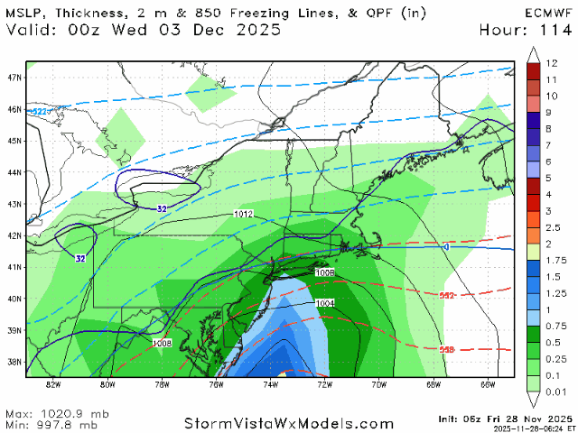
06z Euro starting to tick a bit further north, SLP down to 980mb as it makes its pass by, Decent hit in the interior of SNE/CNE.
-
6z euro still looks on for northwest crew.
-

December 2025 regional war/obs/disco thread
Damage In Tolland replied to Torch Tiger's topic in New England
Somewhat of an elevation event . At least in that depiction -

Pittsburgh PA Fall 2025 Thread
blackngoldrules replied to TheClimateChanger's topic in Upstate New York/Pennsylvania
I don't know how this next system is going to turn out for us, but at least we already have something to track. GFS gives the weenie amounts while Euro gives us little. Others are somewhere in between the two. Should be interesting to see how this one evolves. I'm also just trying to get the page more active again. Lol Sent from my SM-S931U using Tapatalk -
I'll take the GFS. I'm one of the few who doesn't want snow. Euro has me in the bullseye. Maybe you can rent old pit westborough.
-
Yep Typical
-
Nothing burger unless you live 45+ Miles NW of nyc.
- Today
-

December 2025 regional war/obs/disco thread
Snowcrazed71 replied to Torch Tiger's topic in New England
Ok.. I'm still not going to kill this for us in Connecticut. The GFS could be easily shift back down 50 miles or more and we are back in the game. Today is Friday and we still have 5 days before this storm gets here. This is not the final outcome. Not yet. -
December 2025 regional war/obs/disco thread
moneypitmike replied to Torch Tiger's topic in New England
yes please, GFS. EC would disappoint central and northern folks. -
Gefs slightly more east and colder. Nice interior storm.
-
6z GFS gone wild here
-
Ceres has updated through September. Net radiation continues to increase off the enso bottom and the 12-month average is getting close to peak levels in La Ninas before 2020.

-
December 2025 regional war/obs/disco thread
moneypitmike replied to Torch Tiger's topic in New England
Just reading the words makes me happy. Monday Night Mostly cloudy, with a low around 18. Tuesday A 40 percent chance of snow after 1pm. Cloudy, with a high near 35. Tuesday Night A 50 percent chance of snow. Mostly cloudy, with a low around 21. -
Have had 3 inches of snow here past two days, not a big storm but looks like long-lasting snow cover with colder temperatures developing. Around 28 F now as the snow pulls away to southeast.
-

November 2025 general discussions and probable topic derailings ...
ineedsnow replied to Typhoon Tip's topic in New England
Driving to cumberland farms this morning and realized they pre treated roads.. they must have been on the board -

Nov 28-30th Post Turkey Day Wintry Potential
jlauderdal replied to Chicago Storm's topic in Lakes/Ohio Valley
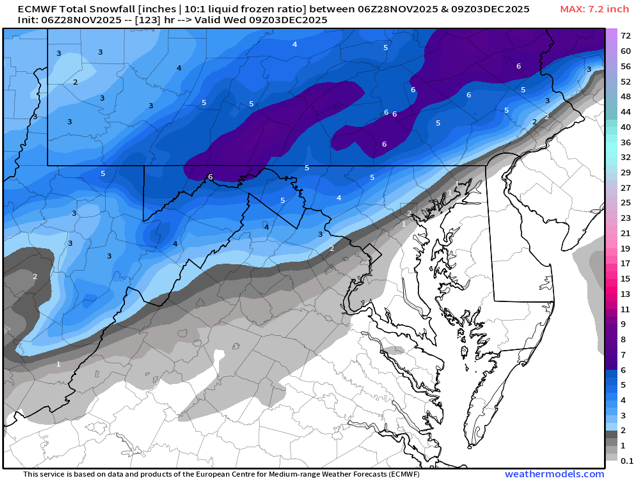
Upping my 7.5 Downers Grove prediction to 9 just for Baum who is right down the road. We got this Baum, 9 and a decent possibility of overachieving. Just have to watch the euro, its not giving up on the more northerly route of the low and Euro AI has the low a tick farther north than the Euro OP. -

Nov 28-30th Post Turkey Day Wintry Potential
Mogget replied to Chicago Storm's topic in Lakes/Ohio Valley
Winter Storm Warnings in southern Wisconsin. Once it gets light, better go check on the snow blower, which makes a nice change from the last couple of years.


