All Activity
- Past hour
-

2026-2027 Record-breaking El Nino
mitchnick replied to Stormchaserchuck1's topic in Weather Forecasting and Discussion
That map I posted was the run-to-run change between September and October Euro seasonal. The actual snowfall anomaly map is above and that shows AN in that location. -
Euro AI ens maintains a +NAO through most of its run, may be able to shock this winter back to life
-
Absolutely all relative. I love arctic cold. Last winter was great even without heavy total snowfall. It was cold, frozen and white. Often times the "warm" spells in strong ninos here is damp overcast with highs 37-40°, which is more uncomfortable imo than dry cold at 0°. An active pattern should hopefully promote a temp rollercoaster even though it ends up mild in the mean.
-
I think areas closer to the Blue Ridge will do well due to the flow from the SE/uplift but there could be a precip minima near the I-77 corridor or a little east of there.
-
I mean it’s all relative. It could be +10F for winter here and it’d still be too cold for me. 1877-1878 in DLH Dec +15.6F Jan +9.3F Feb +15.6F (yes same dep as Dec) Mar +11.8F Roughly +13F for DJFM is pretty wild
-
DOGE-level inanity
-
Yep. I was feeling optimistic about the Greenville area finally getting some decent rain until I read that tidbit from the GSP NWS.
-

2026-2027 Fall/Winter Mountain Thread
Maggie Valley Steve replied to BlueRidgeFolklore's topic in Southeastern States
The 5PM Update shows Isaias stronger with sustained winds of 65. Tropical Storm Force wind extend out 60 miles from the center. The track was adjusted further E giving a nod to the AI guidance.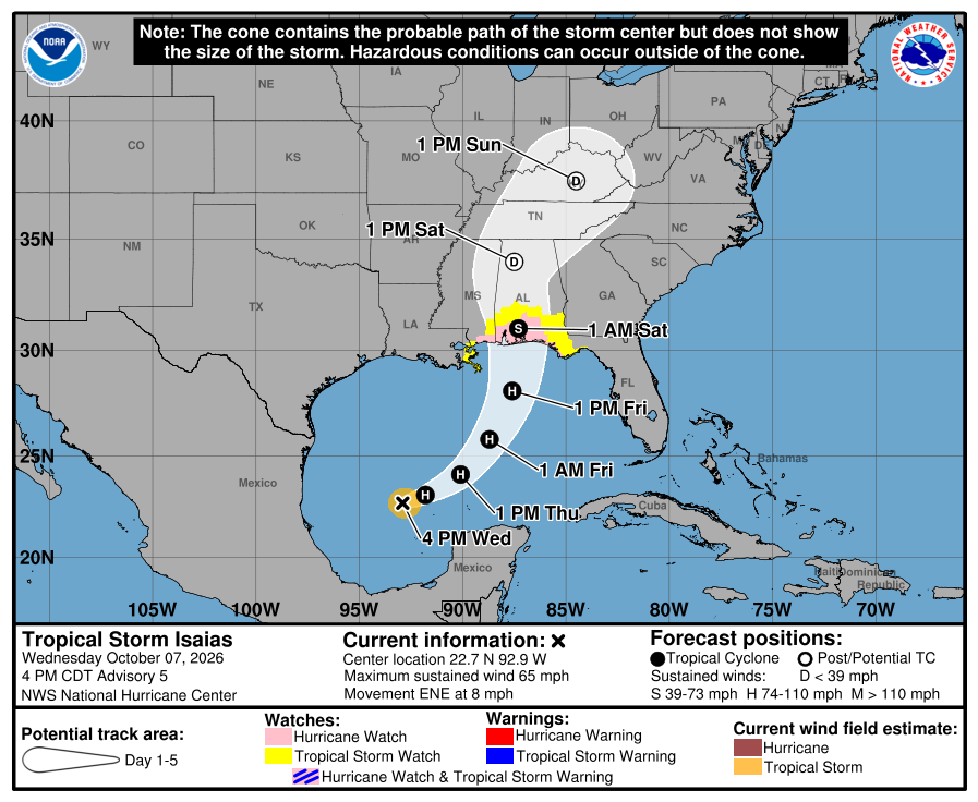
-
 http://indocureglobal.com/# prescription drugs from india
 -
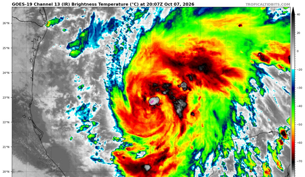
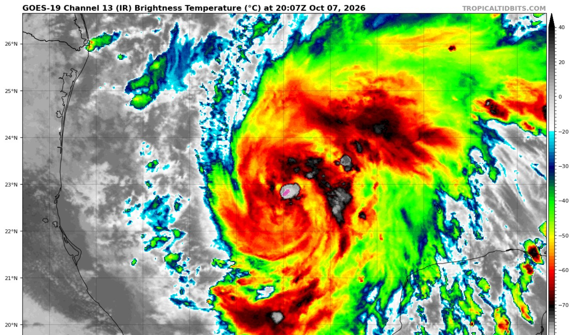
Tropical Storm Isaias Discussion Number 5 NWS National Hurricane Center Miami FL AL092026 400 PM CDT Wed Oct 07 2026 Satellite and aircraft data show that Isaias continues to strengthen. GOES-19 imagery indicates that a central dense overcast has formed, and the system has become more symmetric than this morning. The peak NOAA Hurricane Hunter aircraft 700-mb winds were 61 kt, with the pressure dropping to 994 mb. The initial intensity is set to 55 kt as a reflection of this data. Isaias is basically on track, moving east-northeast at 7 kt. There is no change to the synoptic reasoning as a deepening trough along the northwestern Gulf Coast and a strengthening Atlantic subtropical ridge should cause the system to move faster to the northeast tomorrow and northward on Friday. As long as the cyclone remains intact, it makes physical sense that the system will move on the faster and eastward side of the guidance due to the stronger shear Isaias should encounter near landfall. Thus, the new forecast is adjusted slightly to the east, closer to the AI-based and corrected-consensus models. NOAA radar data (P3-TDR) show that the system is experiencing some southwesterly shear, with tilt analyses displaying the mid-level circulation displaced 5-10 n mi to the northeast of the low-level center. This structure seems sufficient for further intensification given a continuation of similar low or moderate shear and very warm SSTs in a very humid environment. Models are fairly consistent about the shear increasing on Friday, but almost all guidance still shows a category 1 or 2 hurricane at landfall. While the regional hurricane models have generally come down on the peak intensity this cycle, it is unknown whether this is the start of a real trend, and we would prefer to see more than one guidance cycle before making any adjustments. The new forecast is close to the previous one, near the high side of the model suite. Key Messages: 1. Isaias is expected to strengthen and be a strong hurricane when it approaches the northern Gulf Coast on Friday. There is an increasing risk of life-threatening storm surge along portions of the northern Gulf Coast, and a Storm Surge Watch is in effect from The Mouth of the Mississippi River to Yankeetown, Florida. Residents in the watch area should follow advice given by local officials and evacuate if told to do so. 2. The risk of damaging hurricane-force winds is increasing over portions of the Florida Panhandle, southern Alabama, and southern Mississippi. A Hurricane Watch has been issued from Bay St. Louis, Mississippi, to Indian Pass, Florida. Residents in these areas should prepare for the possibility of long-duration power outages. 3. Isaias will bring areas of heavy rainfall to the central U.S. Gulf Coast and much of the Southeast Friday into the weekend. Flash and urban flooding, along with isolated river flooding, will be possible. 4. Isaias could bring gusty winds and areas of heavy rain to the western portion of the Yucatan Peninsula through Thursday. FORECAST POSITIONS AND MAX WINDS INIT 07/2100Z 22.7N 92.9W 55 KT 65 MPH 12H 08/0600Z 23.1N 91.8W 70 KT 80 MPH 24H 08/1800Z 24.1N 90.1W 80 KT 90 MPH 36H 09/0600Z 25.8N 88.7W 90 KT 105 MPH 48H 09/1800Z 28.1N 87.6W 95 KT 110 MPH 60H 10/0600Z 31.0N 87.3W 60 KT 70 MPH...INLAND 72H 10/1800Z 34.0N 87.5W 30 KT 35 MPH...POST-TROP/INLAND 96H 11/1800Z 37.5N 84.5W 15 KT 15 MPH...POST-TROP/INLAND 120H 12/1800Z...DISSIPATED $$ Forecaster Blake
-
BULLETIN Tropical Storm Isaias Advisory Number 5 NWS National Hurricane Center Miami FL AL092026 400 PM CDT Wed Oct 07 2026 ...ISAIAS QUICKLY INTENSIFYING, FORECAST TO BE A HURRICANE BY THURSDAY MORNING... SUMMARY OF 400 PM CDT...2100 UTC...INFORMATION ---------------------------------------------- LOCATION...22.7N 92.9W ABOUT 225 MI...365 KM WNW OF PROGRESO MEXICO ABOUT 500 MI...805 KM SSW OF THE MOUTH OF THE MISSISSIPPI RIVER MAXIMUM SUSTAINED WINDS...65 MPH...100 KM/H PRESENT MOVEMENT...ENE OR 65 DEGREES AT 8 MPH...13 KM/H MINIMUM CENTRAL PRESSURE...994 MB...29.36 INCHES WATCHES AND WARNINGS -------------------- CHANGES WITH THIS ADVISORY: None SUMMARY OF WATCHES AND WARNINGS IN EFFECT: A Storm Surge Watch is in effect for... * Mouth of the Mississippi River to Yankeetown A Hurricane Watch is in effect for... * Bay St. Louis to Indian Pass A Tropical Storm Watch is in effect for... * Jefferson/Plaquemines Parish line to west of Bay St. Louis * East of Indian Pass to Aucilla River
-
.thumb.jpg.a628c2147efdff1c820341d5143d9237.jpg)
2026-2027 Record-breaking El Nino
KChuck replied to Stormchaserchuck1's topic in Weather Forecasting and Discussion
What's with the snow hole in central North Carolina??? -
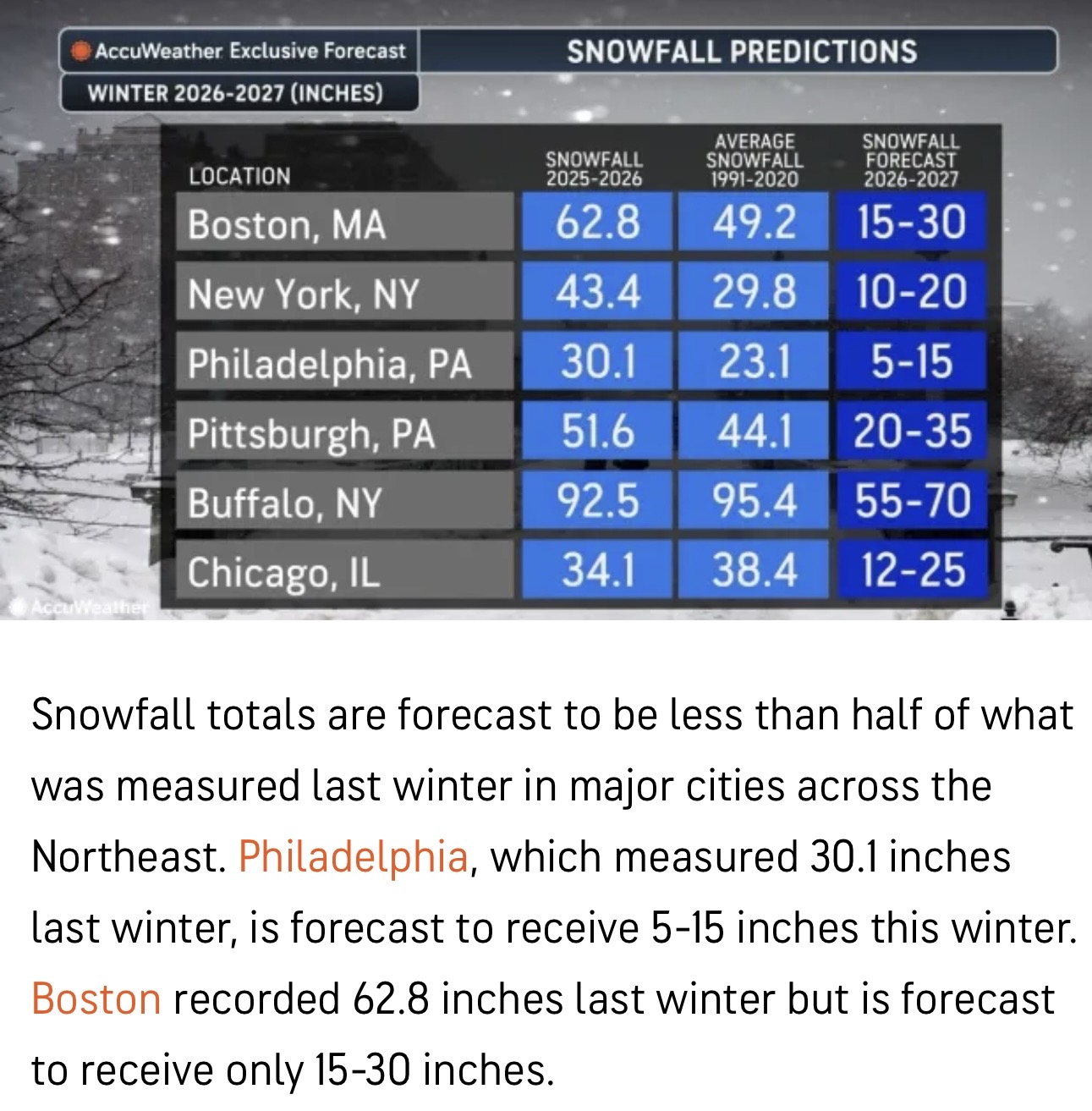
Saw this fun little graphic at Accuweather. 15”-30” for Boston?
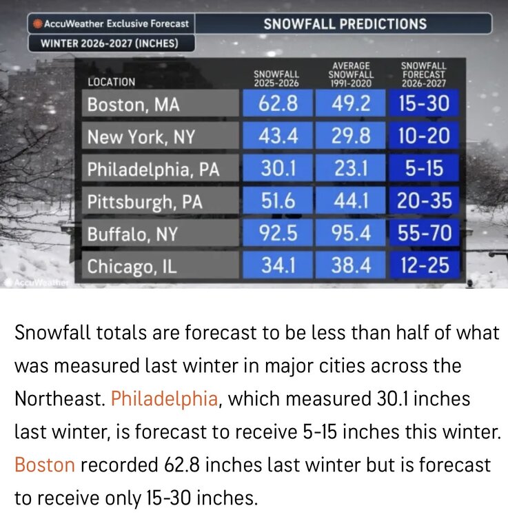
-
Looks like it's redeveloping to off the coast.
-
High of 71.5 after chilly low of 44 got down to 37.5 at Frederick house
-
https://omnirxdirect.shop/# medicine online
-
I never want to hear anyone say this is an “interesting weather free zone” ever again.
-
100%
-

2026-2027 Record-breaking El Nino
GaWx replied to Stormchaserchuck1's topic in Weather Forecasting and Discussion
Please post banter or garbage here: -
Any year now I'm expecting tarantulas and scorpions to be roaming SNE! Lol
-
Maybe they’re saving cap space so we can get two more relievers that should be in the Charlie Brown league.
- Today
-
Popping towers but definitely looks like its ingested some dry air over the past couple hours.
-
Post banter here so readers of the main El Niño thread will be able to locate the good quality posts without having to sift through lots of garbage to find them.
-
Ughhhhh I knew this was bound to happen. They’re just getting bigger and deadlier here. Adapting to our climate and just relocating from other areas. https://www.wtnh.com/news/connecticut/new-haven/venomous-spider-species-documented-in-connecticut-for-the-first-time/?utm_medium=social&utm_source=facebook_WTNH_News_8&fbclid=IwZnRzaAUzh-hleHRuA2FlbQIxMQBwZG9mBWZkaWQWUP0fgIBV4YT5gAujHlk__9yP03ilPXNydGMGYXBwX2lkCjY2Mjg1NjgzNzkAAR46RL7csvZP_EevojJ70Jc8_yzDkguN2GZP_lfF_0i9ITCVH690hW3pJK0g_w_aem_afEitbdedFZMbV3_6lCdUA
-
Large tower just went up over Isaias' center