All Activity
- Past hour
-
Yep. Besides a few rogue runs of the operational GFS every model and ensembles want nothing to do with this. Maybe we see a light-mod event, maybe, but if you're looking for a consolidated full blown nor'easter from this, you'll have to keep looking.
-
Imagine if we had a semblance of blocking with that storm
-
I still can't believe Central Park only got 10 inches out of that storm.
-
Jan 2018?
-
If it verifies then the futility thread will go dormant.
-

January 2026 Medium/Long Range Discussion
Stormchaserchuck1 replied to snowfan's topic in Mid Atlantic
Some signs of a 50/50 low getting organized on the 384hr GEFS -
When is the last time we had a snowstorm in NYC Metro with the MJO in Phase 6 ? As of tonight have to go with the best model the Euro Solution with the key players in the wrong positions which equals just about nothing here.
- Today
-
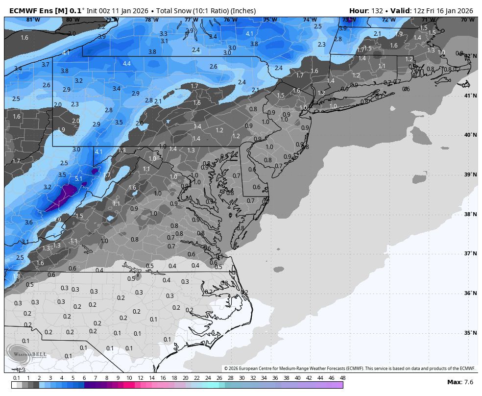
Shoot...since storm 1 seems to have limited moisture potential, if it can't get us at least a modest 3-6", I'd rather that fizzle to leave room for storm 2, tbh
-

January 2026 regional war/obs/disco thread
H2Otown_WX replied to Baroclinic Zone's topic in New England
Not that anyone cares but the models sucked with this storm. The Euro, HRRR, and NAM from last night had 0.50 to 0.85 for most of CT and instead it was only a couple tenths. GFS actually did the best as it was much drier. -
Nah pd2 combined with feb 2010. PD 1 was a sharper trough and less gulf inflow.
-
stop posting on this forum. hooray!
-
If that Jan 25 storm happened as depicted …I literally would I don’t know what id do
-
The EPS also improved vs 12z.
-
First 10 days. Must be some hits from threat 2 in here.
(3).thumb.png.d4dec375bb5a29db6fcd21b654eff550.png)
-
Its not so much that it loses it, it's that the low is further north than the GFS so the precip is too. It did move more to the south and west vs 12z with the slight step towards the GFS.
-
That storm is pd2 combining with pd1
-
I liked their look for the second system....the ridge out west becomes better oriented.
-

January 2026 Medium/Long Range Discussion
NorthArlington101 replied to snowfan's topic in Mid Atlantic
More realistic - EPS mean is better tonight. Goodnight!
-
Yeah stall the entire geopotential gradient just south of us with a 2000 mile long high to the north. Works for me.
-
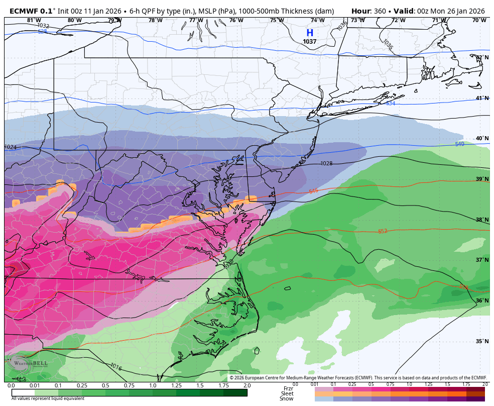
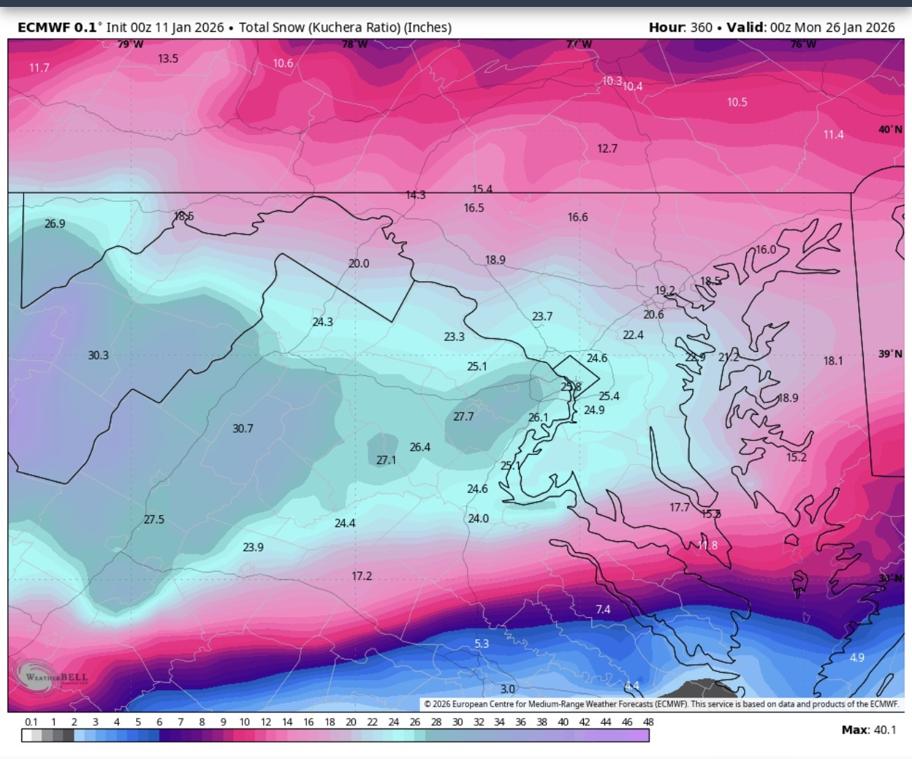
nice 0z suite. we figured out that there'll be moisture issues with january 15th, but at least the h5s were better. 0z euro was the man of the match tonight, stole the show. gave us the most improvement for the first system, and then ends off with by far the biggest snowstorm in recorded history, probably beating the washington-jefferson snowstorm that dropped 3ft unofficially. Of course that's not enough to satisfy Ji, but otherwise that would be amazing. Good night, see y'all at 6z!
-

Winter 2025-26 Medium/Long Range Discussion
KeenerWx replied to michsnowfreak's topic in Lakes/Ohio Valley
Pretty impressive LE signal on the globals for Wed/Thu, targeting a corridor from NW Indiana into NE Illinois. Probably won’t read deeper into it until Monday, but definitely tuned in. -
585-588 dm in the Pac NW and a ULL with 519 dm into the southeast that's nuts. If it digs more and gets a few more ticks west,look out.
-
Might be the craziest run we’ve ever seen in modeling history
-
That is a 3-4 feet storm


(3).png.0fcb4766a1a256dbe093c28c65010460.png)