All Activity
- Past hour
-
I do not think this is subtropical. It is fully attached to a front and I see no evidence of a warm core, just warm air on eastern side south of a warm front. Also if you watch water vapor loop it is within a broader upper level system centered over WNC. These nor Easter’s can be quite strong and prolonged, as evidenced by winds gusting above 50 on the OBX for the third straight day. The folks jumping on naming this haven’t seen a proper nor Easter in a while! These are fun systems to watch
-

2025 Atlantic Hurricane Season
WxWatcher007 replied to BarryStantonGBP's topic in Tropical Headquarters
It’s over increasingly marginal SSTs and doesn’t have a lot of time before it’s either onshore or tucked into the coast. If that boundary weren’t so clear I’d say it has a solid chance of subtropical development, but I just think this one isn’t going to get there. I don’t think the NHC would pull the trigger on that. Not this year at least with them missing/slow to designate two TCs this season. If this were off of Wilmington, I think it’d be a different story given SSTs. It’s firing good convection, but you really want to see it over the center. On radar though the presentation is actually pretty nice with some spiral banding evident. Worth a casual eye in case my analysis is wrong lol. -

September 2025 OBS-Discussion centered NYC subforum
bluewave replied to wdrag's topic in New York City Metro
You know it’s a dry pattern when the main interest is how close the .50 line gets to NYC.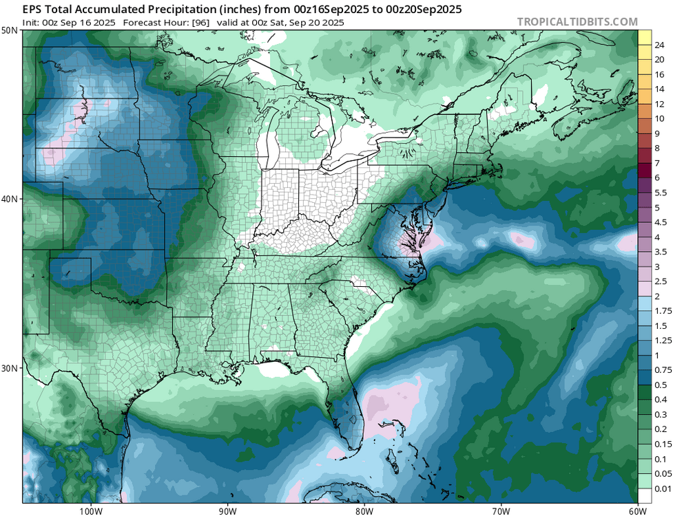
-
Another dry day over here in W. Central MD. Have noticed an early corn harvest this year. The field behind my house is done, has been for about a couple of weeks. On our walk this past weekend you could see where you would have no problem crossing parts of the Potomac on foot to certain islands. Very shallow in many places. I know weather gets into patterns seems we have been stuck in one for about 3 years now over here. Many days where I have watched hopeful rain coming in only to see it hit the dry dome. Have had a bit more storms break through this year than past. But looking at my weather station have not had any rain since 9 days ago. Rain for me gives a feeling of refresh. And I need a refresh. Going to make some apple crisp now.
-
While things are slow, I have a basic general question- Can someone explain to me why there is no discussion of the storm off Virginia as tropical or at least subtropical. The analysis, if I am reading it correctly, seems to have it as having a symmetric warm core. What is missing to at have this given a designation? https://moe.met.fsu.edu/cyclonephase/gfs/fcst/archive/25091606/11.html Edit: I see it being discussed on the main Tropical thread.
-
Do you think that this possibly could have properly been classified as a subtropical storm? Is this mainly a baroclinic low but with some tropical characteristics?
-

September 2025 OBS-Discussion centered NYC subforum
wdrag replied to wdrag's topic in New York City Metro
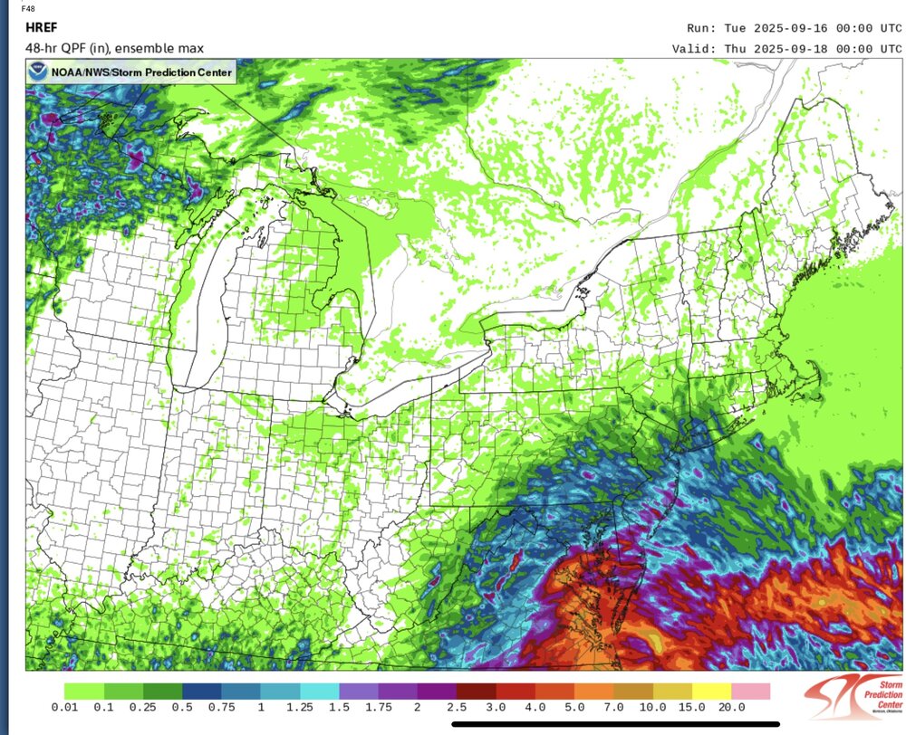
Good morning again... 1002A check of tropical tidbits for the 12z/16 NAM 12 and 3K vs reality and the 12z HRRR. 12z/16 NAM suite looks terrible to start... too far south by many many miles. Difficult to believe the initialization of qpf is so bad. EMC needs to check this. In the meantime the 12z HRRR looks like a much better start. Not saying anything about the outcome tomorrow, no different than above but for today... yikes. -
2. Eastern Tropical Atlantic: A tropical wave emerging off the west coast of Africa is producing an area of disorganized showers and thunderstorms. Some slow development of this system is possible towards the mid to latter part of this week as it moves westward at 15 to 20 mph, moving from the eastern to central portion of the tropical Atlantic. * Formation chance through 48 hours...low...near 0 percent. * Formation chance through 7 days...low...20 percent.
-
But what do you think about the possibility that this also has some tropical characteristics making it subtropical?
-
hope the euro is right for Thurs morning. going to need it
-
How did I know you would elicit a wrothless contribution from you.....let me ask you this...say you have a routine that consists of making disparaging remarks to winter enthusiasts on a weather forum while taking a $hit each day...I know, not like any loser would do that, but humor me. Each day, you notice prior to flushing that the log that represents the culimation of your efforts is brown; but this one day it's actually blue. While it's not remarkable that there is yet another log in the toilet after trolling 40/70 online, would it be notable that saig log was blue instead of brown? The dog sh cfs is consistently warm, bro. Ponder that while harassing AMWX members from the $hitter tomrrow-
-
2025 Atlantic Hurricane Season
WxWatcher007 replied to BarryStantonGBP's topic in Tropical Headquarters
It’s still clearly baroclinic—attached to a frontal boundary. You can see it clearly in the visible satellite. Same impacts as a TS, but just not tropical. -
Jennettes pier is gusting to 65, sustained at 42!!! (MPH)
-
Euro has rain at 300 hours so I guess we can look forward to that
-
Just give me until 12:00 pm in Poolesville.
-

September 2025 OBS-Discussion centered NYC subforum
donsutherland1 replied to wdrag's topic in New York City Metro
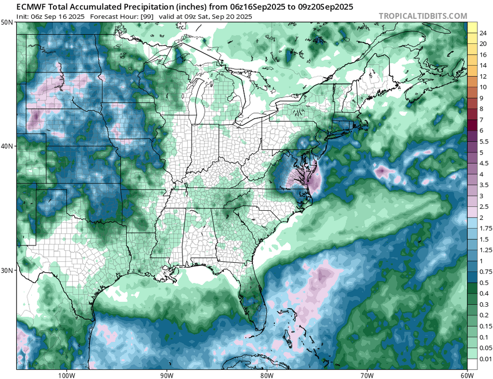
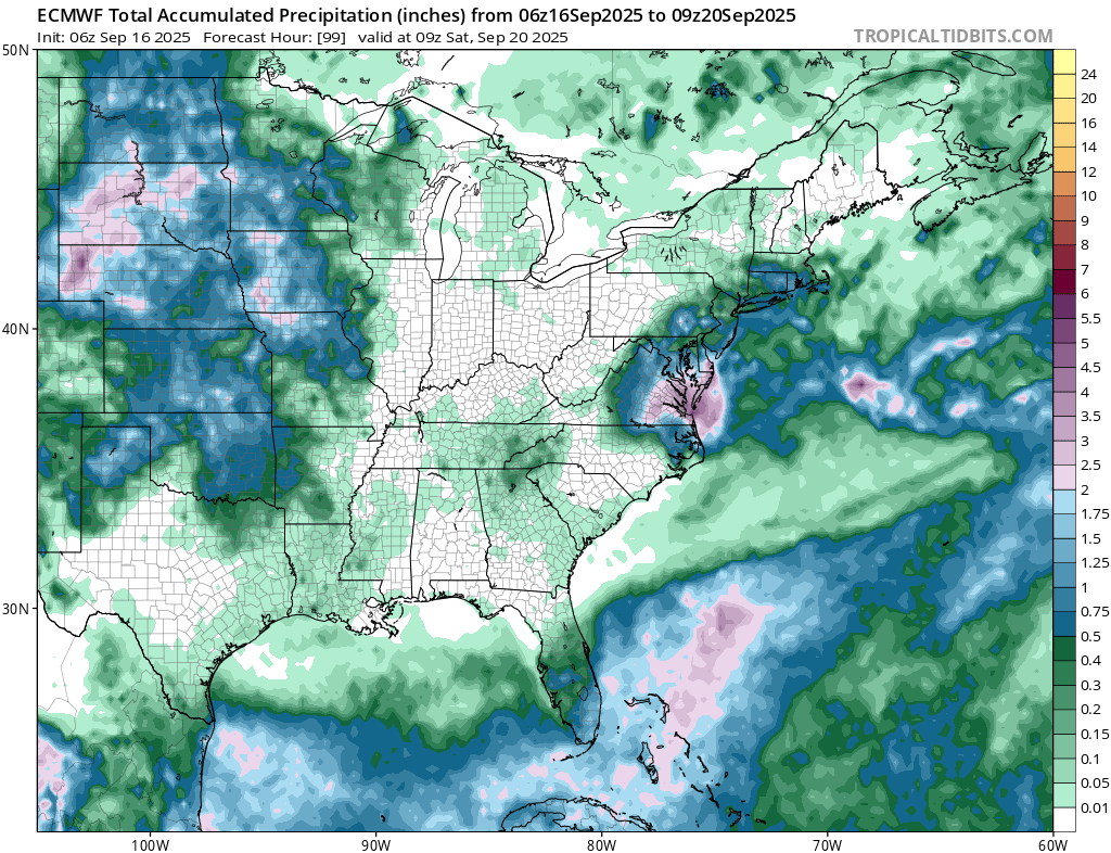
I believe Wdrag's analysis is on the mark with rainfall potential for parts of the area. The system responsible is an impressive and strengthening coastal low (non-tropical). The guidance can sometimes be too sharp with the cutoff of precipitation. It wouldn't surprise me to see Atlantic City wind up with 0.50"-1.00" to perhaps 1.50" of rain and NYC wind up with around 0.25". I do think we'll see amounts fall off sharply north and west of New York City. In terms of outcomes, Atlantic City and Georgetown have already received more rainfall than had been expected on the guidance for the 6-hour period that will end at 18z. -
True. In this case though, keep in mind that this wasn’t even given a 10% chance in any TWO to become just a subtropical depression. The TWOs cover both tropical and subtropical depression+ development potential.
-
Keep in mind that this wasn’t even given a 10% chance in any TWO to become just a subtropical depression. The TWOs cover both tropical and subtropical depression+ development potential.
-
There's a pill for that.
-

Central PA Summer 2025
Mount Joy Snowman replied to Voyager's topic in Upstate New York/Pennsylvania
Low of 57. Any rain we can squeeze out tonight or tomorrow would be much obliged. -
go on....
-
By rafting, do you mean walking 10 miles down a river towing a raft behind you?
-
Can you raft?
-
They are hyping for likes, follows, clout, retweets and views, as per usual. If just the NE PAC was warm and it was cold in the western North PAC around Japan (2013/2014) then yes that would be a +PDO alignment and would have that correlation. We don’t have that
-
I noticed that after the bridge, but went away towards HYA. I was told that is due to the cicadas. They peal away the bark of new growth to lay eggs or nest or whatever and that kills the new growth. So that's why you see the edges with the brown leaves.


.thumb.png.4150b06c63a21f61052e47a612bf1818.png)


