All Activity
- Past hour
-

E PA/NJ/DE Spring 2026 Obs/Discussion
The Iceman replied to PhiEaglesfan712's topic in Philadelphia Region
My buddy texted me that he was driving home from Hatfield Ice and that there’s tons of tree damage in the roadways across central and lower bucks. -
Ocean County bubble breaking away the squall line as usual
-
Well thats whats in the official, set in stone records so i have to use it if im going to highlight the airports on the map. A lot of them are wonky, not just BDL, and not just for the late 90s or 00s. People claim a lot of the NYC data is low, as recent as the blizzard of 2026, but it kinda is what it is. And BDR is notoriously low. yea i remember the blizz of 16 was very low for DCA.
-

E PA/NJ/DE Spring 2026 Obs/Discussion
LVblizzard replied to PhiEaglesfan712's topic in Philadelphia Region
Reports of a microburst or possible weak tornado in south Allentown. Trees and wires down everywhere just north of the Lehigh Street exit off I-78. -
E PA/NJ/DE Spring 2026 Obs/Discussion
The Iceman replied to PhiEaglesfan712's topic in Philadelphia Region
TTN gusted to 58, I was going to guess at least 60 mph winds here. -
Under the gun here...wild winds freight train and power flickered
-

2025-2026 Fall/Winter Mountain Thread
Buckethead replied to Buckethead's topic in Southeastern States
5.75" now with moderate snow still falling. It's beginning to get blown around quite a bit. Sent from my Pixel 10 Pro using Tapatalk -
E PA/NJ/DE Spring 2026 Obs/Discussion
The Iceman replied to PhiEaglesfan712's topic in Philadelphia Region
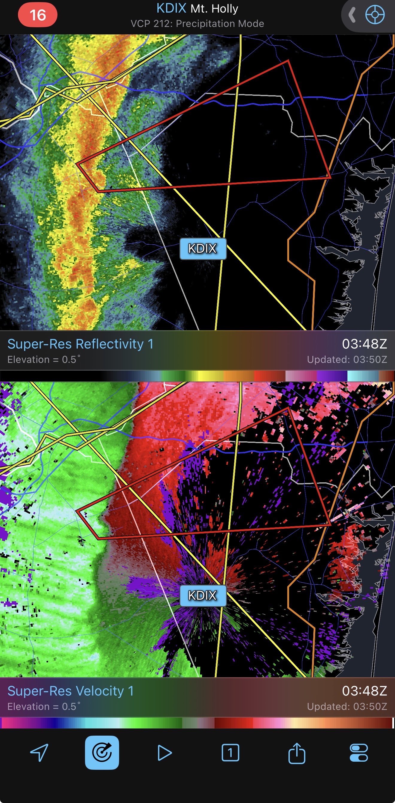
Tornado warning! Couplet went right over McGuire Air Force base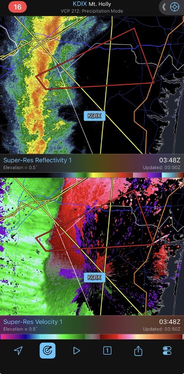
-
This is one hell of a squall line. Roaring winds with heavy rain; sounds like freight train outside.
-
E PA/NJ/DE Spring 2026 Obs/Discussion
The Iceman replied to PhiEaglesfan712's topic in Philadelphia Region
Temp already down to 49F , we were at 61 before the squall. -

E PA/NJ/DE Spring 2026 Obs/Discussion
nesussxwx1 replied to PhiEaglesfan712's topic in Philadelphia Region
Down to ~45F. About a ~17 degree drop in 45 minutes. -

Pittsburgh/Western PA WINTER ‘25/‘26
PghPirates27 replied to Burghblizz's topic in Upstate New York/Pennsylvania
Let’s go about 5” here!!!! -

2026-2027 El Nino
Stormchaserchuck1 replied to Stormchaserchuck1's topic in Weather Forecasting and Discussion
Since the pre-El Nino composite has worked out 4 months in a row, here is April's preceding El Nino's that develop later in the year.. let's see if we can make it 5 matching months in a row -

E PA/NJ/DE Spring 2026 Obs/Discussion
MGorse replied to PhiEaglesfan712's topic in Philadelphia Region
Yup, I had the backdoor open before the squall arrived and could hear the roar of the wind approaching. Classic low-topped squall line. -
 Oh no such a shame to hear may he rest in peace.
 -
 2023-2024 would like a word with you.
 -
E PA/NJ/DE Spring 2026 Obs/Discussion
The Iceman replied to PhiEaglesfan712's topic in Philadelphia Region
That squall line really delivered wow. Crazy winds associated with it, can’t ever remember seeing flashes in the distance from transformers blowing. You could hear the roar of the wind too before it was on top of us. Reminded me of the derecho a few years ago just without the lightning. Can’t believe we still have power -
E PA/NJ/DE Spring 2026 Obs/Discussion
MGorse replied to PhiEaglesfan712's topic in Philadelphia Region
Power flickered and saw several power flashes in the distance. Peak gust to 56 mph. -

Central PA Spring 2026 Discussion/Obs Thread
CarlislePaWx replied to Voyager's topic in Upstate New York/Pennsylvania
Well, it's looking like the party's over here. The snow has quickly come to an end. Radar clearly shows a very sharp back end that has been rapidly progressing east, and has just reach me in central Cumberland County. The temp is holding now at 32.4 degrees. Using my car for accumulation measurements, I just measured 0.3" of snow. Sidewalks and streets are still just wet. Grass is white everywhere. Maybe during the overnight snow showers develop with enough intensity to add a bit more on to the storm totals. -

Central PA Spring 2026 Discussion/Obs Thread
Mount Joy Snowman replied to Voyager's topic in Upstate New York/Pennsylvania
Temp down to 33 with borderline heavy snow but the fun appears to be over soon. Still cool to see. -
I have sleet
-

E PA/NJ/DE Spring 2026 Obs/Discussion
CoolHandMike replied to PhiEaglesfan712's topic in Philadelphia Region
I think there's room for improvement there, then. Decades ago when I worked on a naval air station, a severe thunderstorm warning was treated very differently from an extreme wind event. While the two may share some similarities, they were not equal in terms of protocol. These days I'm just some Joe Schmoe behind a keyboard with a worried wife from SoCal and a mom who wants to know if she needs to put the horses in because of lightning. When something doesn't make sense to me, I complain about it on the internet. We do this for fun and I don't envy the job our mets actually have to perform. I guess I'll just take everything I learned here tonight and apply that going forward. Thanks for your service and your replies. Down to 37°F and I'm hearing pingers on the windows. An interesting day and night all around, regardless. -
E PA/NJ/DE Spring 2026 Obs/Discussion
nesussxwx1 replied to PhiEaglesfan712's topic in Philadelphia Region
Power flickering. Seeing temperatures down 20-25 degrees in some parts of SEPA. Impressive front. -

Central PA Spring 2026 Discussion/Obs Thread
MAG5035 replied to Voyager's topic in Upstate New York/Pennsylvania
Synoptic stuff is done here. Most things blacktop stayed wet for the most part, but about 2.5” on pretty much everything else. Add some thunder snow and some gusty winds to that and guess I can’t complain about an event like that. -

E PA/NJ/DE Spring 2026 Obs/Discussion
Birds~69 replied to PhiEaglesfan712's topic in Philadelphia Region
Snowing at State college, 27F, WWA, 2-4". We'll see some flakes...
.thumb.jpeg.f5c6ba9d911ec96b3b124f8606aee58e.jpeg)