All Activity
- Past hour
-
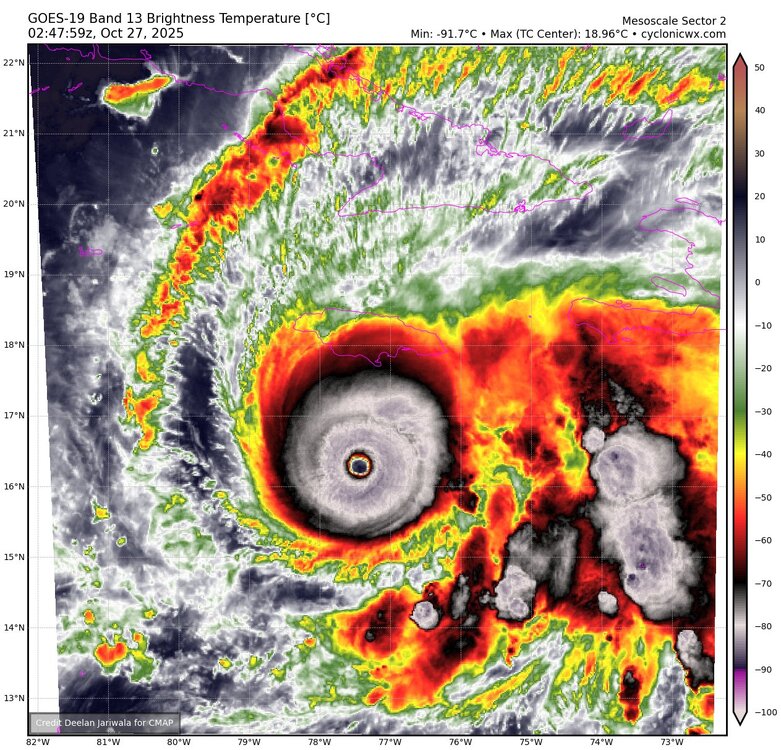
Probably perfect timing. This is peaking in satellite appearance. We’ll see if observational data concurs. Unless there’s a slow ERC or this ticks further west or east than expected, I am finding it increasingly hard to believe there won’t be a category five strike.
-
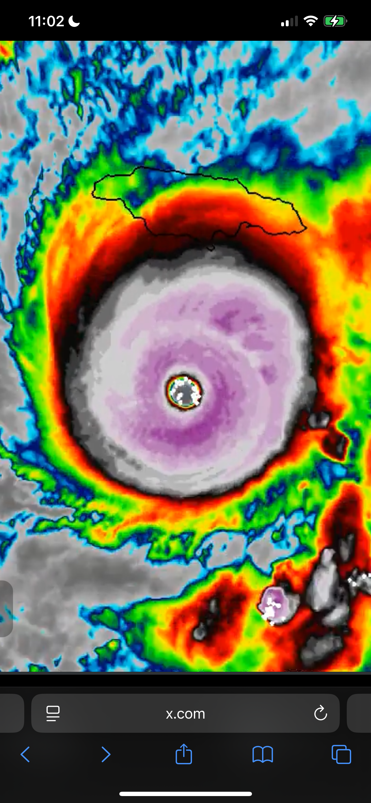
At first glance at sat imagery (if I knew nothing else) I'd have guessed it's a cat 5. Perfect symmetric buzzsaw that is the CDO.
-
Huge burst around the center just now. Yikes.
-
Yeah I read the discussion from the NHC and there was absolutely no mention of shear or undercutting or even fluctuations. They seem to think she is about to bomb to a Cat 5 and they are forecasting landfall at that intensity.
-
The next recon plane just took off from Curacao and will be in the eye in a couple hours.
-
I was just going to post. Just a big burst around the eye and core in the last few minutes. There is another flight that just took off. It’s heading in at the right time..
-
big 'un
-
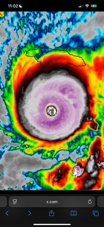
This is very sad and terrifying to see knowing that Jamaica is in the crosshairs of this monster. Hopefully something unexpected will change things at least a little bit for the better before landfall. Any weakening would be quite welcome obviously.
-

Spooky Season (October Disco Thread)
Torch Tiger replied to Prismshine Productions's topic in New England
Things are looking good for the things aren’t looking good for Jamaica camp -
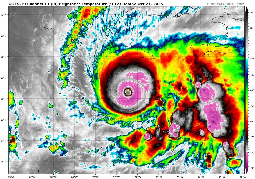
Insane last half hour or so on IR. Complete ring of -80s wrapping around now https://x.com/wX_nvck/status/1982645615374082373?t=IhnzuFVyTW0CM-DjZO-Ndg&s=09
-
Melissa is full nuclear now. All previous signs of an ERC rapidly disappeared after recon hunters flew out. It’s like a switch went off. Absolute nuclear….cloud tops rapidly cooled to -93 degree Celsius. That is extremely unprecedented in the Atlantic Basin. Infrared imagery is jaw dropping right now. Everything I’m seeing on satellite and infrared imagery points to a high-end cane making a run at sub 910mb pressures. Lightning is impressive and very rapidly spiked in the NE/E quad of the eyewall. Really wish we had recon flights enroute.
-
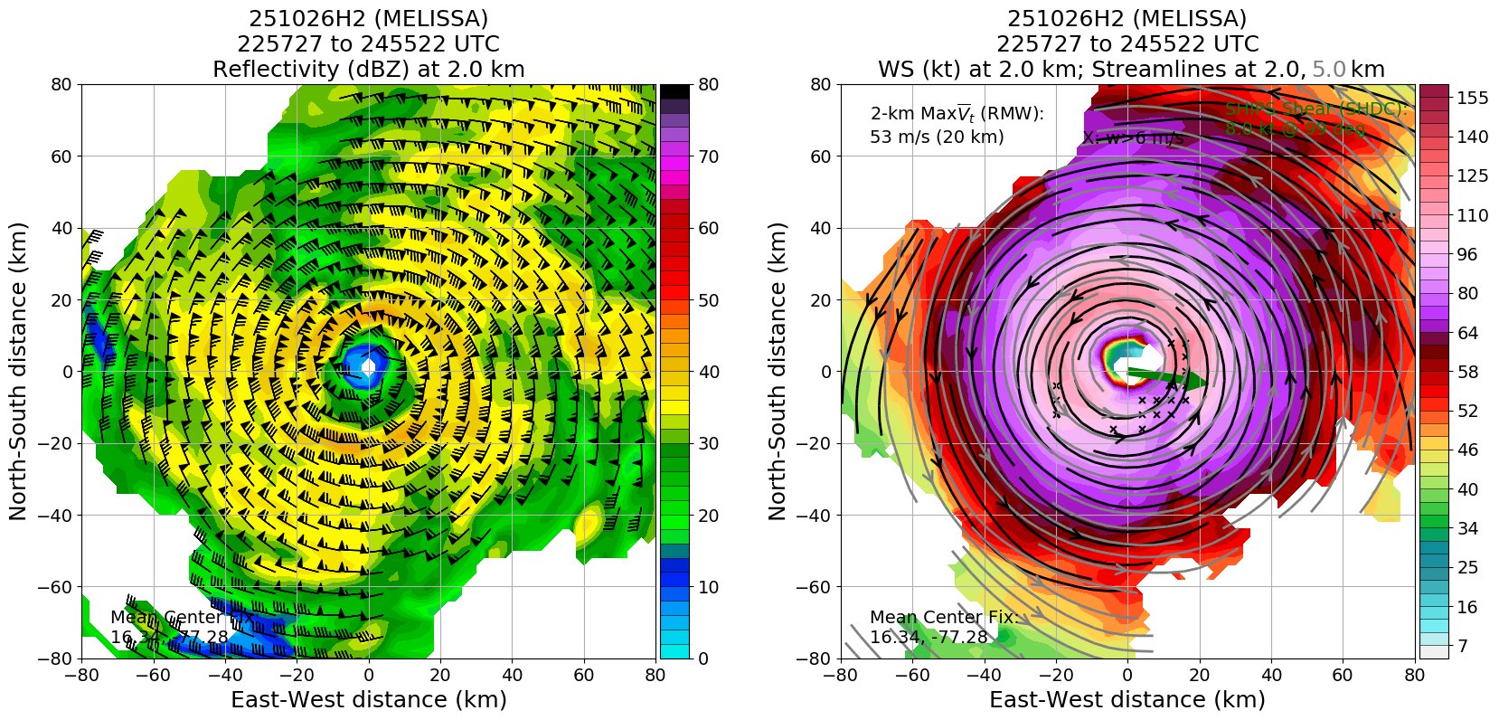
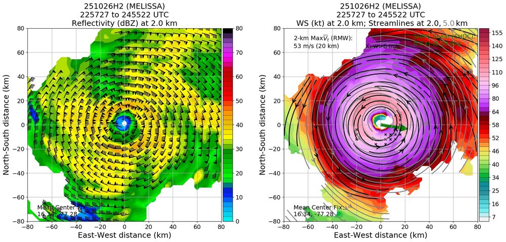
11:00 PM EDT Sun Oct 26 Location: 16.3°N 77.5°W Moving: W at 5 mph Min pressure: 933 mb Max sustained: 145 mph
-
This webcam over the hill in Island Park is pretty fun to watch. In the winter they set up a 7 foot tall ruler so you can see the snowdepth at any time. IP's longterm average is about 210" but lately (since 2000) they seem to be averaging more like 240". https://highmountainadventures.com/live-cam
-

-
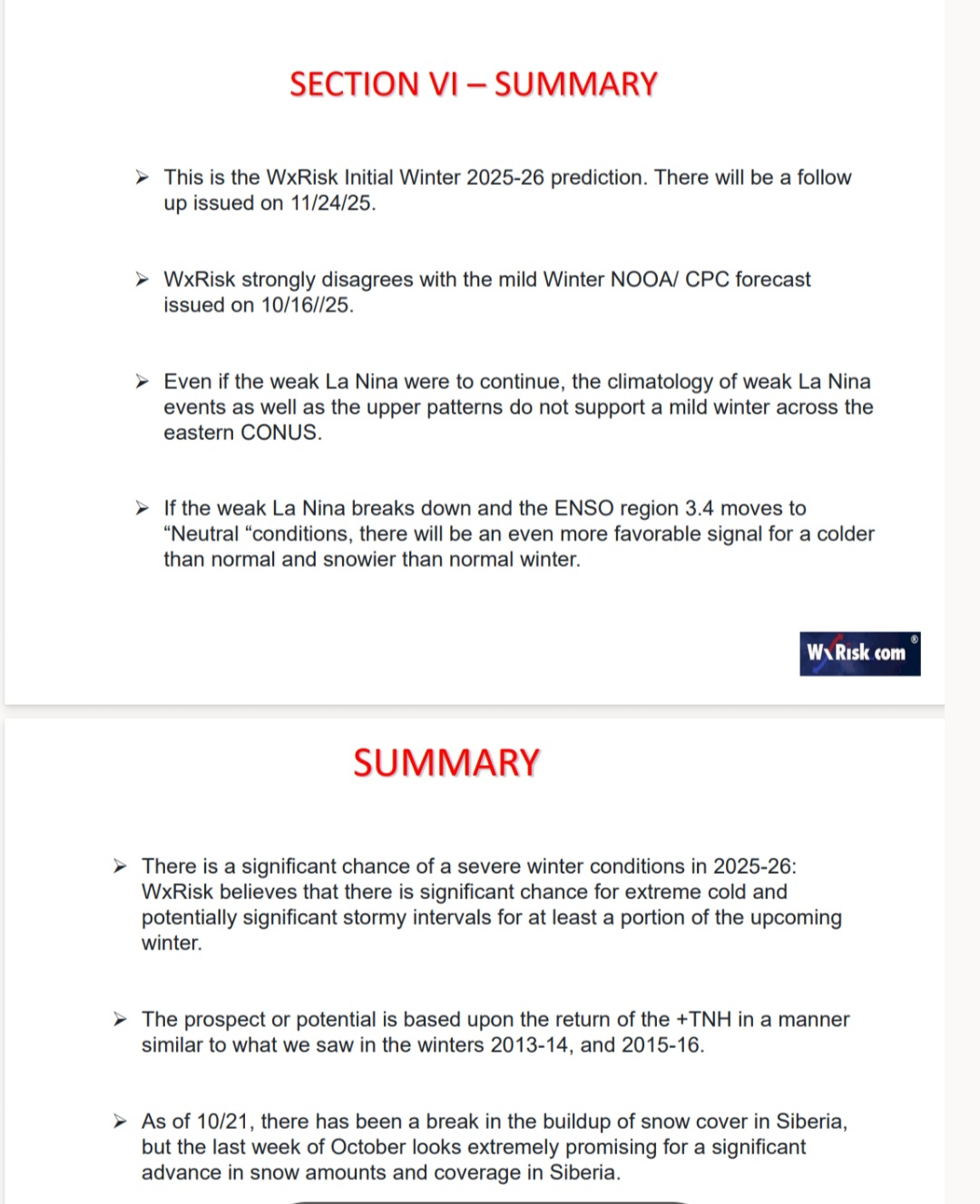
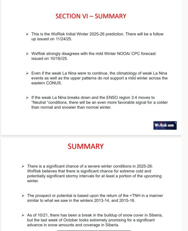
DT Preliminary Winter Outlook

-
DT Preliminary Winter Outlook
- Today
-
38 in Muttontown & 40 in Syosset.
-

Spooky Season (October Disco Thread)
mreaves replied to Prismshine Productions's topic in New England
I was cold playing golf at 1100’. We could see what looked like snow showers in the higher elevations of the Worcester Range. -
They look goofy lol
-
What a monster. Looks like it might do an ERC in the next 12 hrs or so. Not good, because then the wind field will expand further.
-

The return of the elusive Nor'easter. Drought buster or bust?
AlexD1990 replied to dailylurker's topic in Mid Atlantic
Cutting it a bit close for my liking, but I'll take some mixing paste if it means the whole sub gets plastered. Just give me some CCB on the backside as the low moves away after stalling for 3 days Sent from my Pixel 9 Pro XL using Tapatalk -
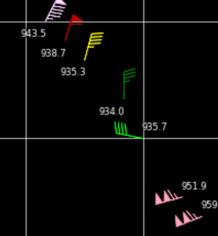
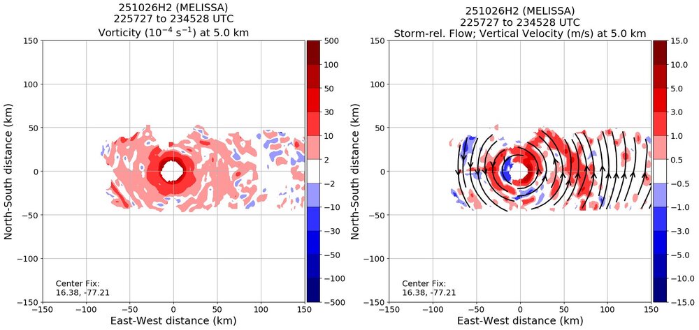
Pressure holding steady and no longer tanking. Looking at TDR, perhaps an outer eyewall trying to go up. Looks like an ERC or MERC about to commence soon.

-
Apparently hurricane hunters are struggling to hit the eye because it's small and turbulence. Hopefully they get a good sample before having to head back.
-
Yep. Was 39 now up to 39.8 with a breeze developing. Don’t see us going lower than 37
-
It looks as good as it ever has. Very cold cloud tops now rotating around core. I would be shocked if we didn't have a Cat 5 by morning.


.thumb.jpg.ad3a2e31d30aff035044689b311a0540.jpg)