All Activity
- Past hour
-
Power is out for a second time today. Damage x 2!
-
 Got a late start as I only had .08 at midnight but now have 1.62 in the bucket here in Poughkeepsie area. Right now temp 49, breezy, and rain.
 -
(002).thumb.png.6e3d9d46bca5fe41aab7a74871dd8af8.png)
Central PA Fall Discussions and Obs
ChescoWx replied to ChescoWx's topic in Upstate New York/Pennsylvania
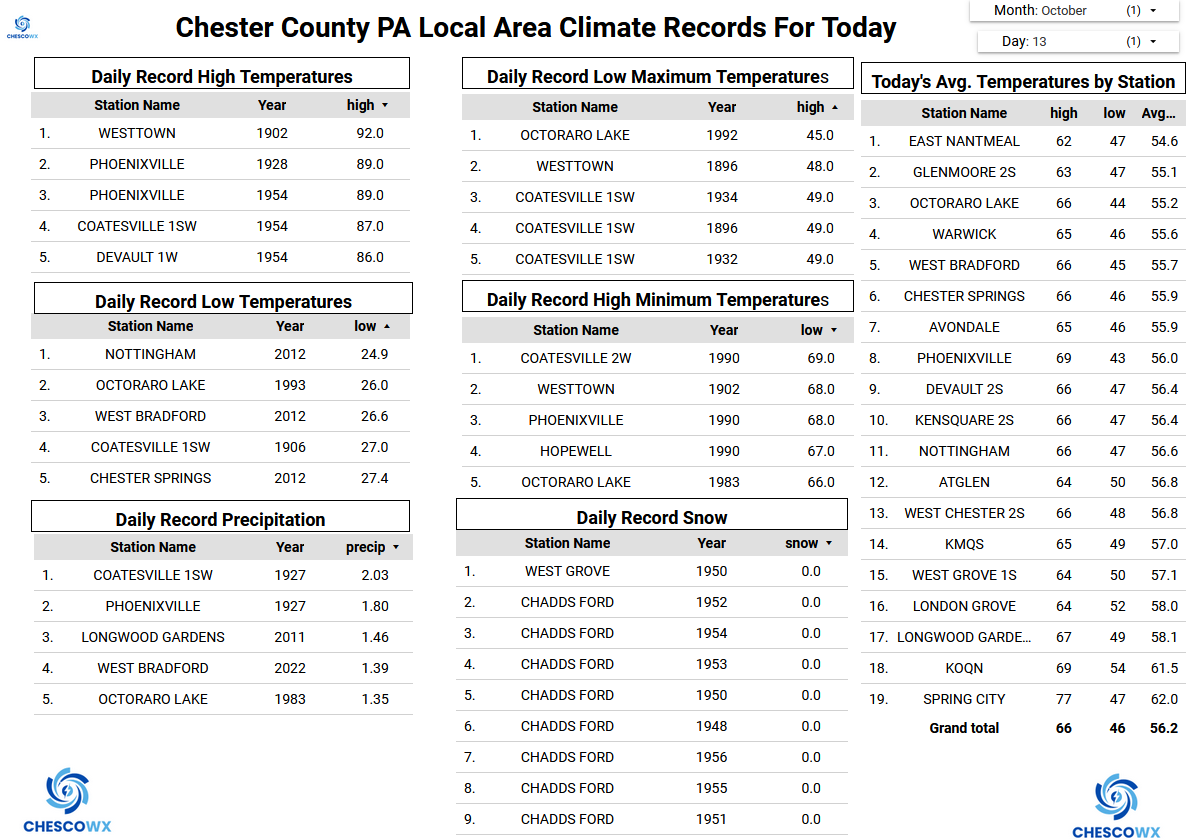
Here in East Nantmeal we have picked up 0.13" of rain so far today. This brings our 3-day total to 0.32" with steady but light rain still falling. Some models have up to another 0.25" to 0.50" of additional rain before the chances of showers start to diminish tomorrow. Temperature wise we should be well below normal levels for mid-October with highs in most spots in the low to mid 50's, Tomorrow we should see the warmest day of the work week with temperatures into the mid to upper 60's. We then see another cool down through the rest of the week. By Friday morning we look to see low temperatures in the 30's but many of our valley locations already saw their first freeze last week. The higher spots look to continue their growing (freeze free) season into November which has been typically the case for elevations above 600 feet across Berks and Chester Counties .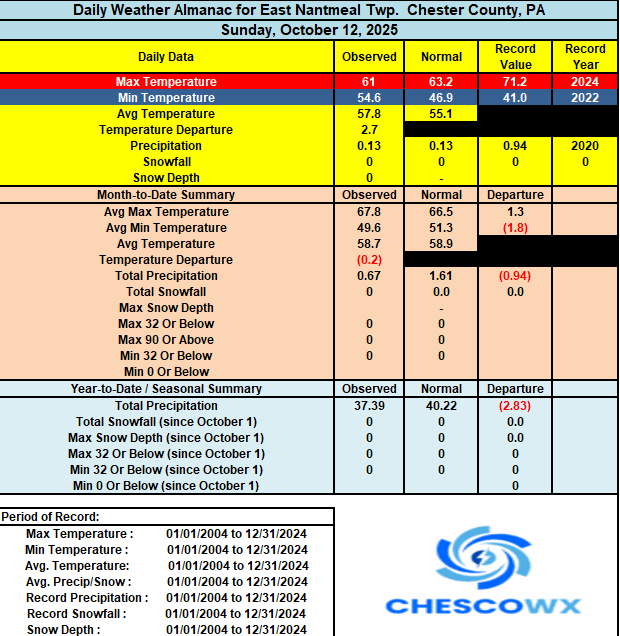

-
E PA/NJ/DE Autumn 2025 Obs/Discussion
ChescoWx replied to PhiEaglesfan712's topic in Philadelphia Region
Here in East Nantmeal we have picked up 0.13" of rain so far today. This brings our 3-day total to 0.32" with steady but light rain still falling. Some models have up to another 0.25" to 0.50" of additional rain before the chances of showers start to diminish tomorrow. Temperature wise we should be well below normal levels for mid-October with highs in most spots in the low to mid 50's, Tomorrow we should see the warmest day of the work week with temperatures into the mid to upper 60's. We then see another cool down through the rest of the week. By Friday morning we look to see low temperatures in the 30's but many of our valley locations already saw their first freeze last week. The higher spots look to continue their growing (freeze free) season into November which has been typically the case for elevations above 600 feet across Berks and Chester Counties .
-
 Interesting satellite loop this morning. Don't see dual lows like that often. http://www.meteo.psu.edu/ewall/PSUGOES_OV/loop30v.html
 -
 0.41" in Somerset (0.53" including Saturday's rain). The cutoff is quite extreme, but this aspect of the event was (eventually) modeled well. Was hoping it might just push a tad further west. Better than nothing though! The drought continues.
- 589 replies
-
- 1
-

-
- heavy rain
- damaging wind
- (and 2 more)
-

Spooky Season (October Disco Thread)
tunafish replied to Prismshine Productions's topic in New England
Coastal York and Cumberland counties here in Southern ME have the lowest precip totals since 8/1, ranging from 2.13" to 3.15" - now the least in NE based on CoCoRAHS obs. Maybe we turn it around in winter. Looks like I'll be installing my own NWS precip can this year as the shutdown continues. My stake could use a resetting, too, but I am less confident in tackling that solo (and I don't think GYX wants me to, either). And now what's this I hear about a colonoscopy? I shoulda stayed in bed... -
 Only 0.42" here so far. Maybe we get a quarter inch more this afternoon into tonight? At least it's enough to give the vegetable garden a watering, but not nearly enough to bust the drought. I was hoping we'd get a lot more from this storm, but of course the signs were there that the heavier amounts would be to the south and east.
 -
 Over 230 active individual outages for pseg li with over 3k outages. The large amount of individual outages is what makes it so much longer to restore.
 -
I am El Nino! possibly 7-10" in South Carolina
-
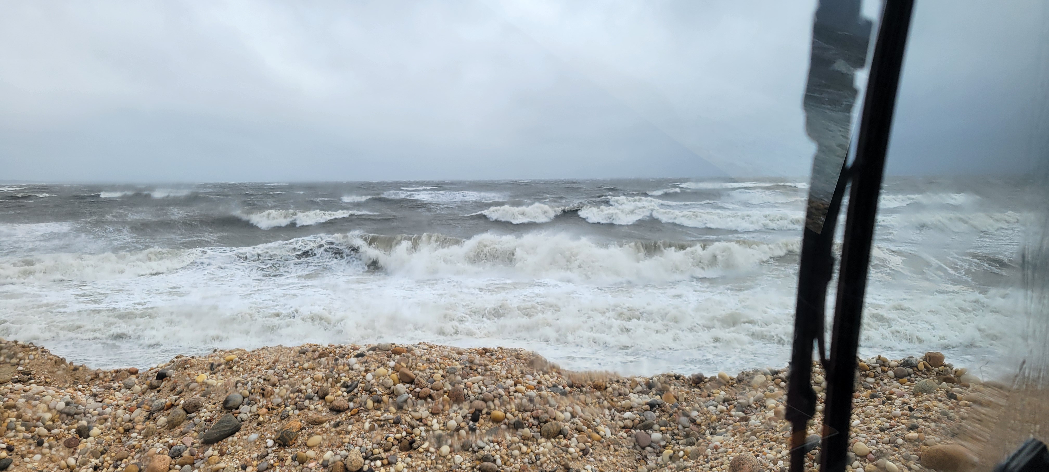
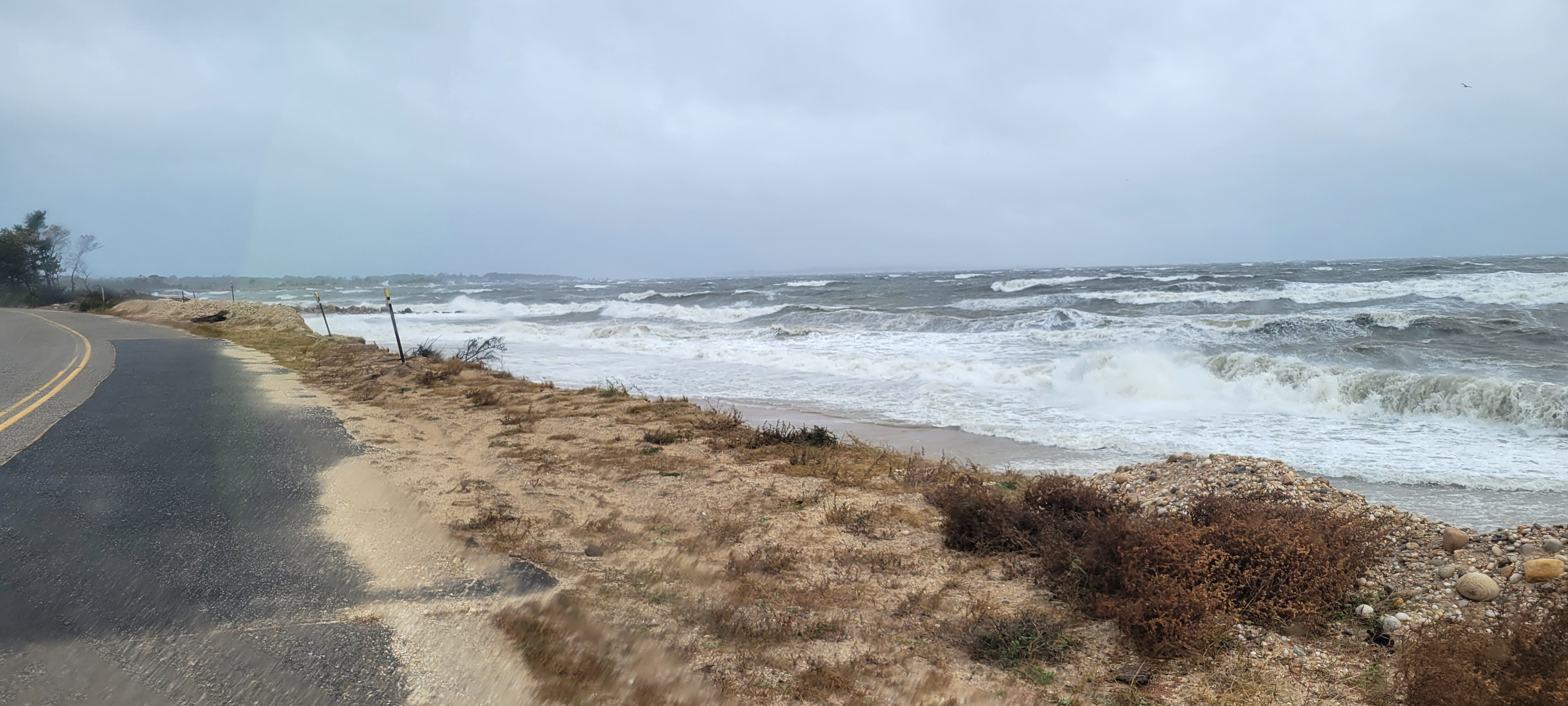
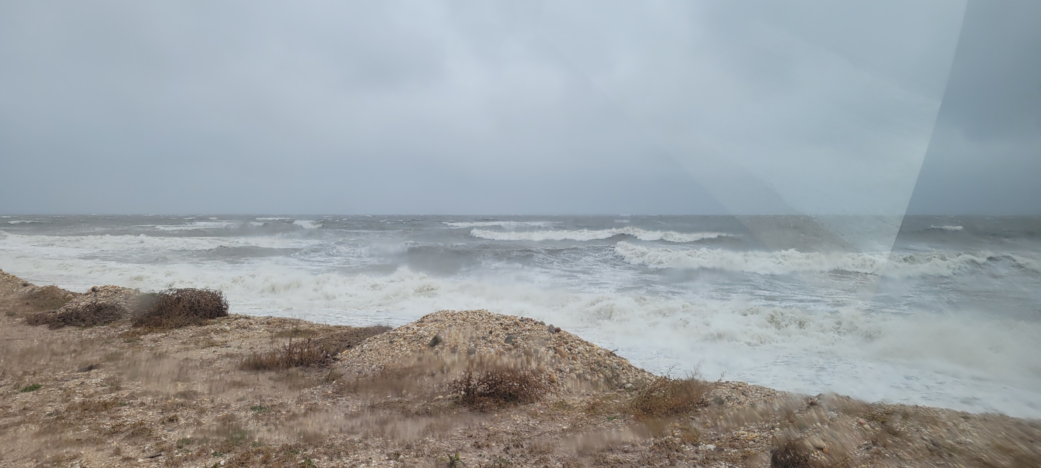
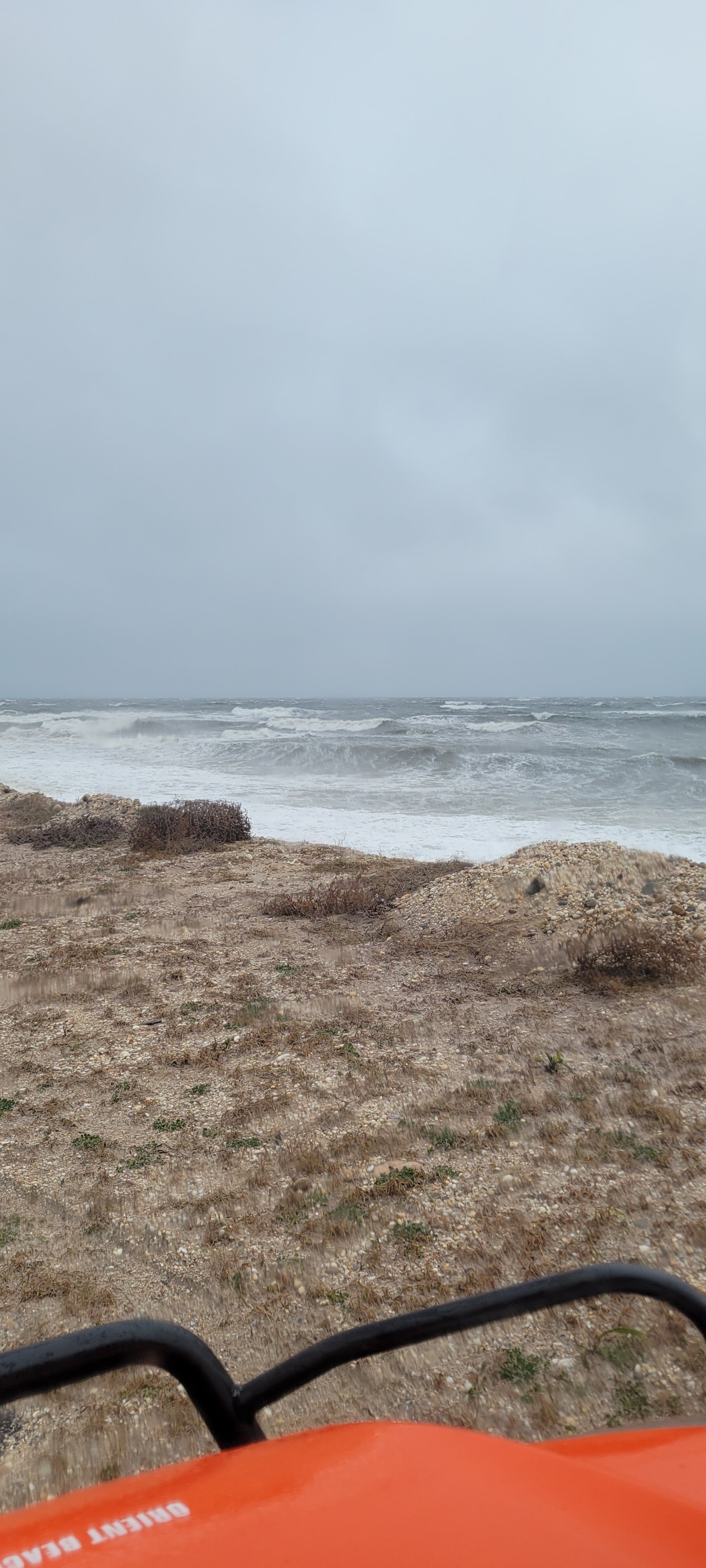
The winds are insane now in the 40s gusting to 50s should of kept the wind advisory imo. Tides are very high and low tide just happened few at 10 am.
- 589 replies
-
- 1
-
-
- heavy rain
- damaging wind
- (and 2 more)
-

2025-2026 ENSO
PhiEaglesfan712 replied to 40/70 Benchmark's topic in Weather Forecasting and Discussion
But those storms prove that last winter wasn't a no-chance winter. We've had many of those in the last 15 years (like 11-12 or 22-23). Last winter was more like 20-21. The difference is the storm tracks aligned perfectly for NYC in 20-21, not so much last winter. But the tracks were still there. Also, 20-21 proved that NYC can still have good winters post 18-19. Or was that luck, and is NYC doomed to never have a great winter 20-21? -
If the projected AK/GOA trough pattern continues into early November and continues to cool and erode the “warm blob” then we will have a real big SST analog divergence with 2013. Early November 2013 is when the warm blob came back with a vengeance and the PDO flipped into a Victoria mode and stayed locked in through the end of that winter
-

Spooky Season (October Disco Thread)
Typhoon Tip replied to Prismshine Productions's topic in New England
At least we got a decent Saturday ( recently ...), because this, this day is why I don't believe New England is worth it in the long run. I just find this to be more loathsome than any so-called top 10 day is lovely. There can never be equality in a weather solvency becuase bad vs good? the bad is always that much worse. Anyway ... I'd lost track of how many proverbial top 10 days we'd had since mid summer. Eventually ... some sort of justice ( seeing as New England is clearly persecuted for ever experiencing weather joy ) was going to come calling. This, here on this day and as evidenced in this satellite shit show below, is the ass of the judge hangin' over us ... midway through a colonoscopy prep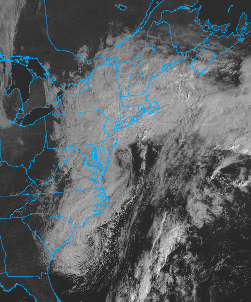
-
 Yea that was a meaty band. Squall just blew through and brought me up to 2.44”. Lots of wind in these bands
 -
MJO is forecast to make a serious pass in 5/6 by the GFS.
-
Still dry (as forecast, maybe a bit tonight). Just enough wind to wiggle the few remaining intact leaves.
-

2025 Atlantic Hurricane Season
NorthHillsWx replied to BarryStantonGBP's topic in Tropical Headquarters
IMO it could’ve been named well before they named it. That it existed within an upper level low was why it was just what it was: a subtropical storm. Honestly a very impressive one at that to have the symmetry and sustained convection at that latitude. Would’ve loved radar from that storm because it would’ve looked like a hurricane haha. As for JB naming coastal storms, absolutely not. TWC already subjected us to that with winter storms and it’s a joke. Nor Easter’s are part of life on the east coast and honestly until this year we’d been in a very long dry spell for significant ones. We can’t name every weather system just bc it’s impactful. You’d have to start naming lows that hit the west coast too if you went that route. It’s just not a good idea. Coastal lows are very impactful but they are nothing like a hurricane and coastal towns know how to prepare accordingly as is. This one has literally 0 tropical characteristics and comparing it to Karen is like comparing an apple to an orange. Their both low pressure systems is about the only similarity. He has gone off the rails, and it’s sad because he had been one of the better Mets back in the day but it’s been so long I just cancel anything he says out as noise at this point. As for this system, lots of coastal flooding from New England to the Carolina’s and some areas of significant flash flooding in SC but overall a lot of areas saw beneficial rain. For a complicated forecast the storm ended up doing about exactly what was expected for the entire coast. -

Central PA Fall Discussions and Obs
Superstorm replied to ChescoWx's topic in Upstate New York/Pennsylvania
56F 0.31" rain total so far. -
 2.20 here so far, that heavy batch that passed over Queens/Nassau overnight helped me catch up to you guys
 -
Picked up an additional 0.02” overnight at some point. Currently thick overcast and 60.4 still breezy but nowhere near the constant gusts of yesterday. Saw a lot of inland areas recorded gusts over 40 yesterday which is very impressive for a nor Easter