All Activity
- Past hour
-

12/14: Sunday funday? Will the south win again?
dailylurker replied to TSSN+'s topic in Mid Atlantic
According to the gfs non of us need to worry about snow after this week. I wonder if we can beat the heatwave on Christmas back in 2017 when it was 77 on Christmas eve? -

-
I see we have already erased 2020 from your memory.
-

December 2025 regional war/obs/disco thread
Damage In Tolland replied to Torch Tiger's topic in New England
Ukie is about how I envision things playing out -

December 2025 regional war/obs/disco thread
DavisStraight replied to Torch Tiger's topic in New England
You called it earlier, looks like you're gonna be right. Let's hope for good things after new year. -
He wouldn't be able to get it all if that verified lol
-

12/12: The little Friday clipper that could? Or won't.
WesternFringe replied to dailylurker's topic in Mid Atlantic
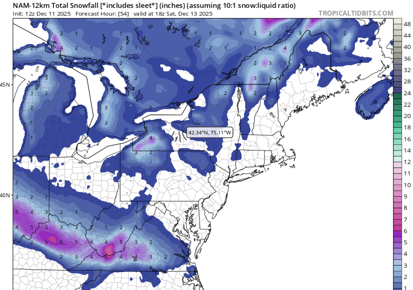
Here is the 12z Nam 12k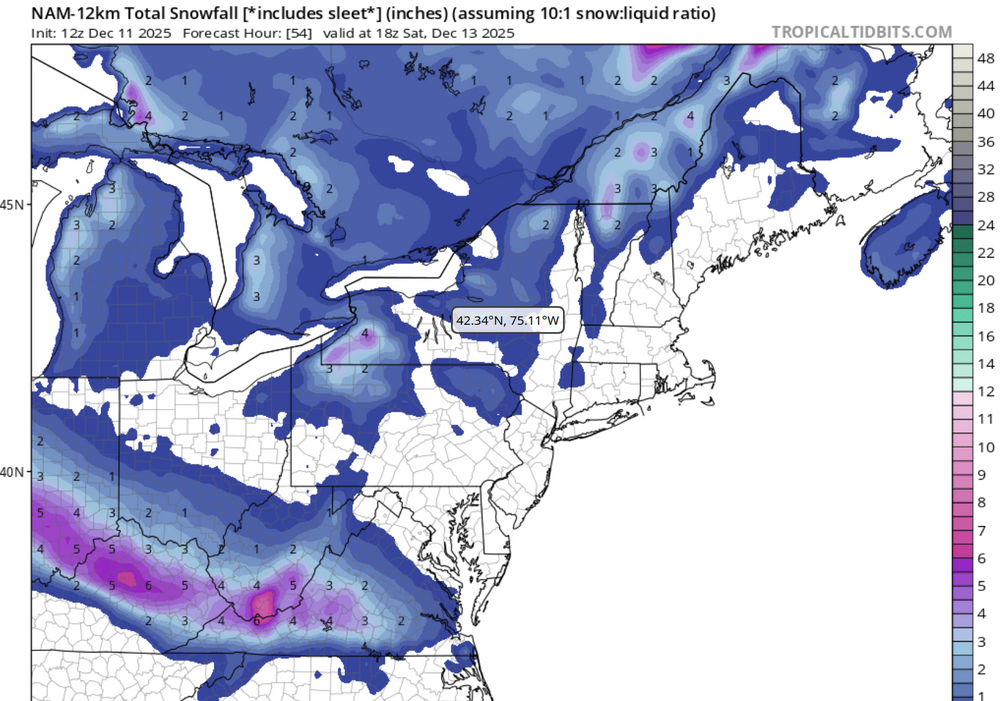
-
I'm really interested in what evidence the people "weenieing" this statement of fact have in rebuttal. Because over my lifetime, this has clearly been the case. Here is the last 35 years of data from a diverse assortment of locations. Snowfall has plummeted, especially in lake effect and upslope areas, where a simple linear trend implies snowfall has been cut in half since 1990 (see, e.g., Cleveland and Elkins, W. Va.). I'm sure they'll complain about the start date - but the 1990s were considered mild at the time, with people pining for the snowier/colder 60s and 70s and comparing it to the so-called "cyclical warming" of the 1930s and 40s. This period also covers the bulk of my lifetime and with consistent procedures for snow measurements. Cleveland, Ohio Charleston, W. Va. Elkins, W. Va. Syracuse, NY Boston, MA Rochester, NY
-

Minor snow possible sunday 12/14/25
allgame830 replied to WeatherGeek2025's topic in New York City Metro
honestly don't take this the wrong way but why do you have to nitpick everything everyone says.....someone said 3-5 but looking 10:1 it was like 2-4... come on dude give it rest. its a wonder why your a limited poster!!!!!!!!! -
Thats a great hypothesis and concur. My place is about 10-12 miles ENE of WxWatcher007 in SLK- on the base of the Northern slope of Whiteface Mountain. Its around 1900 ft. I see the same phenomenon (and did this morning, too) regularly of slight enehanced upslope rates/accumulation overnight. Thanks for characterizing what I've noticed but hadn't articulated! Interesting.
-
More for the Grinch to steal.
-

Central PA Winter 25/26 Discussion and Obs
Itstrainingtime replied to MAG5035's topic in Upstate New York/Pennsylvania
What's the current snowpack where you go? -

Minor snow possible sunday 12/14/25
eduggs replied to WeatherGeek2025's topic in New York City Metro
Good trends at 12z so far. UK kind of splits the difference between the RGEM and NAM. -
Central PA Winter 25/26 Discussion and Obs
Itstrainingtime replied to MAG5035's topic in Upstate New York/Pennsylvania
Ukie looks solid for those who've been on outside looking in so far this season. -

Central PA Winter 25/26 Discussion and Obs
pasnownut replied to MAG5035's topic in Upstate New York/Pennsylvania
obligatory cam post just for you pal... http://www.swedenhillsnocam.com/ Coudersport getting raked right now. Northerwoods are and have been a winter wonderland since before Turkey day. -
That's quite the snowstorm on the 22nd on the 12z GFS in CNE/NNE.
-

Minor snow possible sunday 12/14/25
snowman19 replied to WeatherGeek2025's topic in New York City Metro
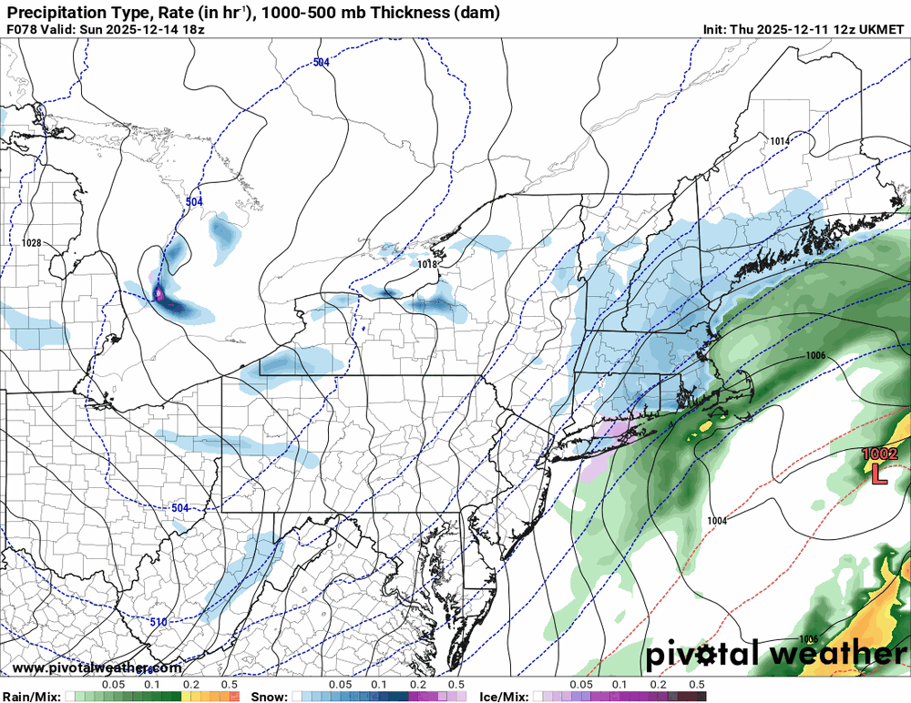
I will say this….for a storm less than 2.5 days away, there is ridiculous disagreement with the models. You have the NAM/UKMET in one corner showing a full blown snowstorm. The RGEM I guess in the “middle”, the CMC hasn’t run yet for some reason, but assuming it will look like the RGEM. And you have the GFS/RRFS/GFS-AI/ICON with a minor event. Let’s see what the EURO/EURO-AI does….. -

December 2025 regional war/obs/disco thread
powderfreak replied to Torch Tiger's topic in New England
Some might call it a candidate? -

Central PA Winter 25/26 Discussion and Obs
AccuChris replied to MAG5035's topic in Upstate New York/Pennsylvania
12z GFS says nahhh . -

Minor snow possible sunday 12/14/25
WeatherGeek2025 replied to WeatherGeek2025's topic in New York City Metro
anybody saw the CMC? -
Colin ?
-

12/14: Sunday funday? Will the south win again?
RevWarReenactor replied to TSSN+'s topic in Mid Atlantic
This honestly looks right. Tracks the climo over the last 10 years of the Dc to philly snowhole. -
Central PA Winter 25/26 Discussion and Obs
pasnownut replied to MAG5035's topic in Upstate New York/Pennsylvania
If cherrypickin season is now starting....RGEM is an LSV special, and one to add to the nice list. -
Ukie was some rain on the cape.............lol
-

2025-2026 ENSO
PhiEaglesfan712 replied to 40/70 Benchmark's topic in Weather Forecasting and Discussion
Sorry guys, but the MJO isn't going back to phase 8. Get ready to learn phase 5.