All Activity
- Past hour
-
It’s pouring in NYC
-
Thought the same thing.
-
Just like we discussed the other day
-
Correct!
-
This sounds fun. * At 849 AM EDT, thunderstorms had produced heavy rain causing flash flooding to occur across the Central and Northern portions of Chenango County. Between 3 and 5 inches of rain have fallen. Major flash flooding is already occurring and being reported across Chenango County. Numerous roads and bridges are flooded, as well as numerous homes taking on water, especially around Norwich, Sherburne, and New Berlin. At least 10 people are stranded due to flood waters. Chenango County is in a State of Emergency due to the flooding. No unnecessary travel in Chenango County is allowed.
-
That MCS is trending a bit more South recently. Interesting to watch for sure.
-

E PA/NJ/DE Summer 2025 Obs/Discussion
JTA66 replied to Hurricane Agnes's topic in Philadelphia Region
Getting cloud debris from the storms north of us. With a little luck, maybe it will shave a degree or two off today’s forecasted high temps. Otherwise, already 80F at 10am with a DP of 71F. -
 wow I see another hot spot in SE Queens in the Rockaways, this matches my experience in SW Nassau!! in Far Rockaway people experience temperatures elevated by 11.6 degrees according to what this map reads!! that area south of Central Park experiences temperatures elevated by 13.2 degrees!! In Central Park it's a measly 7.1 degrees lol
 -
For reference: Washington, DC's most 100° or above temperatures in June is 2. That record was set in 1874 and tied in 1959. Washington, DC's most consecutive 100° or above temperatures in June is 2: June 29-30, 1959. Washington, DC's most recent 100° day in June occurred on June 22, 2024 when the temperature reached 100°. The date with the highest number of 100° readings is June 29th with 4; Second highest is June 9th with 3. The highest temperature on record for June is 104° from June 29, 2012.
-
wow excellent map, it shows the hottest spots in the entire city, whats going on at that location below Central Park thats deep violet lol. Do they have a map like this for Nassau County too, Ralph?
-
Just as I said that it shows one lightning bolt around Manhattan lol I'm referring to our local area of course. I know that in central NY it's been showing the lightning.
-
Yes, this is exactly what those two events were! The February 1993 event occurred on a weekend, I think a Sunday if I remember correctly and the one that was not predicted at all, in February 1991, occurred on a Friday if I remember that right.
-
For some reason Radarscope isn't picking up any of the lightning that is occuring. Weird.
-
I love a cold, moderate steady snow that falls all day long. I can stare out the window forever looking at that.
-
wow there's a flash flood emergency in the Poconos!!
-
Look what I just posted in my edit haha we had two events like that during the early 90s and one was a complete surprise (the first one)
-
I remember some type of event from the early 90s where the Weather Channel was showing models forecasting moderate snow dropping down from the north in a line. Even as a little kid I remember seeing that and thinking that was weird.
-
 lol. No, I've never been that ambitious to trudge over there for a measurement. I just consider my Riverside Park measurements to be a good enough proxy. And honestly, the temp at my location might be one of the better proxies for CPK you'll find. Per this map from a few years ago we are lucky enough to live in one of the "coolest" spots in Manhattan - this little tongue that extends to the river in the low 100s.
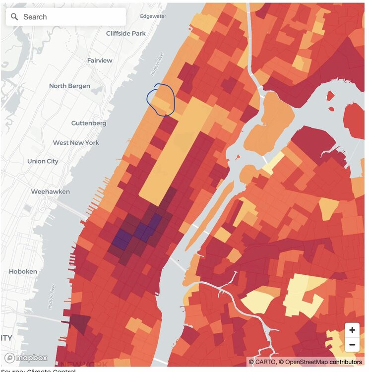
-
Sorry for the delayed response, just a little too much unfolding. House goes under contract. Inspection failed, contract withdrawn. Close to foreclosure, vehicle just as close to repo... SAD but true. I'm literally going to be on the street soon. I have lost everything with no solution.
-
the heaviest stuff is occurring right now lol
-
Suns coming out. Off to the torches!
-
Aw man I love that place. Great spot to just relax.
-
No I mean if we had precip coming down from the same direction (north) in the winter, even if it happened differently. I remember a couple of times we had surprise snowstorms in the winter when an arctic front came down from the north and stalled just south of us. February 1993 is one example, we got 4-7 inches of snow out of that (my favorite kind, all day snow that cleared right at sunset.) The other one was in February 1991 (if I remember this one correctly, my favorite snowstorm prior to January 1996), we had over 8 inches of snow during an arctic frontal passage that was never supposed to do anything except for a few rain showers changing to snow showers. The front stalled and a low formed just SE of the Hamptons and it snowed here for 36 straight hours (my longest snow event to this day-- thats why I loved this event so much and it was a complete surprise). It would have accumulated a lot more than 8 inches, but the snowfall during the day was while temperatures were 33-34, it really started accumulating at night and we were the bullseye. There was no snow west of Newark or east of the Hamptons. Boston and Philly got nothing.
-
We don’t get snow from a MCS
-