All Activity
- Past hour
-
 The Atlantic has been exceptionally quiet for a second consecutive September, but it looks as if the basin is trying to wake back up with a robust tropical wave heading through the tropical Atlantic. The wave, focused near 30W, is most likely still a few days away from consolidating and kicking off the process of tropical genesis, but with a strong model signal from operational/ensemble/AI models, and the wave producing much more convection than the failed development of 91L, this one looks like it will become a TC eventually. There are still some headwinds, figuratively and literally. In the image above you can see stable air to the northwest of the wave. Further west, there is wind shear evident with what little convection being blown over. Long term though, once this wave is able to consolidate, it will have a chance to intensify. Long way away from that however.
 -
If you use the seasons above that finish at 0-40 ACE for Sept (I doubt it will be that high or that low but 20 seems about right with some activity likely by month end), you end up with this much smaller group of La Nina seasons. 1942 (9.9 Sept) 1956 (9.4 Sept) 2007 (29.0 Sept) 2016 (27.3 Sept) Those are your 30-50 ACE June-Aug, with 0-40 ACE Sept La Nina years. Can narrow down more as September finishes. Very cold in the North & West in January of those years, fairly cold in December & March too. Feb very warm. As a reminder, 20 ACE would be a 100 kt sustained wind hurricane observation recorded at each of the six hour official advisory times...for five days in a row. Since 100 kts x 100 / 10,000 = 1 ace point (1 pt x 5 days x (24 hrs/6 hr space per observation) = 20). We may have the next Atlantic tropical storm in a day or two, but its already pretty far west to have a super long period as a major hurricane starting from nothing, if it develops. In a La Nina context, the 2017 September is useful anti-log - very low solar (we're very high now), very high activity September (175 ACE). You also had more of a classic hot West/cold East Summer (Jun-Aug) in 2017 which we didn't see this year. High solar is probably weakly correlated to inactive hurricane seasons long-term. But its a little hard to tell as we haven't had a whole lot of super high solar years (July-June) in recent times with the Atlantic warmer. July 2024-June 2025 finished at 149 sunspots/month, but prior ~peaks/near peaks have been well over 200-250.
-
Probably would have been a better backup than Rush who is a statue, but he thinks he is a starter so he was never going to be a Raven and sit behind Lamar.
-

September 2025 OBS-Discussion centered NYC subforum
donsutherland1 replied to wdrag's topic in New York City Metro
Here you go: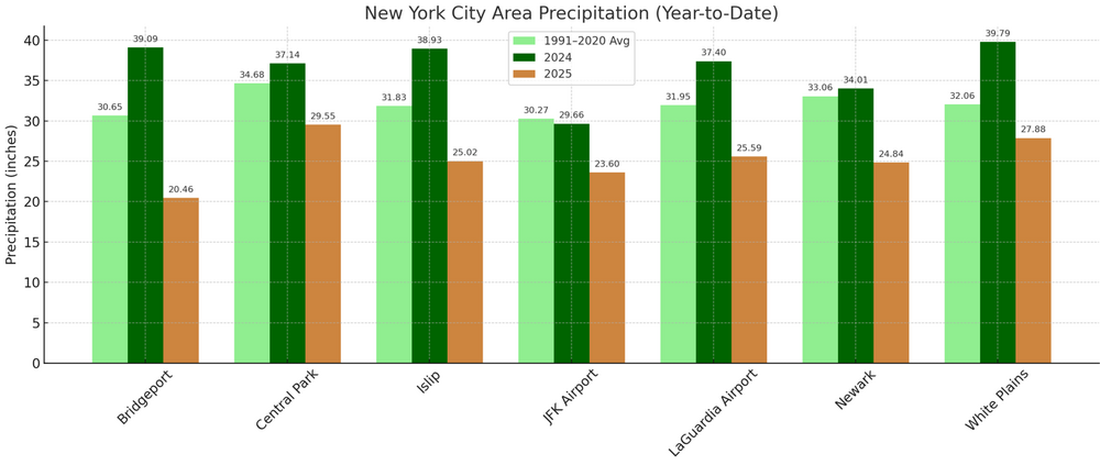

-
There should be some rain but I am still a bit skeptical of whether the heavier rain gets into the DC area given the gradient and potential track of the low.
-

September 2025 OBS-Discussion centered NYC subforum
MANDA replied to wdrag's topic in New York City Metro
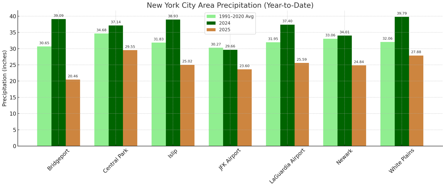
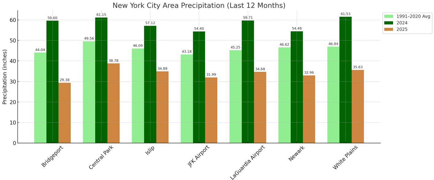
Hi Don- Can you do the same chart for Y.T.D. and 12 month rolling? If not too much trouble. I'd love to see what that looks like. Thanks- Mike -

September 2025 OBS-Discussion centered NYC subforum
SnoSki14 replied to wdrag's topic in New York City Metro
There's hints of a cool down for next weekend plus any coastal influence will keep highs down. No definitive fall like cool down yet though -
12Z runs regarding the MDR AOI: --GFS/CMC/Icon all have this eventually as a H with GFS/CMC both recurving well E of Bermuda (Icon doesn’t go out far enough to tell) -JMA has this as a TD at 48 and a TS at 72. This is stronger than the two prior 12Z runs that each had it as only a TD. -Waiting for Euro -UKMET again has this as a TS. This is a bit further W than recent runs but it’s still aiming a bit E of Bermuda as of 168: NEW TROPICAL CYCLONE FORECAST TO DEVELOP AFTER 72 HOURS FORECAST POSITION AT T+ 72 : 16.4N 47.4W LEAD CENTRAL MAXIMUM WIND VERIFYING TIME TIME POSITION PRESSURE (MB) SPEED (KNOTS) -------------- ---- -------- ------------- ------------- 1200UTC 17.09.2025 72 16.4N 47.4W 1006 40 0000UTC 18.09.2025 84 17.7N 48.8W 1006 42 1200UTC 18.09.2025 96 19.5N 52.1W 1006 44 0000UTC 19.09.2025 108 20.6N 54.3W 1006 40 1200UTC 19.09.2025 120 22.8N 55.1W 1006 44 0000UTC 20.09.2025 132 23.1N 57.0W 1005 43 1200UTC 20.09.2025 144 25.1N 57.7W 1003 46 0000UTC 21.09.2025 156 26.3N 58.6W 1001 49 1200UTC 21.09.2025 168 28.3N 59.3W 999 48
-
September 2025 OBS-Discussion centered NYC subforum
SnoSki14 replied to wdrag's topic in New York City Metro
Where have you been the last 10+ years -

2025 Atlantic Hurricane Season
WEATHER53 replied to BarryStantonGBP's topic in Tropical Headquarters
Just 10 days away -
Yeah. Nice to feel the dews.
.thumb.png.1c6792e49dd0a9d3abfb220e5a36919f.png)
- Today
-
BOS -2.5F ORH -1.6F PVD -3.5F BDL -3.0F A cool month so far Still feels great
-
It's pretty clear that there will be a tight gradient on the northern side of the precip shield Tuesday-Wednesday. For those of us north of DC, the question is whether we're in the decent amounts.
-
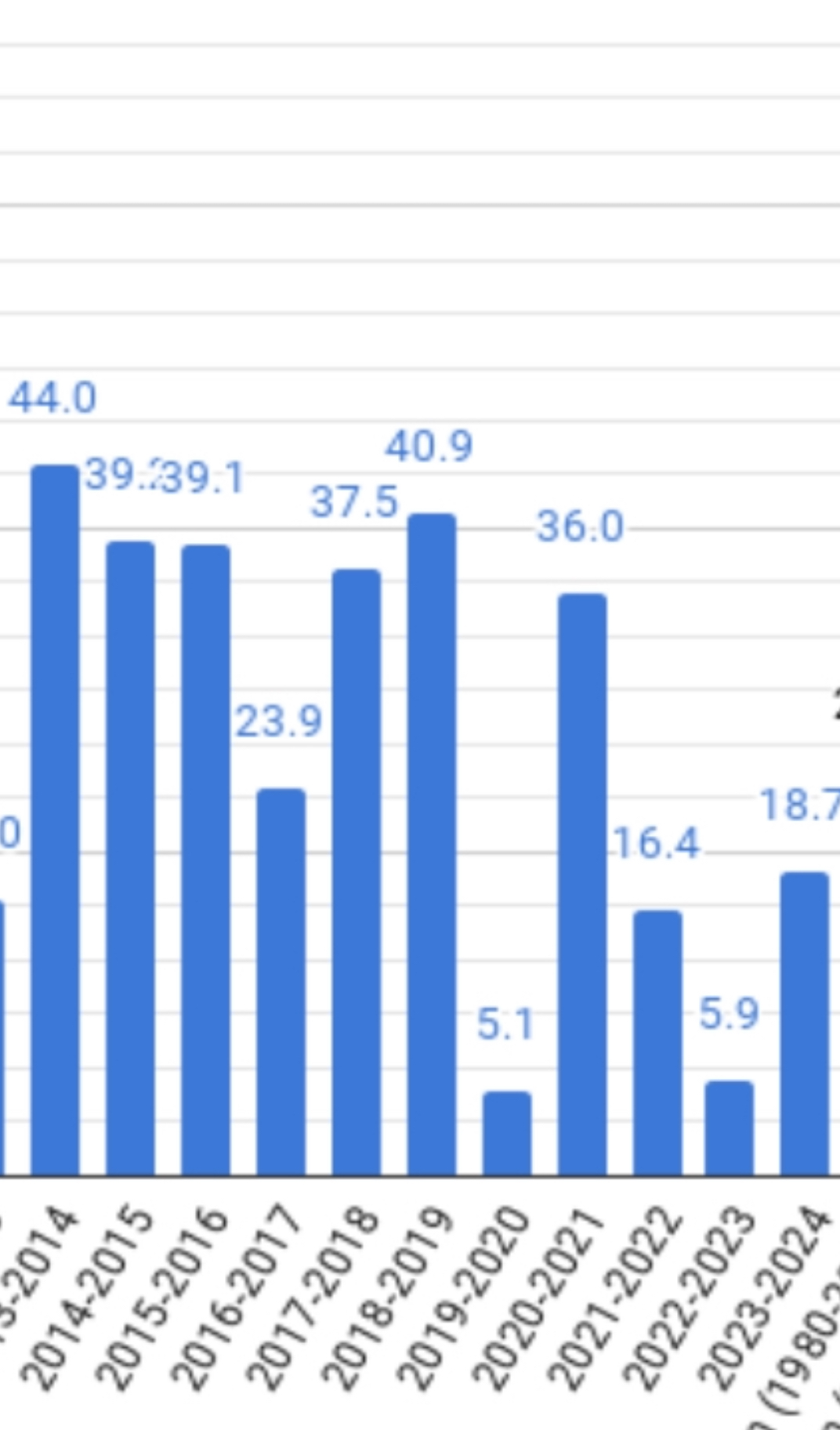
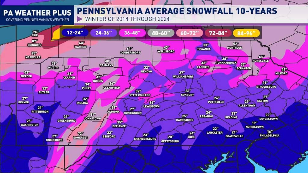
No reason to weep in my opinion. 6 seasons in the last decade featured above normal snow at MDT. That map above, for at least the Harrisburg area, is massively skewed by the 19-20 & 22-23 total clunkers.

-
September 2025 OBS-Discussion centered NYC subforum
donsutherland1 replied to wdrag's topic in New York City Metro
Despite the dry end to August, precipitation is running above normal in parts of the region through the first two weeks of September and much above the amount for last year in all areas. 2025 is September 1-13 precipitation, but none is expected today. While this does not ensure that the month will finish above normal, it is a welcome development.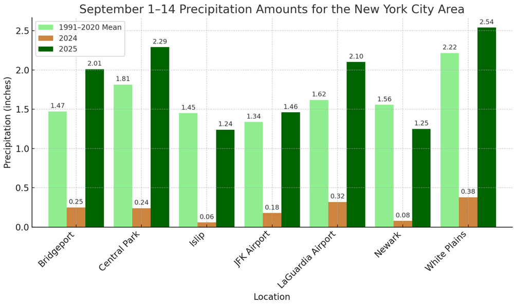
-
feels like summer today
-
Let us weep Sent from my SM-G970U1 using Tapatalk

-
Yeah the GFS may be overdoing (overdewing?) that, but with the dry ground there won’t be much modification. It’ll still be relegated to the typical cold spots mtns-north, but maybe a little more widespread than just the typical ASOS 32s? Maybe we get HUL in on it.
-
Nothing above a 30-40% chance of rain the next 10 days. This keeps up along with our talent in wind is going to create ripe conditions for a nasty forest fire Sent from my SM-G970U1 using Tapatalk
-

September 2025 OBS-Discussion centered NYC subforum
anthonymm replied to wdrag's topic in New York City Metro
Cold early September is a classic fake out. We don't truly shake summer off totally these days until like mid October. -
My hunch on low off NC is no but it is going to be interesting to watch it's track and see what it delivers to the Mid-Atlantic area in terms of rainfall and wind gusts. As for the MDR region feature I'd say if it happens it will be after 9/17. Things still look less than ideal for development in the MDR. Slower development is the better hedge IMO.
-

September 2025 OBS-Discussion centered NYC subforum
Sundog replied to wdrag's topic in New York City Metro
It's not out of the ordinary. -

September 2025 OBS-Discussion centered NYC subforum
nycwinter replied to wdrag's topic in New York City Metro
real summery feel outside this morning i cant believe in mid sept we are still having days like this.. -
They should leave you alone. It’s getting frozen out in another month or two anyway.


.png.2e3471e3d7775273558ebe06152cb4b2.png)