All Activity
- Past hour
-

Possible Record Breaking Cold + Snow 1/25 - 1/26
WeatherGeek2025 replied to TriPol's topic in New York City Metro
6-12 is a big hit it's not major but big -

January 25/26 Jimbo Back Surgery Storm
neverSnowsLCSC replied to Jimbo!'s topic in Southeastern States
Good. -
Throw the GEM, ICON, and GFS in the blender....good result.
-
Very keen to see the GEFS
-

Possible Record Breaking Cold + Snow 1/25 - 1/26
SACRUS replied to TriPol's topic in New York City Metro
-
When you view it as 2 separate systems..1) overunning snow looks almost locked..amounts will vary. 2) the second piece, is at the time frame where models have some divergence in evolution (old saying " we're at x hr where models lose it, to bring it back as we get closer". Where ever those 2 overlap is going to be in for a potentially historic ride.
-
I was thinking the same. The ZR was gone, but snow was missing. Somebody had to have been pasted on that run!
-
Both can be (and actually is) true. The evolution is definitely a bit south and phasing occurs a hair later, but verbatim it's still a big hit.
-
I'm not letting it get me down, but I hate when it does this
-
That GFS run would break snowfall records in every southern state except Tennessee.
-

Possible Record Breaking Cold + Snow 1/25 - 1/26
Jersey_Snowhole replied to TriPol's topic in New York City Metro
I wouldn’t say “big hit” -
Better than the GFS but this is not the type of storm the CMC tends to make big scores on. I like the CMC for major phasing events between the NRN/SRN streams or classic Miller As that result in deep surface lows. It can tend to be less reliable in this type of storm.
-

January 2026 regional war/obs/disco thread
40/70 Benchmark replied to Baroclinic Zone's topic in New England
As someone who is pessimistic on this weekend threat, I'm not worried about the GFS. -
This has no end in sight for a south trend. Ai GFS has been non stop moving south.
.thumb.gif.6787631db86e80892f89d1d40f76d12b.gif)
-
2-3" of QPF for all of East TN on that CMC run
-

January 25-26 Winter Storm Potential
Ralph Wiggum replied to Ralph Wiggum's topic in Philadelphia Region
It is, and maybe just noise, but there were big enough differences under the hood to make me raise an eyebrow. -

January 2026 regional war/obs/disco thread
CoastalWx replied to Baroclinic Zone's topic in New England
Shit ton of energy, digging on the backside of that trough too -
Interested to see the gefs. Hopefully the op doesn’t have too much support. There were quite a few members yesterday that showed exactly what the op just did.
-
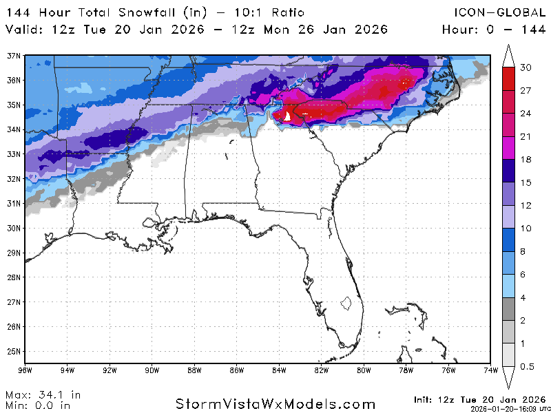
ICON 12z
-
100% this right here. All in the timing/phase, which also allows the flow overtop the MA to relax some with the delay to help it North. .
-
I was hoping with our 6z consensus we were out of the woods with the first phase handling out west. Agree that we still have to get through at least 0z tonight now... Additionally, the GFS coming to the normal solution before shifting back is worrying to me. Probably means we meet somewhere in the middle which would still be okay for us.
-
Possible Record Breaking Cold + Snow 1/25 - 1/26
WeatherGeek2025 replied to TriPol's topic in New York City Metro
cmc is a big hit -
GFS and GFSAI
-
The potential problem I see here. Is the HPs are a lot weaker 1032 vice 1040. The HP is exiting NE over Maine, which is allowing this thing to come NE more and potential ice for Dover. If the modeling continues to move this system NNE there might be others in the ice for a time period. At least that is my none educated observation.
-
It is 16 degrees at 2PM in Baltimore, and Ocean City is in the mid 40s


.gif.ee133f652baf6dbab6c4b00033d6f540.gif)


