All Activity
- Past hour
-
I see 2 little cells that popped up. One in Bergen one over Queens
-
Well that was an unexpected crash of thunder...
-
Some opening thoughts.
- 1 reply
-
- 1
-

-

2025 Atlantic Hurricane Season
WxWatcher007 replied to BarryStantonGBP's topic in Tropical Headquarters
Just going to make some blanket comments here. It's indisputable that there are numerous factors that determine whether a season is active or not. SSTs and OHC are just one piece of the puzzle and I think @cptcatz is right that they're often leaned on too much, but they are still a significant piece. SSTs should warm up some, as mentioned by the discussion earlier. That's not really where my caution flag lies. For me it's not just the tropical Atlantic SSTs that are important, the subtropics as well. This distribution has me concerned that the stability issues we've seen this decade will persist into the 2025 season. Now, that hasn't proven to stop the exceptional stretch of activity we've seen since 2017, but it's something to pay attention to considering possibly less ideal atmospheric conditions this season with the lack of a full blown Nina. We only need to look at last season and the historic lid that was placed on the entire basin due to SAL and systemic stability reinforced by an active AEW train as an extreme example of what can happen. Is there anyone willing to say right now that 60W to 20W won't have at least some problems with SAL and stability? There are still open questions about the WAM, how much the Pacific cools, and the actual ENSO that controls this summer/fall. I don't think it's unreasonable at all to throw up caution flags, even while leaning toward another above normal season. I don't think that's "mainstream" or whatever, it's looking at the evidence right in front of us. @jconsor, agree that the S&P forecast is interesting, though I am still skeptical of those kind of LR forecasts and their skill. Doesn't mean the science isn't being pushed forward though, which would be awesome to see. I do agree that we probably have a higher than normal likelihood for an active landfall season, but I'm not willing to paint landfall zones because idk if the skill is truly there outside of a month at most. @GaWx, I don't think we need SSTs to approach the last two years for a higher end NS season, but I do think we need an expansive region of high OHC for this year to produce higher end H and MH numbers. That's there, though not nearly to the extent of the prior two years. -
GFS likes Saturday afternoon
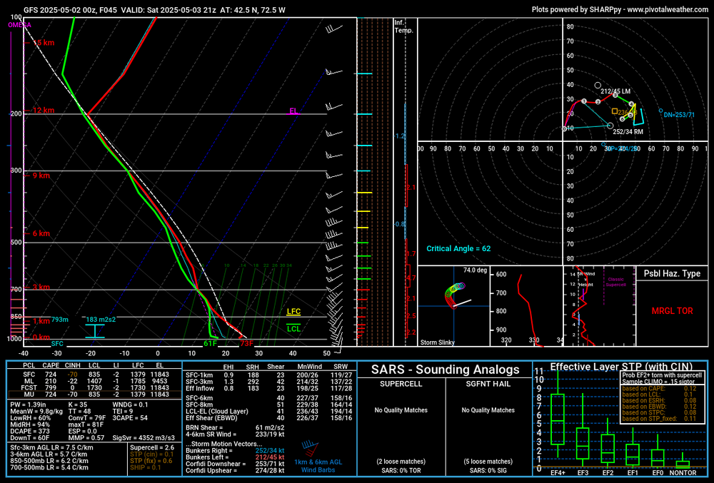
-
5" over a few days would actually be quite beneficial. We all know what normally happens on LI in the summer. Also we have to see how it evolves. Could be a few days of mostly raw misty crap on easterly wind while the real rain is west.
- Today
-
Griffin often gets stuff the airport doesn't, Shack Of course the airport often doesn't know what's happening all round it, lol. Hope all is well with you!!
-
May has arrived and preseason is here! That means it's time for the legacy thread. The Atlantic has been exceptionally busy since 2017, but it has thrown several curveballs over that period that has led to unexpected outcomes in the basin. Last year, after the earliest category 5 hurricane on record, we saw a historically quiet start to the climatological peak of the season, followed by a historically active back loaded season. This year, we do not have the same warmth and depth across the basin as 2024, but with a neutral to cool neutral ENSO likely--which would facilitate periods of low wind shear, a cooling Pacific, and still warm SSTs in the western Atlantic, another average to above average season is likely IMO. However, a major thing to watch is the cooler SST distribution in the tropical Atlantic which may not only temper the ceiling in that part of the basin, but also potentially continue the dramatic stability issues we've seen this decade. Last year, I was in Texas for Beryl, Louisiana for Francine, and Florida for Helene. The Gulf has been ground zero since 2017. We'll see if that continues this year. Beryl was the first storm where I had my window blown in Francine nudged east at the last minute and I missed the worst. Still a solid storm. Helene was the real deal. With 2024 in the books, I've now completed 16 tropical chases.
- 1 reply
-
- 2
-
-

2024-2025 La Nina
Stormchaserchuck1 replied to George001's topic in Weather Forecasting and Discussion
My last biggest storm was 5.5" on Nov 15, 2018. Can you believe that. I also think every year has been below average since 15-16. There was a some major warming happening though around the perimeters in 14-15 and 15-16.. Dec 15 was record warm. 14-15 was record warm in the West. And last Winter had the opposite: some cold around the perimeters. Hopefully we are changing into a better pattern for the next few Winters. -
I fervently hope you guys get happily buried ALIVE in powder snow soon!
-
Looks like the rain is later Saturday, I have a dumpster to clean the house out to get ready for sale and don't want rain Saturday morning or early afternoon.
-
@weatherwiz might like the 3k NAM for Saturday

-
Has pollen seemed way worse this spring than years prior to anyone else?
-
One more

-
Thanks, I always miss the ones I lose but then I rescue another, she's from Mississippi, 12 weeks old, house broken, very trainable and just a sweet girl.
-
Sorry for the loss of your long time companion, but that dude also looks like he’s ready for a good life.
-
There likely will be a period where it is dry on Sunday.
-

E PA/NJ/DE Spring 2025 Obs/Discussion
Albedoman replied to PhiEaglesfan712's topic in Philadelphia Region
Missed again tonight. Had to water-Its been a long time since I had to water a garden on the first day in May. The Blue Mts are absolutely destroying every cell that comes near them. Just incredible. -
-

-
I’ve come to fully accept cold season QPF deficits followed by QPF bull’s-eye for warm season. I guess I won’t do any planting this week because seeds will be washed away and roots will rot.
-
I gave up too, years ago, I've had 4 females, and they always burn spots. I lost my dog of 15 years a few weeks ago but adopted an awesome puppy last week. I wish I could post the pic but having troubles. Edit: did it
-
88.9 at 3:50pm
-
High: 90.8 on 4/4! (90.4 on 4/30) Low: 37.0 on 4/13. Precip: 2.00"
-
Is Sunday looking like an all day washout or moreso afternoon?


.thumb.png.4150b06c63a21f61052e47a612bf1818.png)

