All Activity
- Past hour
-
-
Looks like a warm start to September heading later into the first week. Hopefully a Septorcher to remember.
-
Nah we had that two weeks ago when it was 88-94 for days.
-
Back to normal. Going to be a great 3 days stretch. Best of the summer?
-

E PA/NJ/DE Summer 2025 Obs/Discussion
BBasile replied to Hurricane Agnes's topic in Philadelphia Region
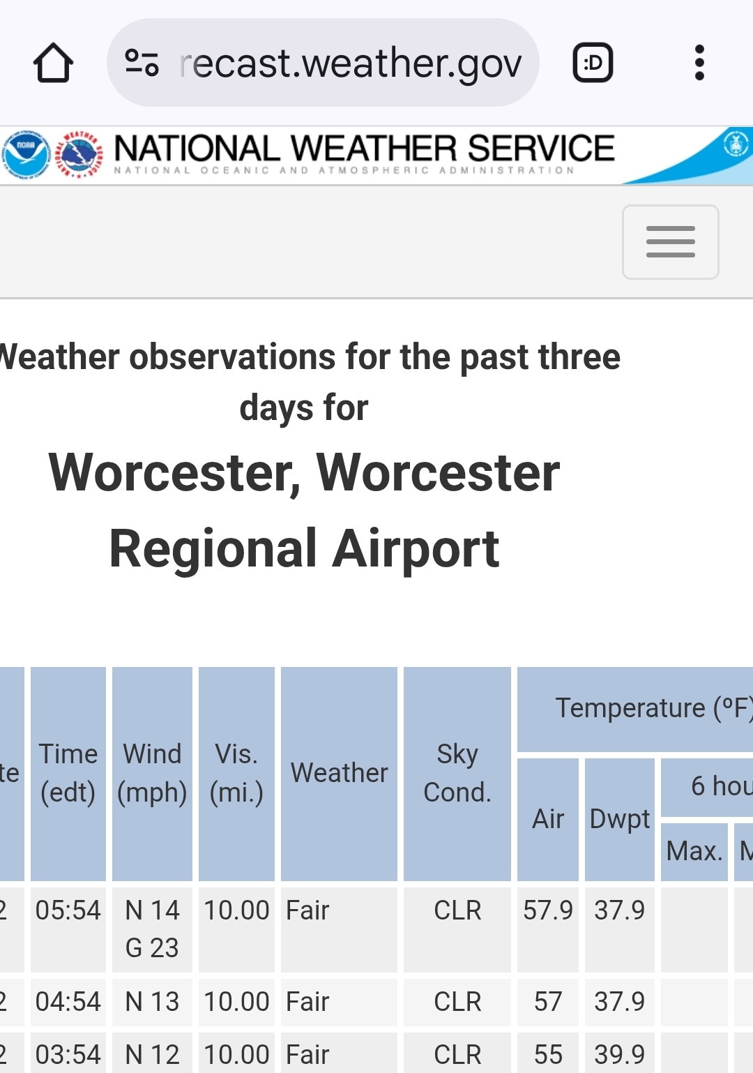
Hit a low of 55.9F this morning. Perfect. -
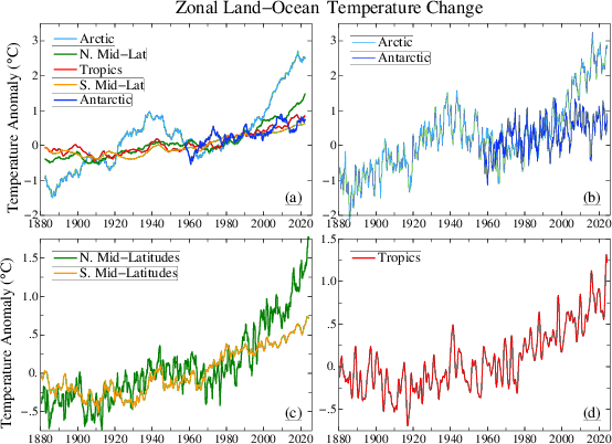
After several decades of rapid warming, arctic warming ground to a halt in the past 10-15 years. while warming in the NHemi mid-latitudes sped up. Consistent with recent trends in arctic sea ice and our recent winters.
-
80s today. Summer is back baby.
-
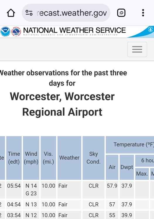
 49.8 for the low, so close to first 40s of the season but 50 goes in the books. KMGJ just up the road did get officially into the 40s.
 -
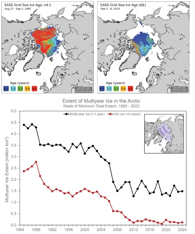
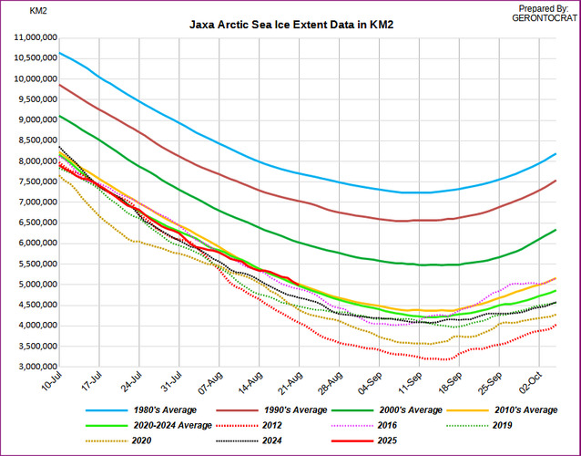
Looks like another season ending in the 4-5 sq million range for September average extent. Years like 2012 and 2020 dropping under 4million sq km have been the exception. So have years finishing over 5 million sq km like 2009, 2013, and 2014. So a very stable September minimum regime since the record declines back in the strong 2007-2012 dipole era. This reversal of the dipole has prevented us from exceeding the 2012 minimum so far. So we can say with confidence that 2007 lead to a regime shift in the sea ice. Extent and thickness have not been able to recover to the much higher pre-2007 ice. Even with multiple summer seasons with very favorable lower pressure circulation patterns for sea ice retention. The annual warmth in the Arctic has just been too strong to allow any type of recovery. 2024…..4.38 2023…..4.37 2022….4.87 2021……4.92 2020……3.92…2nd lowest 2019……4.32 2018…...4.71 2017……4.87 2016……4.72 2015…..4.63 2014…..5.28 2013…..5.35 2012…..3.60….lowest 2011……4.61 2010…..4.90 2009….5.36 2008….4.67 2007…..4.28 https://agupubs.onlinelibrary.wiley.com/doi/full/10.1029/2024GL114546 A regime shift is an abrupt, substantial, and persistent change in the state of a system. We show that a regime shift in the September Arctic sea-ice extent (SIE) occurred in 2007. Before 2007, September SIE was declining approximately linearly. In September 2007, SIE had its largest year-to-year drop in the entire 46-year satellite record (1979–2024). Since 2007, September SIE has fluctuated but exhibits no long-term trend. The regime shift in 2007 was caused by significant export and melt of older and thicker sea ice over the previous 2–3 years, as documented in other studies. We test alternatives to the traditional linear model of declining September SIE, and discuss possible explanations for the lack of a trend since 2007. Current Jaxa extent
-
 56 degrees here this morning
 -
-
 Central Park has fallen into the 50s for the third time this month. The last August with three or more such days was August 2007 with six days. The three consecutive such days are the first such streak since August 20-22, 2007.
 - Today
-
This forecast is going on the chamber of commerce masthead.

-
No need for AC but might have to turn on the humidifier. A doodle day.
-
I guess the silver lining as we approach the end of arctic sea ice melt season in the next 3 weeks is that although it’s record low, we aren’t as low as the all time record low in 2012: And still all systems go for a solid -IOD event:
-
55/58 here. Best news is I see the sun. Glorious!
-
 Enjoying the cooler weather here as my area made it to #2 on the all-time 90° day list this year at 15 days. Time Series Summary for NEW HAVEN TWEED AP, CT - Jan through Dec Top 5 years for 90° days Click column heading to sort ascending, click again to sort descending. 1 2022 17 0 2 2025 15 132 3 2010 14 0 4 1977 13 100 5 2021 12 0 - 2020 12 2 - 2012 12 3
 -
-
-
49.8° We take in Jan
-
46.2 we take!
-
Just a little something for all the ruckus in here this month,
-
Only hit 71 today. The record low maximum temperature is 67 back in 1930. Still, mid-to-late August is just way too early for back-to-back days of overcast skies, for sure.
-

Hurricane Erin: 105 MPH - 945 mb - NNE @ 17
GaWx replied to BarryStantonGBP's topic in Tropical Headquarters
Erin’s ACE is now crossing 32 and is headed to ~34 for its likely total. That’s pretty impressive and it has brought 2025 ACE up to 12th highest for the date of the last 75 years. -
2AM TWO: up slightly from 50/50 to 50/60: 2. Central Tropical Atlantic (AL99): Showers and thunderstorms associated with a tropical wave located about a thousand miles west-southwest of the Cabo Verde Islands remain well organized. This system could become a tropical depression at any time, but the latest satellite-derived wind data indicate that the system does not have a well-defined circulation center. The system is expected to move into a less conducive environment later today through Saturday, but could reach a slightly more favorable environment again late this weekend into early next week as it moves westward at 10 to 15 mph over the central tropical Atlantic and approaches the Lesser Antilles. * Formation chance through 48 hours...medium...50 percent. * Formation chance through 7 days...medium...60 percent ————— There’s lots of wx bb chatter that suggests this is already a TC. Hmmm.