All Activity
- Past hour
-

December 2025 regional war/obs/disco thread
40/70 Benchmark replied to Torch Tiger's topic in New England
Unreal that it went from a rain event to a whiff. -
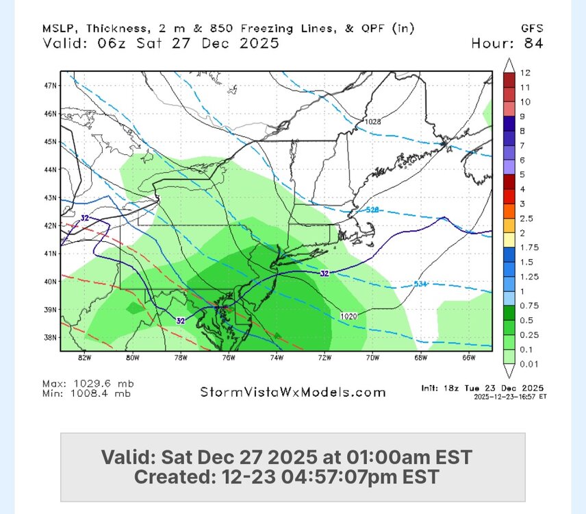
Sleet bomb continues on gfs. .75” qpf all sleet for me on gfs. Joy lol
-

December 2025 regional war/obs/disco thread
Snowcrazed71 replied to Torch Tiger's topic in New England
We still have tomorrow and Thursday and most of the day Friday before the system comes into the area. Most seem to be writing this off because of the southward push on the models. I'm not saying this is definitely going to come north again, but there's a good chance that it will tick back North again, and even to a point where we're all in the game. I would say if this doesn't change by Thursday evening, it's a goner. -
As far as I'm concerned, it's been gone at least 24 hours with the steady trend of the cold press. Like Will said, we need to see a reversal tonight... or it's gone
-
18z GFS holds! Best news of the last 3 minutes.
-

E PA/NJ/DE Winter 2025-26 Obs/Discussion
Duca892 replied to LVblizzard's topic in Philadelphia Region
Gonna be one of those storms where you get 1-3in of snow and then a nice concrete layer of sleet on top. Yuck yuck yuck -

December 2025 regional war/obs/disco thread
weatherwiz replied to Torch Tiger's topic in New England
Someone in PA is going to get some significant icing. I don't see much room for this to get any farther north but SW CT may still be in the game for accumulating snow. -
AI gfs is further south. Almost a scraper. Gfs is north. Nice hit.
-
2025-2026 ENSO
40/70 Benchmark replied to 40/70 Benchmark's topic in Weather Forecasting and Discussion
I guess, hardly. -
lee goldberg had 3-6 inches for nyc in friday/saturday storm
-
(002).thumb.png.6e3d9d46bca5fe41aab7a74871dd8af8.png)
E PA/NJ/DE Winter 2025-26 Obs/Discussion
ChescoWx replied to LVblizzard's topic in Philadelphia Region
NAM 12km has the start of the sleetfest after a couple inches of snow - verbatim could be 2" to 4" of snow/sleet before any change to ZR....but alas that will change a lot by Friday! -
67 at 3:03pm. Walked the dog in shorts.
-
2025-2026 ENSO
40/70 Benchmark replied to 40/70 Benchmark's topic in Weather Forecasting and Discussion
-NAO/+PNA, +NAO/-PNA has been the theme last 10 years or so... -
A weak system brought some light snow to the region. Snowfall amounts included: Armonk: 3.2" Bridgeport: Trace Islip: Trace Middletown: 5.0" New York City: Trace The snowfall in New York City was in line with historical data for systems with low temperatures above freezing. In New York City, only 25.6% of storms had seen measurable snowfall with a daily low of 33° or above with just 9.2% seeing 1" or more snowfall. Almost three-quarters (74.4%) of such events saw only a trace of snowfall. Today had a low temperature of 35°. 91.4% of snow events with a minimum temperature of 35° or above saw a trace of snow. Another system could bring precipitation on Friday into Saturday. This system could be a more substantial system with the potential for a plowable snowfall in the New York City region. No exceptionally cold or warm weather appears likely for the first week of astronomical winter. Nevertheless, the closing days of December will likely be colder than normal. December 2025 will likely finish with a maximum monthly temperature below 60° in New York City. The last time that happened was in 2019 when the monthly high was 58°. If 2025 has a monthly high below 60°, that would be only the fifth such occurrence since 2000 (2003, 2004, 2005, and 2019 are the cases since 2000). The ENSO Region 1+2 anomaly was -0.6°C and the Region 3.4 anomaly was -0.8°C for the week centered around December 17. For the past six weeks, the ENSO Region 1+2 anomaly has averaged -0.40°C and the ENSO Region 3.4 anomaly has averaged -0.68°C. La Niña conditions will likely continue through at least mid-winter. The SOI was +12.61 today. The preliminary Arctic Oscillation (AO) was +1.312 today. Based on sensitivity analysis applied to the latest guidance, there is an implied near 100% probability that New York City will have a cooler than normal December (1991-2020 normal). December will likely finish with a mean temperature near 34.0° (5.1° below normal). Supplemental Information: The projected mean would be 3.4° below the 1981-2010 normal monthly value.
-
Christmas clipper maybe juicing up a bit?
-
It’s different world there similar to NW Maine.
-

2025-2026 ENSO
PhiEaglesfan712 replied to 40/70 Benchmark's topic in Weather Forecasting and Discussion
This map is very reminiscent of fall/winter 2010-11. Of course, we had a very relaxed Pacific jet that year, which explains why we went cold in the East all the way through December and January, despite their being a deep -ENSO/-PDO/-IOD. Even when things moderated out in February and March 2011, those months weren't particularly that much warmer than average. (We eventually got the warmth that year, from April-July.) We don't have a relaxed Pacific jet this year (at least I don't think), so I'd be shocked if went cold all of January. I expect a reversion to the mean, and a torch to start at some point in January, continuing into February. -

White Christmas Miracle? December 23-24th
Torch Tiger replied to Baroclinic Zone's topic in New England
Light snow/mix a bit too, rate dependent. @work chelmsford -
E PA/NJ/DE Winter 2025-26 Obs/Discussion
ChescoWx replied to LVblizzard's topic in Philadelphia Region
Sleet fest which is better than ZR for sure! -
True, we never know when 92 (or was it 91? ) will come through the door again, but it will
-
White Christmas Miracle? December 23-24th
weatherwiz replied to Baroclinic Zone's topic in New England
Well after today I still need 94.5" to hit 100 -
Underway here now, -SN, 30/24F
-

White Christmas Miracle? December 23-24th
ORH_wxman replied to Baroclinic Zone's topic in New England
Actually getting some good flakes now here. 33F Not gonna last though. Gotta wait until after 00z here. Up by Ray could get some accumulation from this batch. -
Well said it worked, hey I’m first to admit I’m glad he’s looking dead wrong! Let’s start with a good pattern and hope it’s not just feet and feet of pattern lol
-

White Christmas Miracle? December 23-24th
WxWatcher007 replied to Baroclinic Zone's topic in New England
The sun is setting, the temperature is falling, and the radar continues to look good. Will measure again in a few hours when I clear the snow board. What I do know is that I'm now over 50" for the season. Just an unbelievable run here. This is my first season with over 50" imby since 2012-13. Winter 2013-14 through 2017-18 were in DC. Winter 2018-19 to now have been in CT.


