All Activity
- Past hour
-
My layman's understanding is that we don't want the low to phase too early or too strongly or else it will punch through the high and cut. If it holds back to the west that is more likely to happen.
-

Possible Record Breaking Cold + Snow Sunday 1/25 - Tuesday 1/27
lee59 replied to TriPol's topic in New York City Metro
No matter what happens with snow accumulations from this storm, it should stick around a while with all the cold air behind it. Not the case with many big storms we've had. -
Better to keep the high in place and not phase as much if the energy is more separated.
-
Always. 3k is great for that. Find the mix line and add 10-20 miles north and it’s pretty dang good
-

January 24-26: Miracle or Mirage JV/Banter Thread!
mappy replied to SnowenOutThere's topic in Mid Atlantic
Looks like only Randy’s stayed -

January 24-26: Miracle or Mirage JV/Banter Thread!
bncho replied to SnowenOutThere's topic in Mid Atlantic
Might be because you're from PA. I still welcome you! -
18z run of GFS will be interesting…
-
 Happens all the time. Everyone acts like where they are is where everyone is. No concept the forum runs a general 75 mile radius north south east and west of Central Park.
 -
NAM was primed man. Like primed. and a 1043 H just north of us.
-
I like how this .ap looks with that 1043 HP positioned. That would keep any ice from come up to DC, Baltimore and Delaware. I would think. Maybe after some good sampling things will look more in line with this setup. We have seen a lot of possibilities this morning and now the 18z's.
-
So what is the importance of it being more east again?
-

Possible Record Breaking Cold + Snow Sunday 1/25 - Tuesday 1/27
TriPol replied to TriPol's topic in New York City Metro
Virga really isn’t a concern in a setup like this. Yes, the antecedent air mass is dry, but this is a deep, dynamically forced system with strong large-scale lift. Once precipitation starts, the column moistens very quickly. Virga issues tend to happen with weak forcing, shallow lift, or fast-moving systems trying to overcome dry air. A closed H5 low with sustained ascent overwhelms that problem. You might lose the very first echoes to evaporation, but not the storm itself. -
Looks like surface temps are closest to the GFS at this point.
-

January 24-26: Miracle or Mirage JV/Banter Thread!
TSSN+ replied to SnowenOutThere's topic in Mid Atlantic
So why’s my comment about the 93z thing deleted but the others stayed? -
things seems to be zeroing in on a solid to major hit for the southern and eastern portions of the sub would need a real nice needle threading to get the goods this far nw and that's looking less likely than 12 hours ago imo
-
Possible Record Breaking Cold + Snow Sunday 1/25 - Tuesday 1/27
TriPol replied to TriPol's topic in New York City Metro
From H5 (500 mb) height, we are looking at exactly the setup that has a high potential (high ceiling) for the NYC area for a major winter weather event. The ECMWF depicts a then fully closed 500mb low in the Northeast with large negative height anomalies and a slow pivoting flow. It represents a true 500 mb closed low, that is no longer open or progressing as a trough. It is vertically coherent, dynamically mature and no longer associated with the fast zonal flow of upper levels. The closed 500mb low will eventually be around for a period of time, not a question mark of how long. A compact and centered cold pool aloft is also critical to snow production efficiency. Closed mid-level lows create steep lapse rates, which in turn create significant lift and space throughout the region to support snow band formation, and through the mesoscale process create the large snowfall totals in NYC. Most storms that produce over 18 inches of snow are not continuous, steady snowfall, rather they are created by the time and conditions that create the most snow through banding.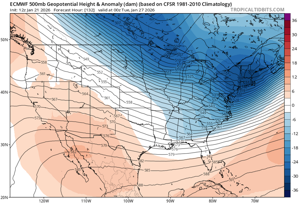
-
Nam might have delivered with weenie extrapolation.
-
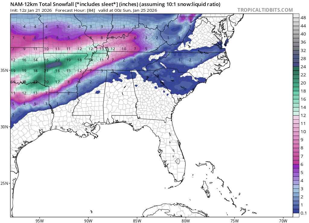
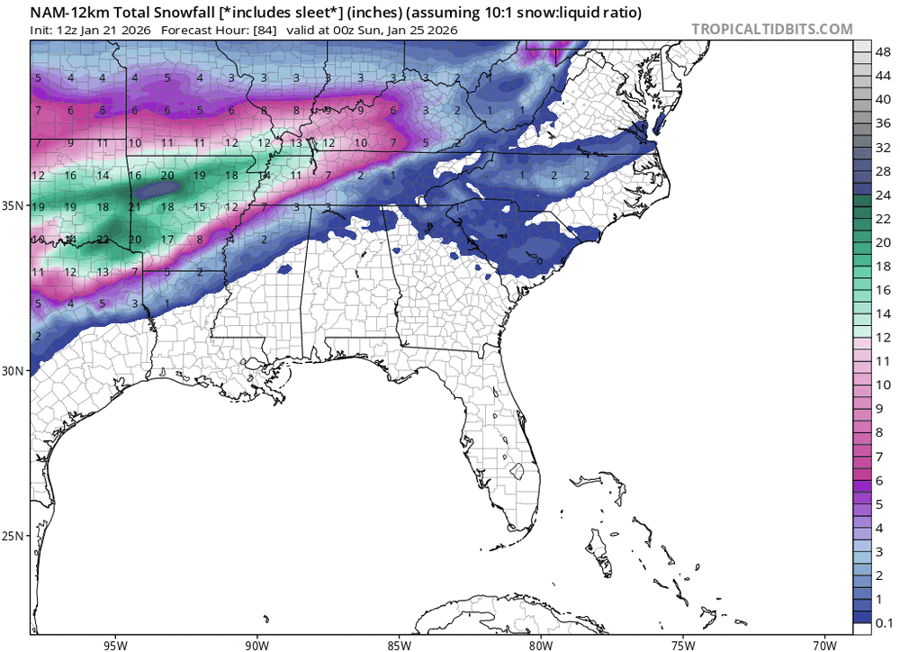
Only to 78 hours here, but a good trend based on surface output. Ignore the numbers as this is probably sleet.
-

January 24-26: Miracle or Mirage JV/Banter Thread!
H2O replied to SnowenOutThere's topic in Mid Atlantic
This is the way -

January 24-26: Miracle or Mirage JV/Banter Thread!
Maestrobjwa replied to SnowenOutThere's topic in Mid Atlantic
AND CLIMBING!!!! *should totally start using DBZ terms to describe the storm* -

Possible Record Breaking Cold + Snow Sunday 1/25 - Tuesday 1/27
NEG NAO replied to TriPol's topic in New York City Metro
I just mentiond that a few minutes ago and with this arctic airmass I would suspect there will be virga -
The 18z NAM is better than the 12z and was about to obliterate us...and that is the end of my analysis of the NAM at 84 hours.
-

January 24-26: Miracle or Mirage JV/Banter Thread!
yoda replied to SnowenOutThere's topic in Mid Atlantic
ITS OVER 9000!!!! -

Central PA Winter 25/26 Discussion and Obs
WmsptWx replied to MAG5035's topic in Upstate New York/Pennsylvania
WGAL on the record saying 12 or more likely. -
.thumb.png.4150b06c63a21f61052e47a612bf1818.png)
“Cory’s in LA! Let’s MECS!” Jan. 24-26 Disco
HIPPYVALLEY replied to TheSnowman's topic in New England
Given the stretch we’ve had the past few years I think most on here should be happy that we are probably going to be able to lock in at least 6”- 10” for most of the SNE forum. If it’s more than that great but I for one won’t be complaining about missed potential if I “only get” 8”.