All Activity
- Past hour
-
Yeah a lot of good people went over there.
-
He has a YouTube channel now as well as Facebook and a X account.
-
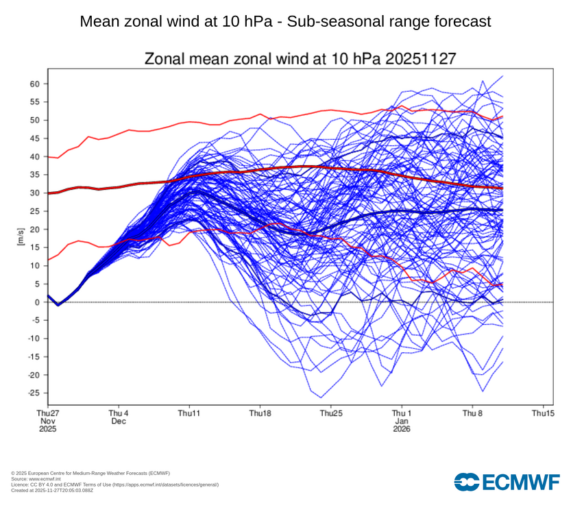
Ummm Its strange, it took one model run for several SS media folks to think they had the strat all figured out after one forecast spike: "Brief SSW, then raging SPV coming." 3 days of weakening trends & no one but one SS media guy saying anything or correcting. SPV is giving everyone the middle finger.
-
Amen brother!!!
-
Enjoy the company of the people you love! .
-
Tomorrow and Saturday will be unseasonably cold days. Tomorrow will be windy with a possibility of some snow flurries. There is potential for New York City's Central Park to experience its first freeze of 2025 tomorrow or, more likely, Saturday morning. The 1991-2020 normal first date is November 21. The 1961-1990 baseline was November 11. Last winter's first freeze occurred on November 30. Saturday and Sunday will see a snowstorm blanket parts of the Great Lakes Region. Chicago and Milwaukee could see 6"-12" of snow. Detroit could pick up 4"-8". Toronto could see 3"-6". Sunday and Monday will turn somewhat milder. Showers are possible on Monday as a cold front moves across the region. Generally colder than normal conditions could then continue into or through the second week of December. Severe cold appears unlikely through at least the first 10 days of December. Moreover, a storm could affect the region on Tuesday into Wednesday, bringing 0.50"-1.50" precipitation to the region. There is a distinct possibility that New York City could see its first measurable snowfall of the season. Interior sections have the highest probability of seeing accumulations of snow. The ENSO Region 1+2 anomaly was -0.7°C and the Region 3.4 anomaly was -0.7°C for the week centered around November 12. For the past six weeks, the ENSO Region 1+2 anomaly has averaged -0.16°C and the ENSO Region 3.4 anomaly has averaged -0.65°C. La Niña conditions will likely continue through at least mid-winter. The SOI was +1.97 today. The preliminary Arctic Oscillation (AO) was +0.036 today. Based on sensitivity analysis applied to the latest guidance, there is an implied 96% probability that New York City will have a cooler than normal November (1991-2020 normal). November will likely finish with a mean temperature near 47.1° (0.9° below normal). Supplemental Information: The projected mean would be 0.6° below the 1981-2010 normal monthly value.
-
0-15 inches? Sounds like a CWG forecast
-
Oh okay then (this afternoon AFD from LWX) LONG TERM /SUNDAY THROUGH THURSDAY/... A more active weather pattern is likely to build over region late this weekend and continue to the early parts of next week bringing multiple chances for wintry precipitation. The first chance in the long term period for wintry precipitation will occur Sunday into early Monday morning as a strong sfc low passes to the north with it`s attending front moving through our region on Sunday. As precipitation associated with the front moves into the region, cold air in place ahead of the boundary may allow for some front end wintry precipitation. Additional wintry precipitation will be possible on the back end side of the front as cold air rushes into the region. Model guidance continues to have considerable spread on precipitation types with freezing rain and snow possible. Based recent trends,the best chance for impactful wintry precipitation at this time will likely be in areas along and west of the I-81 corridor. A brief lull in precipitation is likely on Monday, but a strong coastal low passing to the south of the region will bring another round of precipitation to the region Tuesday into Wednesday. Weather models have a range of solutions for the Tuesday event with some solutions having a combination heavy rain and some wintry precipitation and other solutions indicating the chance for a decent accumulating snow event. National Blend of Model plume graphics really shows the uncertainty with snow solutions ranging from 0 inches to near 15 inches of snow. At this time, we continue to have low confidence in the wintry threat early next week, but it`s a period of note worth keeping an eye on for planning purposes. &&
-

December 2025 Short/Medium Range Forecast Thread
jaxjagman replied to John1122's topic in Tennessee Valley
https://x.com/i/status/1993894442328375446 Check out his winter forecast -
happy thanksgiving everybody hope you get to enjoy it with your families!
-

December 2025 regional war/obs/disco thread
Torch Tiger replied to Torch Tiger's topic in New England
Time to fire up a thread! Its a lock! -

Nov 28-30th Post Turkey Day Wintry Potential
hawkeye_wx replied to Chicago Storm's topic in Lakes/Ohio Valley
Can always count on the 18z NAM/3kNAM to go extra weenie. -

Nov 28-30th Post Turkey Day Wintry Potential
andyhb replied to Chicago Storm's topic in Lakes/Ohio Valley
IIRC that wave had a deepening trend closer to verification as well as the PV lobe became better resolved, I remember having some back and forth with @RCNYILWX about it at the time. The issue this time is that the upstream ridge isn't quite as amplified as that, and there's a bit more phasing required here for a higher end outcome. -

December 2025 regional war/obs/disco thread
TauntonBlizzard2013 replied to Torch Tiger's topic in New England
I don’t believe the euro verbatim either, but that is what it currently shows. -

November 2025 general discussions and probable topic derailings ...
ma blizzard replied to Typhoon Tip's topic in New England
18z 3k NAM / HRRR on board -

Nov 28-30th Post Turkey Day Wintry Potential
weathafella replied to Chicago Storm's topic in Lakes/Ohio Valley
Clown range 18z NAM shows a trend to have better mid levels. That can really improve output regardless of modeled qpf (which is decent as is). -

Nov 28-30th Post Turkey Day Wintry Potential
Chicago Storm replied to Chicago Storm's topic in Lakes/Ohio Valley
This is a very good and valid point. -

Pittsburgh PA Fall 2025 Thread
PghPirates27 replied to TheClimateChanger's topic in Upstate New York/Pennsylvania
I’d actually take that Euro lol -

December 2025 regional war/obs/disco thread
40/70 Benchmark replied to Torch Tiger's topic in New England
This. -
December 2025 regional war/obs/disco thread
40/70 Benchmark replied to Torch Tiger's topic in New England
Chase this? Jesus, sign of the times... -
December 2025 regional war/obs/disco thread
40/70 Benchmark replied to Torch Tiger's topic in New England
Sell. -
Am at Thanksgiving family dinner. If All goes well one or two threads will begin 9pm tonight or7am Friday. If it’s snow it will be for odds on CP first measurable snow sleet No time to elaborate right now. Have a wonderful family dinner. Walt
-
December 2025 regional war/obs/disco thread
TauntonBlizzard2013 replied to Torch Tiger's topic in New England
I don’t disagree. I won’t believe it until it’s happening. But all we can do is look at modeling today. And some do give us snow. All you can say -

Nov 28-30th Post Turkey Day Wintry Potential
jlauderdal replied to Chicago Storm's topic in Lakes/Ohio Valley
Eye candy that won't materize, GFS does this in the tropics on a regular basis. Heavy rain at my place ahead of a cold front, last rain and 80s I will see for a few days. I'm holding my 7.5 prediction for Western burbs. One more shot to adjust tomorrow. -
We wait until we see the whites of the weenies.


