All Activity
- Past hour
-
Love the nostalgic turn this thread has taken. My journey was AccuWx —> Bill Evans board —> Tristateweather —> Eastern —> Here. Anyone remember a poster on the Bill Evans board named “hani345.” They lived in Newburgh and would always post punctuation-free sentences like: “Bill how windy is it gonna be please Bill I’m scared….”
-
we all get to have drought!
-

Another Coating of Snow Saturday - "It's all we Got"
40/70 Benchmark replied to Sey-Mour Snow's topic in New England
3.25" Nice event. -

Storm potential January 17th-18th
Northof78 replied to WeatherGeek2025's topic in New York City Metro
Yup, all of NY CWA is now upped to 3" - 5" -

First Legit Storm Potential of the Season Upon Us
8611Blizz replied to 40/70 Benchmark's topic in New England
Looks like BOX caught up with the AI's?
-
It's close some lake effect snow and a couple of sprinkles over Florida.

-

January 18th Back Door NW Trend Snow OBS Thread
shadow_ replied to Mikeymac5306's topic in Philadelphia Region
Just posted wwa for lehigh valley for 2 to 4..seems like deja vu for yesterday last minute maybe we end up with 5 to 6 again. -

January 2026 regional war/obs/disco thread
OrangeCTWX replied to Baroclinic Zone's topic in New England
GFS with a casual 1058mb high near Edmonton next weekend lol -
Excluding flow snow in the mtns, Euro AI had 4 separate snow events from the 24th-31st. And was the 8th straight run with a storm centered around the 28th.
-

Another Coating of Snow Saturday - "It's all we Got"
weathafella replied to Sey-Mour Snow's topic in New England
Had a period of wet snow to start but intermittent rain and mix thereafter. No accumulation. -

Storm potential January 17th-18th
Islandersguy replied to WeatherGeek2025's topic in New York City Metro
WWA now saying 3-5 in [emoji848][emoji848] . -
1-2” over almost all of central NC, close to 3” max
-
Neg nao is gonna be so mad about what the storm thread has turned into
-

Storm potential January 17th-18th
BoulderWX replied to WeatherGeek2025's topic in New York City Metro
Undertakerson! -
0z EURO snows in central NC again.
-
I'm not sure. I remember Frank, metsfan (snow88) and some guy named Tom.
-
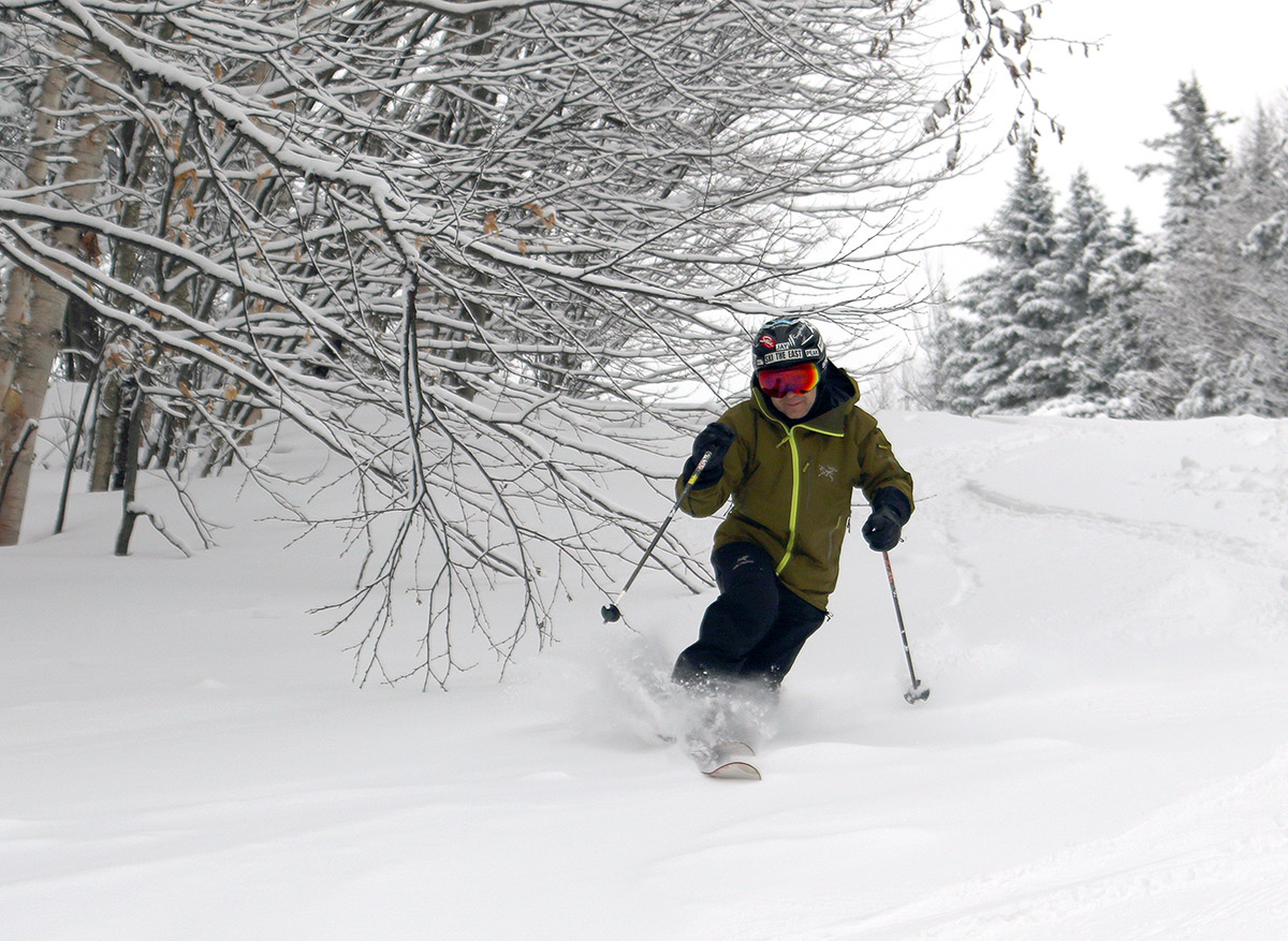
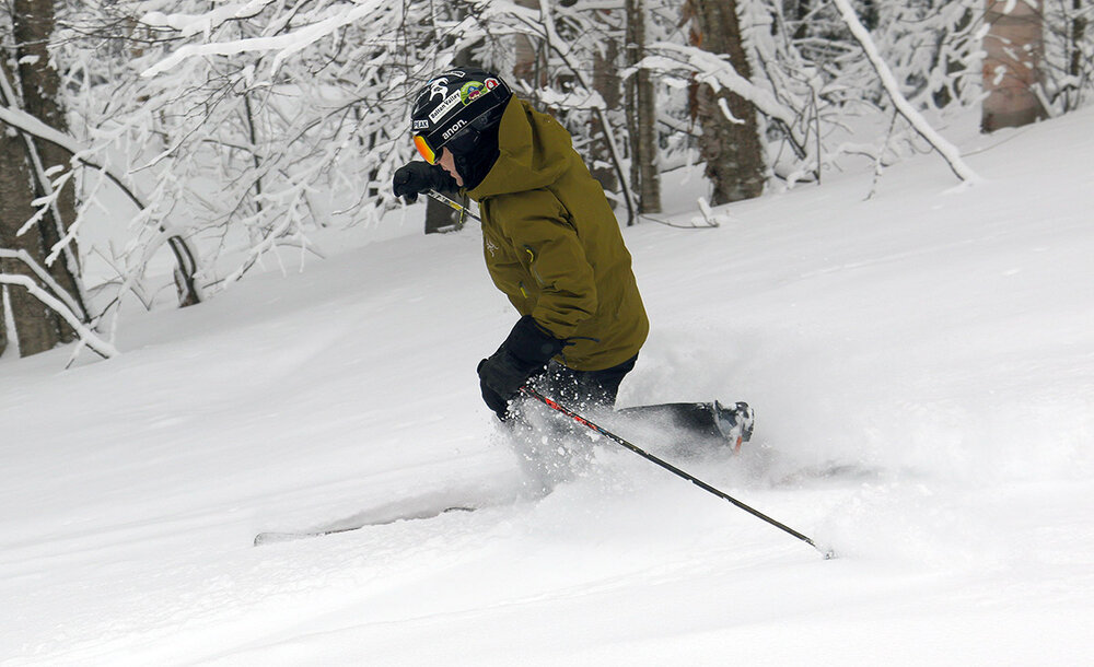
Thanks to some of our recent snows, the conditions I encountered on yesterday’s ski tour at Bolton Valley were certainly decent above 2,000’ and getting quite good above 2,500’. With some additional snow overnight, and temperatures expected to reach up into the 20s F today, it was enough to get me thinking about heading out again. My wife also had some time to ski, so the two of us headed up to Bolton for a morning session. With all lifts running, we were able to park down at Timberline, but based on the elevation dependence I’d seen in the snow accumulations and quality, we headed right up to the main mountain for most of our skiing. The additional of some new overnight snow helped all around, but there were still dramatic differences with respect to the quality of conditions at various elevations. I hadn’t gotten up above 3,000’ yesterday, but I did today, and the depths of the surface snow were impressive. I was finding 12-15” of powder in undisturbed areas at the top of Wilderness, so there really are some impressive areas of good skiing once you get up at to those elevations. We didn’t do much skiing in the lower elevation terrain of Timberline until we were heading back to the car, but skiing off piste down near the 1,500’ elevations range made it clear that it wasn’t worth spending a lot of time down there. Even in untouched areas on the lower slopes of Spell Binder there were just a couple inches of powder above the hard subsurface, so there’s no real chance of getting any sort of bottomless turns, even on lower angle terrain.


-
Precip "free"? I'm assuming that was a typo, lol
-

January 18th Back Door NW Trend Snow OBS Thread
LVblizzard replied to Mikeymac5306's topic in Philadelphia Region
Snow starting in central PA, a bit ahead of schedule. Expecting around 2” from this in Allentown…hopefully the evening stuff comes west for a little more. -
-

Central PA Winter 25/26 Discussion and Obs
MAG5035 replied to MAG5035's topic in Upstate New York/Pennsylvania
Pretty solid area of snow has blossomed up from WV over western and central PA the last couple hours. Something that the HRRR hasn’t really seen at all in recent runs where it doesn’t blossom precip til later over the Sus Valley. 0z 3k NAM looks to have seen that better as have the RGEM and globals. So I guess in other words, the HRRR is about the only thing that didn’t see that. Snow falling here isn’t doing much currently, but it is accumulating up in the Laurels per 511 cams. -
Ecmwf almost gets the entire country precip free on friday.
-
Not only is it damn hard for Mid Atlantic to get snow, but we can't even get that damn reaper to get up off of the damn couch, get that jelly donut out of his demonic face, and put on that murder garment and come reap us up because it hasnt even snowed in YEARS here in the Mid Atlantic! And we are ALL on the LEDGE!
-

Storm potential January 17th-18th
WeatherGeek2025 replied to WeatherGeek2025's topic in New York City Metro
pax i long time no speak, i think you're going to be in the bullseyes, you could get 7 inches tomorrow - Today
-
First Legit Storm Potential of the Season Upon Us
40/70 Benchmark replied to 40/70 Benchmark's topic in New England
3.25"