All Activity
- Past hour
-
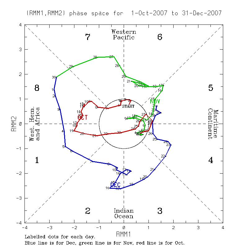
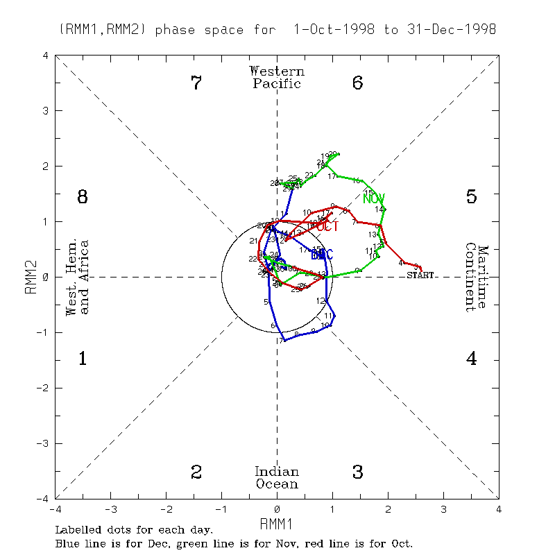
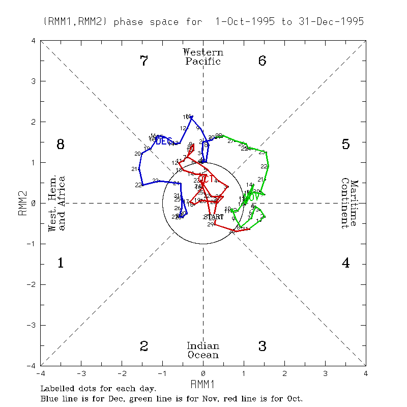
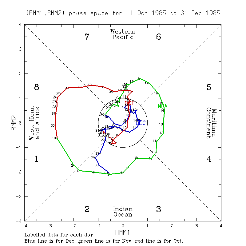
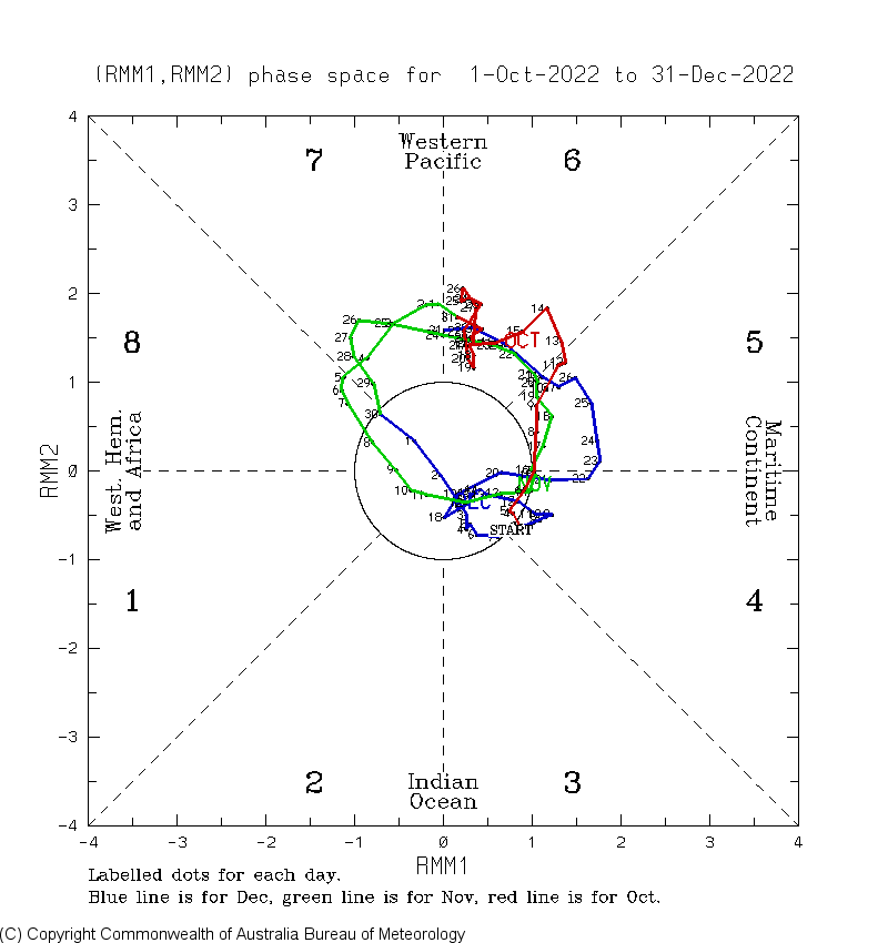
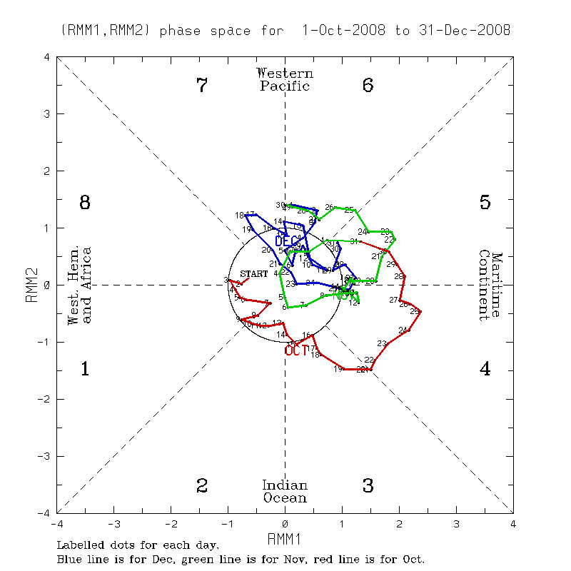
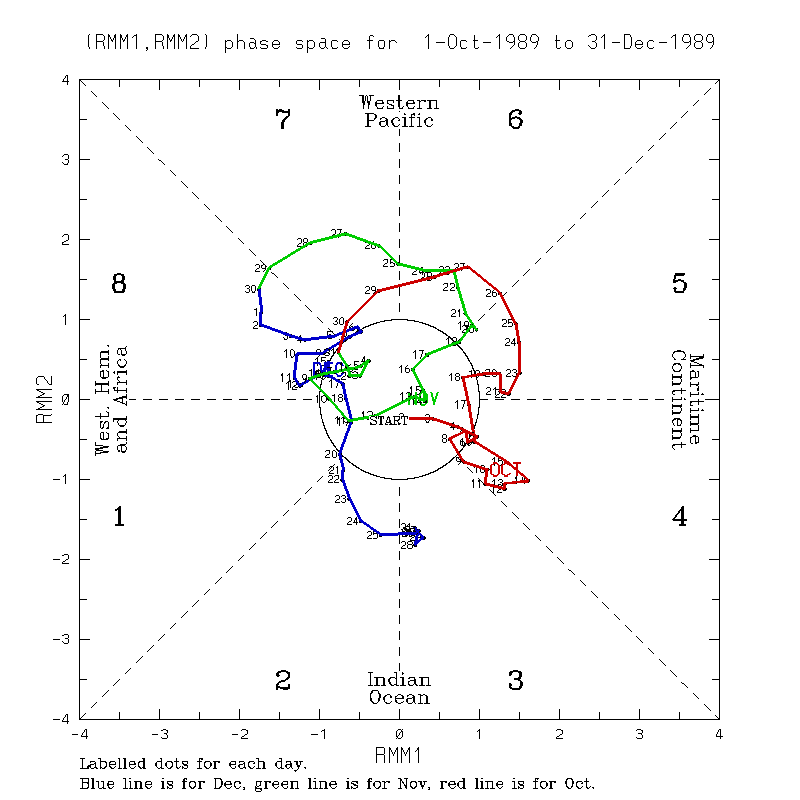
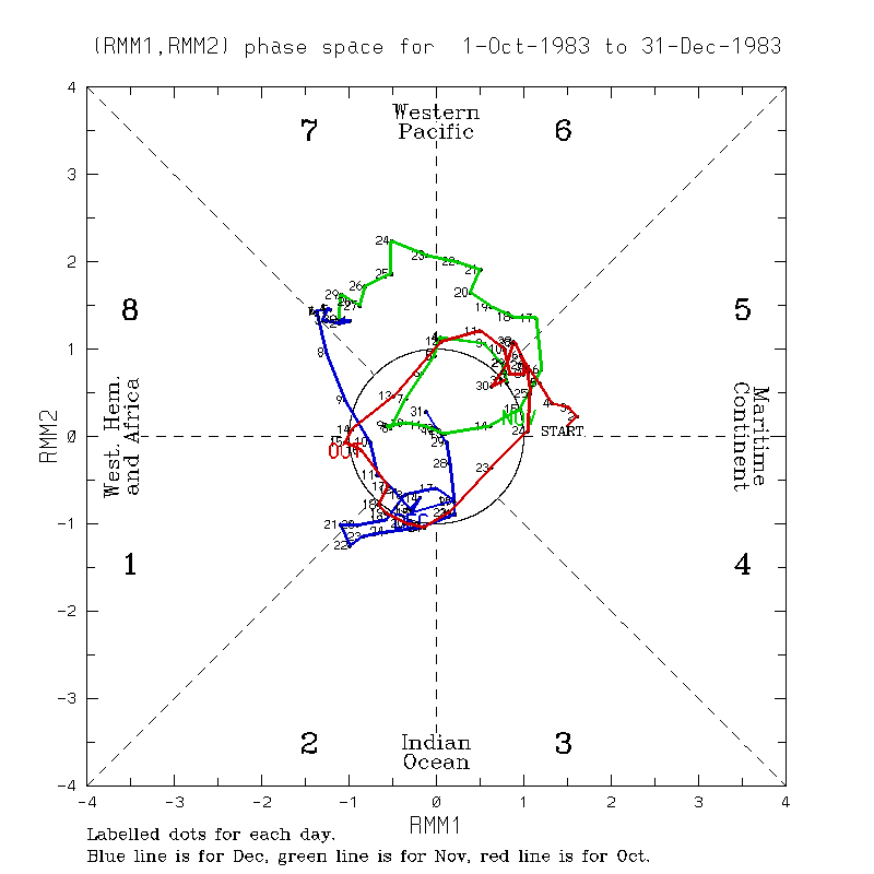
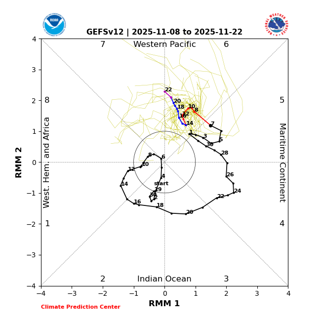
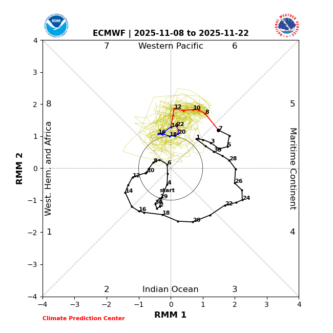
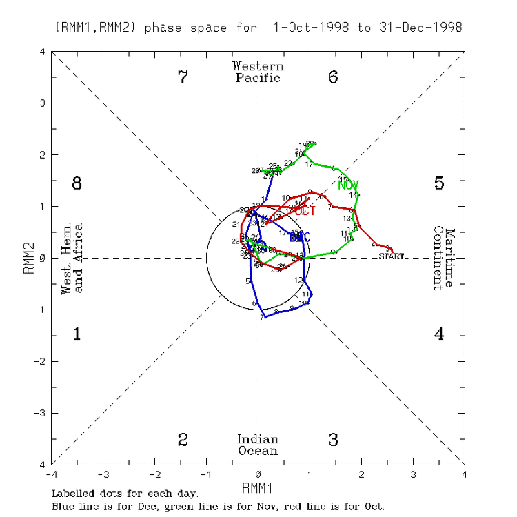
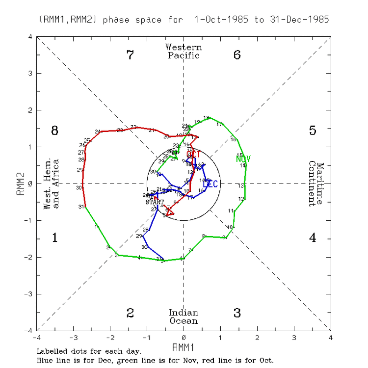
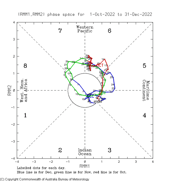
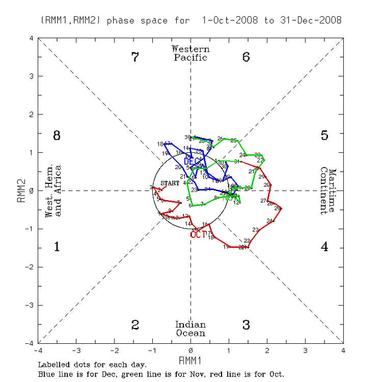
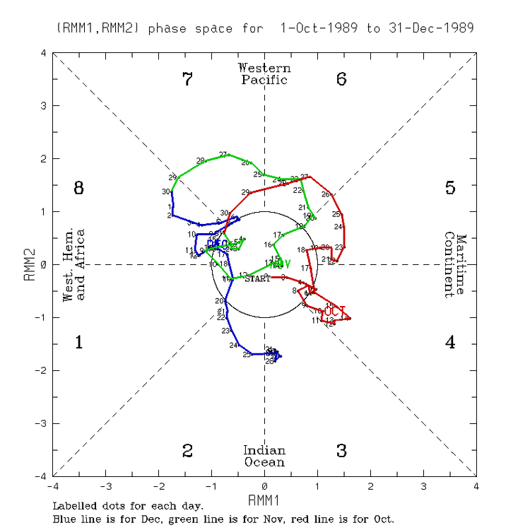
Here’s today’s GEFS MJO forecast: EPS: ——————- Here are the 4 closest Niña Nov MJO analogs: 2007: 1998: 1995: 1985: —————— Now here are the 4 honorable mentions: 2022: 2008: 1989: 1983: @snowman19


-
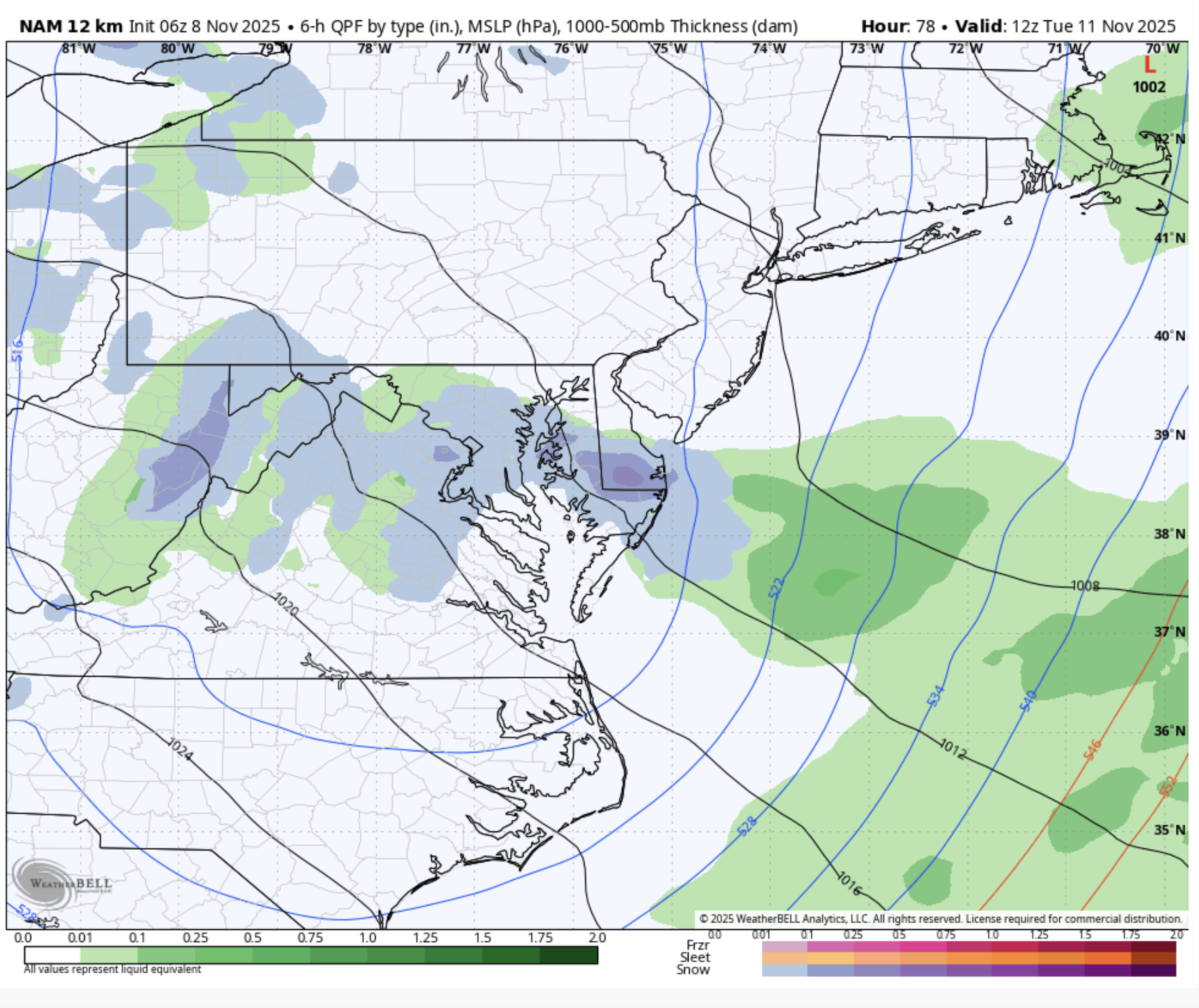
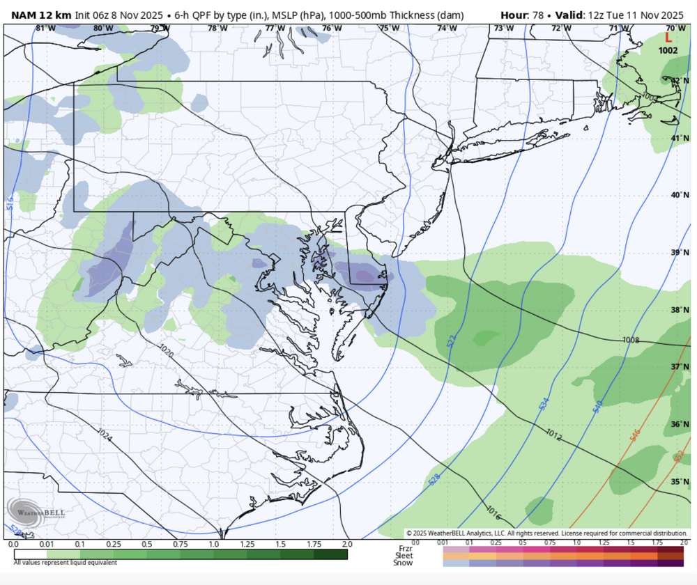
ALL HAIL THE NAM (we're almost in NAM 3km range now)
-
57 here
-
 Aside from the snow part, what else did I say that was wrong? Lol As for the snow, I guess my main issue with that part is that New England isn't as consistently cold in the winter like it used to be and like the Midwest still is. I don't think anybody can deny that fact. I'm not saying that every month has to be February 2015 but still. When it comes to blizzards I have more of a wind fetish than snow I guess. I'd be more interested in the Midwest blizzards with 3-4 inches of snow with 70-80 mph winds than our 1-2 feet with 40-50 mph winds. At least their 4 inches of snow will last all winter because it stays cold whereas our foot of snow will be gone the next week. Idk
 -
That’s very interesting. I didn’t specifically recall those two snowstorms, so I went to my data, and I can see why – they were definitely not the 2 biggest snowstorms of the season over here at our site. They were both fairly small, and well down in the hierarchy of the 61 storms on the season – they weren’t part of the top 10, and they didn’t even make the top 20. The 11/28-29 snowstorm (potent low pressure tracking across southern New England) brought 2.3 inches of snow and ranked 29th, and the 12/4-5 snowstorm (Clipper system racing eastward from southwestern Quebec to northern Maine) brought 2.9 inches of snow and ranked 23rd. It’s always amazing how two NNE sites at similar latitudes can have such different winter regimes. The largest snowstorms of the season over here were in January and February, and in terms of the 24-25 winter as a whole, most skiers/mountain recreation types in this area would probably take a repeat if push came to shove. It wasn’t a perfect winter, with a fairly weak November in the lower elevations and a relatively slow period leading into the first half of December and again near the holidays, but with all the local ski resorts in the Northern Greens ultimately recording 350”+ of snow and Jay Peak hitting 475”, combined with a very stable period in midwinter without any huge rainstorms, it was a solid performer.
-
So the Euro and GFS have switched solutions such that the GFS gives us snow and the Euro doesn't because it goes to NC, but overall its the same look--gfs caves to the euro
-
 Take these as long as we can.
 -

November 2025 general discussions and probable topic derailings ...
WinterWolf replied to Typhoon Tip's topic in New England
Maybe you missed what was asked..let’s keep it to weather. Take your crap to the proper thread. -
This was Nov 18 - 23 1953 - Residents of New York City suffered through ten days of smog resulting in 200 deaths. (The Weather Channel) In November 1953, a stagnant air mass settled over New York City from roughly November 18 to 23, trapping pollutants close to the ground and creating a dense smog that blanketed the city for nearly a week. Heavy use of coal-fired heating, industrial furnaces, incinerators, and vehicle exhaust filled the air with sulfur dioxide and soot that could not disperse due to the atmospheric inversion. As a result, air-pollution levels surged to dangerous concentrations, leading to a sharp increase in respiratory and cardiac illnesses. Health officials later estimated that between 170 and 260 excess deaths occurred during the event. The disaster became a turning point in U.S. urban air-quality awareness, helping to spur stronger local and national pollution-control measures in the years that followed.
-

November 2025 general discussions and probable topic derailings ...
IrishRob17 replied to Typhoon Tip's topic in New England
In my case I was born and lived in New Hampshire as a young child, love keeping tabs on New England weather, especially northern New England. When I retire there's a decent chance I'll become a local again. -
0.34” overnight in my corner of Columbia.
-
November 2025 general discussions and probable topic derailings ...
WinterWolf replied to Typhoon Tip's topic in New England
Bro, almost everything you said there is wrong. Lol. But whatever. Just so you know, Midwest and plains get less snow than most of New England. -
Through the first week of Nov Dep (rain) EWR: +1.8 (0.09) NYC: +1.1 (0.21) LGA: +0.9 (0.11) JFK: + 0.7 (0.01)
-
Chill pushing into the upper midwest
-
Maybe a couple hundredths. Fine with me as I have a ton of leaves to blow. Nice and dry..
-
A quick note: Denver finally surpassed its monthly record that was set in 2006 this year. On November 2, the mercury topped out at 83° in Denver.
-

November 2025 general discussions and probable topic derailings ...
CoastalWx replied to Typhoon Tip's topic in New England
Yeah he’s gone. Sure we had some duds but we’ve had some decent events too. -
 0.13" overnight, up to 48.5F and still cloudy. Pond is still down about 4ft, lowest water level yet for this time of year, even drier than 2016 summer/autumn, it's always been full by the time it freezes up in late Nov. Oak, beech, apple and birch leaves still hanging tough despite the many strong gusts over the past week.
 -
Highs: EWR: 77 (2020) NYC: 76 (1975) LGA: 77 (2020) JFK: 74 (2020) Lows: EWR: 27 (1976) NYC: 29 (2019) LGA: 31 (2019) JFK: 28 (1976) Historical: 1870 - The first storm warning was issued by the U.S. Signal Corps Weather Service. (Sandra and TI Richard Sanders - 1987) 1870: The U.S. Signal Corps Weather Service issued the first storm warning on this day. Professor Increase A. Lapham believed that warnings of deadly storms on the Great Lakes could be derived from telegraphed weather observations. As a result, a bill was introduced and signed into law to establish a national telegraphic weather service. The Signal Corps began taking observations of November 1st, 1870. On this date, Lapham would issue the first storm warning, a cautionary forecast for the Great Lakes. 1879: A tornado struck Crawford County, Arkansas, killing several people. 1913: The Great Lakes Storm of November 7-13, 1913, was a blizzard with hurricane-force winds that devastated the Great Lakes Region, sinking as many as 19 ships and stranding 19 others. This storm would be the deadliest and most destructive natural disaster ever to hit the Great Lakes. 1914: It finally rained on this date in Bagdad, California, breaking an incredible rain-free streak of 767 days, the U.S. record! (Ref. AccWeather Weather History) 1943: 3.20 inches of rain fell in 24 hrs. at WBO in Washington, DC. (Washington Weather Records - KDCA) 1943 - An early season snowstorm raged across eastern South Dakota and Minnesota into northern Wisconsin. The storm produced 22 inches of snow at Fairbult and Marshall MN, 20 inches at Redwood Falls MN, and 10.1 inches at Minneapolis. Drifts fifteen feet high were reported in Cottonwood County MN. The storm produced up to two feet of snow in South Dakota smothering a million Thanksgiving day turkeys. (6th-8th) (David Ludlum) (The Weather Channel) 1966 - The temperature in downtown San Francisco reached a November record of 86 degrees. (The Weather Channel) 1987 - Thunderstorms over Texas produced locally heavy rains in the Hill Country, with 3.50 inches reported at Lakeway, and 3.72 inches reported at Anderson Mill. Thunderstorms over Louisiana produced hail an inch in diameter at Clay and at Provencial. Blustery northwest winds, ushering cold air into western Kansas and into northwest Texas, gusted to 46 mph at Hill City KS. (Storm Data) (The National Weather Summary) 1988 - Fair weather prevailed across much of the nation for Election Day. Midland TX equalled their record for November with an afternoon high of 89 degrees, and the record high of 87 degrees at Roswell NM was their fifth in eight days. (Storm Data) (The National Weather Summary) 1989 - Afternoon and evening thunderstorms developing along and ahead of a cold front produced severe weather from northern Louisiana into central Georgia. Thunderstorms spawned three tornadoes, and there were sixty-four reports of large hail or damaging winds. A late afternoon thunderstorm in central Georgia spawned a tornado which killed one person and injured eight others at Pineview. Late afternoon thunderstorms in central Mississippi produced baseball size hail around Jackson, and wind gusts to 70 mph Walnut Grove. (The National Weather Summary) (Storm Data) 1991: The first week in November in Iowa was extremely cold. The average temperature over the state for the week was 18.3°, which is 24.7 degrees below normal. This was easily the coldest first week of November in 100 years of record. (Ref. AccWeather Weather History) 1994: The twelfth and final tropical cyclone of the Atlantic hurricane season formed in the southwestern Caribbean. While Hurricane Gordon was only a Category 1, it killed 1,149 individuals, including 1,122 in Haiti. 1999: Kennebec, South Dakota: The temperature reaches 89 °F, breaking the all time record for the warmest November maximum temperature ever recorded in the state. (Ref. WxDoctor) 85 record high temperatures fell across the Midwest as Indian Summer weather was felt across the region. Many locations set new high temperature records for the month of November, not just for the date, including Valetine NE, where the mercury topped out at 86 degrees. Other records included 82 in Omaha NE and 86 in Huron SD. Pierre SD was the nation's hot spot, with a high of 87 degrees that was a record for November. For the second day in a row, Winner SD set a new November record. (Ref. AccWeather Weather History) 2006: Denver, CO climbed to 80°. their highest November temperature since records began in 1872 and the highest temperature for so late in the season. Chadron, NE also hit 80°, their latest 80 degree reading for so late in the season. (Ref. Wilson Weather History)
-
Did you read IWX this morning? Given the incredible thermodynamics, Lake Superior connection, and synoptic support any mesolow or dominant band will be capable of producing snowfall rates of up to 3"/hour with thundersnow quite possible. There is still some uncertainty where exactly the band sets up and how long it stays in one area (models show some variation to the flow through Monday), but snow will be measured in feet, not inches, for any location that sees this dominant band visit for more than a few hours. Have a conservative 6-12" for La Porte County right now but that could certainly go higher. Winds will also be a concern with this event.
-

November 2025 general discussions and probable topic derailings ...
Ginx snewx replied to Typhoon Tip's topic in New England
Rain can go away too much to do outside to prepare for a classic New England winter. Love the snow capped look up north already. Its coming -
 It has been boring recently, but we will get our share of violent weather soon
 -

November 2025 general discussions and probable topic derailings ...
wx2fish replied to Typhoon Tip's topic in New England
Selling our winters a little short. Been a run of duds, but New England wins for annual snow per elevation in the Conus. Aside from the immediate lake effect zones, the Plains and Midwest get less than alot of New England -
November 2025 general discussions and probable topic derailings ...
Ginx snewx replied to Typhoon Tip's topic in New England
Well I don't know if that's all true. We certainly have had our share of violent storms and severe winters. Recency bias.