All Activity
- Past hour
-
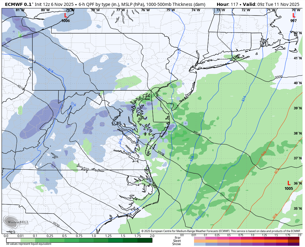
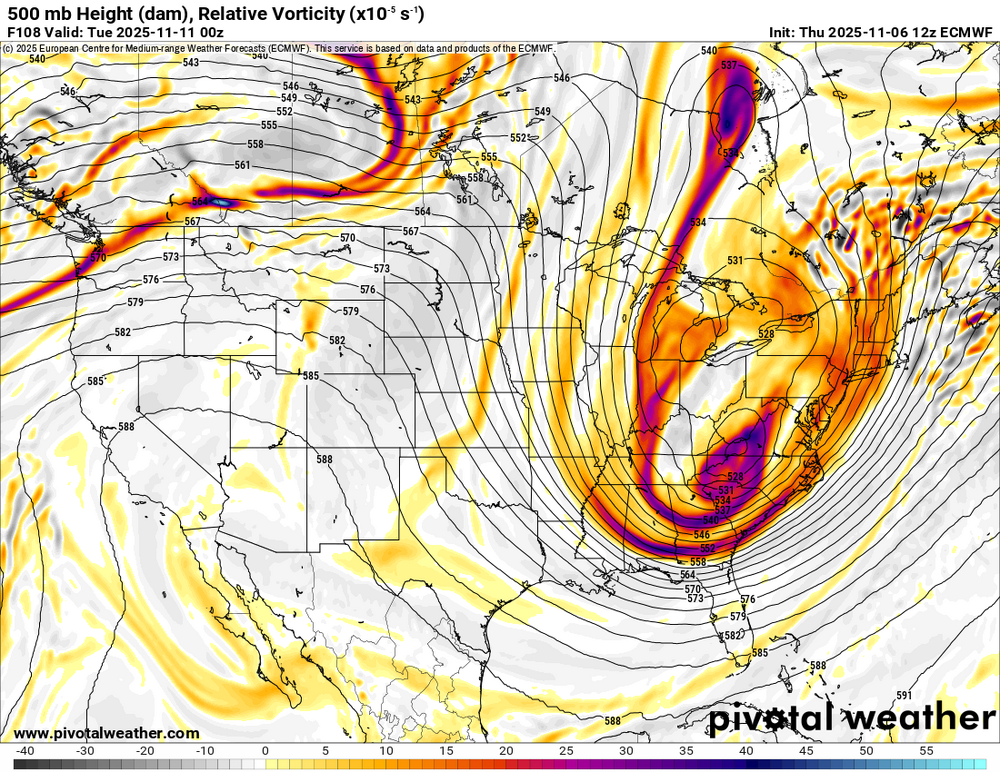
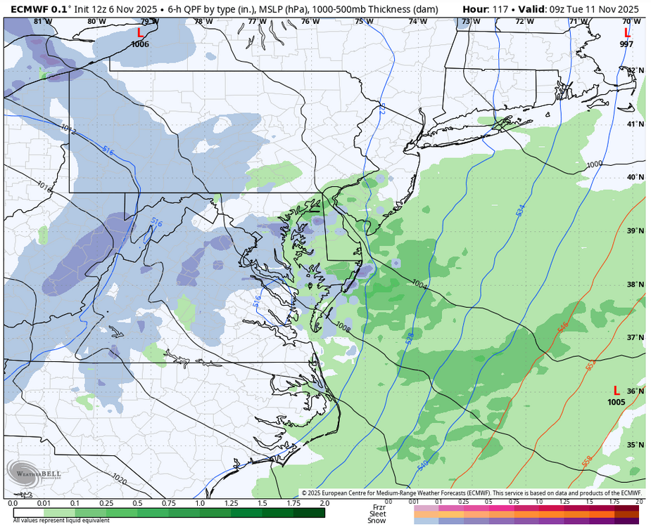
The Euro is interesting in that it is digging a potent 500 low which provides the dynamics needed for a post-frontal burst of precip. The GFS does not have this (nor does the AIFS for that matter). Probably a pipe dream, but worth keeping an eye on.
-
We know there have been some memorable snow chases at the beach, specifically Bethany and Rehoboth during previous winters such as this one coming up featuring Nina background state. This forecast has that area in 0 to 6 in. Will be interesting to reflect back on this forecast must we get to early March.
-

November 2025 general discussions and probable topic derailings ...
dryslot replied to Typhoon Tip's topic in New England
Looks like a gust of 39 mph at the house today, Winds always seem to under perform unless it involves convection. -
The 12z RGEM now has the system in range and has healthy bands of snow, rain/snow mix, and rain showers over the eastern half of the forum area - just like the Euro has had run-after-run for days. I am honestly surprised to see the Euro hold after missing so much last season and it being shoulder season.
-
Every pattern is different . You can think otherwise .
-
Gradient/SWFE patterns are a dream for your area and when things are right be okay here but definitely not what I’d prefer. South of Philly gets shut out in that type of pattern. Like I said-we can’t do anything about the laws of physics or reality. Without benchmark nor’easters that’s pretty much what MBY is stuck with when we can’t get 3-5” type clippers the way we used to. Selfishly I hope the NNE drought continues.
-
The Euro maintains it's basic camp for our region, the GFS does as well.
-
Shades of November 2018....
-
The 12z CMC now brings the backside energy in the form of heavy snow showers on NW flow...complete cave by it.
-

November 2025 general discussions and probable topic derailings ...
weathafella replied to Typhoon Tip's topic in New England
Yeah the wind advisory was a bit of a bust here though it gusted overnight for a short time as the front blew through. We continue to step. -
Pretty interesting development on the 12z GFS and a fair amount of change. It pops a low over the Piedmont of North Carolina as opposed the northern stream dominate solutions it previously had. If true, the Euro(if it doesn't flip at 12z) has score a "1 vs everybody" coup.
-
November 2025 general discussions and probable topic derailings ...
dryslot replied to Typhoon Tip's topic in New England
Have to check the stratus but it was 0.11" thru the tipper. -
 Breezy is a good way to describe it, it's nothing like the other day.
 -
Oaks here targeting a full leaf drop around mid January .
-
That was a much snowier era due to the numerous benchmark storm tracks in the mix. NYC Metro needs the benchmark track to reach normal snowfall these days. When it was much colder prior to the 1990s, we could count on some seasons reaching average without a big benchmark KU event. Since we had clippers which went to our south without getting suppressed and huggers which had enough cold for a good front end snow before changeover. Your area is positioned better than NYC during changeovers since interior NJ is colder both at the surface and aloft. So you can gain more snow out of a marginal storm track. NYC 1987-2002 average…21.8”……1987-2002….14.9”
-

November 2025 general discussions and probable topic derailings ...
CoastalWx replied to Typhoon Tip's topic in New England
Not by much lol. -
12z Euro likes the idea of more than flurries.

-
I see that text, but I would call that snowfall map average to a bit below average. Looks like a good report though.( I didn't read the whole thing, I confess)
-

2025-2026 ENSO
40/70 Benchmark replied to 40/70 Benchmark's topic in Weather Forecasting and Discussion
I'm confident that isn't permanent. SE Canada is going to get colder, as we saw last year and are likely about to again. That helps the NE more than the mid atl, but it is what it is. -

November 2025 general discussions and probable topic derailings ...
Ginx snewx replied to Typhoon Tip's topic in New England
Windsexy -
 Actually managed a few real flakes for about 10 seconds.
 -
From 2000-18 generally (had our share of crap winters in that stretch too but generally good to great) we had an overall pattern to support more benchmark storm tracks and therefore above normal snow seasons for the NYC metro. NYC is also far enough NE to catch some of the late bloomer Miller Bs that nail Boston/New England. The Pacific was in better shape with periods of +PDO and drove a more favorable pattern. Bluewave pointed it out many times and showed data to back up the assertion that in 2019 that background changed and we essentially entered a never ending Nina-like state in the mid latitudes with a very warm W Pacific which drives a hostile Pacific jet. Back in the 80s/early 90s we also had hostile patterns but back then we could also count on clippers once in a while or decent front end events so at least we weren’t shut out other than outright atrocious winters like 72-73. I’m not sold on this regime being permanent but there’s no doubt in my mind that other than a rabbit out of the hat rare 20-21 type winter (and even that was modestly above average for NYC itself, the best that winter was in N NJ), the Pacific regime needs to change to get this area back in the game for above average snow winters.
-

November 2025 general discussions and probable topic derailings ...
MegaMike replied to Typhoon Tip's topic in New England
Pretty cool looking! Consensus is, that's the exhaust plume from the European Space Agency's Ariane 6 rocket (launched at Kourou, French Guiana). -
2025-2026 ENSO
40/70 Benchmark replied to 40/70 Benchmark's topic in Weather Forecasting and Discussion
It's definitely not zero....but I don't view this as a season that screams "KU". -
Yall. We aren’t doing that here. Send each other PMs, or emails off board.