All Activity
- Past hour
-
I’m planning to go leaf chasing/hiking to spruce knob wv tomorrow, anyone know how the colors are out there?
-
39.2, first 30s! For real, 1st 40s? I know our locations differ, but I've had probably 8-10 40s already, and low 40s a few times. That is wild since you aren't really in a city. Tony was 55 lol.
-
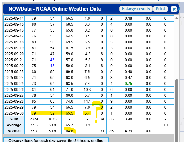
Using 9/30 as an example...If normal for Sept is 64.8, and 9/30 average temp was 65.5, how does that = 6.4 AN? this is data for Hartford if it matters
-
Eastern one now a pumpkin.
-
Statistically pretty unlikely since the warm spots like Newark haven’t stayed under 70° from 10-8 to 10-18 which is the end of the GFS run since 2002. Time Series Summary for NEWARK LIBERTY INTL AP, NJ max temp 10-8 to 10-18 Click column heading to sort ascending, click again to sort descending. 2024-10-18 78 0 2023-10-18 74 0 2022-10-18 71 0 2021-10-18 84 0 2020-10-18 77 0 2019-10-18 75 0 2018-10-18 81 0 2017-10-18 83 0 2016-10-18 85 0 2015-10-18 81 0 2014-10-18 79 0 2013-10-18 75 0 2012-10-18 73 0 2011-10-18 88 0 2010-10-18 79 0 2009-10-18 73 0 2008-10-18 79 0 2007-10-18 89 0 2006-10-18 80 0 2005-10-18 75 0 2004-10-18 76 0 2003-10-18 78 0 2002-10-18 65 0
-
38.1 for the low this morning. Very misty. The temp rose for several hours after midnight, otherwise we would have had our first frost.
-

Central PA Fall Discussions and Obs
Mount Joy Snowman replied to ChescoWx's topic in Upstate New York/Pennsylvania
Low of 46. Beautiful days. -

Spooky Season (October Disco Thread)
Damage In Tolland replied to Prismshine Productions's topic in New England
Looks dry and benign right thru end of month -
much different than the Euro which surges more warmth into the east coast 10/10 - beyond with a strong ridge into MS valley. Maybe a middle ground near / above normal is a good compromise at this point.
-
6Z GFS says the last day over 70 is this Tuesday for the duration of the run.
-

Central PA Fall Discussions and Obs
canderson replied to ChescoWx's topic in Upstate New York/Pennsylvania
We are going be close to 15 degrees above normal highs this weekend. -
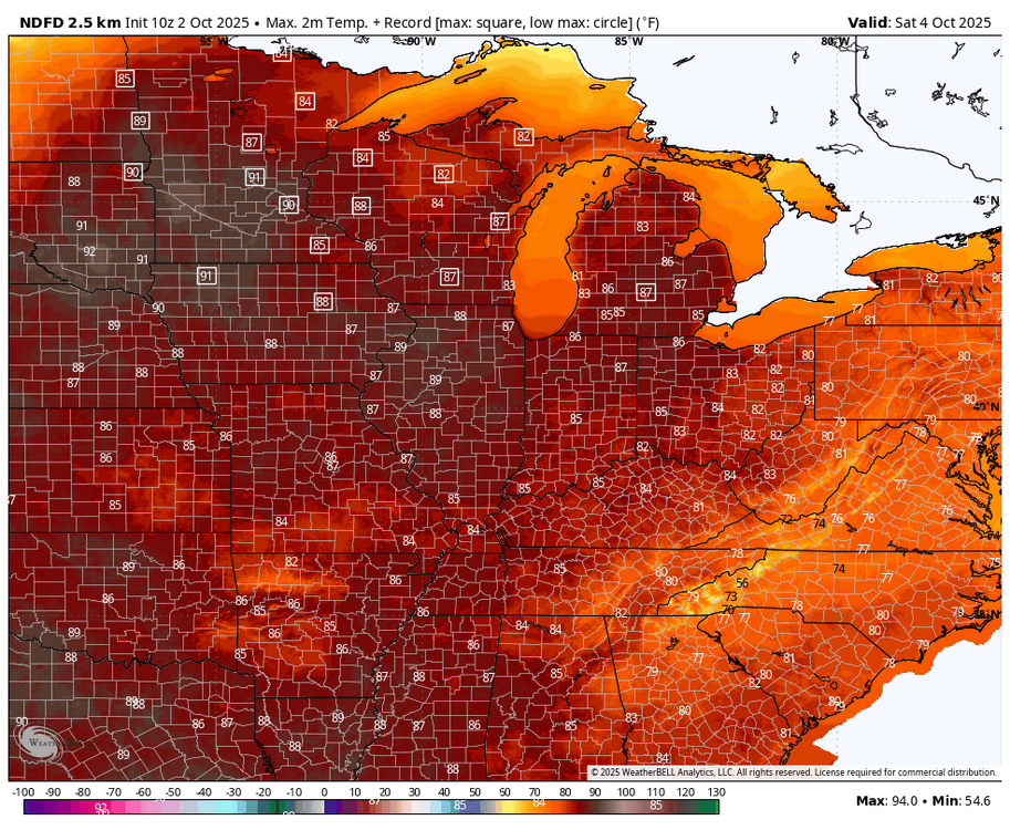
Another over the top warm up this weekend with the record 90° heat forecast for MSP while we stay in the 80s.

-
Right, I don't either, I consider an inch or more a good dousing. I kind of overstated due to enthusiasm and all the dryness this past summer.
-

2025 Atlantic Hurricane Season
olafminesaw replied to BarryStantonGBP's topic in Tropical Headquarters
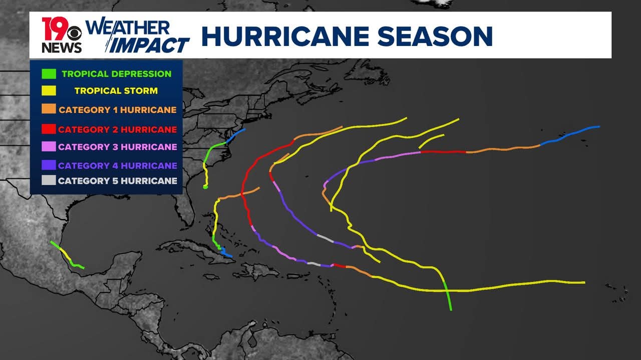
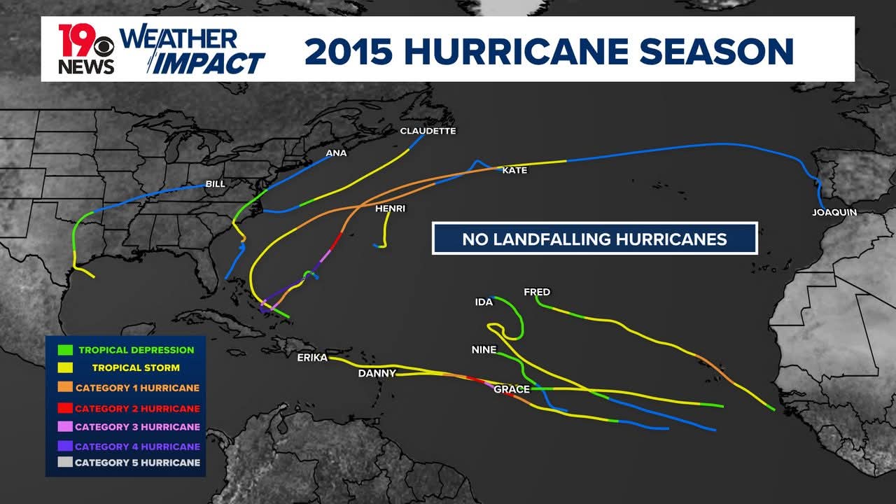
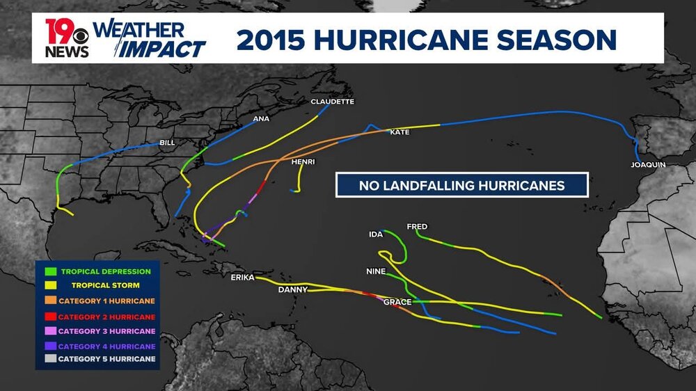
Pretty crazy how closely 2015 matches to this season
-

Spooky Season (October Disco Thread)
CoastalWx replied to Prismshine Productions's topic in New England
Even last night was only 45. By the time I left the house at 5:50 there was already a breeze and temp rising. -
(002).thumb.png.6e3d9d46bca5fe41aab7a74871dd8af8.png)
Central PA Fall Discussions and Obs
ChescoWx replied to ChescoWx's topic in Upstate New York/Pennsylvania
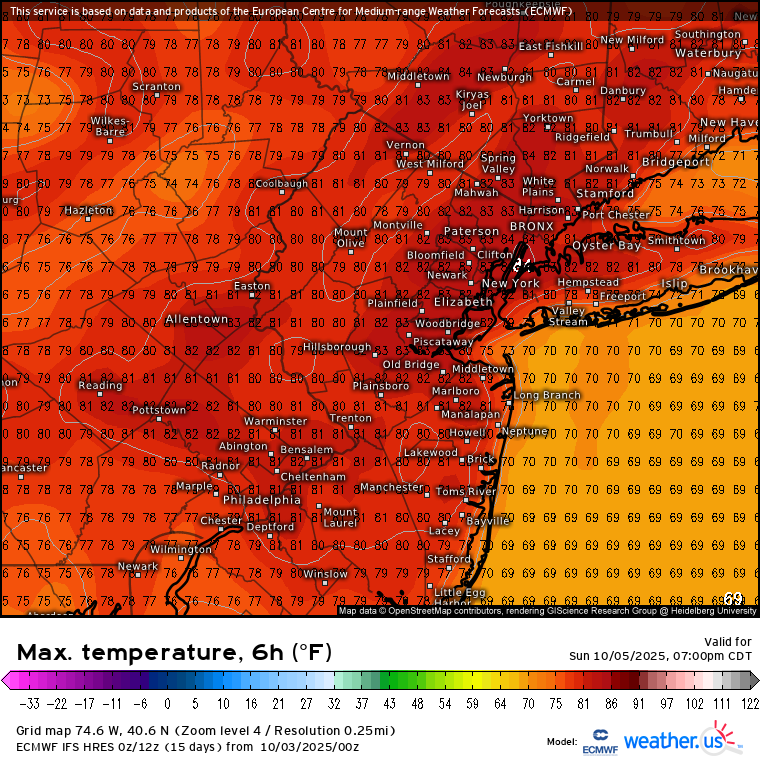
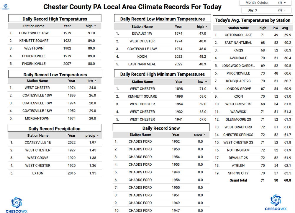
Some of our colder valley locations again saw low temperatures this morning in the upper 30's with most other spots remaining in the lower 40's. A beautiful stretch of weather through Tuesday with temperatures near normal for early October today with highs in the upper 60's to near 70 degrees. We warm up to above normal tomorrow through Tuesday. Shower chances arrive on Tuesday night with a cold front which will turn us sharply cooler again by later next week.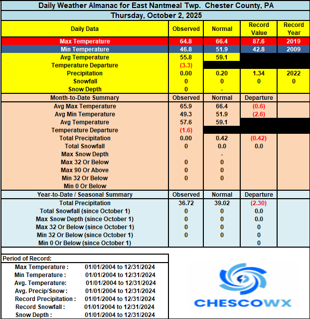
-
Spooky Season (October Disco Thread)
CoastalWx replied to Prismshine Productions's topic in New England
Yeah I don’t consider .25” a good dousing. I guess it’s subjective. -
E PA/NJ/DE Autumn 2025 Obs/Discussion
ChescoWx replied to PhiEaglesfan712's topic in Philadelphia Region
Some of our colder valley locations again saw low temperatures this morning in the upper 30's with most other spots remaining in the lower 40's. A beautiful stretch of weather through Tuesday with temperatures near normal for early October today with highs in the upper 60's to near 70 degrees. We warm up to above normal tomorrow through Tuesday. Shower chances arrive on Tuesday night with a cold front which will turn us sharply cooler again by later next week.
-

Central PA Fall Discussions and Obs
Superstorm replied to ChescoWx's topic in Upstate New York/Pennsylvania
Just to put in perspective, it was 46F for a low on August 30th. Not very impressive for October 3rd. -
Records: Highs: EWR: 85 (2023) NYC: 87 (1919) LGA: 85 (2000) JFK: 84 (2002) Lows: EWR: 37 (1945) NYC: 38 (1974) LGA: 40 (1974) JFK: 40 (2003) Historical: 1780: A hurricane, which formed on October 1st, destroyed the port city of Savanna-la-Mar on the island of Jamaica on this day. By some estimates, this stormed caused 3,000 deaths. This storm is documented in the Jamaica Archives and Record Department. 1780: The hurricane season of 1780 was one of the worst in recorded history. At least 8 destructive storms struck American and Caribbean shores that year. In October, three storms in three successive weeks caused unparalleled economic and military destruction. The first, named the Savanna-La-Mer hurricane for the tiny settlement on the island of Jamaica which was completely destroyed by the storm's tides and winds, struck on this date. (Ref. AccWeather Weather History) 1841 - An October gale, the worst of record for Nantucket, MA, caught the Cap Cod fishing fleet at sea. Forty ships were driven ashore on Cape Cod, and 57 men perished from the town of Truro alone. Heavy snow fell inland, with 18 inches near Middletown, CT. (David Ludlum) 1903: An unusual late-season tornado moved northeast from west of Chatfield, Minnesota, passing through and devastating St. Charles, Minnesota. Seven people were killed, and 30 injured as 50 homes and businesses were damaged or destroyed. 1912 - The longest dry spell of record in the U.S. commenced as Bagdad, CA, went 767 days without rain. (David Ludlum) 1963: Hurricane Flora, one of the deadliest hurricanes on record in the Atlantic Basin, battered Haiti with sustained winds around 150 mph. The storm moved northwestward, meandered over western Cuba from the 4th to the 8th, and then finally accelerated northeastward out to sea. 5,000 people were killed on Haiti with damage severe to complete. Enormous amounts of rain fell in Cuba due to Flora's slow movement. 90 inches of rain deluged Bayamo. A total of 7,200 people were killed by Flora and damage was set at $435 million dollars. (Ref. Wilson Wx. History) 1964 - Hurricane Hilda struck Louisiana spawning many tornadoes, and claimed twenty-two lives. (Sandra and TI Richard Sanders) 1966: Late on this date Hurricane Inez began moving southwestward from a position about 100 miles east of Miami, FL. The eye of Inez moved from Key Largo to Key West on the 4th. The highest wind reported on the Florida mainland was a gust to 80 mph at Homestead AFB. All of the Keys reported winds of hurricane force ranging up to 100-125 mph in gusts. Three people were killed and 11 more were injured. Over $5 million dollars in damage resulted. (Ref. Wilson Wx. History) 1970: The National Oceanic & Atmospheric Administration was formed and the U.S. Weather Bureau became the National Weather Service. (Ref. Wilson Wx. History) 1974: Richmond, Virginia had its earliest first freezing day of autumn on this date in 1974 when the temperature fell to 31 °F. (Ref. Richmond Weather Records) 1979 - The first killer tornado of record in October in Connecticut destroyed sixteen vintage aircraft at the Bradley Air Museum in Windsor Locks. The tornado damaged more than one hundred homes causing 200 million dollars damage. Three persons were killed, and 500 others were injured. (The Weather Channel) 1979: An F4 tornado struck the towns of Windsor, Windsor Locks, and Suffield in Connecticut, causing an estimated $400 million in property damage, on this day. The New England Air Museum, which housed more than 20 vintage aircraft, was destroyed. This tornado also caused a United Airlines flight to abort a landing at the Bradley International Airport because the pilot saw the tornado. 1983: A prolonged very heavy rain event, starting back on September 29th, finally came to an end over the eastern two-thirds of Arizona as rainfall totals ranged from 2 to 12 inches courtesy of moisture from the remains of Tropical Storm Octave. The result was the most destructive flooding ever in Arizona. 13 people were killed and 1,300 homes were destroyed. Damage was estimated at $178 million dollars. (Ref. AccWeather Weather History) 1986 - Remnants of Hurricane Paine deluged Oklahoma and southeastern Kansas with 6 to 10 inch overnight rains. Hardy, OK, was drenched with 21.79 inches. Heavy rain between September 26th and October 4th caused 350 million dollars damage in Oklahoma. (The Weather Channel) 1987 - Twenty-five cities in the Upper Midwest, including ten in Iowa, reported record low temperatures for the date. Duluth MN, Eau Claire, WI, and Spencer, IA, dipped to 24 degrees. Temperatures warmed into the 80s in the Northern and Central High Plains Region. At Chadron, NE, the mercury soared from a morning low of 29 degrees to an afternoon high of 88 degrees. Temperatures soared above 100 degrees in southern California. The high of 108 degrees at Downtown Los Angeles was a record for October. (The National Weather Summary) 1988 - Cold Canadian air invaded the north central U.S. bringing an end to the growing season across those states. Unseasonably warm weather prevailed in the southwestern U.S. Phoenix, AZ, reported a record high of 105 degrees. (The National Weather Summary) 1989 - Unseasonably cold weather prevailed from the Pacific Northwest to the Upper Mississippi Valley. A dozen cities reported record low temperatures for the date, including Bismarck, ND, and Williston, ND, with readings of 16 degrees above zero. An upper level weather disturbance brought snow to parts of Idaho, Wyoming and Montana, with five inches reported at West Yellowstone, MT. (Storm Data) (The National Weather Summary) 1992: A strong tropical disturbance in the eastern Gulf of Mexico spawned 10 tornadoes from the Tampa Bay area to Ocala, killing four people and injuring 77 others. Hardest hit was Pinellas County where all the deaths occurred. Heavy rain caused moderate to heavy flooding in northeast Florida, especially the Jacksonville area where 8.69 inches fell. Brunswick, GA was deluged with 10.14 inches in 24 hours. Major beach erosion occurred at Egmont Key and all along the coast of Hillsborough County. Total damage was estimated at $32 million dollars. (Ref. Wilson Wx. History) 1999: Elkader, IA recorded their earliest measurable snowfall with a half an inch. Embarrass had a low temperature of 9 °F. (Ref. Wilson Wx. History) (Ref. AccWeather Weather History) 2000: Thunderstorms can still be a hazard in the fall season in CO’s Rocky Mts. two people were hurt when hit by lightning while at the Forest Canyon Overlook (approx. 12,000 feet elevation) on Trail Ridge Road. The thunderstorm gave little warning because it formed above them. (Ref. Weather Guide Calendar with Phenomenal Weather Events 2011 Accord Pub. 2010, USA) 2002: Hurricane Lili made landfall between White Lake and Vermilion Bay, Louisiana as a Category 1 storm. 2006: Illinois: Several cities tie or set new maximum temperature records. Dodge City, KS set their all-time October record high of 98 °F Peoria and Springfield hit 93 °F; Moline and Burlington, 95 °F. (Ref. WxDoctor) 2015: Unprecedented rainfall fell throughout South Carolina from October 1st — 5th, 2015. Storm total amounts greater than 20" were observed in Columbia and Sumter. 2017: The City of Houston had the wettest year on record with 73.51 inches. The previous wettest year was in 1900 when 72.86 inches were measured.
-
48° this morning!
-
Was 43 here when I left my house.
-
Edit - I looked too quickly. Now I see 33 in Keene. We do get a little cooler here with radiational cooling. My last sentence still stands...ha. Huh, was I hallucinating this morning? First, rain chance gets nixed by some party pooper, now low in that graphic says 37F here, when I woke up to 31F (KEEN, closest station). We vary a little (lower elevation on CT Rive, 300 ft. above sea level). More coffee, please, or something stronger?
-
Central PA Fall Discussions and Obs
Superstorm replied to ChescoWx's topic in Upstate New York/Pennsylvania
45F for low in Lancaster. -
44.0 in Muttontown & 45.1 in Syosset.