All Activity
- Past hour
-

September 2025 OBS-Discussion centered NYC subforum
uofmiami replied to wdrag's topic in New York City Metro
Well compared to naked swirl aka Gabrielle, maybe he has a point, haha I don't get how Gabrielle exists at the moment. -
Yeah the winter pattern is set. The warm blob's gonna go away, the western pac will boil. We'll get a horrible zonal pac jet that floods the east with warm mild air, and the rockies and west will get freezing cold and snowstorms every day. 22-23 / 23-24 repeat, but possibly worse.
-

September 2025 OBS-Discussion centered NYC subforum
STORMANLI replied to wdrag's topic in New York City Metro
Well said. Cold-core low. That alone should dispel any argument. -
Lol yeah the pattern in recent years has been the total opposite in fact. Cold out west, blowtorch in the east.
-

September 2025 OBS-Discussion centered NYC subforum
donsutherland1 replied to wdrag's topic in New York City Metro
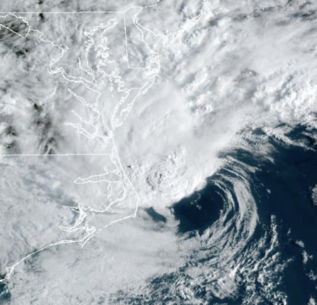
Perhaps because his tropical forecast is in bad shape due to a quiet hurricane season so far, Joe Bastardi is now insisting that meteorologists embrace his private fiction of what constitutes a tropical cyclone. As noted previously, the system had fronts. It was a nor'easter. It was not a tropical cyclone. It should not have been classified as a tropical cyclone any more than a winter nor'easter should be classified as a tropical storm or hurricane.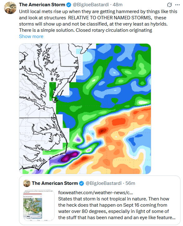
-
Just this morning a pro met (no, not JB) said the warm blob was strengthening. Funny how some live in the Land of Make Believe
-
I have to admit that it would be funny to see the NE Pacific cool back more than the W Pac and see how weenie forecasters would then spin it. Of course @snowman19would have a blast!
-
-
I think the opposite is true for La Nina....which is what the RONI reflects. The surrounding atmosphere is more of an impediment for the expression of warm ENSO.
-
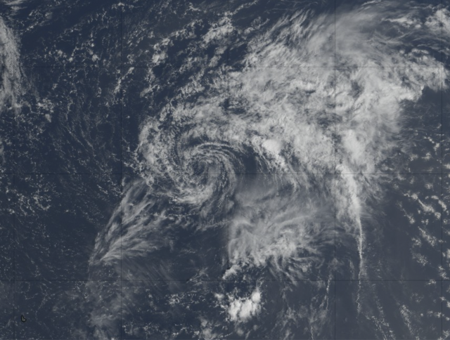
He was slow this time, but Bastardi finally this morning had his expected say about Gabrielle’s current anemic look vs the NC/VA no name system: What a Joke. Stratocu Swirl Gabrielle Then Joe compares satellite images of the two: Gabrielle: now a naked swirl but still being called a TS Offshore NC/VA nontropical low: was never tropical and thus was never a TS but unlike Gabrielle now it did have some nearby convection/tropical characteristics at this point: What JB especially doesn’t like is the inconsistency more than whether or not the offshore NC/VA nontropical low should have been named (he was wishy-washy on that). He thinks Gabrielle should be downgraded though I have to admit it still has a very tight tropical swirl unlike no-name.
-
-
Heck....just tap into the well and give him a refillable water trough :-)
-
Weather-related shock therapy?
-

2025-2026 ENSO
40/70 Benchmark replied to 40/70 Benchmark's topic in Weather Forecasting and Discussion
Not the case for New England. You tend to speak as though your climo applies to everyone. -
Just saw an all-brown wooly bear caterpillar. Torch winter inbound?
-
I have my station reporting on the PWS site. Here is a map of all the stations on there. Not sure if there was one in the area you were referencing. I am to the South of 340 west of 270. I got 2.89”. 3.28” for the event. https://www.pwsweather.com/station/map/pws/kmdfrede232?ob=temps
- Today
-
that's probably going to be a pretty good radiational cooling/frost result Saturday night.. probably all the way down here in interior SNE, too
-
September 2025 OBS-Discussion centered NYC subforum
donsutherland1 replied to wdrag's topic in New York City Metro
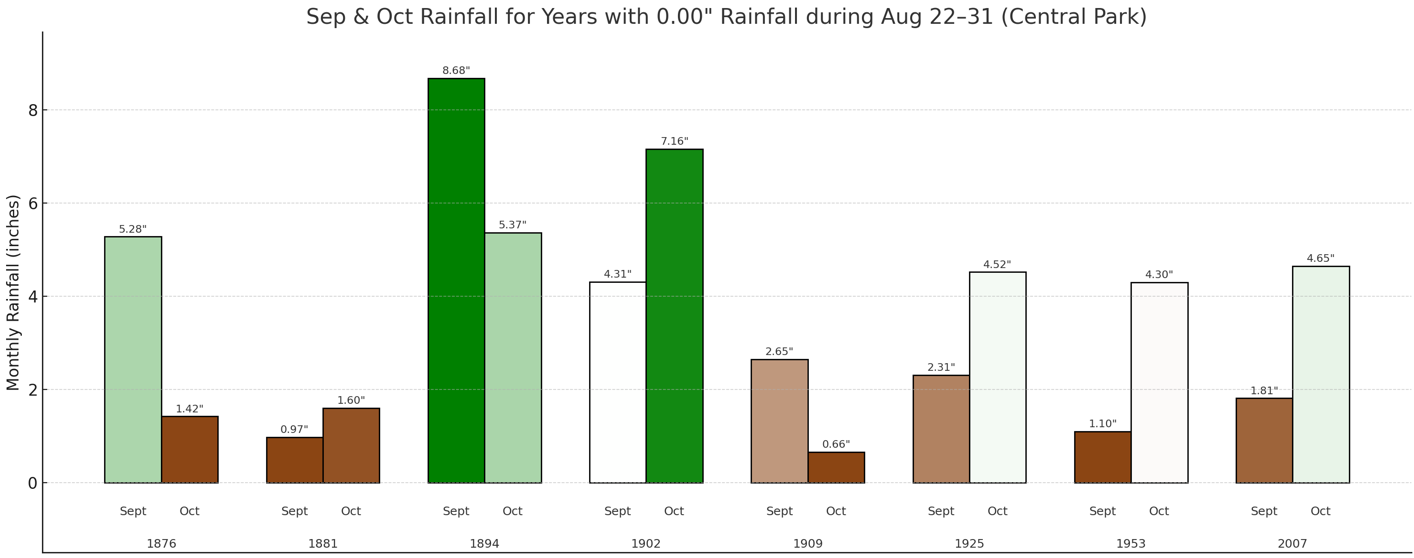
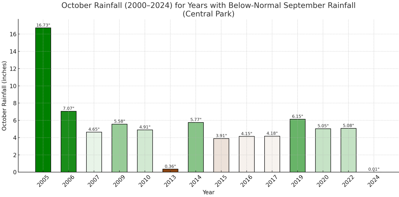
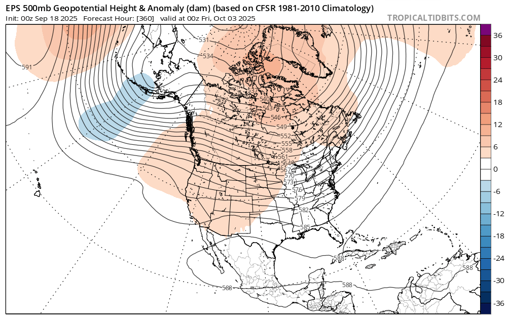
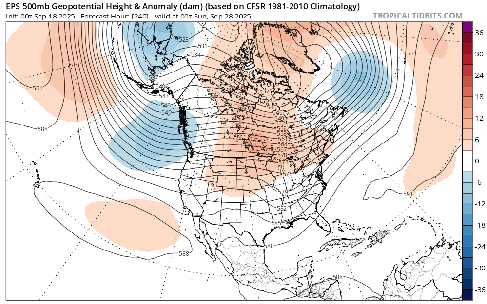
The overall dry September is consistent with the exceptionally dry end to August that had occurred. Indeed, the monthly CFSv2 initially called for a wet September before finally reverting to a dry September. Despite early rainfall during the month, highlighted by an unusually wet week following such a dry end to August, monthly rainfall is now below normal in New York City. Central Park: September 1-18: 2.30" 1991-2020 Average: 2.52" The guidance shows little or no rainfall for at least the next seven days. Statistically, the odds would somewhat favor a rebound in rainfall during October. Since 2000, 64% of drier than normal Septembers were followed by somewhat wetter to wetter than normal Octobers. However, with quasi-resonant amplification driven by changes in the Arctic producing "stuck patterns" that lead to longer-duration patterns, a dry October is possible. Indeed, during the last 10 years, dry Septembers were somewhat more likely (56%) to be followed by a drier than normal October. The most recent such case was October 2024. At present, the CFSv2 is showing drier than normal conditions in the Northeast. The ECMWF weeklies also begin October with near normal to possibly drier than normal conditions. October 2005 saw greatly elevated rainfall due to tropical moisture. Moisture from Subtropical Depression 22 dumped 4.49" of rain during October 7-8. Another system moving along a stalled frontal boundary brought 8.64" of rain during October 11-14. Nassau and Suffolk County saw the heaviest amounts with Lynbrook picking up 14.82", Riverhead receiving 14.26", and Wading River seeing 14.52". Moisture from Extratropical Wilma enhanced rainfall from a developing system along a frontal boundary that saw 2.36" rain fall during October 24-26. The emerging 500 mb pattern could provide insight as one draws closer to October. Very dry Octobers (<1.00" monthly rainfall) 1990-2024: Very wet Octobers (7.00" or more) 1990-2024: The September 18, 2025 0z EPS at 240 hours and 360 hours leans toward a dry start: 240 Hours: 360 Hours: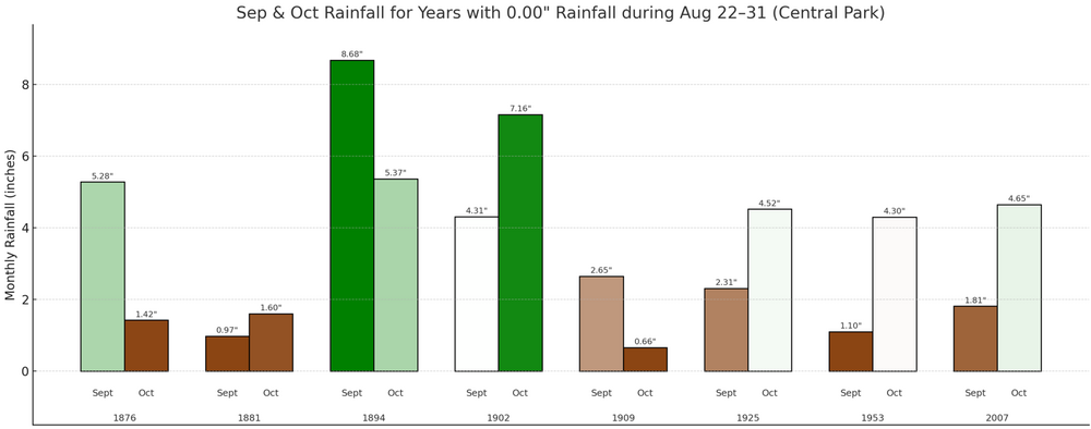


-

E PA/NJ/DE Autumn 2025 Obs/Discussion
soadforecasterx replied to PhiEaglesfan712's topic in Philadelphia Region
Ended up with 0.88" yesterday. -

September 2025 OBS-Discussion centered NYC subforum
jm1220 replied to wdrag's topic in New York City Metro
Feast or famine. Thank goodness we had the rain we did last week. -

September 2025 OBS-Discussion centered NYC subforum
bluewave replied to wdrag's topic in New York City Metro
It’s pretty wild how fast we dried out after that record deluge last August.

-
 Download this
 -
We're basically in a La Nina right now.
-
30 days here of 90° plus heat this season, last one back on Aug 18th. Normal is around 22 days... Highest 44 days in 2010.
-
I ended up with a total of 3.45". According to radar estimates, the jack zone was just to the northeast of me, north of 340 and west of Frederick. Anyone have a rain gauge in this zone?