All Activity
- Past hour
-
I live on a small hill, and usually can see evidence of rain runoff down to the roadside ditch when we get something like last night's 2.5. It was heartening that I didn't see too much of that this time. A "good" rain.
-
44.8 here this morning, felt incredible walking out the door
-
Yeah, it's probably just more noticeable now since one can now easily see it on phone radar apps, and before you'd never know that Sebago to Augusta was being hammered and you'd miss out.
-
Lows in this area were in the mid 50s, significantly below the low 60s normal. Dewpoints are still way down in the low 40s.
-
56 / 44 coolest of the next 10 or longer as the ull cutoff spins through with breaks of sun and isolated showers capped in the 60s. Ramp up and warm up Sat 80s - sun - wed 80s / 90s in areas - Peak heat is Tue and maybe Wed pending on the timing of the front with clouds. Next shot at rain is showers / storms from the front wed with potental >0.5 of rain. Ridge remains in the east and outside a ULL / custoff pegged around the Memorial day weekend (which could be split nice/vs not so nice ) TBD track, it looks overall warm - hot at times through then and beyond.
-
Let us be done with this cool nonsense. 56 degrees at 8:30.
-
Barry the goat
-

2026 Spring/Summer Mountain Thread
franklin NCwx replied to Buckethead's topic in Southeastern States
Had a low of 34 this morning. Feels like October -

Central PA Spring 2026 Discussion/Obs Thread
mahantango#1 replied to Voyager's topic in Upstate New York/Pennsylvania
This seems a little off as in my local where I picked up .88 of rain on Wednesday evening. The colors on the map show I only got .25-.50 US National Weather Service Middle Atlantic River Forecast Center · Follow · The latest drought monitor was released this morning and it's not good news for the areas already in drought. Although the extent has not changed, the severity of the existing drought increased. Over the past 24 hours, up to an inch of rain fell, but the heaviest amounts were mostly in areas unaffected by drought. The next 72 hours will not bring any relief as less than 0.25 inches, and increasing temperatures, are expected -

Central PA Spring 2026 Discussion/Obs Thread
Mount Joy Snowman replied to Voyager's topic in Upstate New York/Pennsylvania
Low of 49. Nice one today. My wife wanted me to turn on the heat the last two mornings. I’ve never scoffed at her so hard ha. -
Bring back may 06.
-
1.2” yesterday, 2.6” MTD
-
36 with light frost on elevated surfaces
-
We make our hay other times of the year, the problem lately has definitely been relying on summer to catch us up to normal precip. That just isn't likely to happen.
-
Impressive to send the Saco at Fryeburg to flood considering how low streamflow was before this.
-
Got to imagine the rivers in the white mountains draining to the east and southeast are raging pretty good right now after last night.
-
I know it feels like 90% of connective storms fizzle by the time they reach the coast, but I don't think that's a new thing, or that it's gotten worse in recent years. Missing 0.20" on a single cell a dozen times a year isn't going to make that much of a difference, I don't think. But your overall point is clearly accurate - the coastal has experienced more dry conditions than most places in the state.
-
I think the thunder thing is just climo. Storms are naturally going to fall apart as they near the colder water. One thing we have seemingly trended towards though is more rain in shorter periods of time. So while yearly precip could be normal or above normal, when we get rain it is too much too fast and it doesn't actually alleviate drought conditions.
-
Low was 36.3 degrees, not a record. That still stands at 33 degrees from 1984. The 49.9 degree high becomes new 'cool max'.
-
the consequences of increasingly intense industrial agriculture destroying our top soil + changing climate def getting worse
-
It's going to be nothing but bare napes and hairy arms out the window up here if we can just get a stretch of normal temps.
-
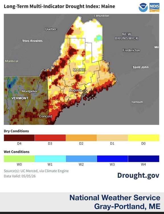
Nearly 2.5 inches overnight. Gyx issued its most recent drought update for Maine and NH, discouraging as usual. What caught my eye was this historical five year map of drought, and the coastal strip of high drought. To my experience in recent years, this lines up with what seems to be increasing phenomenon of a really strong marine layer due to stout south/southeast winds in summer shredding frontal thunderstorms that approach the coastm from the mountains. Is that possible, that we're seeing fewer coastal t-storms in summer due?
- Today
-
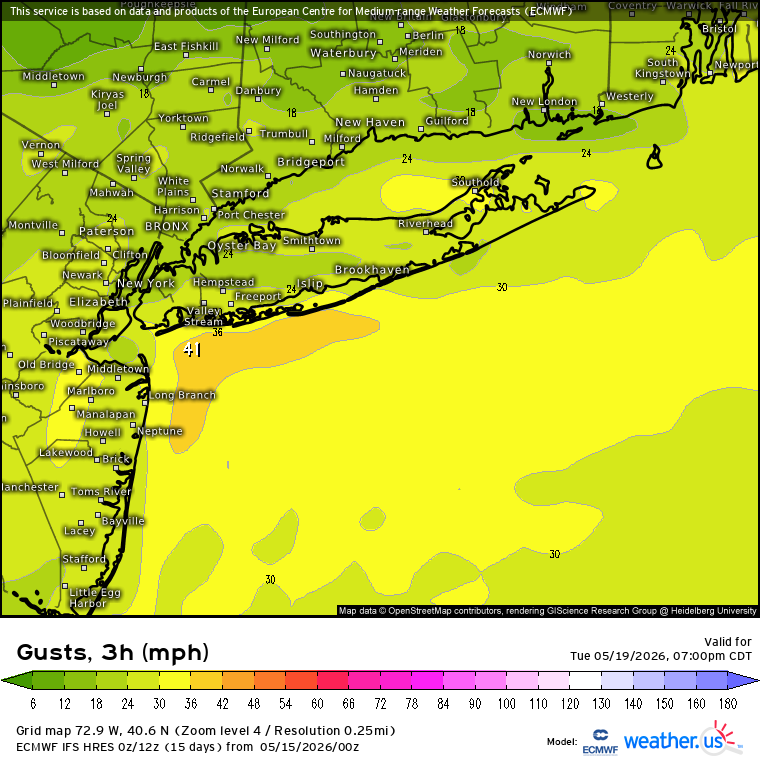
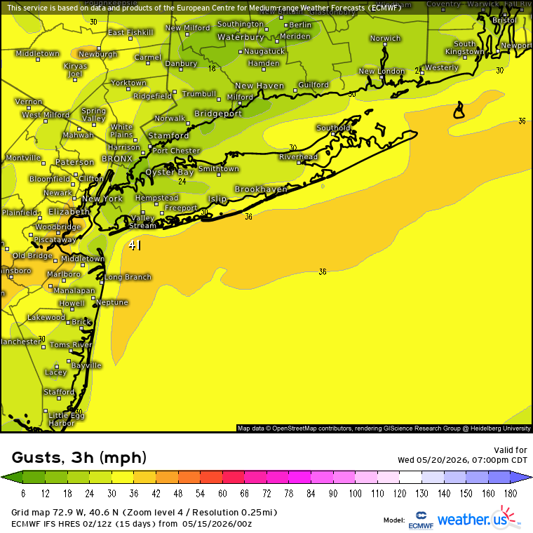
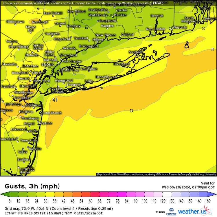
Yeah, I can remember days like this living in Long Beach. Current forecast is for 40mph or higher SSW gusts along the South Shore Tuesday and Wednesday. So plenty of dangerous rip currents expected. People should stay out of the water especially before the lifeguard season starts.
-

Central PA Spring 2026 Discussion/Obs Thread
Blizzard of 93 replied to Voyager's topic in Upstate New York/Pennsylvania
Beautiful day underway today before the heat builds for a bit. It should be a good evening to get the yard work done to avoid sweating over the weekend. -
2.40" First time >2" (by 7a-7p CoCoRAHS obs) in over 2 years.