All Activity
- Today
-
Hm...well then there's the other part of bringing up your best prospect and having them sit on and off the bench just to avoid the 130 mark. Teams may prefer more consistent playing time for the best ones? Just speculating
-
I have one of those. It's a good Station overall. Accurate T, RH, Rain, Solar. 14 second updates not bad for budget Station. Biggest con is Windspeed runs low the higher the Winds, at least with mine. Customer support is good. I also have a Logia 7-1 . It has been very accurate overall. It was right with my Davis irt accuracy. T Sensor failing after 3 year's.
-
Anthony? Is that you?
-

2025-2026 Winter Speculation Thread
WintryMixmaster replied to Carvers Gap's topic in Tennessee Valley
That is a good point, I forget how different the weather can be between downtown Knoxville and TYS (January 2024 had a sharp cutoff for accumulations right by the airport too). My first 3 winters here were spent in Hardin Valley and I remember being jealous of the Powell/Fountain City area posters that often had just a bit more elevation and were a bit further northeast. Last winter was my first winter in the Concord/Northshore town center area and I'm dreading the inevitable storm where Hardin Valley gets snow and I see nothing -
2025-2026 Winter Speculation Thread
WintryMixmaster replied to Carvers Gap's topic in Tennessee Valley
Well hopefully I'm good luck for Knoxville- I remember that March 2022 snowstorm and being a bit sad thinking I might never see that kind of storm again here... and then January 2024 came around haha. I did notice that the tri-cities seemed to get the short end of the stick these past few winters despite averaging more snow than Knoxville, it's really interesting how the shape of the valley influences which storm types are better/worse for which areas, despite how geographically close TRI/TYS/CHA all are. Blount/Sevier counties got warm nosed in January 2024, but they also get some solid accumulation during NW flow events while in West Knox I've usually seen flurries or a dusting at best from those. Chattanooga seems like a snow lovers nightmare where anything that can go wrong will go wrong, I was glad they finally got to cash in last January. I remember the post you're referencing about the natural spillway for cold air into the valley and it makes sense that it would work in favor of the Knox area. This might be a dumb question, but do you think that there's a correlation between the very strong pacific jet stream that we've seen in recent winters and the shift in snow between the tri-cities and Knoxville? As a novice, it seems like Nor'Easters and Apps runners/Great Lake cutters are less common than I remember from the 2002-2010 period when I followed the weather more closely - but sliders that move west to east and weaker storms that ride along a frontal boundary are more common, and Knoxville has cashed in when one of them is timed correctly with a shot of cold air that briefly buckles the flow. Would the ideal storm track for TRI be something that is more south to north, so that a strengthening storm east of the valley would bring winds from the north? -
True. But keep in mind the heights in my plot are being skewed lower by some of the older years being measured against today’s means. The same pattern as say a 1958 or 1960 wouldn’t produce nearly as negative an anomaly today (by 1960s standards) and a might more positive anomaly over the high latitudes as well. Of course we could argue whether the same pattern would even produce similar snow now given the mean heights have increased significantly.
-
How does this relate to enso? Oh yeah, it doesnt
-

Eastern Tropical Atlantic Wave - 0/20
BarryStantonGBP replied to BarryStantonGBP's topic in Tropical Headquarters

-
2025 Atlantic Hurricane Season
BarryStantonGBP replied to BarryStantonGBP's topic in Tropical Headquarters
K -
Talk about a heater. Basically two islands in the gigantic expanse of the Atlantic basin getting all the hits. It’s worse than Moose Glute, ME getting all the snow.
-

Eastern Tropical Atlantic Wave - 0/20
WxWatcher007 replied to BarryStantonGBP's topic in Tropical Headquarters
Idub is that you? -
how does Brady statue look? goated? I forgot about that
-
the new Florida. hit after hit
-
You'd be worse off tonight. Luke Bryan and the Patriots. Good luck getting back to lowell .
-
Think of our Atlantic Canada friends!
-
45 days on Mlb roster prior to September 1st or 130 at bats. That's what makes them not a rookie. Are they worried they are going to end up over 130 ab's?
-

2025 Spring/Summer Mountain Thread
Tyler Penland replied to Maggie Valley Steve's topic in Southeastern States
Been busy this summer so haven't been on the forum much. Absolutely loving this weather. I went out to Yellowstone and the Beartooths and brought their temperatures back with me so you're welcome. LOL -

Central PA Summer 2025
Mount Joy Snowman replied to Voyager's topic in Upstate New York/Pennsylvania
Not sure what the weenie emoji was for on this post, as MDT has also started with a negative departure every day this month. -
CAMs (18Z 3K NAM/0Z HRRR) aren't too enthused about much more than garden variety tomorrow. EHI is pretty low. SPC may have been over-optimistic expanding the slight risk into all of S. WI and adding a 2% tornado contour. Edit: 0Z 3K NAM is quite a bit more aggressive than the previous couple of runs. Hard to pin anything down with such lack of agreement/consistency.
-
i was in the dead-center of this, working night-shifts in Mansfield MA. Driving home. I honestly didn't know if i was gonna make it. lol http://users.rcn.com/rmacedo/aug10.htm
-
 I saw those as well as willets and black crowned night herons.
 -

SE Area of Interest--10% two day, 20% five day odds
Kevin Reilly replied to WxWatcher007's topic in Tropical Headquarters
What that storm did do is up well the waters pretty good here in Kitty Hawk water temp has gone from 84 to 75 in the past day or so; I am sure this is temporary. -
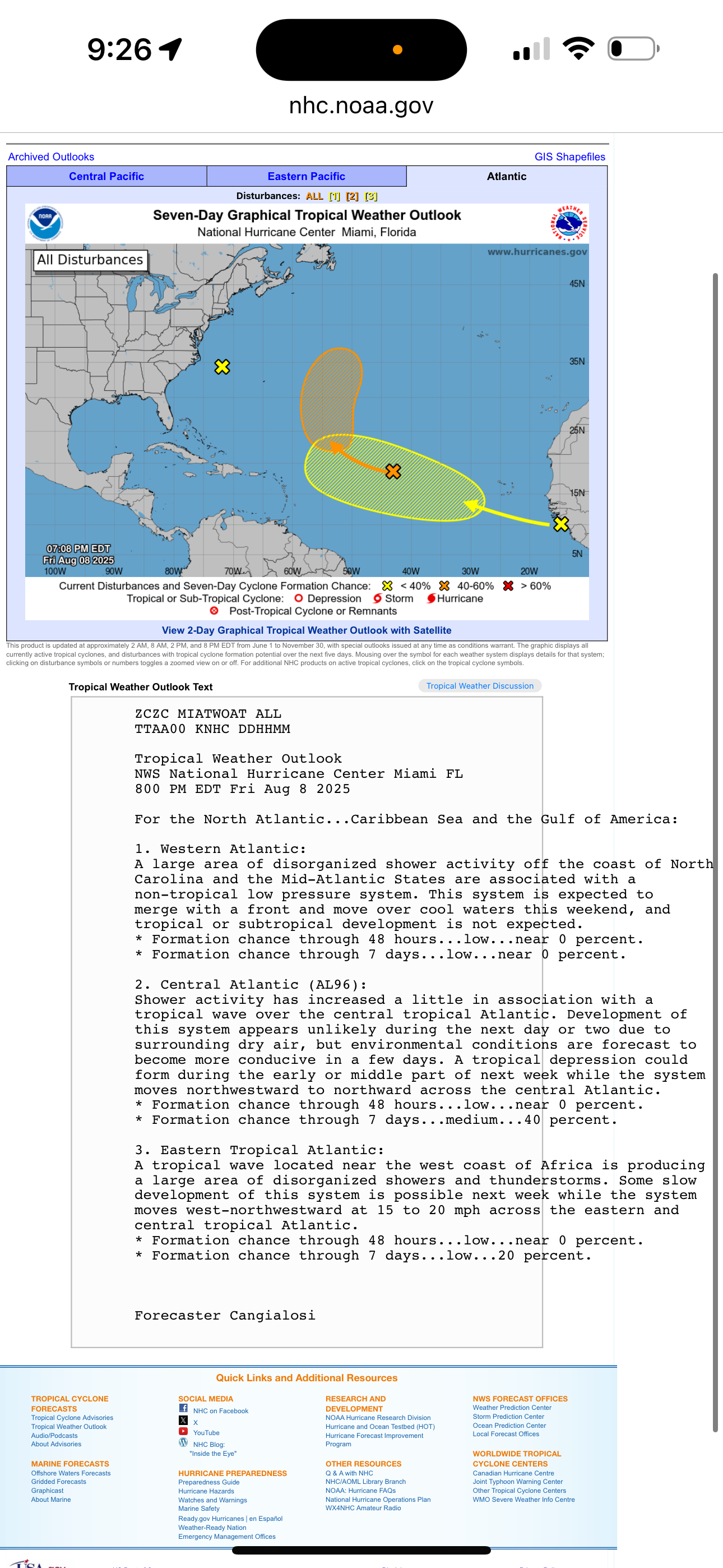
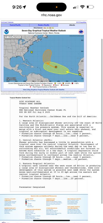
NHC at 8pm. Eastern Atlantic is the wave to watch.
-
 Happy Friday everyone.