All Activity
- Past hour
-
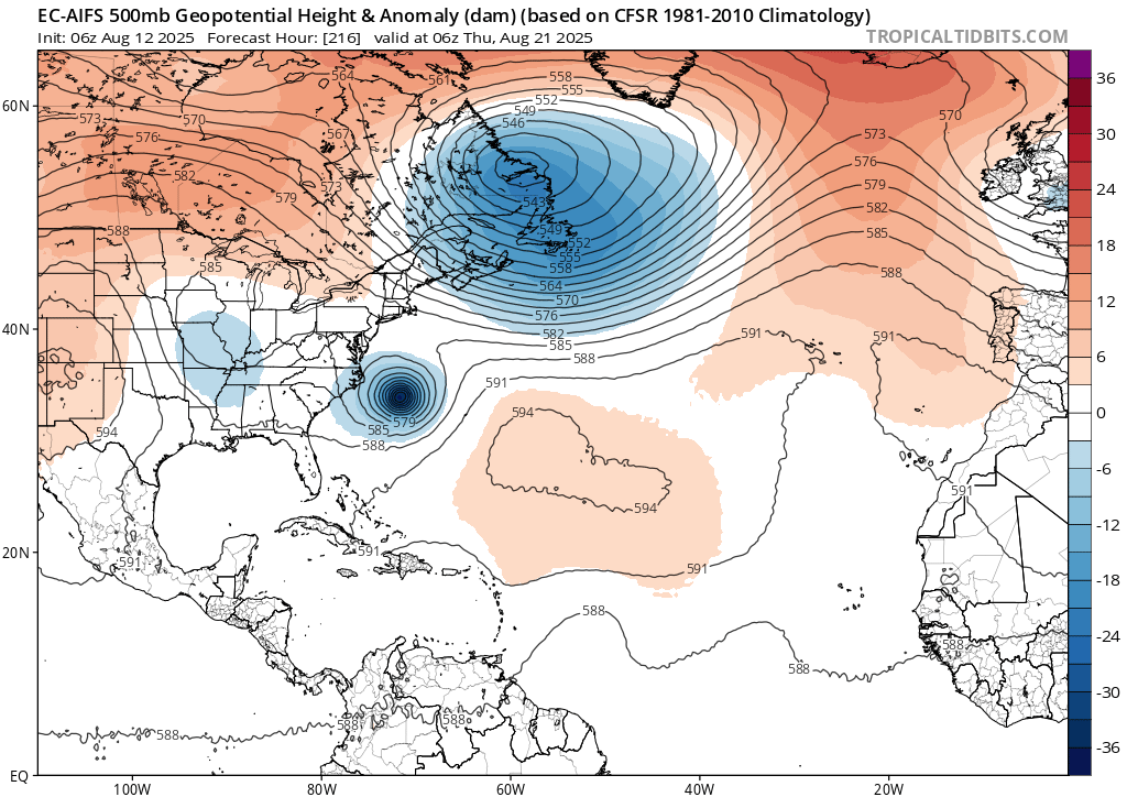
 It was pretty much wall to wall heat and ridging from June 21st through July 31st. We got a relaxation of this pattern for the first week of August. This current heat wave is a weaker reflection of what we got back in June and July. So the shift in the modeling for next week is the hurricane lowering heights in the East as it recurves west of Bermuda. Would like to see some improvement in the rainfall situation. Since we have seen time and time again how heat has remerged in September into October during dry patterns. We would at least need to keep the tropics active in Atlantic to have a shot at avoiding potential fall record heat when the pattern has been so dry.
 -
Some isolated thunderstorms are possible today! Barring a surprise, 90 looks likely today, and low 90s look increasingly likely for both days this weekend. Friday and Monday, it looks unlikely, but close enough that a small change in the forecast could allow us to reach 90F on one of those days. With the current forecast, we could be up to 18 days of 90+ by Sunday. Can we reach 20? Believe it or not, the last time there were two consecutive years with 20 or more days of 90+ in Pittsburgh was 1933 & 1934 (when observations were downtown). There were 21 days in both 1933 & 1934, so it barely accomplished that feat. 1987 & 1988 was very close. Of course, 1988 had tons of 90F heat, with 1987 finishing with 19 days.
-
Yep, they've been quite loud the past week or so. Definitely giving those hot day vibes. On another bug observation note....we still have deer flies buzzing around these parts. Granted not as many as June and early July, but usually they are completely gone by late July. So running a couple weeks overtime at this point.
-
That's a lot ot get rid of lol
-
Yes I am.. looking at trends.. to the west is looking better just have to get rid of that crap to the NE

-
Yeah, that to me is the takeaway, back n forth w/ humidity is ok to many, as humidity is expected in the dog days...
-
Are you just blatantly ignoring what all the meteorologists have posted above you lol
-
Some of the more notable high temperatures reported by ACIS for the Pine Tree State, include: 99 at the Houlton Band of Maliseet Indians Tribal Soil and Climate Analysis Network station, 98 at Augusta State Airport and Dixfield, 97 at Fryeburg and Millinocket, and 96 at Bangor. Among co-coops reporting in the morning (attributed to the following day - i.e., today), Topsfield 2 reached 98 and Van Buren 2 topped out at 95. The 99F reading at the HBMI TSCAN site matches the highest temperature reported by ACIS for the month of August in the State of Maine since 2002. The last time it reached 99F (as per ACIS data) in the state of Maine during the month of August was on August 12, 2016 at Portland Jetport Airport. The last time it reached 100F+ was August 15, 2002, when it topped out at 101F at Livermore Falls 1 E. Fryeburg topped out at 100F on the day prior (August 14, 2002). Above is a partial listing of all highs >92F for August 11, with all of the late reporting data below.
-
Did you look at 6z unless they all turned right after that.. some might have been good
-
It's coming..
-
Ended with .36" here, of which .30 fell this morning. Been the summer of near misses IMBY where we are barely keeping drought at bay while areas just north and south are more lush.
-
All it means is more an abrupt turn to the right.
-
There is not one EPs member near SNE. Move on folks.
-
 Eastern North America is night and day
 - Today
-
12Z hurricane models shifted and are on the left side of the GEFS
-

2025-2026 ENSO
donsutherland1 replied to 40/70 Benchmark's topic in Weather Forecasting and Discussion
The IOD has been declining in recent months and has already turned negative. It seems that things are on track for the forecast.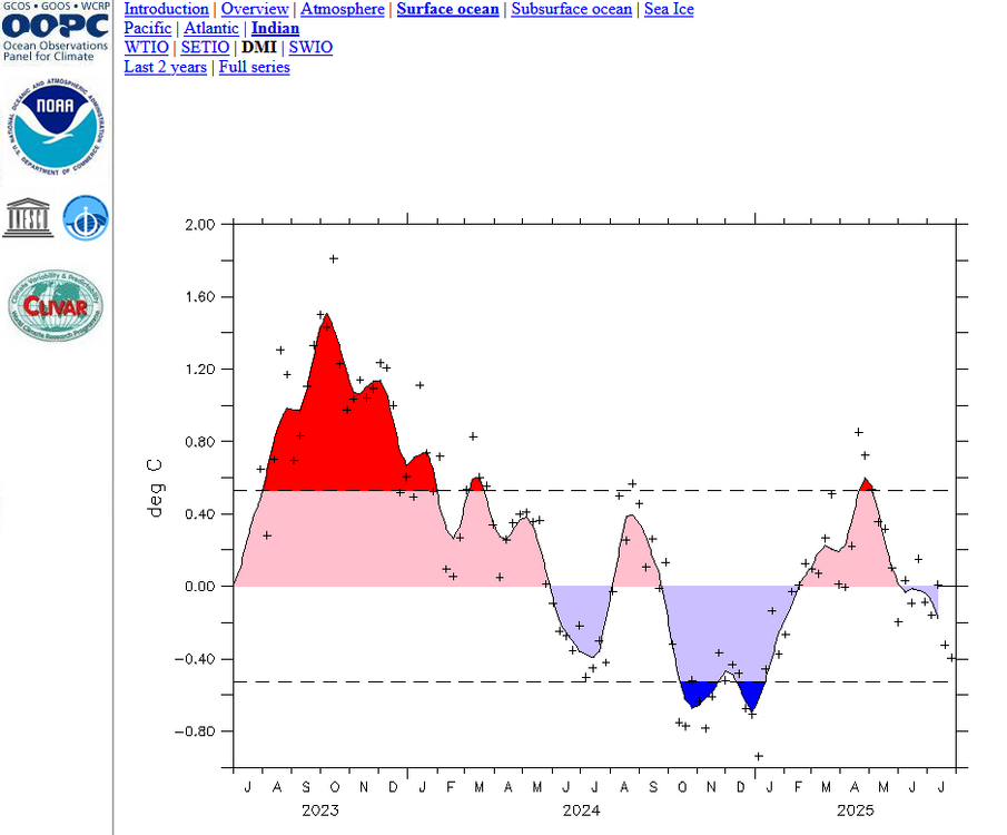
-
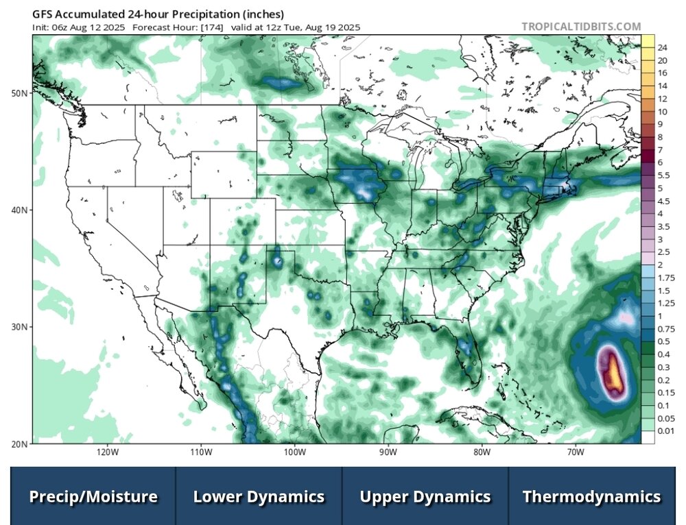
You don't need to look far to see why Erin is struggling convectively this morning. First, it's still in a marginally favorable SST environment Second and more important, it is plowing into an area of drier, more stable atmospheric conditions--something that was anticipated days ago. The microwave image I posted last night was illustrative of its organization, which still exists this morning. Note the well defined center and its symmetrical nature. Note also the more stable conditions to its northwest. This should keep Erin in check for a bit, but given the internal organization, if that doesn't fade once this finds a more favorable environment it should still be primed to ramp up. As for track, I still think it's highly unlikely to directly impact the US coast, but Atlantic Canada should be monitoring more closely.
-
Thanks pasnownut!
-
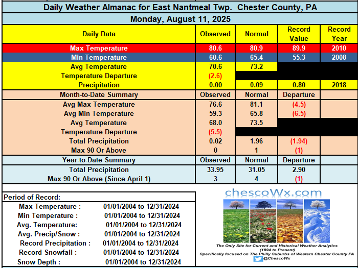
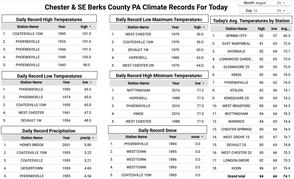
Yesterday was our 11th straight below normal temperature day here in East Nantmeal to start the month of August. Today we should finally see above normal temperatures and they look like they should last through the week and into the weekend. We should see temperatures in the mid to upper 80's for the rest of the work week and maybe reaching the 90's by Sunday. We have been dry so far this month so the potential shower later tomorrow into the evening will be welcomed by our many area farmers and green thumbs.
-

E PA/NJ/DE Summer 2025 Obs/Discussion
ChescoWx replied to Hurricane Agnes's topic in Philadelphia Region
Yesterday was our 11th straight below normal temperature day here in East Nantmeal to start the month of August. Today we should finally see above normal temperatures and they look like they should last through the week and into the weekend. We should see temperatures in the mid to upper 80's for the rest of the work week and maybe reaching the 90's by Sunday. We have been dry so far this month so the potential shower later tomorrow into the evening will be welcomed by our many area farmers and green thumbs.
-
While I understand some folks wanting to fantasize, especially during pitifully boring times, in the history of East Coast hurricane forecasting, nothing has changed! The major pattern players are always the same, as Ryan, Tip and Coastal have pointed out; anomalous positive heights in the northwest Atlantic (Newfound wheel) and troughing moving east or digging southeast from TN/OH valley region. There are other setups that can tease a coastal run, but they inevitably bend east/northeast. Of all the SNE storm patterns, the hurricane threat pattern is actually one of the easiest to pick out! And this setup would need massive changes to morph into meaningful threat. Forget about tracking every little shift in Erin's track. Look north and west for the answer!
-
The maritimes have been on a generational run. Seriously.
-
First time in nearly a week that my glasses fogged up walking outside this morning. In August, I call that a win.
-
Yeah maybe something more substantial early next week.
-
Those cicada/'saw bugs' are out there deforesting already and it's not even 9am... Heh, it 'sounds' like a hot day is in the mail.