All Activity
- Past hour
-
Records: Highs: EWR: 91 (1974) NYC: 89 (1974) LGA: 88 (2017) JFk: 85 (2017) Lows: EWR: 35 (1947) NYC: 32 (1874) LGA: 39 (1977) JFK: 36 (1968) Historical: 1905 - The town of Taylor, in southeastern Texas, was deluged with 2.4 inches of rain in fifteen minutes. (The Weather Channel) 1910 - The temperature at Kansas City, MO, soared to 95 degrees to establish a record for the month of April. Four days earlier the afternoon high in Kansas City was 44 degrees, following a record cold morning low of 34 degrees. (The Weather Channel) (The Kansas City Weather Almanac) 1963 - A tornado, as much as 100 yards in width, touched down south of Shannon, MS. The tornado destroyed twenty-seven homes along its eighteen mile path, killing three persons. Asphalt was torn from Highway 45 and thrown hundreds of yards away. Little rain or snow accompanied the tornado, so it was visible for miles. (The Weather Channel) 1973 - The Mississippi River reached a crest of 43.4 feet, breaking the prevous record of 42 feet established in 1785. (David Ludlum) 1987 - A storm off the southeast coast of Massachusetts blanketed southern New England with heavy snow. Totals of three inches at Boston MA, 11 inches at Milton MA, and 17 inches at Worcester MA, were records for so late in the season. Princeton MA was buried under 25 inches of snow. (The National Weather Summary) (Storm Data) 1988 - Thunderstorms produced large hail and high winds in central Texas. Baseball size hail was reported at Nixon, and wind gusts to 70 mph were reported at Cotulla. Heavy rain in Maine caused flooding along the Pemigewassett and Ammonoosuc Rivers. (The National Weather Summary) (Storm Data) 1989 - Thunderstorms produced severe weather in Arkansas, Louisiana and eastern Texas, with more than 70 reports of large hail and damaging winds. Softball size hail was reported at Palestine TX. Hail as large as tennis balls caused ten million dollars damage around Pine Bluff AR. (The National Weather Summary) (Storm Data) 1990 - A storm system crossing northern New Mexico blanketed parts of the Rocky Mountain Region and the Northern High Plains with heavy snow, and produced blizzard conditions in central Montana. Much of southern Colorado was buried under one to three feet of snow. Pueblo tied an April record with 16.8 inches of snow in 24 hours. Strong canyon winds in New Mexico, enhanced by local showers, gusted to 65 mph at Albuquerque. Afternoon temperatures across the Great Plains Region ranged from the 20s in North Dakota to 107 degrees at Laredo TX. (The National Weather Summary) (Storm Data)
-

Central PA Spring 2026 Discussion/Obs Thread
Blizzard of 93 replied to Voyager's topic in Upstate New York/Pennsylvania
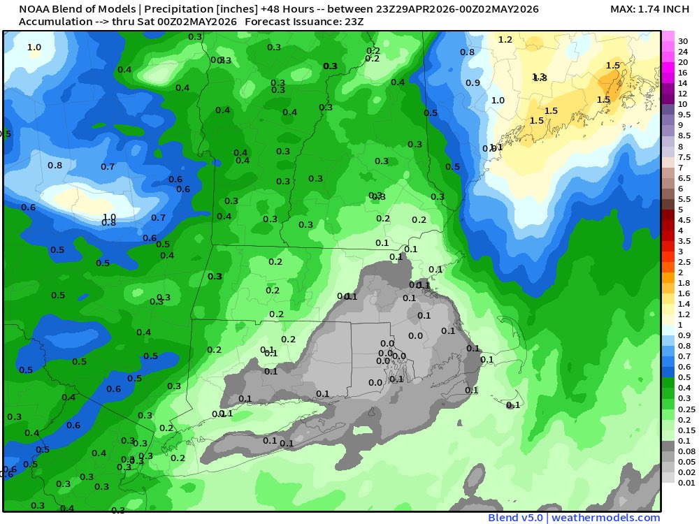
That heavy band delivered. .60 of rain total today in Marysville. -
Central PA Spring 2026 Discussion/Obs Thread
Blizzard of 93 replied to Voyager's topic in Upstate New York/Pennsylvania
Flyers advance! -
Thank god
-

Texas 2026 Discussion/Observations
Stx_Thunder replied to Stx_Thunder's topic in Central/Western States
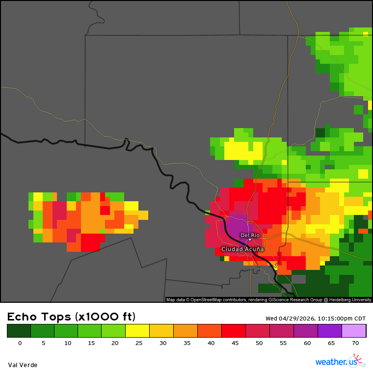
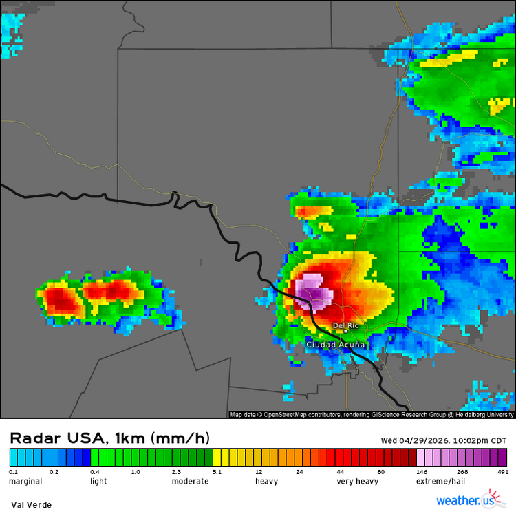
Solid supercell literally moving right over Del Rio right now. Hailstones could be even bigger than the 5 in. diameter report in Camp Wood a few hours ago. Definitely over 60 Kft tops. But could be very close to 70 !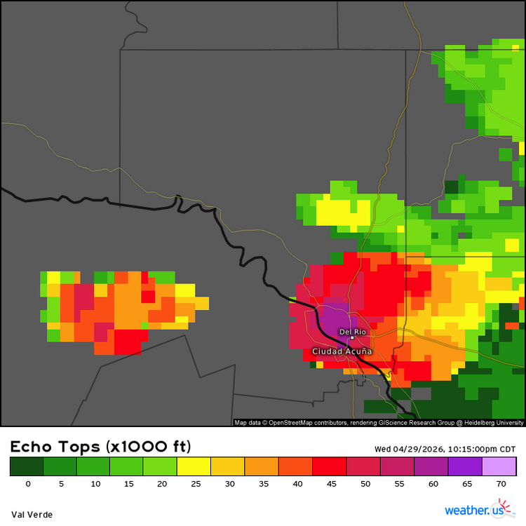
-

2026-2027 Strong El Nino
michsnowfreak replied to Stormchaserchuck1's topic in Weather Forecasting and Discussion
Hmm while im not as familiar with east coast climate, that seems pretty much impossible to get a total shutout in new England. Shitty compard to climo, yes, but shutout or even close, never. Im in SE Michigan, i turn 43 next week and the least snowy winter Detroit has recorded during my lifetime was 23.4" in 1997-98. 2023-24 was right there at 23.5". Go north in Michigan and snow towns were calling 2023-24 with its 60, 80, 100" a "non-winter". So all of this worry about the worst case scenarios is STILL relative to one's climo. Even IF its a strong or super nino, many other factors come into play too. So I can say with 100% confidence that any area north of NYC will not be shutout. - Today
-
Pouring rain here now and windswept near RDU. This is great as we need it
-
.65 nw Cecil County :)
-

Central PA Spring 2026 Discussion/Obs Thread
canderson replied to Voyager's topic in Upstate New York/Pennsylvania
.54” rain today -

Central PA Spring 2026 Discussion/Obs Thread
Itstrainingtime replied to Voyager's topic in Upstate New York/Pennsylvania
YES!!! -
Texas 2026 Discussion/Observations
Stx_Thunder replied to Stx_Thunder's topic in Central/Western States
Yep. 5 in. diameter happened today with the DRT - SAT lone supercell. And still have some potential tomorrow (Thursday).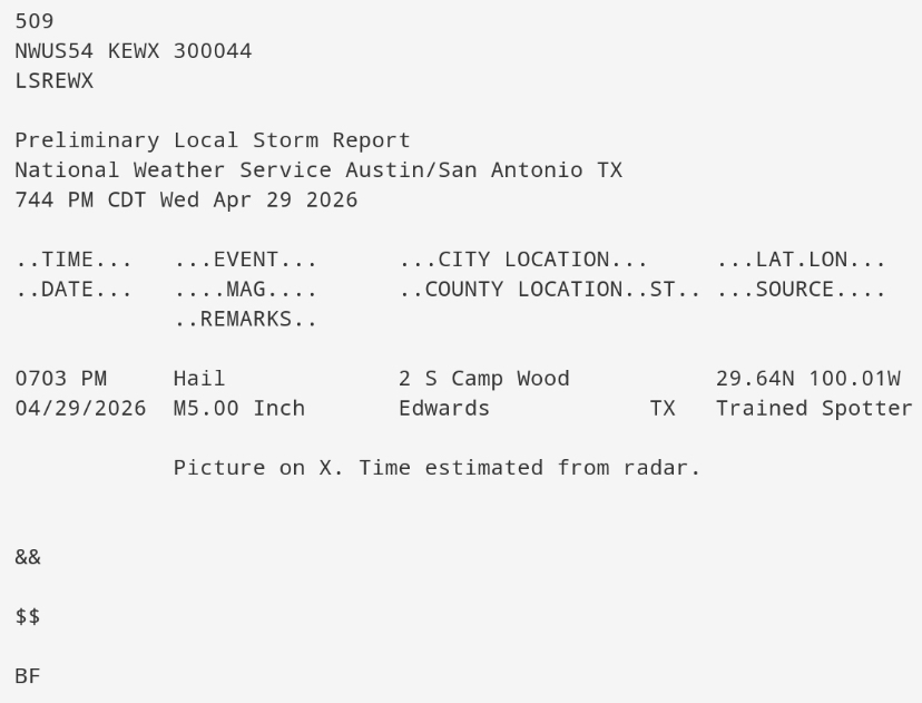
-
0.49", dzl at obs
-
Nice little line of storms in north Orange and Guilford counties tonight. Saw the lightning when i left work tonight at RDU.
-
We need a good 3+ day streak of 70+ temps region wide. 46 and misery mist just ain’t cutting it. This orange glow must be maintained at all costs!
-
Nice steady to almost heavy rain in Gainesville.
-
Texas 2026 Discussion/Observations
Stx_Thunder replied to Stx_Thunder's topic in Central/Western States
Up to 3.5 in. hailstones reported so far this evening from ongoing supercell between Del Rio - San Antonio, in Camp Wood. More severe-warned cells are coming up further west in SWTX. Which likely means next ML shortwave is entering the state in WTX. -
We have a Nostradamus among us…. Or should I say Tipstradamus?
-
Love talking Stein! Drought !!
-
It will be rainy tonight into tomorrow morning. A general 0.50"-1.00" rainfall appears likely. Following the rainfall, temperatures will top out in the lower to perhaps middle 60s through Saturday. May will likely open with cooler than normal conditions. Sunday could be especially cool with highs only in the upper 50s despite partly sunny skies. The ENSO Region 1+2 anomaly was +1.5°C and the Region 3.4 anomaly was +0.7°C for the week centered around April 22. For the past six weeks, the ENSO Region 1+2 anomaly has averaged +1.47°C and the ENSO Region 3.4 anomaly has averaged +0.27°C. El Niño conditions will likely develop during late spring or early summer. The SOI was -5.41 today. The preliminary Arctic Oscillation (AO) was +0.224 today. Based on sensitivity analysis applied to the latest guidance, there is an implied near 100% probability that New York City will have a warmer than normal April (1991-2020 normal). April will likely finish with a mean temperature near 55.2° (1.5° above normal). Supplemental Information: The projected mean would be 2.2° above the 1981-2010 normal monthly value.
-
Next week there’s 2-3 days of low -mid 70’s at least. One day has 75+ potential
-
Snow showers this evening. Chilly day.
-
He’s got an itchy trigger finger . I think he senses the dry summer coming https://x.com/growingwisdom/status/2049636199933858274?s=46&t=dhcbvkjmRcyBVQtDxJ3lRg
-
Hard to believe my area has only been 'abnormally dry'. With the update tomorrow I expect to be in moderate drought category.
-
73 at CEF today. Could be the last 70+ here for a bit from what i read in these spaces
-
Yeah looks like a nothing burger again. Maybe a tenth, which is what I expected.