All Activity
- Past hour
-
https://x.com/pettuswx/status/1982527974378217764?s=49
-
Going to be a raw week with highs in the 40s most of the week with rain. Also I still like our chances for high elevation snow towards the end of the week.
-
942mb on the latest VDM
-
Heck yeah!
-
More realistic time frame. Sent from my SM-G998U using Tapatalk
-
IR satellite imagery really starting to ramp up again. Cloud tops rapidly cooling especially in the southern part of the circulation.
-

Spooky Season (October Disco Thread)
powderfreak replied to Prismshine Productions's topic in New England
Haha I didn’t see anyone worrying about ice free Arctic… just discussion. The WinterWolf time is back… keep everyone in line with a quick show of the teeth. It has been a nice fall for sure. -
Seems like Melissa is entering another RI phase.
-
Your using a 300 hour map? Interesting.
-
939.9 extrapolated Unflagged 129kt FL and 132kt SFMR.
-
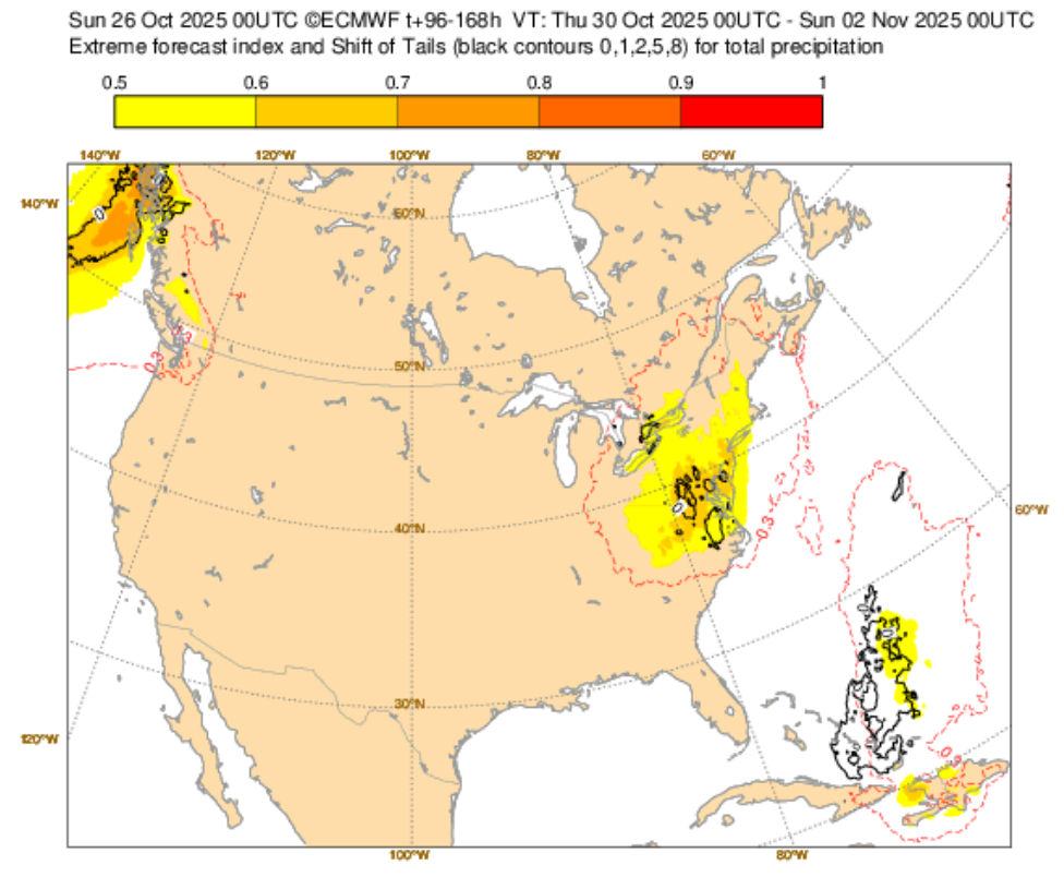
The idea of a significant rainfall across the New York City area remains on track. The latest EFI shows the spatial area of significant rains. Based on the overall guidance, noting that there is some uncertainty about the placement of the heaviest rains, a general 1"-3" multi-day rain event appears likely.
-
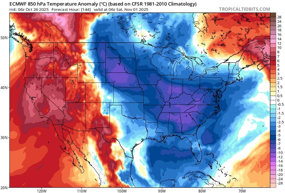
6z gfs. Nuff said. There will be at least a period of warmer wx after this extended cool period but doubt that warm .
-

Spooky Season (October Disco Thread)
Lava Rock replied to Prismshine Productions's topic in New England
Fangs are a bit premature, lol Sent from my SM-S921U using Tapatalk -
Yeah. Mentioned to my Wife awhile ago that possibly some flurries or Snow showers Thursday night. If enough cold can get pulled down there could be some decent accumulations up high.
-

Mid to long range discussion- 2025
SEwakenosnowforu replied to wncsnow's topic in Southeastern States
I would definitely take 80s in November as long as we get a hard freeze out of the way first. Let the cold come in December or January! -
Very fascinating stuff. Thank you for sharing
-

Spooky Season (October Disco Thread)
WinterWolf replied to Prismshine Productions's topic in New England
There will never be an ice fee Arctic in our lifetimes or our kids lifetimes…that’s total horse sh*t, bet on it. How’s that for knowing. And worrying about pacific air in late October…is ridiculous. And the upcoming pattern doesn’t look zonal that’s for sure. And mid 50’s for highs with sun and clouds is gorgeous autumn weather…exactly what we have, and as it should be. Loving this weather. - Today
-

Spooky Season (October Disco Thread)
Torch Tiger replied to Prismshine Productions's topic in New England
no argument, but it's still no bueno here. Maybe some ImpAcTz Bermuda/E Canada I suppose -
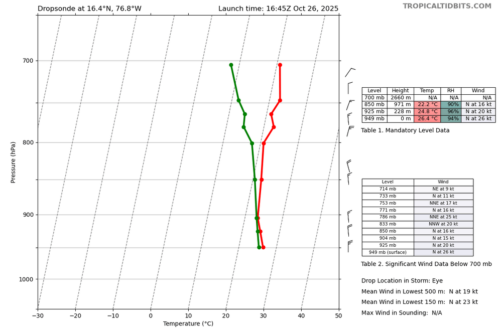
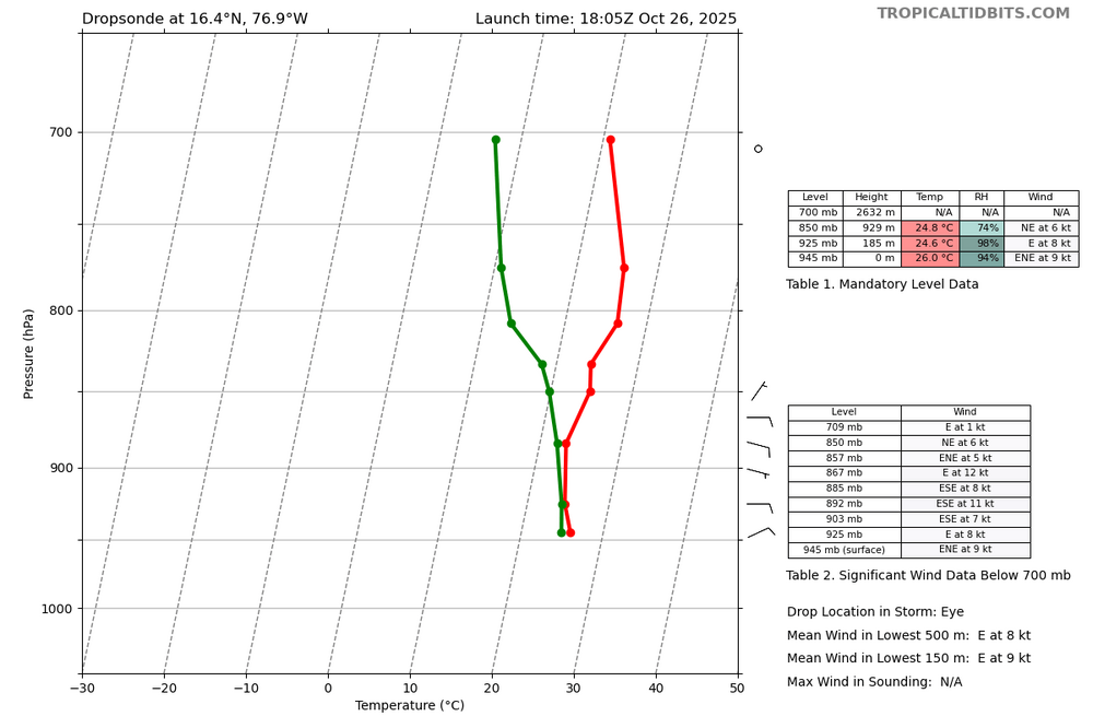
Latest dropsonde data supports Melissa is not only intensifying but is likely hours away from another potential rapid intensification process. Both images are 2 hours apart, and show an incredible structure change to Melissa’s eye. So while the internal process is not an ERC, it was very much structural and likely about to wrap up. The internal process was truly hindering mixing. First pass subsidence was not fully established. The second pass subsidence is highly noted. This is a precursor to a high-end hurricane going nuclear.
-
Wouldn't area also be a factor? E.g. reduced area during EWRC could theoretically result in increased wind speed while keeping kinetic energy the same right? (or vice versa - total kinetic energy could be increasing while wind speed remains about the same?)
-
With Melissa being a small, compact storm it’s possible they haven’t found the “sweet spot” in the northeast quad. Ive seen in years past where recon sometimes miss the sweet spot with these small compact systems. Other thing to consider is Melissa is undergoing some sort of internal process. Not an ERC but there are many different types of internal processes that a cyclone can undergo.
-
Dropsonde says ~944 mb.
-
I wonder why wind isn't responding with such big pressure drops and a relatively small storm. Kind of odd. If it was bigger or actively going through EWRC would make more sense.
-
The wind still hasn't risen at all today. Satellite looks like cat 4, but recon hasn't found any cat 4 FL wind.
-
The Ravens not running the ball is a mystery to me.