
All Activity
- Past hour
-

Central PA Summer 2026 Discussion/Obs Thread
Blizzard of 93 replied to Voyager's topic in Upstate New York/Pennsylvania
.62 in Marysville today. -

Augdewst 2026: Summer's Last Stand
WxWatcher007 replied to Prismshine Productions's topic in New England
Man useless is a great way to describe it. When I’m out in SLK or traveling up there I don’t even bother with it. -

Augdewst 2026: Summer's Last Stand
Snowedin replied to Prismshine Productions's topic in New England
If my memory serves me correct, I believe temps took a noticeable trend downwards after one final surge in mid August. I suppose it depends on what part of the region people are from too. For me, as long as the air still has that summery “feel” to it and am able to squeak out a few more good beach or fishing trips, then I’m a happy camper. Let’s hope for the best, dew and coc enthusiasts alike! -
Augdewst 2026: Summer's Last Stand
WxWatcher007 replied to Prismshine Productions's topic in New England
We had the hot period right around this time, but I also had ten days with highs in the 70s, one day in the 60s, and thirteen days with lows below 55° when the avg low is 59 at BDL on 8/31. -
It looks like the mode will be slow moving semi-supercells just like last night.
-
Today's Highs:BLM: 92ACY: 91PHL: 91LGA: 91EWR: 90New Brnswck: 90TEB: 89TTN: 89JFK: 87NYC: 85ISP: 84
-
Yeah but think of the trees.
-

Augdewst 2026: Summer's Last Stand
vortex95 replied to Prismshine Productions's topic in New England
And just like that canceled. However, the KCXX is practically useless for low-level scans in its E quadrant, so you have to wonder. The VT laws not allowing certain towers on hills/mountains, that is what I think prevented the KCXX radar from being placed properly when built 30 years ago. If it is, it is stupid law b/c these radar were installed to protect lives and property, and the biggest selling point when we upgraded to the WSR-88D was tornado detection! -
Today's Highs: BLM: 92 ACY: 91 PHL: 91 LGA: 91 EWR: 90 New Brnswck: 90 TEB: 89 TTN: 89 JFK: 87 NYC: 85 ISP: 84
-
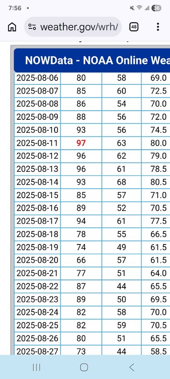
Absolutely correct. 5 days in a row in fact. Weirdly still ended up below normal. Concord...
-
Some models had a squall line, but in reality it remained hit or miss with backbuilding clusters and slow moving supercells. The low and mid level wind fields were nothing special, but it seemed like there was strong shear up at the anvil level preventing cold pool formation. The tops of the storm were being blown way to the SE. It being too humid for much evaporation (not to mention late at night) could also be part of it. I’m just happy I got lucky with a drought ending trainer locally when I wasn’t expecting much.
- Yesterday
-
Storms are firing a county or two south of me. And they’re probably going to stay down there most of the night.
-
I am changing my expectations for the Nino. It's a record Nino, and extremely east-based. This means that places like central Texas will experience normal autumn and winter rains. Which would be near zero. I'll be lucky to get an inch in drizzle by August 2027. If you happen to live in places like the Carolinas, Georgia, Florida, (he southern Gulf states excluding Texas, we are too far west for this one) southern plains states, Tenn, Kentucky, places like those, catastrophic flooding will reign supreme for months. Some places to the north will get shellacked with deep snow on top of the flooding. I am so jealous of Georgia and Alabama. You guys are gonna need arks. Big ones. It's never gonna stop raining. Don't like rain? Move to Austin. We'll be high and dry, especially in the 2027-2028 Mega Nina. And hot as hell.
-

Augdewst 2026: Summer's Last Stand
powderfreak replied to Prismshine Productions's topic in New England
Tornado Warning up here, huh. BULLETIN - EAS ACTIVATION REQUESTED Tornado Warning National Weather Service Burlington VT 741 PM EDT Mon Aug 10 2026 The National Weather Service in Burlington has issued a * Tornado Warning for... Northwestern Lamoille County in northwestern Vermont... West central Orleans County in northeastern Vermont... Central Franklin County in northwestern Vermont... * Until 815 PM EDT. * At 741 PM EDT, a severe thunderstorm capable of producing a tornado was located over Fairfield, moving east at 35 mph. HAZARD...Tornado and quarter size hail. SOURCE...Radar indicated rotation. IMPACT...Flying debris will be dangerous to those caught without shelter. Mobile homes will be damaged or destroyed. Damage to roofs, windows, and vehicles will occur. Tree damage is likely. * This dangerous storm will be near... Sheldon, Enosburg, Fairfield, Bakersfield, Fletcher, Waterville, Belvidere, and Cambridge around 745 PM EDT. Johnson, Montgomery, and Belvidere Center around 750 PM EDT. Lowell and Eden around 755 PM EDT. Hyde Park around 800 PM EDT. -
While I would never trade instant information for the old days it does make the world a little smaller. Back in the day if I wanted to know who opened for The Pretenders at the Orpheum in 1996 I would call my friend Bill. I never talk to Bill anymore...
-

Augdewst 2026: Summer's Last Stand
Go Kart Mozart replied to Prismshine Productions's topic in New England
Sweatpants and long-sleeve Ts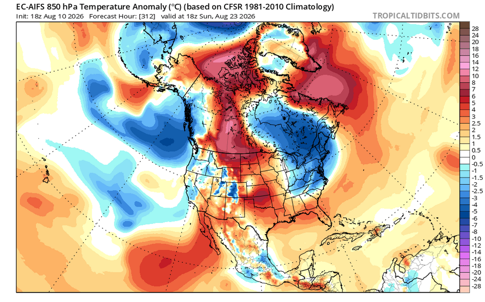
-
Good reason. Embrace the desert! And chase for your sanity. You are in a pretty good spot for the upcoming Nino winter where strong coastal lows are favored that will produce upslope in your area. Just hope it is cold enough lol.
-

2026-2027 Record-breaking El Nino
michsnowfreak replied to Stormchaserchuck1's topic in Weather Forecasting and Discussion
Maybe "triggered" was a poor word choice, although ive seen it used by some incorrectly to reference the cold/snow posters a lot too. The models are certainly colder/less warm than I was expecting for this strong nino. But im really more interested/worried about precip patterns. A part of me really likes the wetter look of a lot of models (even tho the brunt is east) and the idea of a juiced jet. But cant discount the overall tendency of drier in El ninos. -
And of course the line of storms is collapsing on cue. Not that it would have amounted to much, with it being a thin line and fast moving, but the quadrant of the RAH CWA from Raleigh, east to me, and north, cannot get jack doodly to fire for the past week. Yeah, there is no mesoscale focus and we're too far east for the piedmont trough cells to hit us and we're too far north for the sea breeze front. But with so much heat and moisture leading to instability, you'd think cells wouldn't just shrivel up and die every time.
-

Augdewst 2026: Summer's Last Stand
SJonesWX replied to Prismshine Productions's topic in New England
I had multiple 90+ days last august. it was nearly identical to July, at least in NH -
Not one of ya! Bitching ya want MORE rain. Here’s to ya getting your wish in the dark days.
-
Flooding may end up being the bigger headline around here if the timing doesn't play out right with the rounds of storms
-
Not once, have I had to get up early to shovel rain. Let alone clearing the vehicles. Who here owns the rainblower or even a rain shovel???
-
Earlysville got slammed this go around.... Tree and power line damage is pretty widespread....
-
Dark, gloomy, and dead. Fuckin vampire weather!








.thumb.jpg.ad3a2e31d30aff035044689b311a0540.jpg)

