All Activity
- Past hour
-

January 2026 regional war/obs/disco thread
ORH_wxman replied to Baroclinic Zone's topic in New England
Warming. Not warm. It gets pretty warm after 1/7 -

New Years Day 2026 - 1st snows of the new year possible
kdxken replied to Baroclinic Zone's topic in New England
Hmmm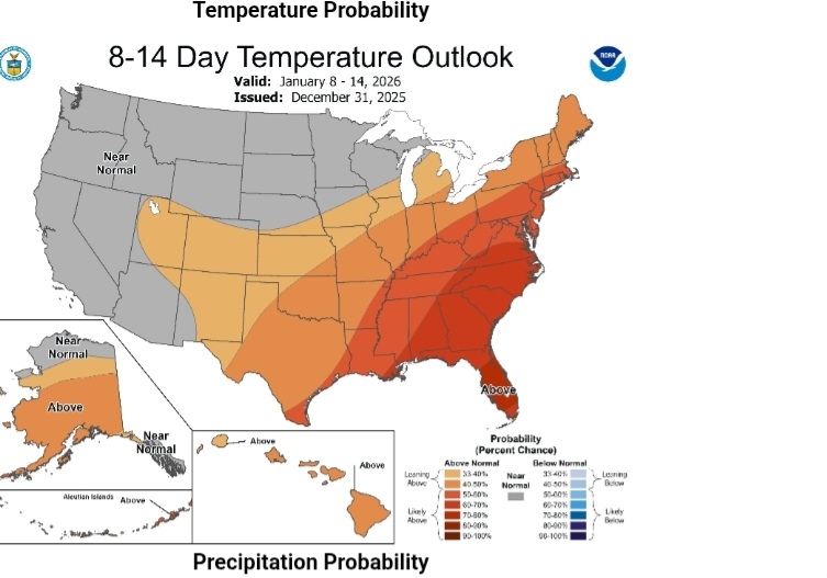
-
Jan 25 2000. Seen it happen hundreds of times here…thousands
-
New Years Day 2026 - 1st snows of the new year possible
kdxken replied to Baroclinic Zone's topic in New England
I'll say February. That's when we got that Blockbuster 4-in storm last year. -

Central PA Winter 25/26 Discussion and Obs
Blizzard of 93 replied to MAG5035's topic in Upstate New York/Pennsylvania
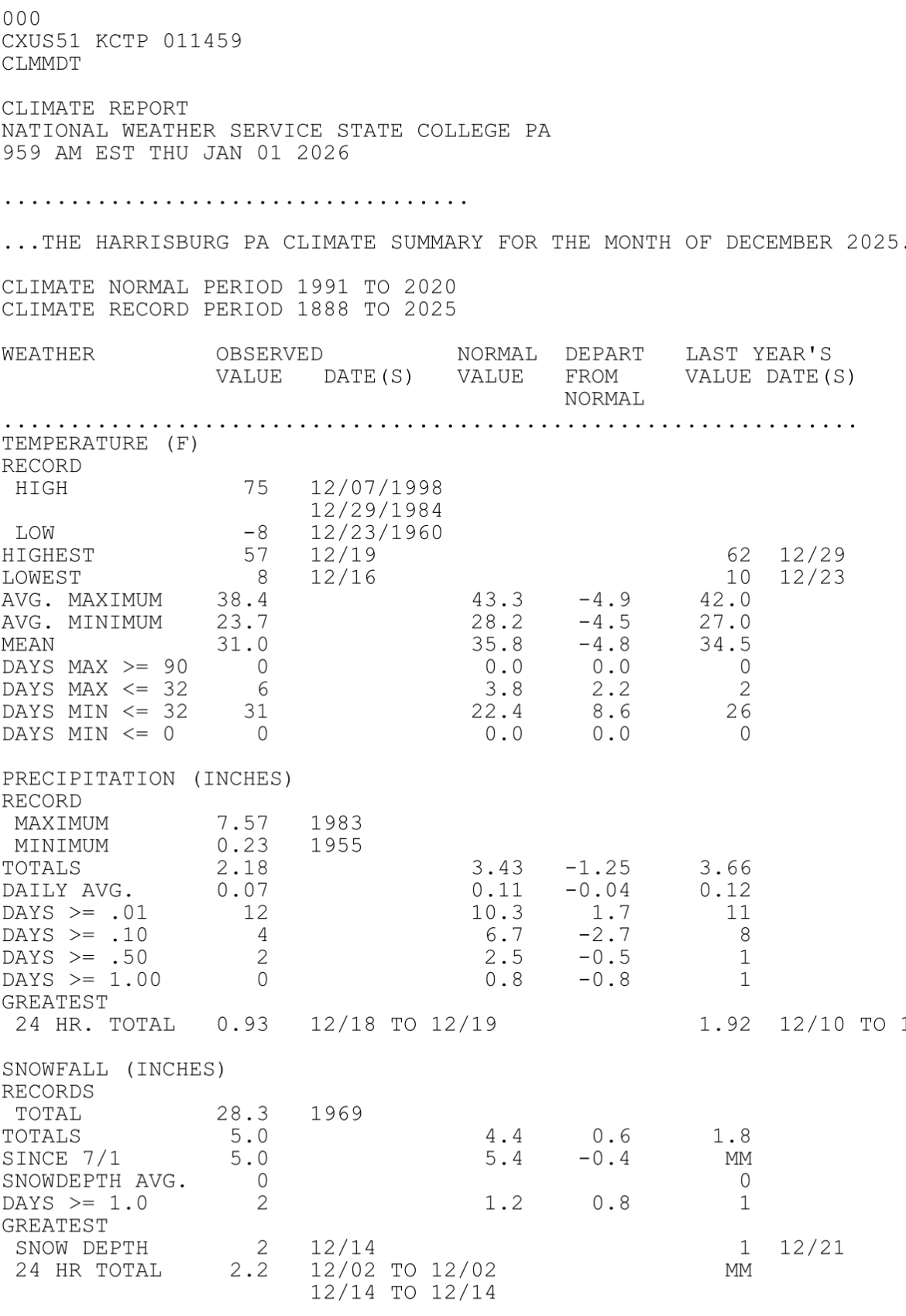
December is now in the books at MDT. -4.8 temperature departure 5.0” snow which is slightly above the 4.4 December average. Not a bad start to the Winter. Hopefully we have more chances to score snow as Winter continues.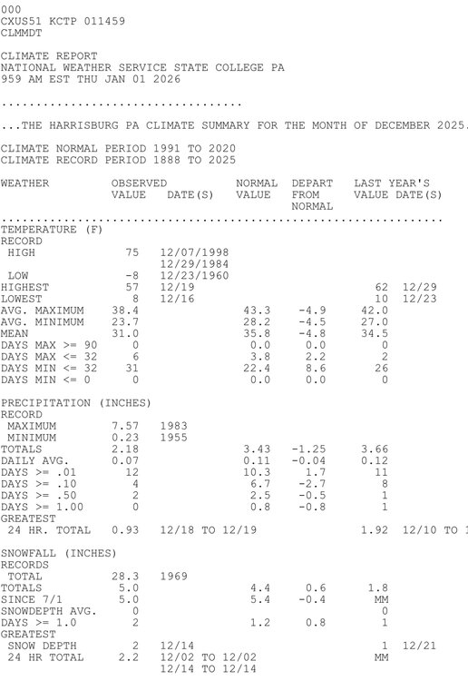
-
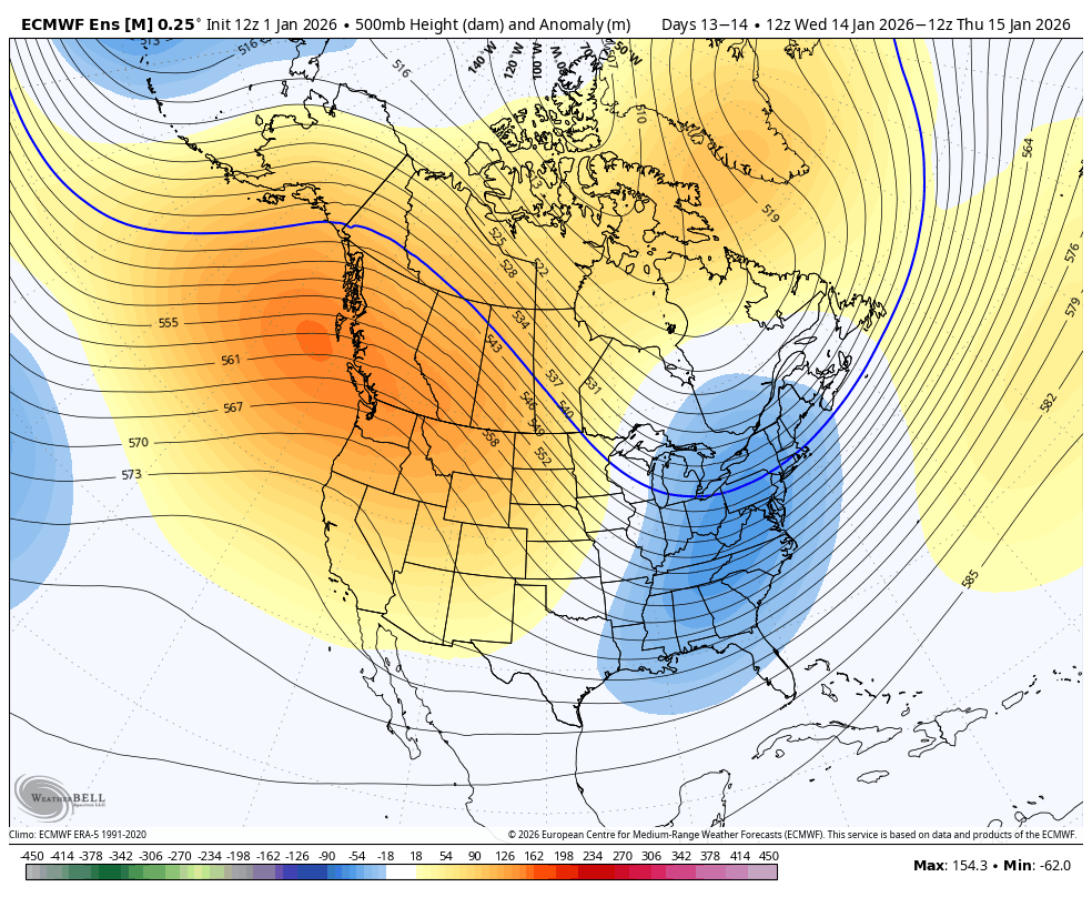
Like the op, the GEFS has been incrementally moving in the right direction at h5. 0z run compared to the most recent 18z run-
-
New Years Day 2026 - 1st snows of the new year possible
kdxken replied to Baroclinic Zone's topic in New England
It's possible. -
Clear. Windy. 15.9F
-
You must have 1994 on your mind!! Shades of @Bob Chill's total glaciation with a foot of ice!!
-
55 as the sun sets on this 1st day of 2026. .
-
GEFS is close enough to something to stay interested especially SE of DC
-
1/1: 0.1" T: 3.4"
-

January 2026 regional war/obs/disco thread
Damage In Tolland replied to Baroclinic Zone's topic in New England
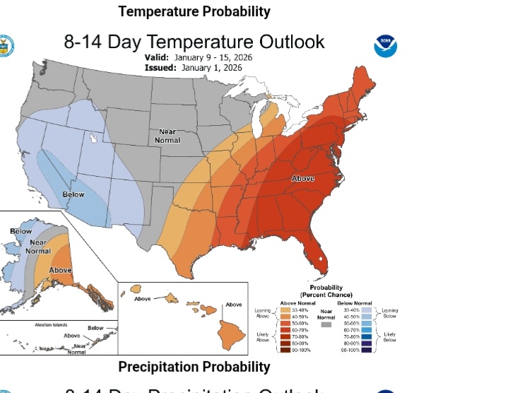
How are we warm the first 10 days of the month ? I mean beer? It’s in the teens and 20’s for highs thru Tuesday . That’s Jan 6th. Maybe after that a few milder days but to say the first week of Jan is warm when it’s WBN is simply wrong -

Winter cancelled/uncancelled banter 25/26
CPcantmeasuresnow replied to Rjay's topic in New York City Metro
Yes, in the next 14 days I have four forecast days above 40. I may fill up the pool. -

January 2026 regional war/obs/disco thread
dendrite replied to Baroclinic Zone's topic in New England
MAV mins for tonight. There’s actually a little WAA overnight too. I suppose it wouldn’t take much to decouple in the CRV after midnight if they can avoid clouds by then.
-

January 2026 regional war/obs/disco thread
brooklynwx99 replied to Baroclinic Zone's topic in New England
i think the main thing about Jan so far is that the potential colder start was predicated upon a highly anomalous block forming… now that it isn’t going to form, we’re going to warm up for the first 10 or so days of the month however, the changes in the Pacific have been well modeled between the 10-15th, and those are likely to occur… we should see a -EPO form, which will definitely help our chances, especially if bolstered by +PNA/-NAO like the EPS
-
I was surprised, too. We’ll see whether anything measurable is added in the climate entry.
-
Happy New Year! Please post your Jan obs as well as current/recent wx occurring anywhere. Regardless of what the rest of Jan has in store, I’m outside enjoying another stellar day thanks to Canada!
-
LGA is usually pretty reliable with measurements. They must not have bothered to measure. It seems unlikely they didn't get something measurable.
-
i am a weenie lol i need to hold onto ANY hope i can
-
Final Snowfall Totals from the Snow Squall: Bridgeport: Trace Islip: 0.4" New York City-Central Park: 0.5" New York City-JFK Airport: 0.4" New York City-LaGuardia Airport: Trace Newark: 0.7"
-
Lol I appreciate your optimism and usually I am optimistic too. But that low pressure near the outer banks is barely budging north. I hope the northern stream comes in hot and heavy, and perfectly timed. I'll be glad if I get a dusting.
-
January 2026 regional war/obs/disco thread
dendrite replied to Baroclinic Zone's topic in New England
Wind don’t care -
They still have value for guidance. Some runs/periods are better than others. At times they’ve been stellar while at other times they’ve been in the commode. Overall they’re the best that we have for the long range, which is very hard for models to forecast. But in this case, the medium range of the Euro has been in the commode with too cold apparently! Before this, the medium range of models had been too warm for that cold 3 week period and for 12/29-1/1.
-

January 2026 regional war/obs/disco thread
DavisStraight replied to Baroclinic Zone's topic in New England
Probably not accounting for radiational cooling and snow.