All Activity
- Past hour
-
Would be cool if we could get a repeat of those thunder snow squalls that we saw last year.
-

November 2025 general discussions and probable topic derailings ...
CoastalWx replied to Typhoon Tip's topic in New England
Don't see much EPS support. -

November 2025 general discussions and probable topic derailings ...
WinterWolf replied to Typhoon Tip's topic in New England
Give it another couple days at least…before we thread imo. -
BWI: 22.3 DCA: 16.7 IAD: 28.3 RIC: 9.6 SBY: 11.7
-
For official rain at my place, I have a cocorahs gauge. I always like to compare it to the station one.
-
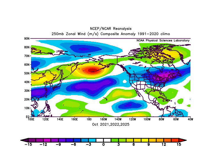
That big +WPO vortex is similar to October 2021 and 2022. It creates a steep gradient between the cold in Siberia and the record WPAC warm pool. So we get a very fast Pacific Jet as a result with frequent lows cutting through the Great Lakes.
-

Central PA Fall Discussions and Obs
Itstrainingtime replied to ChescoWx's topic in Upstate New York/Pennsylvania
Finally from MU: Due in large part to an unseasonably warm first week of the month, aggregate temps in #October2025 ended up slightly above average. Rainfall was near normal thanks to the "last-second save" on the 30th. -

Mid to long range discussion- 2025
WinstonSalemArlington replied to wncsnow's topic in Southeastern States
Euro weeklies -

November 2025 general discussions and probable topic derailings ...
Typhoon Tip replied to Typhoon Tip's topic in New England
It may be worth it to thread for that if it persists. There is some index support - -
(002).thumb.png.6e3d9d46bca5fe41aab7a74871dd8af8.png)
Central PA Fall Discussions and Obs
ChescoWx replied to ChescoWx's topic in Upstate New York/Pennsylvania
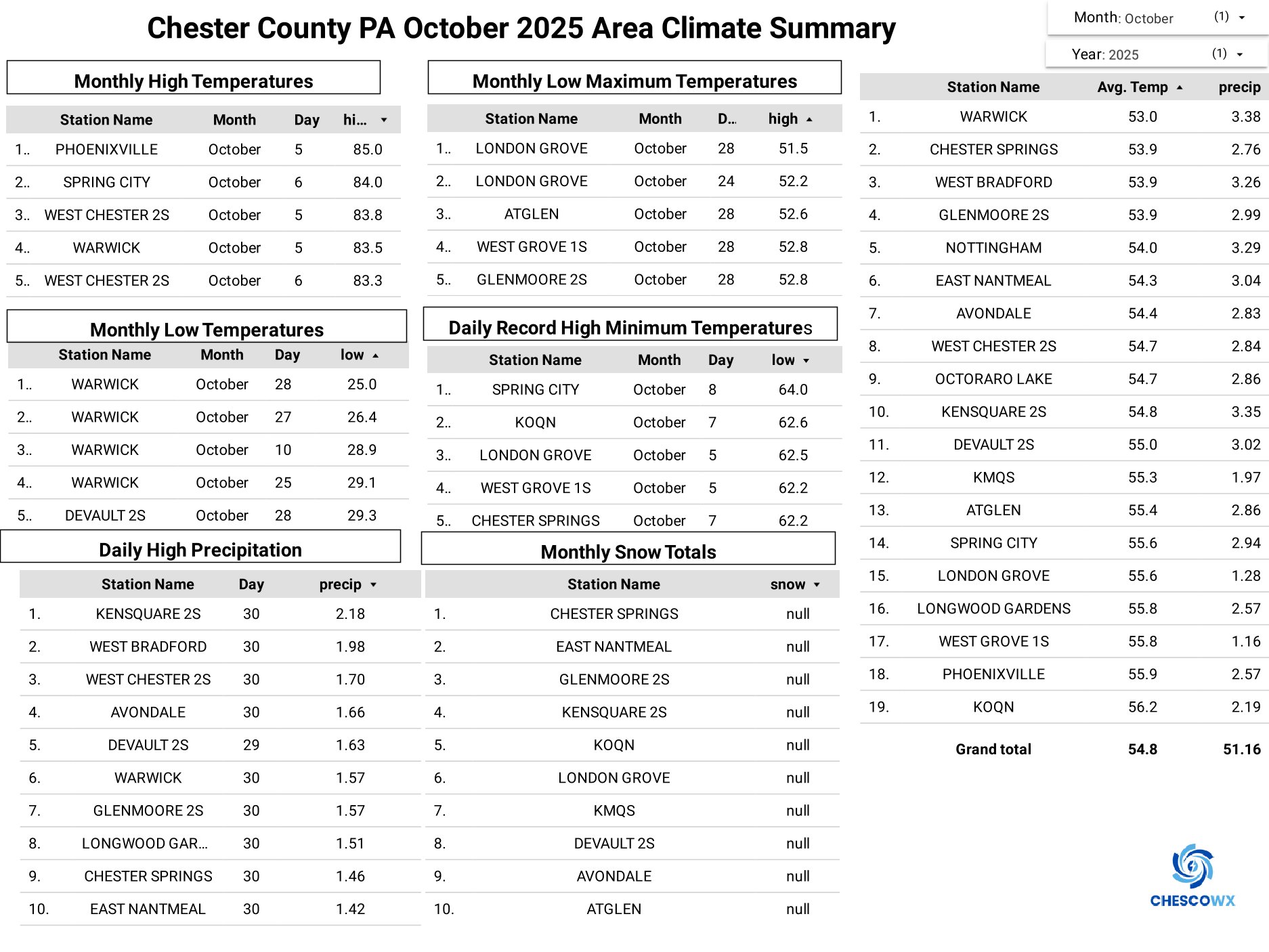
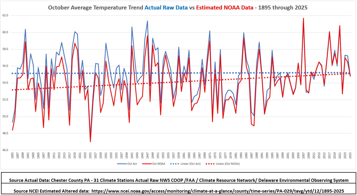
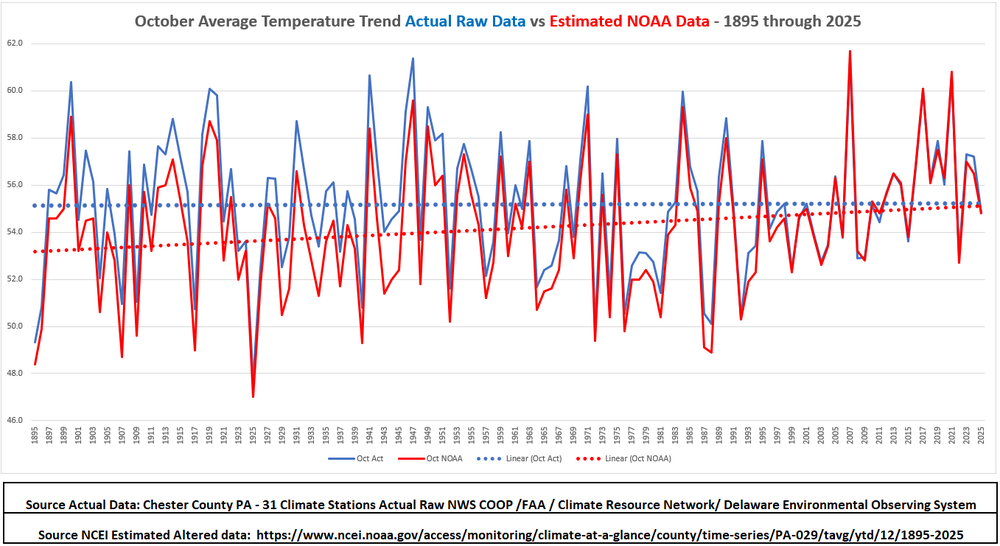
Here in Chester County PA October finished as our 5th below normal temperature month over the 1st 10 months of 2025, It was the 59th coldest October over the last 133 years of county climate records. Precipitation wise it was the 53rd driest October but much wetter than last October which was our driest October on record with many spots not recording any measurable rainfall at all. This October continues our trend of slightly cooling Octobers with climate records back to 1893. Below is the October average temperature trend lines and the overall Climate Summary Detail for October 2025.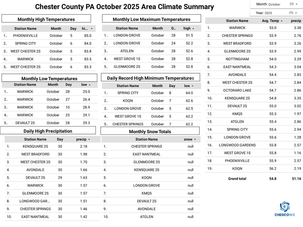
-
E PA/NJ/DE Autumn 2025 Obs/Discussion
ChescoWx replied to PhiEaglesfan712's topic in Philadelphia Region
Here in Chester County PA October finished as our 5th below normal temperature month over the 1st 10 months of 2025, It was the 59th coldest October over the last 133 years of county climate records. Precipitation wise it was the 53rd driest October but much wetter than last October which was our driest October on record with many spots not recording any measurable rainfall at all. This October continues our trend of slightly cooling Octobers with climate records back to 1893. Below is the October average temperature trend lines and the overall Climate Summary Detail for October 2025.
-
Central PA Fall Discussions and Obs
Itstrainingtime replied to ChescoWx's topic in Upstate New York/Pennsylvania
Sorry, the above posts are out of order. LOL Forecast has a ton of similarities to last year, including the forecast of a late December/early January cold snap that he nailed. -
Central PA Fall Discussions and Obs
Itstrainingtime replied to ChescoWx's topic in Upstate New York/Pennsylvania
Here you go, snow lovers! The moment you've been waiting for is here: my 2025-2026 Winter Outlook! Three primary winter-season influences will be a weak La Niña, strongly-negative Pacific Decadal Oscillation (PDO) & weak stratospheric #PolarVortex (SPV). The weak SPV should allow Arctic air to plunge into the Central/Eastern States at times, mainly before mid-Jan & perhaps again in late Feb or Mar. Analogs suggest the coldest/snowiest part of winter could be around the holidays due to high-latitude (NAO/AO) blocking. Despite plenty of mild days during the 2nd half of the season, odds of a #WhiteChristmas are the highest in years. From Dec-Feb, aggregate temps should be slightly above normal (0 to +2°F). "All-rain" & "changeover" events will be common after mid-Jan with more "all-snow" events beforehand. -
November 2025 general discussions and probable topic derailings ...
CoastalWx replied to Typhoon Tip's topic in New England
Ha that’s funny, I mentioned that yesterday in this specific thread too. I think I’d like to see a little bit more support for that though… But it’s a deep trough with some shortwaves rounding the bend so need to watch maybe for at least first flakes, if not, maybe minor stuff and some interior areas. -
 Heiny is back !
 -
Mid to long range discussion- 2025
WinstonSalemArlington replied to wncsnow's topic in Southeastern States
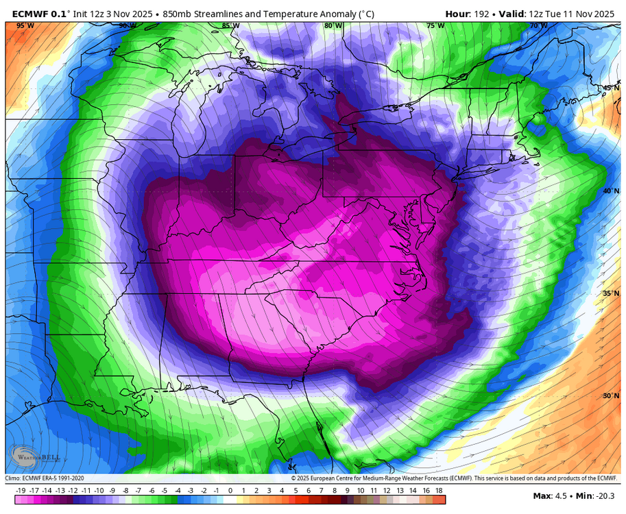
GFS joins the cold train -
Central PA Fall Discussions and Obs
Itstrainingtime replied to ChescoWx's topic in Upstate New York/Pennsylvania
MU: -

2025-2026 ENSO
Stormchaserchuck1 replied to 40/70 Benchmark's topic in Weather Forecasting and Discussion
I haven't been talking about it as much because it's been near neutral.. the May-Sept total N. Atlantic SST indicator for Winter (DJFM) NAO came in at +0.08. It has a normal standard deviation of 0.54, so that makes it 50% likely to have a Winter NAO -0.46 to +0.64. -

November 2025 general discussions and probable topic derailings ...
Heisy replied to Typhoon Tip's topic in New England
Pretty strong ULL solution on 12z euro for day 7-9 . -
BWI: 20.2 DCA: 14.2 IAD: 20.8 RIC: 12.2 Tie Breaker SBY: 10.2
-
November 2025 general discussions and probable topic derailings ...
Typhoon Tip replied to Typhoon Tip's topic in New England
12z Euro's hinting at a NJ modeler in a week. In fact, if it were not for some lead wave interference it'd likely take off. As is, it's the first regional lower elevation inclusive chance to snow. I was mentioning that 10-13th period over in the winter outlook thread just this morning. -
Scientific sales is where I have bought a lot of my weather equipment. They are cheaper than Davis. I use my vantage vue for rain and temperature and wind readings are separate about 30 ft . in the air.
-
If you want to trust the Euro snow map a week out (one can't), those of us in Orange County will have some shoveling to do.
-
Barney’s coming to town early next week: Hello, boys and girls! That’s me coming to an E US location near you!

-
Bwi: 13.4" DCA : 9.6" IAD : 15.2" RIC :5.4" Tie Breaker SBY:3.8"