All Activity
- Past hour
-

Central PA Winter 25/26 Discussion and Obs
pawatch replied to MAG5035's topic in Upstate New York/Pennsylvania
That’s a good point you make.That explains why such a high temperature. Because once that front come through it was all downhill. -
We melt
-
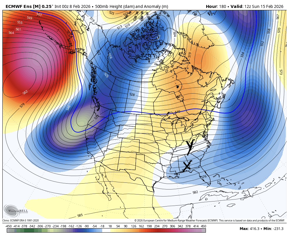
 Oz guidance across the board didn’t eject enough energy and trended more suppressive with the Atlantic look. Bad combo. Result is this. We need x to be where y is and stronger but that’s redundant because for it to be where y is it would have to be stronger.
-
Doesn’t look like much going forward.
-
Winter Storm Threat *Technical* Discussion. No Op Run PBP or Snow maps
psuhoffman replied to CAPE's topic in Mid Atlantic
Oz guidance across the board didn’t eject enough energy and trended more suppressive with the Atlantic look. Bad combo. Result is this. We need x to be where y is and stronger but that’s redundant because for it to be where y is it would have to be stronger.
-

Feb 10-11 Mid Week Minor Event - Ride the hot hand?
CoastalWx replied to HoarfrostHubb's topic in New England
Yeah maybe an inch or two. -
They've been doing this in the fantasy range for days and nothing has come into view. I have zero trust in anything they show after day 4-5. Yeah I'm over it. If there's no more snowstorms coming then there's no need for this.
-

Winter Storm Threat *Technical* Discussion. No Op Run PBP or Snow maps
CAPE replied to CAPE's topic in Mid Atlantic
0z EPS- The primary energy ejecting from the SW does pop a low along the Gulf coast and moves off the NC coast. It gets some precip into the MA on the mean. Cold looks marginal but interior areas at elevation might be in a good spot should precip make it there. Just beyond that it looks mild with a temporary ridge over the east. Then we shall see about the potential around the 20th or so. -

February 2026 OBS & Discussion
Freezing Drizzle replied to Stormlover74's topic in New York City Metro
Light to moderate, cold rains can build a snowpack, rainfall wicks in and re-freezes. A great example of that was 2000-2021. -
This thread got weird. Chuck said it couldn’t snow this week because the pacific pattern would make it too warm. The problem we have right now is a combination of guidance trending towards a weaker wave that gets absorbed by the approaching larger scale pacific trough and a more suppressive Atlantic which squashes any weak energy that ejects ahead. If anything it’s the opposite problem of what Chuck was worried about. If that Atlantic low backed off some and a healthier wave ejects it looks cold enough until Monday. After that it starts getting problematic fast but the window over PD weekend is there IF a strong enough wave ejects and right now it looks like it might not Mitch we can’t trust anything bit if you want there to be a shot you want good solutions snowing up within the scope of all the guidance.
-
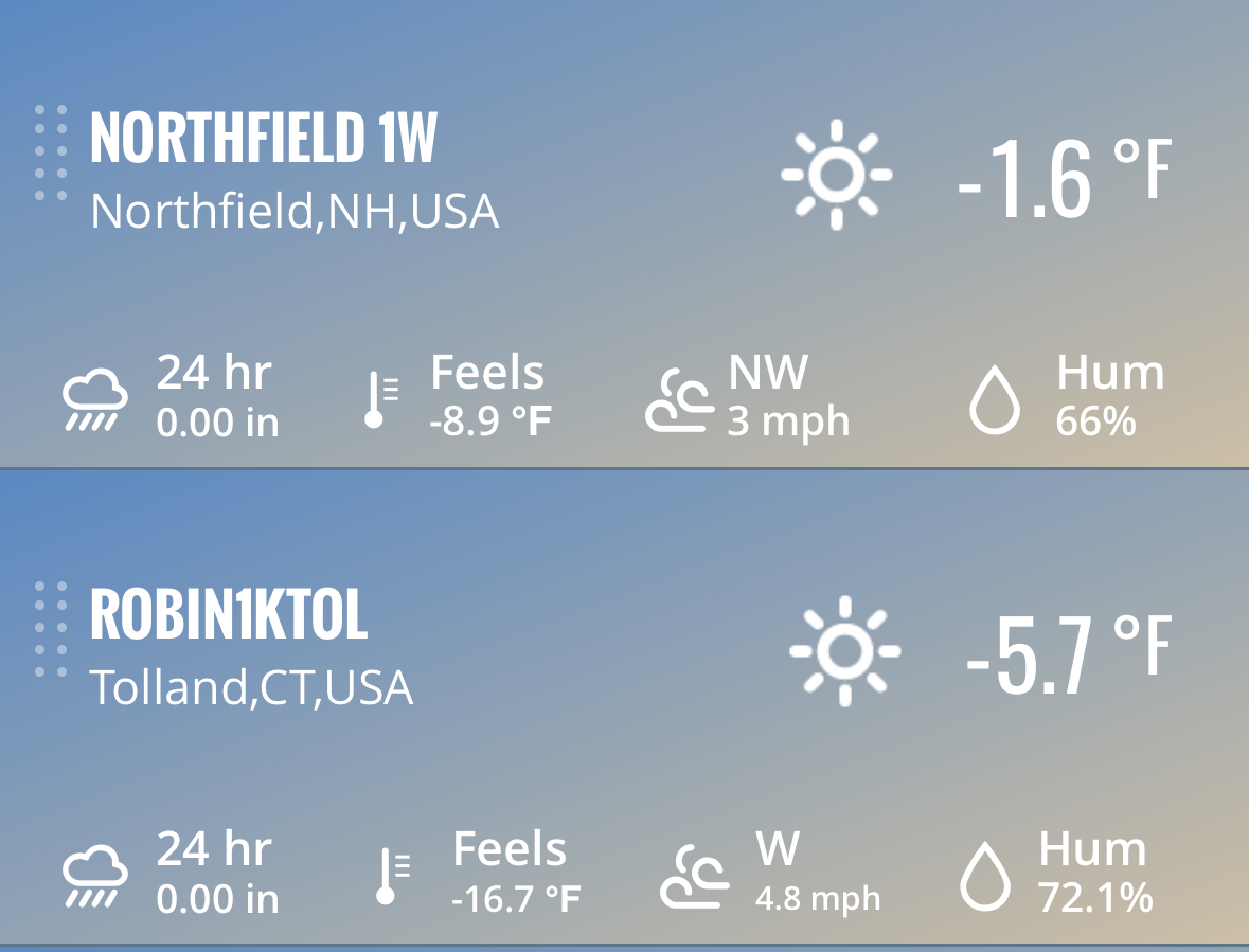
 -5F here with a nasty wind.
 -
 LGA 5 JFK 3 NYC 3 I think I said 4-5° given how low the core of the cold was coming in. That would flirt with daily records on some days, but not on 2/8 because of 1963’s sub zero.
 -
Feb 10-11 Mid Week Minor Event - Ride the hot hand?
HoarfrostHubb replied to HoarfrostHubb's topic in New England
Favors northern areas. Still some time but very week -
February 2026 OBS & Discussion
Freezing Drizzle replied to Stormlover74's topic in New York City Metro
Like a football score lol -
 -9.6/-12.6
 -
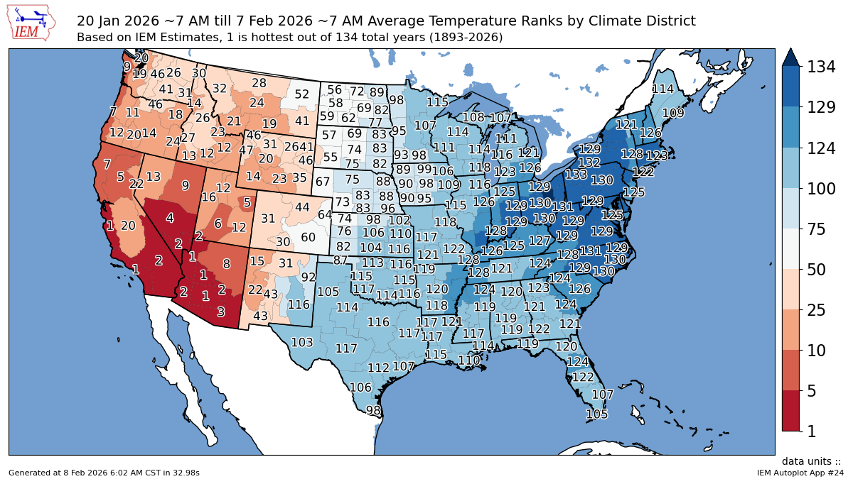
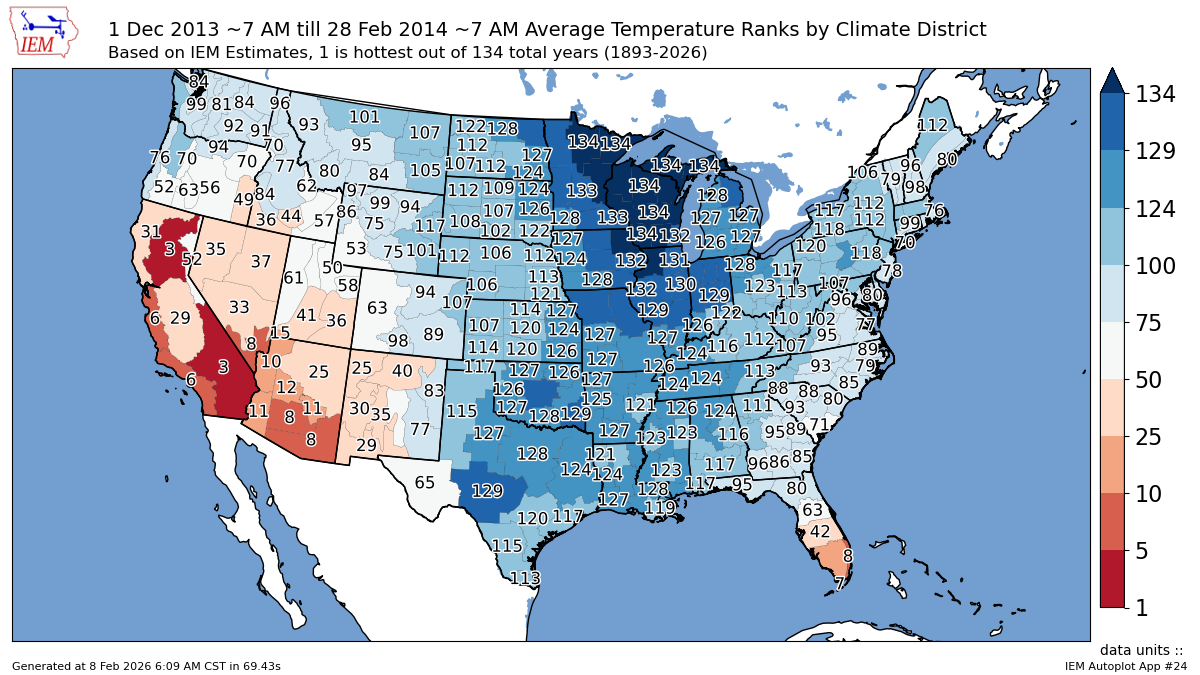
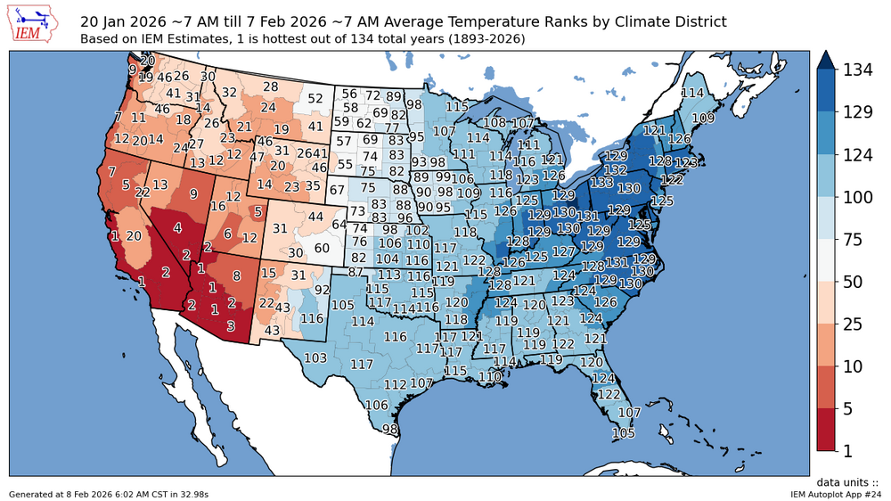
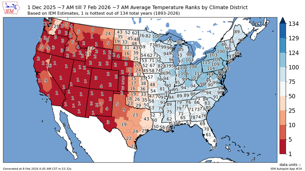
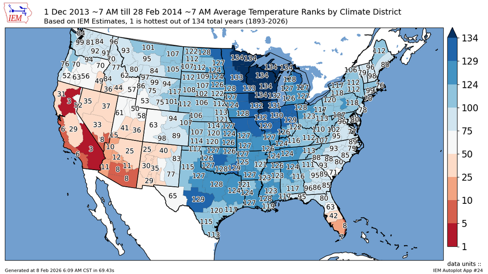
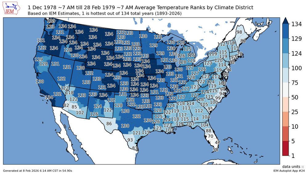
December and January finished around the 7th warmest for the CONUS. So the warmth out West has been much more impressive than the cold in the East. The shorter duration last 2 to 3 weeks had top 5 and top 10 cold for climate districts in the East for January 20th to February 7th. But since the start of the winter the climate districts and the larger regions haven’t been nearly as cold. With how warm our winters have become since 2015-2016, it makes this winter feel much colder since people quickly normalize their recent 3-7 year climate. Right before the big global and national temperature jump in 2015-2016, the Great Lakes and Upper Midwest regions were able to sustain a top 10 cold pattern for the entire winter of 2013-2014. But that cold pool was less expansive than the late 1970s so nationally we couldn’t rank in the top 10 or even top 20. It finished 33rd coldest for the CONUS. We can see how the record warmth wasn’t present in the West that winter. Prior to the multiple temperature increases since the early 1980s, the entire CONUS had its last top 10 coldest winters from coast to coast with no extreme warmth anywhere in the CONUS in the late 1970s. With 1978-1979 ranking as the coldest winter since 1895 for the CONUS. https://bsky.app/profile/climatologist49.bsky.social/post/3me3dxzzakc23 social Follow The Dec-Jan period was the 7th warmest for the Contiguous U.S. since 1940. 21.1% had the warmest Dec-Jan during that period. 0.0% had the coldest Dec-Jan; 0.0% had the 2nd coldest, 0.0% had the 3rd coldest, .... all the way thru the 13th coldest. 9:32 PM · Feb 4, 2026
-
Columbia 8 at sunrise imby.
-

Central PA Winter 25/26 Discussion and Obs
Mount Joy Snowman replied to MAG5035's topic in Upstate New York/Pennsylvania
Temps didn’t plummet until well after midnight. I brought this up the other day, how the ‘ol midnight high was really going to be a doozy yesterday. Stinks because it doesn’t at all tell the story of the day we had but that’s how the cookie crumbles sometimes. -
 -2.. not bad on par with Jan 2023
 -
February 2026 OBS & Discussion
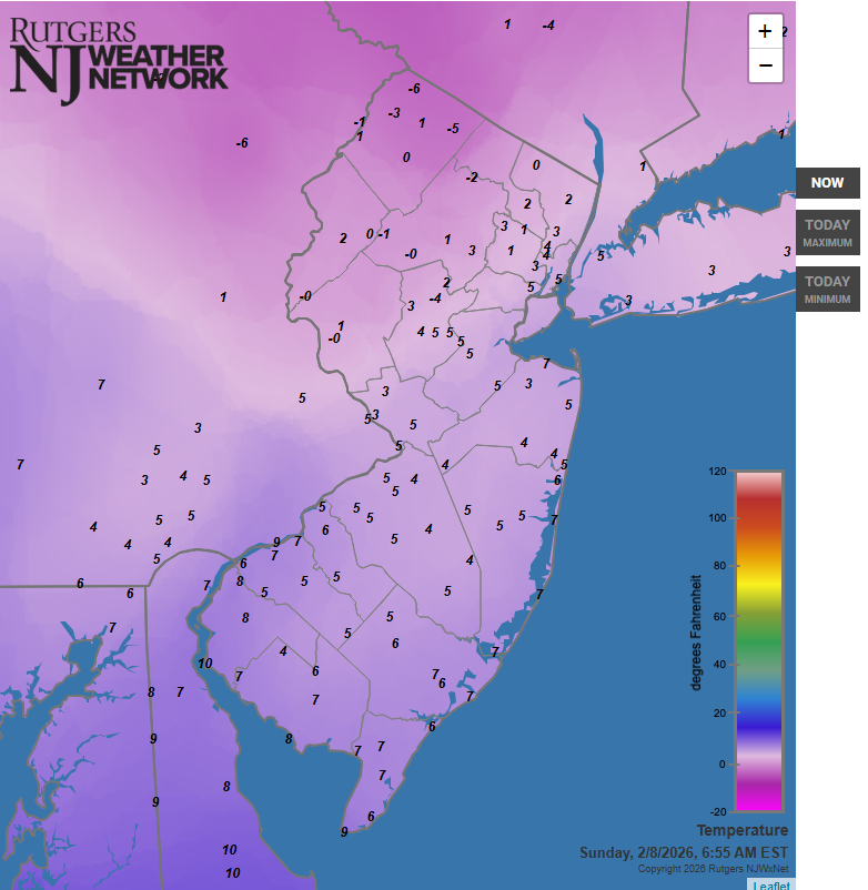
Freezing Drizzle replied to Stormlover74's topic in New York City Metro
Good morning. 6:55 am.
-
-2.1 will probably do it Defeated by Ditty
-
 Looking ahead toward the late week into weekend period, additional perturbations in the flow keep low-end probabilities (15 to 25 percent) for precipitation in the forecast. As temperatures cool through the week, some of this would be comprised of a rain/snow mix. The overall surface pattern does show high pressure building in from the Great Lakes while a wavy frontal zone arcs along the southern U.S. Uncertainty is unusually high toward the end of the period given the complexities of the flow to resolve. Deterministic models continue to vary wildly from run to run, but this is not surprising at this point. It does remain a period to monitor ahead.
 -

Friday February 6 FROPA / WINDEX small event
Great Snow 1717 replied to HoarfrostHubb's topic in New England
Correct...all anyone needs to do is look at the snowfall reports from that area.. -
Low was 2. Meh.
-
Was at 1 briefly here now sitting at 2