All Activity
- Past hour
-
SOI Dashboard Latest Southern Oscillation Index values SOI values for 14 Jul, 2026 Average SOI for last 30 days -23.53 Average SOI for last 90 days -17.62 Daily contribution to SOI calculation -36.56 Monthly average SOI values Apr -9.88 May -13.22 Jun -22.69 Date Tahiti (hPa) Darwin (hPa) Daily Contribution 30 day Av. SOI 90 day Av. SOI 14 Jul 2026 1011.36 1016.35 -36.56 -23.53 -17.62 13 Jul 2026 1010.44 1015.10 -34.53 -23.20 -17.20 12 Jul 2026 1009.89 1015.20 -38.53 -23.21 -16.92 11 Jul 2026 1011.77 1015.80 -30.66 -23.06 -16.66 10 Jul 2026 1013.16 1015.45 -19.94 -22.84 -16.52 9 Jul 2026 1011.59 1014.45 -23.45 -22.68 -16.60 8 Jul 2026 1008.90 1015.20 -44.63 -22.32 -16.71 7 Jul 2026 1009.02 1015.35 -44.81 -21.68 -16.58 6 Jul 2026 1011.31 1015.45 -31.33 -21.34 -16.28 5 Jul 2026 1010.44 1015.25 -35.46 -21.21 -16.03 4 Jul 2026 1010.84 1015.20 -32.69 -21.02 -15.72 3 Jul 2026 1012.59 1014.20 -15.76 -21.11 -15.44 2 Jul 2026 1012.97 1013.80 -10.96 -21.75 -15.38 1 Jul 2026 1013.06 1012.90 -4.86 -22.28 -15.31 30 Jun 2026 1012.34 1013.05 -14.06 -22.69 -15.35 29 Jun 2026 1012.32 1013.40 -16.66 -22.71 -15.25 28 Jun 2026 1012.24 1013.25 -16.17 -23.03 -15.20 27 Jun 2026 1011.64 1014.05 -26.01 -23.61 -15.12 26 Jun 2026 1012.48 1015.20 -28.19 -23.51 -14.93 25 Jun 2026 1012.84 1015.15 -25.31 -22.78 -14.75 24 Jun 2026 1011.76 1015.15 -32.90 -22.11 -14.60 23 Jun 2026 1011.31 1015.45 -38.17 -21.86 -14.34 22 Jun 2026 1012.65 1016.30 -34.73 -21.65 -14.02 21 Jun 2026 1014.99 1017.00 -23.20 -21.10 -13.63 20 Jun 2026 1015.10 1016.25 -17.15 -20.98 -13.17 19 Jun 2026 1014.90 1014.50 -6.26 -21.36 -12.93 18 Jun 2026 1015.57 1014.80 -3.66 -21.66 -12.87 17 Jun 2026 1016.03 1015.35 -4.29 -21.73 -12.88 16 Jun 2026 1015.83 1014.90 -2.53 -21.79 -12.82 15 Jun 2026 1014.24 1014.70 -12.30 -22.62 -12.75
-
 That’s why it’s helpful to ask questions lol
 -
MCS/Derecho chances on the rise for this weekend in the northwest flow around the heat dome- winds in those things can reach 100 mph ...........last one to hit central NJ was Labor Day 1998
-
 Yes it does...
 -
If an EF3 hits a forest and nobody is around, does it make a sound?
-
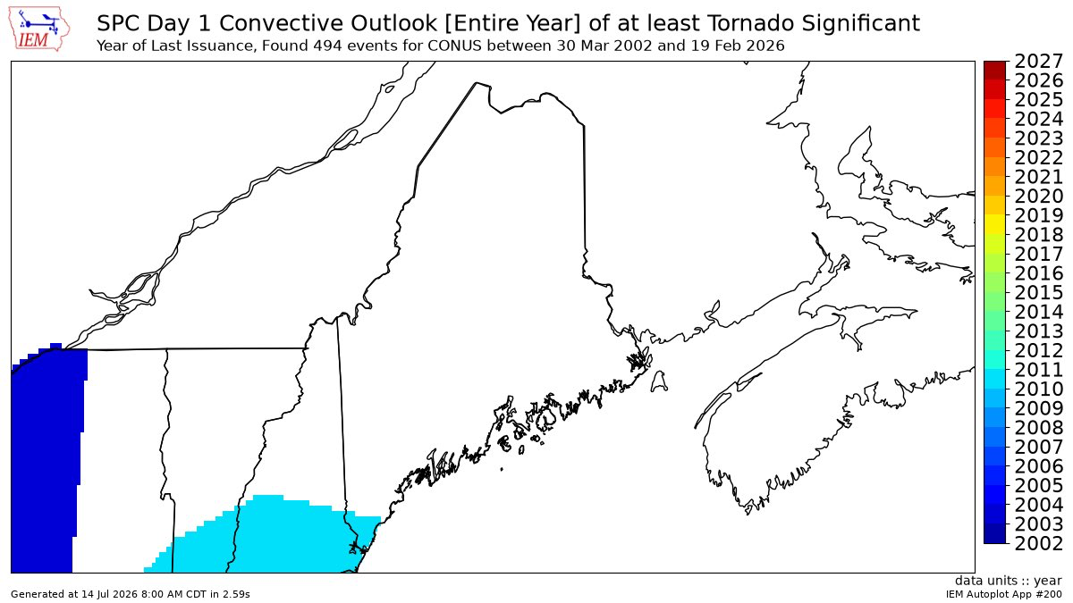
 The 10% hatching is not unprecedented in New England but has not occurred in that region before.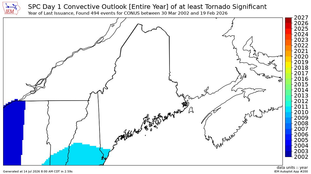
-
 77/64 pretty meh considering today was supposed to be oppressive
 -

2026-2027 Super El Nino
mitchnick replied to Stormchaserchuck1's topic in Weather Forecasting and Discussion
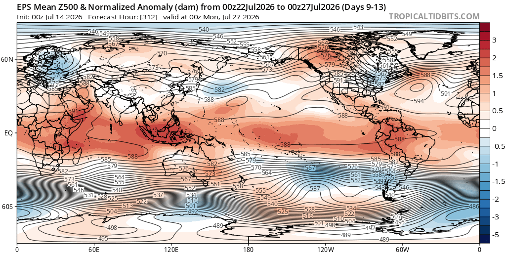
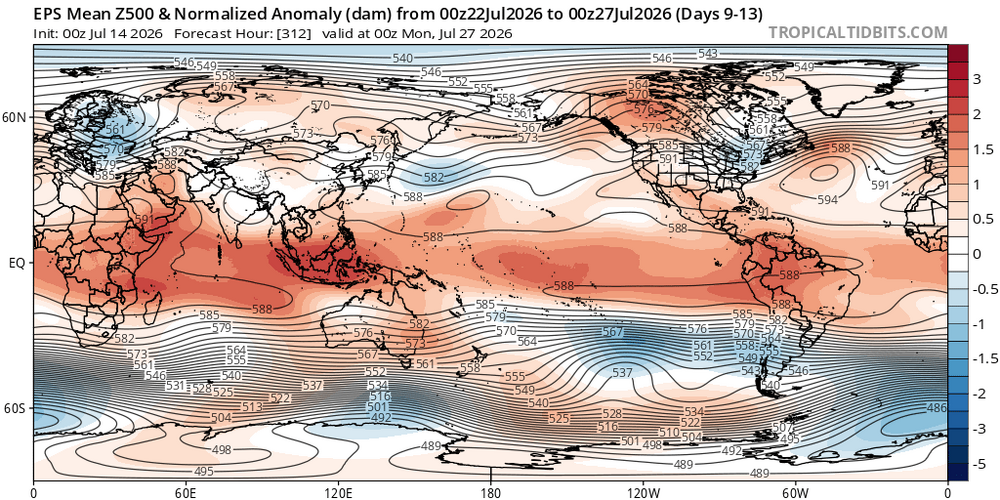
5 day average https://www.tropicaltidbits.com/analysis/models/?model=eps®ion=us&pkg=z500aMean&runtime=2026071400&fh=264 -
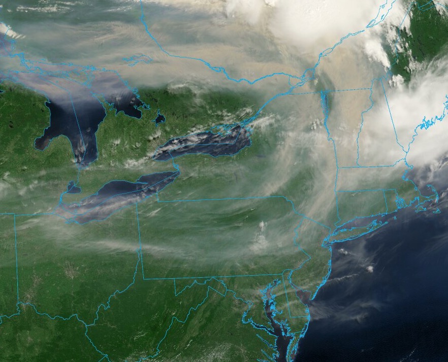
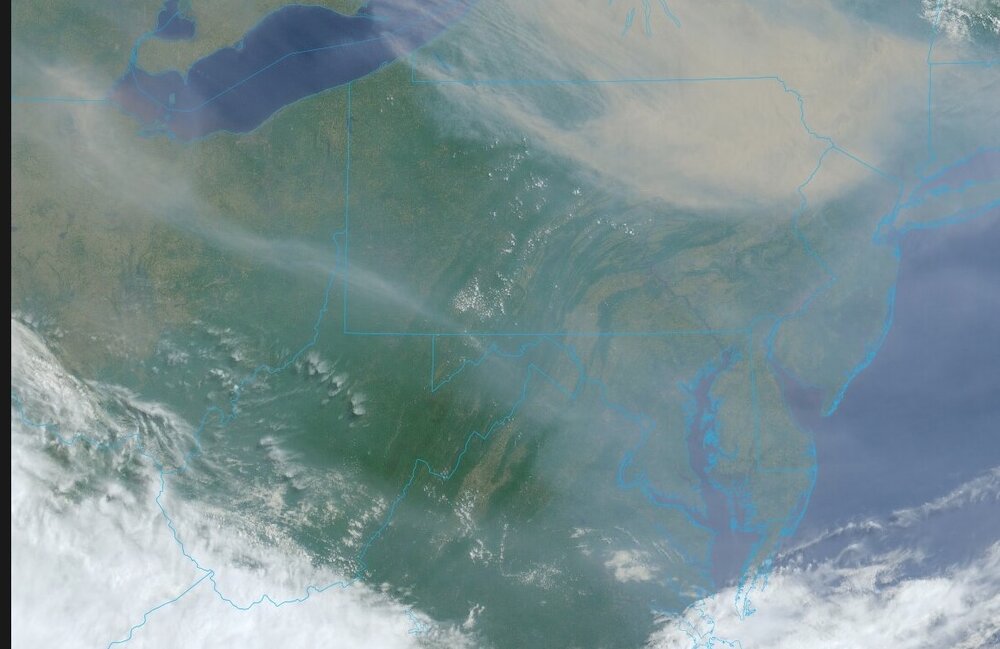
 As of 11:15am an extremely thick smoke layer has moved overhead. I can look up at the sun and see it very clearly. No cirrus but an erry yellow glow like NYC had several years ago. I have never seen a smoke layer as dense as this while ground visibility is over 25 miles 75/64
 -
Nope. Of course the whole week (and most of summer to this point) is dry too, which is so annoying. We will make the best of it, but rain would just add to the stress levels. New ICON is pretty rainy
-
2026-2027 Super El Nino
mitchnick replied to Stormchaserchuck1's topic in Weather Forecasting and Discussion
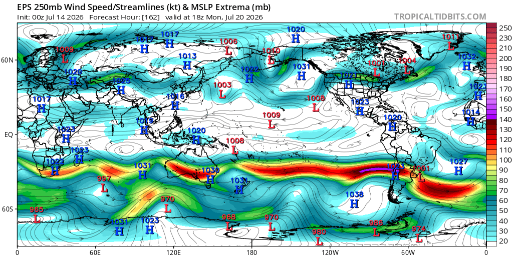
Eps says it's coming to a N. Hemisphere near you. https://www.tropicaltidbits.com/analysis/models/?model=eps®ion=us&pkg=z500a&runtime=2026071400&fh=210 -
Never easy is it? That will be us next year. Would be a mess here with rain
-
 About as useless as today’s event then. An EF3 will probably rip up a few million trees and no one will know.
 -
 Scientist tackles James Joyceian stream of consciousness. Fascinating!
 -
Fingers crossed for you. Been there done that. It does suck.
-
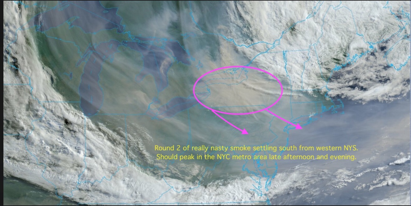
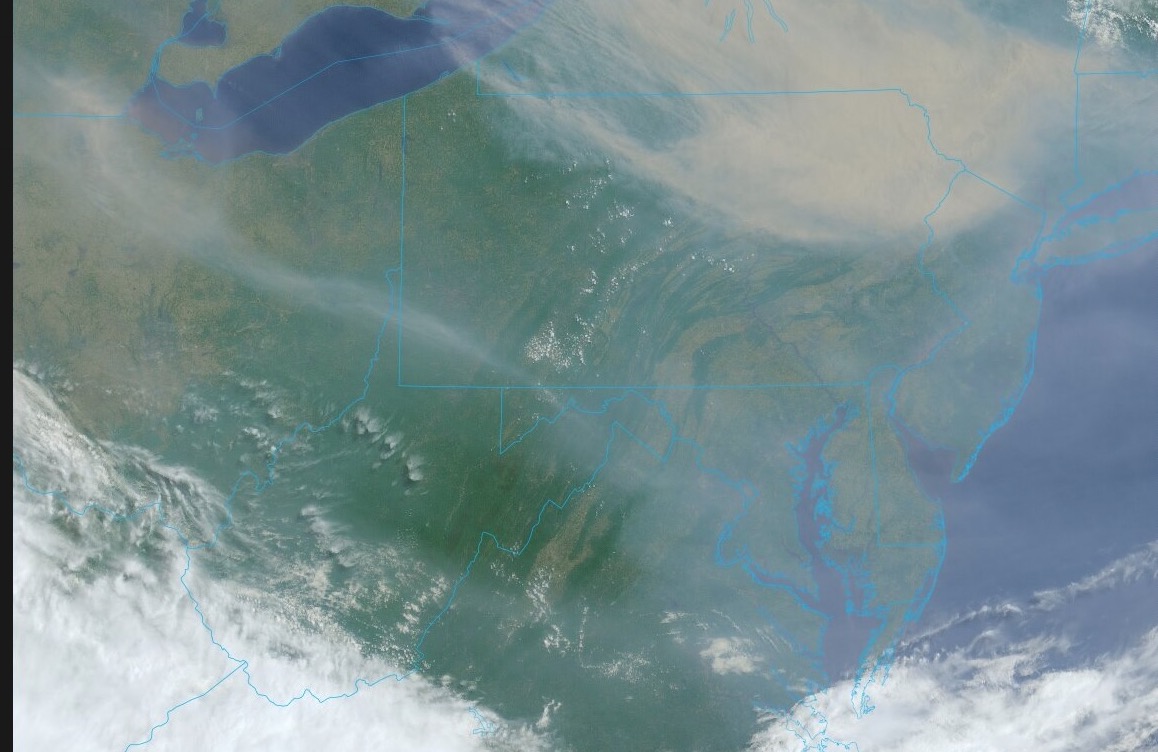
Current satellite of smoke plume. Surprised more air quality alerts are not being issued, at least for Upstate NY and New England?
-
Will take the morning or the night. My girls' grad party on Sat and will have nearly 100 people over. I'll have 2 large tents, but rain would still suck. ugh
-
 It's actually normal for nocturnally driven MCS to decay after sun rise. Granted, that one did have a weak perturbation in the flow that helped ignite it way up there overnight, but once that happened... part and parcel to the vitality of the S part of the M C S ( mesoscale convective system) is what's known as "radiative cloud top cooling" ...this factor destabilizes the region over the MCS at mid and high levels; a smaller quotient of what is needed for the overall instability/machinery for the embedded cyclonic cycling to keep going. Sun rises; that factor disappears. poof. Anyway not sure what happened last month but just sayn'
 -
 The same can be said anywhere really when it comes to lapse rates. There was a setup in the midwest a few months back which was flagged with higher tornado probabilities and potential for strong and long-tracked tornadoes but that never materialized...and it was a setup in which they had relatively weak lapse rates. It truly is hard to get a full fledged higher end severe weather outbreak without the present of steep lapse rates. The lapse rates here that day were horrible...but I recall they weren't modeled to be as bad as what actually transpired.
 -
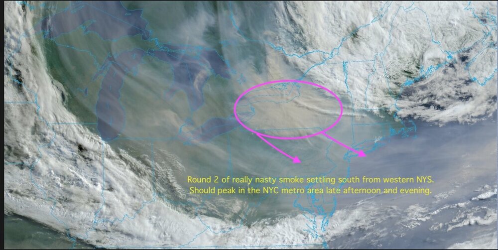
Will be hard to beat that smoke plume from June 2023. That was something else. I remember driving along Rt. 80 in my area and smoke was at ground level blowing across the road. Visibility was low and the air smelled of burning wood. If you didn't know better you would have thought it was from a local forest fire, not something from up in Canada.
-
Wow
-

2026-2027 Super El Nino
bluewave replied to Stormchaserchuck1's topic in Weather Forecasting and Discussion
It would be interesting to see what is causing the delayed response this time in the mid-latitudes. Even by MJJ in 2023 with all that mid-latitude SST warmth and strong -PDO +AMO, the pattern was strongly El Niño in the mid-latitudes. While summer correlations are weaker with the larger El Niño grouping including weak and moderate, the developing super El Niño subset has been fairly strong. At least so far we are seeing something new from this one for MJJ. -
Looking like the rain could be here during the morning Saturday.
-

2026-2027 Super El Nino
LakePaste25 replied to Stormchaserchuck1's topic in Weather Forecasting and Discussion
yeah there’s a solid mid latitude response happening in Chile. Nice mid latitude cell off the coast, extended pac/STJ and they’re getting blasted with rain and mountain snow. That’s what’s convincing me right now.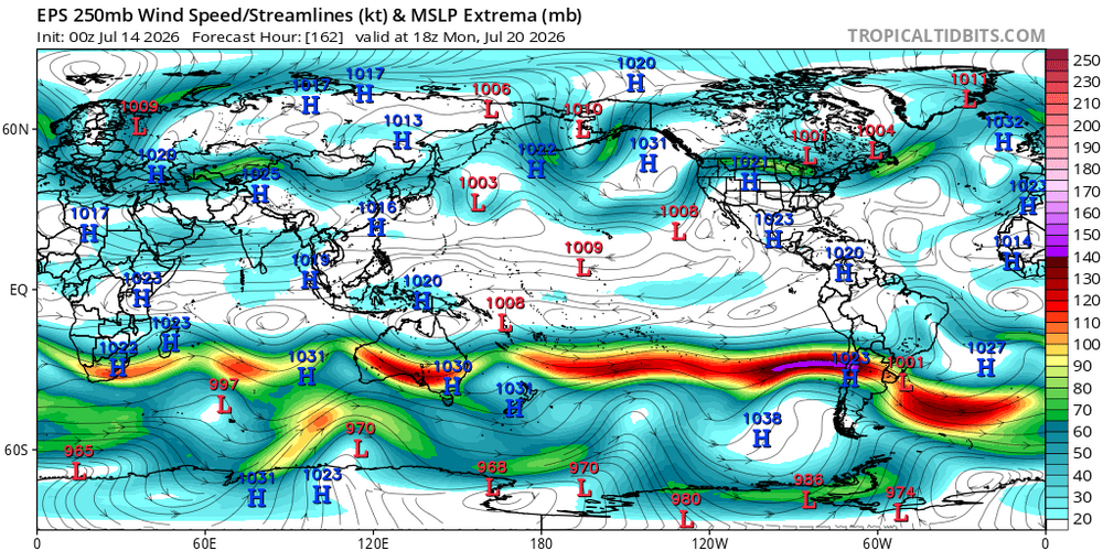
-
Cloudy and some smoke around.. sun is trying to come out but cant.. maybe only upper 80s here today?