All Activity
- Past hour
-
.18" at home. In North Conway NH for the week. Beautiful area. Hit Mt Washington on Monday before the clouds rolled in. Breathtaking views.
-

September 2025 OBS-Discussion centered NYC subforum
psv88 replied to wdrag's topic in New York City Metro
0.05 -
 Agreed! The balancing act between systems will be fascinating to watch
 -

2025-2026 ENSO
donsutherland1 replied to 40/70 Benchmark's topic in Weather Forecasting and Discussion
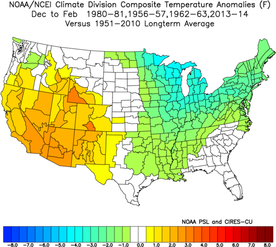
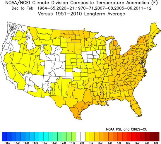
With respect to the EPO, the swing from the minimum value during the first half of September to the maximum value (so far) for the second half of September is the fourth largest on record. All of the prior 10 biggest such cases occurred during the evolution toward either La Niña or Neutral-Cool ENSO winters. The composite temperature anomalies for the Neutral-Cool ENSO Winters: The composite temperature anomalies for the Neutral-Cool ENSO Winters: However, warmth is not a slam dunk for the Northeast/Great Lakes. Winters 1964-65 and 1970-71 were cold in the Northeast, Great Lakes, and Northern Plains. Winters 2007-08 and 2020-2021 were cold in the Central Plains. Finally, the sample size is limited to 10 extreme EPO cases.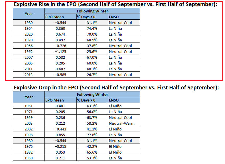
-
Let’s get RI’s rain total to match Dendy’s total since June.
-
Well, I guess this is good weather to get work done. Interesting to see DeepMind mentioned in the LWX disco. Neural nets and GenAI are legit…those computing resources, though.
-
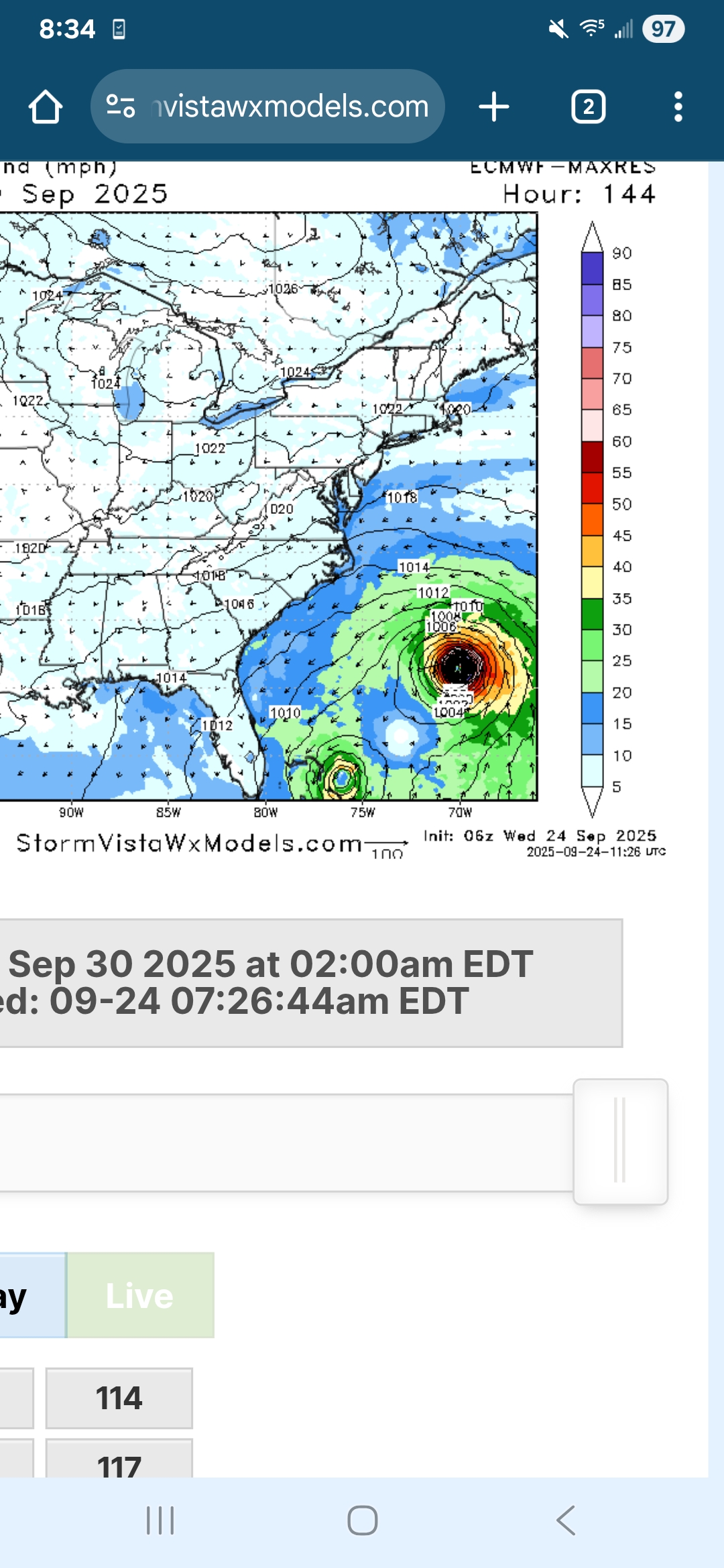
 It does seem like a landfall is becoming somewhat unlikely for 94L because it gets pulled back out to sea by 93L. Meanwhile 93L is too far out to have a decent chance of being pulled into the coast by 94L. The most likely landfall scenario is a combination of 93L being weaker than expected and more spacing between the systems allowing 94L to be pulled into the coast by the ULL
 -
1-2” from wrn RI to New Bedford.
-

-
-
Recon might start sampling the environment today per NHC. This is a really complicated setup with the two systems so close. 00z EPS
-
It's been moving around
-
6z EURO is completely different from 0z.. hr 144 one is left in the Bahamas and the other is heading NW.. but would probably be eventually pushed out?
-
Man RI and the South coast is getting slammed right now..if we could just keep that heading north a little ways and we’d all get a good soaking!
-
 Eastern Caribbean Sea (AL94): A tropical wave over the northeastern Caribbean Sea is producing disorganized showers and thunderstorms. This wave is expected to move west-northwestward at 15 to 20 mph, spreading heavy rainfall and gusty winds into Puerto Rico and the Virgin Islands today, and across the Dominican Republic beginning tonight. The system is then expected to slow down and turn northwestward when it reaches the southwestern Atlantic late this week. Environmental conditions are forecast to be more conducive for development in a few days, and a tropical depression is likely to form when the disturbance is in the vicinity of the Bahamas. Interests in the Virgin Islands, Puerto Rico, the Dominican Republic, the Turks and Caicos Islands, and the Bahamas should monitor the progress of this system. An Air Force Hurricane Hunter Aircraft is scheduled to perform a system survey this afternoon to gather data from the surrounding environment, if necessary. * Formation chance through 48 hours...low...30 percent. * Formation chance through 7 days...high...80 percent.
 -
Good chance this becomes a TD later today or tonight. Despite westerly shear the organizational trend continues.
-
Euro has to be testing the physical limitations for how close 2 tropical cyclones can be to one another.
-
It was always CT.
-
Picked up 1.02" of rain from yesterdays system. Millersville well over 2" of rain.
-

September 2025 OBS-Discussion centered NYC subforum
wdrag replied to wdrag's topic in New York City Metro
Continuing review for a possible thread 6PM today for 22z/24-12z/26.Pprior posts by Bluewave have it right. 1-3 iso 5 possible. Getting complex. The closed low OH Valley will happen and looking like we get something addition from it 18z Sat-18z Sun. Thereafter, uncertainty greater but as noted previously, tropics get involved with the east coast trough-W Atcl ridge. At a minimum, I would not be fishing in the coastal waters next Tue-Wed. Even if the tropics peel east-shunted s, the large cool high settling into New England sets up the potential for an early season modest gale on the CW s of LI and e of NJ, assisted by the larger BL temp lapse rate. Offline most of the day. 0.24 here in this part of nw NJ last evening. - Today
-
Nothing overnight, 0.21" yesterday, 0.71" for September, and 1.24" for August. Seems positively lush compared to some nearby posters. Currently, light to moderate rain under the beam, sitting in the porch, drinking coffee, and enjoying the dews while they last.
-

September 2025 OBS-Discussion centered NYC subforum
SACRUS replied to wdrag's topic in New York City Metro
Records: Highs: EWR: 92 (2017) NYC: 91 (2017) LGA: 91 (2017) JFK 92 (2017) Lows: EWR: 40 (1950) NYC: 40 (1963) LGA; 44 (1974) JFK: 40 (1963) Historical: 1869: Heavy rain dumps nearly 10 inches on the White Earth Reservation, MN. (Ref. AccWeather Weather History) 1888: The earliest frost of record hit the southern states, covering South Carolina, Georgia and, northern Florida. (Ref. AccWeather Weather History) 1926 - The temperature at Yellowstone Park dipped to nine degrees below zero. It was the coldest reading of record in the U.S. during September. Severe freezes were widespread over the northwestern U.S. causing great crop destruction. In Washington State, Spokane County experienced their earliest snow of record. Harney Branch Experiment Station in Oregon reported a temperature of 2 degrees above zero to establish a state record for the month of September. (David Ludlum) (The Weather Channel) 1926: The temperature at Yellowstone Park drops to 9 degrees below zero, making it the coldest September reading ever recorded in the US. 1939: A thunderstorm on this day dropped 6.45 inches in six hours at Indio, CA. This rainfall preceded “El Cordonazo” or “The Lash of St. Francis”, an actual tropical storm. For the entire storm, which started on this day and ended on the 26th, four inches of rain fell across the deserts and mountains as a dying tropical cyclone moved across Baja California into southwestern Arizona. This storm was the second tropical cyclone to impact California during this month. A strong El Niño may have contributed to the activity. The tropical storm produced 50 mph winds over the ocean and estimated seas of 40 feet. September rain records were set in Los Angeles with 5.66 inches and 11.6 inches at Mt. Wilson. 45 people died from sinking boats, and harbors were damaged. Total damage was estimated at $2 million. Californians were unprepared and were alerted to their vulnerability to tropical storms. In response, the weather bureau established a forecast office for Southern California, which began operations in February of 1940. 1950 - A smoke pall from western Canada forest fires covered much of the eastern U.S. Daylight was reduced to nighttime darkness in parts of the Northeast. The color of the sun varied from pink to purple, blue, or lavendar. Yellow to grey-tan was common. (24th-30th) (The Weather Channel) 1956: Hurricane Flossy made landfall near Destin, Florida as a Category 1 storm. 1972 - Lightning struck a man near Waldport, OR, a young man who it so happens was carrying thirty-five pieces of dynamite. (The Weather Channel) 1975: Remnants of Hurricane Eloise merge with a frontal system over Northeast, resulting in tremendous flooding. (Ref. AccWeather Weather History) 1984: Behind a strong cold front, Bismarck, ND had a record early season snowfall of 5 inches, their heaviest September snowfall. Along with the snow came record cold temperatures across parts of the northern Rockies. Billings, MT recorded their coldest September temperature of 22° followed by an afternoon high of just 31°. Other daily record lows included: Sheridan, WY: 13° and Casper, WY: 22°. Ahead of the front, along with dramatically warmer temperatures, by as much as 40 degrees plus, upper level dynamics were in place for severe weather. Crawford and Vernon Counties in Wisconsin reported baseball sized hail and 3 inch diameter hail was reported in La Crosse County, Wisconsin with this same cluster of storms. (Ref. Wilson Wx. History) 1986: An F2 tornado, unusually strong for one in California, touched down just southeast of Vina on this day and traveled two miles through an agricultural area. A mobile home was destroyed, injuring a 22-year-old occupant. Eleven other buildings were damaged or demolished, and 50 acres of walnut orchards were flattened. 1987 - The first full day of autumn proved to be a pleasant one for much of the nation, with sunny skies and mild temperatures. Thunderstorms again formed over Florida and the southwestern deserts, and also formed along a cold front in the northeastern U.S. A storm spotter at Earp CA sighted a couple of funnel clouds, one on the California side of the state line, and the other on the Arizona side. (The National Weather Summary) (Storm Data) 1988 - Thunderstorms developing along a stationary front produced large hail and damaging winds in the southeastern U.S., with reports of severe weather most numerous in North Carolina. Golf ball size hail was reported at Tick Creek and a number of other locations in North Carolina. (National Weather Summary) (Storm Data) 1989 - Forty-seven cities between the Rockies and the Appalachians reported record low temperatures for the date. Lows of 38 degrees at Abilene TX, 34 degrees at Jackson KY, and 36 degrees at Midland TX established records for the month of September. The low of 36 degrees at Midland smashed their previous record for the date by thirteen degrees. Fayetteville AR and Springfield MO reported their earliest freeze of record. Thunderstorms produced torrential rains in northeastern Florida. Jacksonville was deluged with 11.40 inches of rain, and flash flooding resulted in two deaths. (The National Weather Summary) (Storm Data) 2001: A weak, F0 tornado passed in the sight of the Washington Monument. Soon after, an F3 tornado struck College Park, Maryland. 2001: It was just 13 days after the 9/11 terrorist attack when the Emergency Action Notification System sounded in Washington, DC. Many people immediately thought the alert was for another attack, but it was actually for a tornado warning. The dramatic severe weather statement from the National Weather Service at Sterling, VA was that a tornado had been sighted near the Pentagon. (Ref. Wilson Wx. History) 2005 - Early in the morning, major Hurricane Rita came ashore near the Texas/Louisiana border 2005: Early on the morning of September 24, 2005, Major Hurricane Rita came ashore near the Texas/Louisiana border. -
September 2025 OBS-Discussion centered NYC subforum
SACRUS replied to wdrag's topic in New York City Metro
70 / 69 cloudy. Cloudy / warm - humid - Storms / shower , rain later into Thu late AM with 1 - 3 inches locally. Clearing out later Thu and a warm Friday - back into the 80s for most. The weekend looks dry Sat and most of Sunday but clouds could be sticking around both days. Watch the tropics 9/30 - 10/2. Overall warm with ridge 10/2 and beyond. -
Almost fun then OTS. Let's get that further north. It's been a long time since we've had any fun weather. Definitely something to watch.
-
Only 0.07" in gauge this morning, sure seemed like more, we had about 4 separate periods when it rained. Quite muggy and foggy outside. Low was 60.0, which although warm did not break the 63.8 degree 'warm minimum' set just last year.