All Activity
- Past hour
-
Another hilarious post from you.
-
For the storm on the 18-19th. It's 9 days out so I'm not worried right now about thermal profiles or rain snow lines. At the time I'm just glad models are showing the storm. I mean come on folks do any of us really wanna be in the bullseye 200+hours out??? Lol I know I don't because EVERY time I been in the bullseye 200 hours out I've NEVER capitalized
-

January 2026 regional war/obs/disco thread
dendrite replied to Baroclinic Zone's topic in New England
Finally a break up here with sun and mild temps.
-

Central PA Winter 25/26 Discussion and Obs
Superstorm replied to MAG5035's topic in Upstate New York/Pennsylvania
That is becoming a dream map! . -
Yep! The chase in on...now prepare for all the ups and downs that come every 6 hours for the next 5-8 days.
-
Who’s having fun?!
-
Not sure what made storm #2 cut this time but either way we track on!
-

January 2026 regional war/obs/disco thread
TauntonBlizzard2013 replied to Baroclinic Zone's topic in New England
Late March spring type feel today. Love it. -
Definitely. But it's definitely sizeable. A 3-5 day stretch would be a break in the cold. Some models don't really show any true arctic air til 1/20 so could be a 2 week stretch of average to above average.
-
Next Sunday would be a great day to spend at wisp
-
Been very warm this week. Around low 50s past few days, and looks like we continue with the 40s until mid-late next week. The models rushed the pattern change back to cold. Still warm and mild for the foreseeable future. Thursday's storm threat has essentially dissipated (not for the south though) but trough seems to be too positively tilted to get it up to the coast. The follow up next weekend is too warm on the Euro and is in fantasy range anyway. Nothing to get excited about aside from the cold air returning mid week next week
-

January 2026 regional war/obs/disco thread
Damage In Tolland replied to Baroclinic Zone's topic in New England
It still does -
-

January 2026 regional war/obs/disco thread
RUNNAWAYICEBERG replied to Baroclinic Zone's topic in New England
Yup, it’s coming…deep winter ahead. -
The EURO has some odd convective snow showers scattered around that gives areas that get them a couple inches. Then has a miller A second system that has the heaviest snow in the East but some snow back to just west of Nashville. As Jax notes, very much for entertainment purposes here but whatever the models are seeing the last 24 hours seems to be universally producing something.
-
Mountains get smoked from system 2 mostly
.thumb.png.ebfad13136e5feedadae7c370ce77755.png)
-

January 2026 regional war/obs/disco thread
ORH_wxman replied to Baroclinic Zone's topic in New England
I think the most important takeaway from the 12z suite is that the longwave ridge is onshore out west or right on the coast and it has a couple pulses up and down…when you have that longwave setup, you’re putting yourself in the firing range so you’re going to get some legit chances with even a little bit of wiggle room. That’s why we’re seeing hits on different models that all look a slightly different with the shortwave evolution. But they all produce something because the longwave pattern wants to put a storm system near the east coast. Hopefully we don’t see that longwave look degrade as we get closer. -
Key takeaway=favorable
-
Sorry to hear this about your mom also,prayers for you and your fam
-
Almost never get all three models on the same page unless inside day 3 maybe. Like for once can they all agree? Grrr
-
I’ve been interested in that aspect of this for sure, especially over the holiday weekend. Great timing for the ski resorts if that played out - but verbatim that’s a legit setup for upslope with the trough and energy.
-
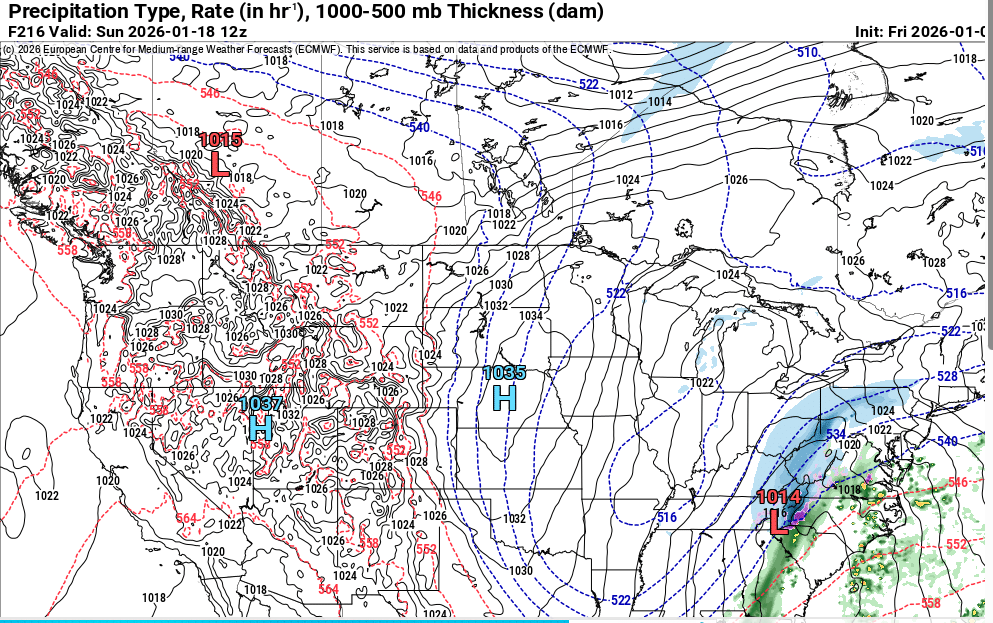
Euro also has the system on the 18th for East TN at least.
-
Yeah the 2nd storm ends up being to warm with rain. But still plenty of potential.
-
Admittedly jumped the gun but our 500mb look was great at this range
-

January 2026 Medium/Long Range Discussion
NorthArlington101 replied to snowfan's topic in Mid Atlantic
With it being a three-day weekend I've 100% got my eye on a chase if needed. Would rather stay put, ofc


.png.966b5f9701e3c9cf0171e3d915447ef9.png)


