All Activity
- Past hour
-

Central PA Fall Discussions and Obs
mahantango#1 replied to ChescoWx's topic in Upstate New York/Pennsylvania
Yes it is, talked to several people and their sick of this wind. -

2025-2026 ENSO
brooklynwx99 replied to 40/70 Benchmark's topic in Weather Forecasting and Discussion
also, anything before Dec 10 is gravy for 80% of NE/MA posters on this board. couldn't care less if it takes a few more days to get things going -
 Oh my God that has to be saved and used repeatedly this winter
 -
2025-2026 ENSO
brooklynwx99 replied to 40/70 Benchmark's topic in Weather Forecasting and Discussion
models often rush the progression of cold air eastward in -EPO patterns. i would say after the 5th is when snow risks increase for many in the Northeast in the same vein, i don't think much has really changed in terms of the overall progression. MJO is moving along, the SPV will become very weak and increase the shot at a -NAO spell, and we should see a BN to solidly BN December also, when you have a -WPO/-EPO (and likely a -NAO at some point), it is really, really difficult to have a truly bad period since there's so much cold air displaced into Canada and the CONUS -
 I didn't @ him at least. That would be dangerous.
 -

November 2025 general discussions and probable topic derailings ...
WinterWolf replied to Typhoon Tip's topic in New England
Maybe for the heaviest…but I’d say mid December through mid March for good chances. -

November 2025 general discussions and probable topic derailings ...
dryslot replied to Typhoon Tip's topic in New England
You just did............ -
Lol, not bad. Please, I hope no one tells Great Snow 1717 about this technology.
-
That’s honestly nearly impossible to predict with much confidence. But I’d lean toward at least a slightly warmer than avg Dec overall, especially this far south, due to the expected mild start.
-
 LMAO. We tried to tell Scoots
 -

2025-2026 ENSO
donsutherland1 replied to 40/70 Benchmark's topic in Weather Forecasting and Discussion
Latest PNA forecast for the closing days of November. This is why one shouldn't expect a sudden rush of cold into the East, even as colder air should be building in Canada and the western U.S.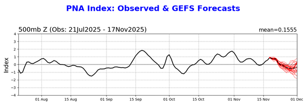
-
Are you thinking that south of the M/D line will see a warmer than average December, or will it be balanced out by a colder end?
-

November 2025 general discussions and probable topic derailings ...
alex replied to Typhoon Tip's topic in New England
-
November 2025 general discussions and probable topic derailings ...
alex replied to Typhoon Tip's topic in New England
Forecast said snow ending by 10 and it got much heavier right around then lol -
Another issue is how warm Canada has been especially since May 2023. The coldest temperatures for both NYC and Saranac Lake during the 2020s occurred back on 2-4-23. While it was one the warmest winters on record across the Northeast, there was still a decent cold pool near Hudson Bay in February available for that brief Arctic outbreak. That was the only time during the 2020s that Saranac Lake dropped to -33° and NYC to 3°. Data for February 4, 2023 through February 4, 2023 Click column heading to sort ascending, click again to sort descending. DANNEMORA COOP -39 HIGHMARKET 2W COOP -35 Saranac Lake Area ThreadEx -33 SARANAC LAKE ADIRONDACK REGIONAL AP WBAN -33 WATERTOWN INTERNATIONAL AIRPORT WBAN -33 GOUVERNEUR 3 NW COOP -31 THERESA 4NW COOP -29 LAKE PLACID 2 S COOP -29 COLTON 2 N COOP -29 MORRISVILLE 6 SW COOP -28 MASSENA INTL AP WBAN -28 Newcomb Area ThreadEx -27 BOONVILLE 4 SSW COOP -27 NEWCOMB COOP -27 WATERTOWN COOP -27 LOWVILLE COOP -26 MALONE COOP -26 INDIAN LAKE 2SW COOP -25 GLOVERSVILLE 7NW (PECK LAKE) COOP -24 Glens Falls Area ThreadEx -24 GLENS FALLS/FLOYD BENNETT MEMORIAL AIRPORT WBAN -24 SCHROON LAKE NEW YORK RAWS -23 TRENTON FALLS COOP -23 Plattsburgh Area ThreadEx -22 PLATTSBURGH INTERNATIONAL AIRPORT WBAN -22 SHERBURNE NEW YORK RAWS -20 CONKLINGVILLE DAM COOP -20 OGDENSBURG 4 NE COOP -20 SHERBURNE COOP -19 BUSKIRK COOP -19 ROME GRIFFISS AIRFIELD WBAN -18 SARATOGA SPRINGS 4 SW COOP -17 MECKLENBURG 4SW COOP -17 COOPERSTOWN COOP -16 MEXICO 2SW COOP -16 WHITEHALL COOP -16 LANSING MANOR COOP -16 DELHI 2 SE COOP -15 CAMDEN COOP -15 SCHOHARIE COOP -14 CALLICOON CENTER COOP -14 WARSAW 6 SW COOP -13 BINGHAMTON (GREATER AP) WBAN -13 ALBANY INTERNATIONAL AIRPORT WBAN -13 FULTON OSWEGO COUNTY AP WBAN -13 SYRACUSE HANCOCK INTL AP WBAN -13 Albany Area ThreadEx -13 Binghamton Area ThreadEx -13 Syracuse Area ThreadEx -13 ALCOVE DAM COOP -12 ITHACA CORNELL UNIV COOP -12 NORWICH COOP -12 PULASKI COOP -12 WALTON 2 COOP -12 FREEVILLE 1 NE COOP -11 BATAVIA WBAN -11 WYOMING 3W COOP -11 ITHACA 13 E WBAN -11 LIBERTY 1 NE COOP -10 OLEAN COOP -10 EAST SIDNEY COOP -10 HEMLOCK COOP -10 CARMEL 4N COOP -10 MILLBROOK 3 W WBAN -10 MONTICELLO SULLIVAN WBAN -9 ANGELICA COOP -9 AURORA RESEARCH FARM COOP -9 Oswego Area ThreadEx -9 BREWERTON LOCK 23 COOP -9 OSWEGO WBAN -9 PENN YAN AIRPORT WBAN -9 HORNELL ALMOND DAM COOP -8 ALFRED COOP -8 AUBURN COOP -8 FREDERICK DOUGLASS GREATER ROCHESTER INTERNATIONAL AIRPORT WBAN -8 HONEOYE COOP -8 Rochester Area ThreadEx -8 MOHONK LAKE COOP -7 GENEVA RESEARCH FARM COOP -7 CANANDAIGUA 3 S COOP -7 AVON COOP -7 Poughkeepsie Area ThreadEx -7 GENESEE CO ICAO -7 WELLSVILLE MUNICIPAL AP WBAN -7 POUGHKEEPSIE/HUDSON VALLEY REGIONAL AIRPORT WBAN -7 WHITNEY POINT DAM COOP -6 CORNING COOP -6 ELMIRA CORNING REGIONAL AP WBAN -6 LITTLE VALLEY COOP -6 FRANKLINVILLE COOP -6 STONYKILL NEW YORK RAWS -6 MOUNT MORRIS 2W COOP -6 VICTOR 2NW COOP -6 COLDEN 1W COOP -6 ELMIRA COOP -5 DANSVILLE COOP -5 WELLSVILLE COOP -5 GANG MILLS NEW YORK RAWS -5 WALES COOP -5 MACEDON LOCK E30 COOP -5 SODUS 1W COOP -5 BROCKPORT COOP -5 FULTON COOP -5 WAVERLY COOP -5 DANSVILLE MUNICIPAL AIRPORT WBAN -4 SHRUB OAK COOP -4 PORT JERVIS COOP -4 MATTITUCK COOP -4 WEBSTER 2 NE COOP -4 MONTGOMERY ORANGE COUNTY AP WBAN -3 CATTARAUGUS 3W COOP -3 WEST POINT COOP -2 ORIENT POINT STATE PARK COOP -2 ALBION COOP -2 PERRYSBURG COOP -2 RIVERHEAD RESEARCH FARM COOP -1 ALLEGANY STATE PARK COOP -1 WESTHAMPTON GABRESKI AP WBAN 0 UPTON COOP - NWSFO NEW YORK COOP 0 BUFFALO NIAGARA INTERNATIONAL AIRPOR WBAN 0 NORTH TONAWANDA COOP 0 MONTAUK AIRPORT WBAN 0 Buffalo Area ThreadEx 0 WESTCHESTER CO AP WBAN 1 SHIRLEY BROOKHAVEN AIRPORT WBAN 1 ISLIP-LI MACARTHUR AP WBAN 3 NY CITY CENTRAL PARK WBAN 3
-
Anthony, 1. Where are you seeing a weak phase 7 being forecasted? The GEFS and EPS haven’t been and still aren’t. 2. I’m well south of the Mason Dixon line. As I said, I was giving you my perspective. A prevailing SE ridge is typically mild in the SE other than when there’s strong low level CAD. I prefer it not be mild. I prefer BN temps year round. Even NN would be ok. At the very least I like to see comfy dewpoints, especially in winter! I hate sweating during winter walks because it’s so humid much of rest of year. 3. I continue to expect a mainly mild lower Mid Atlantic and especially SE the next 4 weeks as is clearly shown by a good # of Euro Weeklies runs. 4. But as you said, we shall see!
-

2025-2026 ENSO
40/70 Benchmark replied to 40/70 Benchmark's topic in Weather Forecasting and Discussion
Good news is there are no holidays the first week of December lol -
Very fair!
-

2025-2026 ENSO
PhiEaglesfan712 replied to 40/70 Benchmark's topic in Weather Forecasting and Discussion
With the exception of 2017-18 and January 2022, the coastal areas haven't really had great snow since the mid-2010s el nino. Here is Atlantic City: 2016-2017 0.0 0.0 0.0 0.0 T T 7.2 0.3 0.2 0.0 0.0 0.0 7.7 2017-2018 0.0 0.0 0.0 0.0 0.0 10.0 14.5 T 9.6 T 0.0 0.0 34.1 2018-2019 0.0 0.0 0.0 0.0 T 4.8 4.9 6.9 1.2 0.0 0.0 0.0 17.8 2019-2020 0.0 0.0 0.0 0.0 T 0.5 T T 0.0 0.0 0.0 0.0 0.5 2020-2021 0.0 0.0 0.0 0.0 0.0 T 1.0 6.3 0.0 0.0 0.0 0.0 7.3 2021-2022 0.0 0.0 0.0 0.0 T T 33.2 0.1 T 0.0 0.0 0.0 33.3 2022-2023 0.0 0.0 0.0 0.0 0.0 T T 0.3 T 0.0 0.0 0.0 0.3 2023-2024 0.0 0.0 0.0 0.0 0.0 T 5.9 1.4 T 0.0 0.0 0.0 7.3 2024-2025 0.0 0.0 0.0 0.0 0.0 T 6.0 7.9 0.0 0.0 0.0 0.0 13.9 -
Weak phase 7 in a negative enso Decembers in EQBO years analogs are below normal in the northeast. You have a - EPO in early December so the source region is cold. A negative PNA will create overrunning events N of the Mason Dixon line. We shall see
-
Another sub forum poster mentioned that despite a general - PNA in December, ( if that were to occur ) leads to the following Jan.'s PNA to average positive. This is under similiar ENSO conditions.
-

E PA/NJ/DE Autumn 2025 Obs/Discussion
JTA66 replied to PhiEaglesfan712's topic in Philadelphia Region
I was listening to the end of the Eagles game on the radio, Mike Quick said he thought he saw flurries coming down. -
2025-2026 ENSO
40/70 Benchmark replied to 40/70 Benchmark's topic in Weather Forecasting and Discussion
You are at almost 4,000', and not on the east coast. I mean literally on the east coast. -
Very true and hopefully we cycle through to better years with more snowfall.
-
Got down to 30 last night


