All Activity
- Past hour
-

November 2025 general discussions and probable topic derailings ...
weatherwiz replied to Typhoon Tip's topic in New England
Have to watch for for what looks to be a 50/50 low which really works to compress the heights across the Northeast. Interesting to see how that plays out. The overall structure of the pattern though does favor at least near average temperatures but more than likely above. This feature could mute that, for a brief period anyway. There is going to be a lot of moving pieces (fast moving weak systems) embedded in the flow so like Will said...NNE might be able to cash in on something -

Winter 2025-2026 Thoughts
RaleighNC replied to donsutherland1's topic in Weather Forecasting and Discussion
This is when my Dad started to get excited about weather. Hopefully he's up there pulling some strings for snow. -

2025-2026 ENSO
brooklynwx99 replied to 40/70 Benchmark's topic in Weather Forecasting and Discussion
whatever you say -

November 2025 general discussions and probable topic derailings ...
WinterWolf replied to Typhoon Tip's topic in New England
That warm up for next week has gotten very muted… -

November 2025 general discussions and probable topic derailings ...
ORH_wxman replied to Typhoon Tip's topic in New England
First week of December is the earliest to see anything interesting I think. Maybe the interior CNE and northward could see something Tday week if things broke right. -

November 2025 general discussions and probable topic derailings ...
tamarack replied to Typhoon Tip's topic in New England
Had 2.4" from 0.33" LE yesterday. 1.6" by 7 AM, hours of DZ (some freezing) then 0.8" mid-aft, most between 3-4 PM. Nice to have "real" cover, though I don't expect things to remain white this month. -
November 2025 general discussions and probable topic derailings ...
WinterWolf replied to Typhoon Tip's topic in New England
Sh*t can pop anytime once we hit the end of November. -
Any snow at all at any time of the year is gravy pretty much for central park/I95ers south of new england now.
-

Winter 2025-2026 Thoughts
jm1220 replied to donsutherland1's topic in Weather Forecasting and Discussion
Seems like to what extent there will be winter threats they’ll be focused on front end SWFE types and Miller Bs. They’re the best for New England, can be okay here and usually shut out south of the M/D line and west of NJ. Maybe there can be more suppressed systems like last year that can hit the places the Miller B and SWFE don’t. -

E PA/NJ/DE Autumn 2025 Obs/Discussion
LVblizzard replied to PhiEaglesfan712's topic in Philadelphia Region
The NBC broadcast showed snow falling. It was light and it was too warm for it to stick. But they still got snow. -
2.4" yesterday at 390', overnight had 1.6" of 7:1 cornmeal, then another 0.8" after noon, most in 3-4 PM moist (8:1) feathers. Saw where the deer had been last night, but none seen while I had the rifle out there this morning.
-
.thumb.png.4150b06c63a21f61052e47a612bf1818.png)
November 2025 general discussions and probable topic derailings ...
HIPPYVALLEY replied to Typhoon Tip's topic in New England
Boring stretch coming up. Maybe we pop something exciting for early December. -
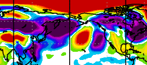
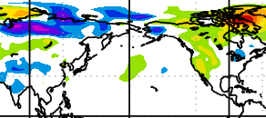
Most ensembles have cold in here by the weekend after Thanksgiving. EPS is slowest end of that weekend. Some AI versions have it by Black Friday. Weekly products have the cold pattern lasting 2-3 weeks now, a marked change from the quick hit shown last week. Strato situation is trying to reflect at 500 mb which is also a cold signal. MJO actually comes around about Dec 1st, but will then line up with other signals for cold. Check of the Physical Science Lab PSL Map Room: Global Circulation (Quick Menu): NOAA Physical Sciences Laboratory shows the table being set after we get past the warm North America (here late week, early next week). True Arctic surface press is quite high. Part of Siberia is getting cold north of the Kazakhstan warmth. Eventually we'll look for higher pressure into Siberia from the Arctic, and for it to get into more of Alaska. Note a small cold patch is already in western AK. 7-day surface press anomaly red is high 7-day temp anomaly blue is cold
-

2025-2026 ENSO
40/70 Benchmark replied to 40/70 Benchmark's topic in Weather Forecasting and Discussion
Yea, 2007 I had one 4" event before the second week, but 2008 was only a T prior. -

November 2025 general discussions and probable topic derailings ...
ineedsnow replied to Typhoon Tip's topic in New England
Had some flakes here.. I think its been 5 or 6 days in a row now -

2025-2026 ENSO
PhiEaglesfan712 replied to 40/70 Benchmark's topic in Weather Forecasting and Discussion
The first week of December in 2007 was the best of that month, in regards to cold and snow. The snowstorm on the 5th was the best event until February 22nd. Although, the previous month (November) was colder than average. 2008 got going in the 2nd half of November, with a snowstorm on November 20. Again, the previous month (October) was colder than average. Weird thing about this winter is that the cold and snow didn't really align. October-January was the cold part, but the big storm was on March 1-2 (that was the beginning of about 6-7 years of great storms). -
2025-2026 ENSO
40/70 Benchmark replied to 40/70 Benchmark's topic in Weather Forecasting and Discussion
Absolutely. A couple of my best months of December (2007 and 2008), which I incorporated into the Outlook as analogs, didn't get going until the second week. -
Despite my time on here, mostly for winters, I’m not well versed on SSWEs. Do they have any impact on the teleconnections at all? Or can they be entirely wasted with teleconnections being unfavorable? I can’t remember any ones from recent years to go look at, at least ones that have materialized.
-
I still wouldn’t give up on a net neutral NAO (between -0.25 and +0.25) DJF averaged out, especially because of the very weak SPV to start. Although solid +NAOs have been dominant recently other than 20-21 (near minimum), there was a net neutral NAO DJF during the weak SPV, -ENSO, active solar winters in 2000-1 and 2001-2.
- Today
-

Central PA Fall Discussions and Obs
mahantango#1 replied to ChescoWx's topic in Upstate New York/Pennsylvania
Yes it is, talked to several people and their sick of this wind. -
2025-2026 ENSO
brooklynwx99 replied to 40/70 Benchmark's topic in Weather Forecasting and Discussion
also, anything before Dec 10 is gravy for 80% of NE/MA posters on this board. couldn't care less if it takes a few more days to get things going -
 Oh my God that has to be saved and used repeatedly this winter
 -
2025-2026 ENSO
brooklynwx99 replied to 40/70 Benchmark's topic in Weather Forecasting and Discussion
models often rush the progression of cold air eastward in -EPO patterns. i would say after the 5th is when snow risks increase for many in the Northeast in the same vein, i don't think much has really changed in terms of the overall progression. MJO is moving along, the SPV will become very weak and increase the shot at a -NAO spell, and we should see a BN to solidly BN December also, when you have a -WPO/-EPO (and likely a -NAO at some point), it is really, really difficult to have a truly bad period since there's so much cold air displaced into Canada and the CONUS -
 I didn't @ him at least. That would be dangerous.
 -
November 2025 general discussions and probable topic derailings ...
WinterWolf replied to Typhoon Tip's topic in New England
Maybe for the heaviest…but I’d say mid December through mid March for good chances.


