All Activity
- Past hour
-
Exactly lol
-
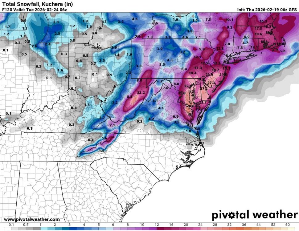
Snow has entered my forecast zone from MRX for the weekend.
-

Feb 22nd/23rd "There's no way..." Storm Thread
aldie 22 replied to Maestrobjwa's topic in Mid Atlantic
Ive stopped paying attention because all of the I-81 boys told me we are getting skunked out here. Congrats to eastern Loudoun -

“Cory’s in NYC! Let’s HECS!” Feb. 22-24 Disco
The 4 Seasons replied to TheSnowman's topic in New England
Looks like the whole cluster on the 6Z GEFS shifted NW -

E PA/NJ/DE Winter 2025-26 Obs/Discussion
Rnt1969 replied to LVblizzard's topic in Philadelphia Region
I agree the GFS is on another planet. I’m predicting by [emoji[emoji638][emoji639][emoji[emoji6[emoji640][emoji638]][emoji640][emoji640]][emoji[emoji6[emoji640][emoji638]][emoji640][emoji6[emoji640][emoji637]]]][emoji[emoji638][emoji639][emoji[emoji6[emoji640][emoji638]][emoji640][emoji6[emoji640][emoji637]]][emoji[emoji638][emoji639][emoji[emoji6[emoji640][emoji638]][emoji640][emoji640]][emoji[emoji6[emoji640][emoji638]][emoji640][emoji640]]]]z today it ends up in the camp with the EURO. . -

“Cory’s in NYC! Let’s HECS!” Feb. 22-24 Disco
Kitz Craver replied to TheSnowman's topic in New England
I believe that GFS when the EURO comes out soon. Beware of the off hour waffles. Mmmmm. Breakfast… -
“Cory’s in NYC! Let’s HECS!” Feb. 22-24 Disco
The 4 Seasons replied to TheSnowman's topic in New England
The Euro has been adamantly stubborn, so well see if it ever catches on, or we reach a middle ground somewhere SE of the BM that teases everyone. -

“Cory’s in NYC! Let’s HECS!” Feb. 22-24 Disco
CoastalWx replied to TheSnowman's topic in New England
Good to see euro ai on board at least. This whole setup still doesn’t sit comfortably with me though. Like we’re waiting for the rug to really get pulled. Hopefully 6z euro and euro ai on board. We don’t need massive bumps. -
Seems like the Euro and gfs flip flop on the flow snow but this morning's gfs run looks good. Sent from my SM-G998U using Tapatalk
-
“Cory’s in NYC! Let’s HECS!” Feb. 22-24 Disco
The 4 Seasons replied to TheSnowman's topic in New England
not happening james -

“Cory’s in NYC! Let’s HECS!” Feb. 22-24 Disco
ineedsnow replied to TheSnowman's topic in New England
Do it! -
“Cory’s in NYC! Let’s HECS!” Feb. 22-24 Disco
The 4 Seasons replied to TheSnowman's topic in New England
That was a very good run overall. Solid 30-40mi bump N/NW in the closed Low at 500. Looks like the GEFS should bump NW early on. The Machine was only a tick or so better, funny how far SE that went and were watching it correct back NW after it ran over HFD a couple days ago -
LOL at the differences on the GFS between 18z, 0z and now 6z regarding Monday's possible system. It's a hit for some again, probably a different at 12z
-
Because its hideous lol
-
What’s crazy is the things that fuel the storm and track are only 42 hours away Something has to give right?
-
“Cory’s in NYC! Let’s HECS!” Feb. 22-24 Disco
CoastalWx replied to TheSnowman's topic in New England
That’s a blizzard here -
Low-end warning snows on the 3k for up here.
-
Just looking at the 0z EPS panels- there is a definite increase in the number of members that have a significant coastal low close enough to the coast compared to 12z yesterday.
-
Thats one tick away from 30" from Washington to Boston. Too bad its an outlier and its probably smoking something.
-
It’s weird, the actual track sort of dances around. West, northwest, southwest, then northeast of the previous run but looks overall less squashed on the northwest side. Allowing better dynamics to back in, intact? Track is definitely better early on but isn’t a huge difference by the time it’s impacting us. But maybe, if it isn't getting elongated in an unfavorable direction could actually have the fabled west death band as it expands. Another way it could work out if the track stays a little too far away.
-
I’m surprised that miserable Will hadn’t posted the icon
-

Feb 22nd/23rd "There's no way..." Storm Thread
SomeguyfromTakomaPark replied to Maestrobjwa's topic in Mid Atlantic
6:30 am -

Feb 22nd/23rd "There's no way..." Storm Thread
Solution Man replied to Maestrobjwa's topic in Mid Atlantic
We wait -
The ens mean looks more sensible- has the most snow in the climo favored areas
-
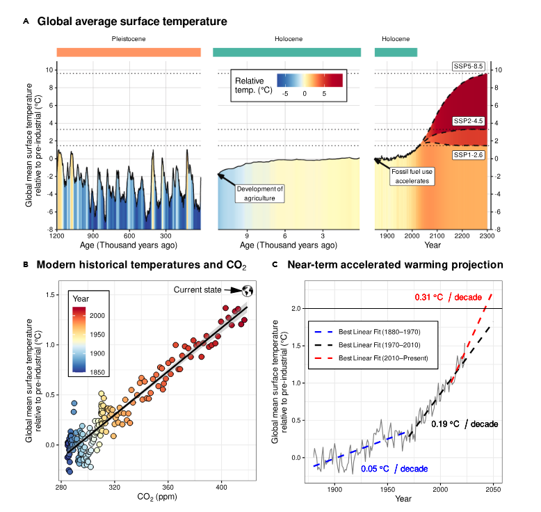
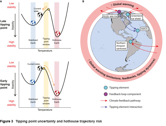
Recent paper has good discussion on: our climate trajectory, the tipping point concept, how close we are getting to tipping points, and the scientific uncertainty. https://www.cell.com/one-earth/fulltext/S2590-3322(25)00391-4