All Activity
- Past hour
-
Yeah...the threads that don't have COC vs torch in them **Spoiler Alert**
-
I vaguely remember seeing that somewhere too
-
I'm heading west to Yosemite tomorrow through Tuesday coming home to 8" of rain could be fun. GFS is probably right though
-
Basically. I actually saw some post recently saying GGEM now has highest verification scores!? But I think it’s gonna rain…
-
The largest/highest heat dome on the entire planet is centered over Tennessee according to Ryan Hall. We edged out the one over the Sahara Desert. I see forecasts calling for a cool down after next Tuesday. The 12z Euro came on board after the 0z was wall to wall warmth.
-
 http://menon36.com/# Cialis 20mg price
 -
things are so hot in the central USA that it's never cool. My place keeps getting 70 dew points. Go away. We want weather that's cooler. Less sweaty. The +6 degrees F in Amarillo Texas might be like the warmest 90 days ever.
-
I mean when it comes to which models I want on my side that’s basically a list from “hell no” to “great to have”
- Today
-
12z gfs does have a frost risk for far NW zones at day 12…
-
It has @EastCoast NPZ in the heavy rain totals... so we have to toss it
-

2026-2027 Record-breaking El Nino
GaWx replied to Stormchaserchuck1's topic in Weather Forecasting and Discussion
The E US heat of Sept 2026 is somewhat similar to the intense E US heat of another El Niño Sept, that of record breaking 1925. -
This looks nice:
-
Cialis 20mg price: Men On 36 - Cialis 20mg price in USA
-

Septorcher 2026 Discussion - Endless Summer
Typhoon Tip replied to Damage In Tolland's topic in New England
Joke ( or not ) aside ... something like 'weather modification' may be down the road of Quantum Computing. If and when the QC cores start actually understanding all the quantum states of a system simultaneously - largely purported to be how they 'quantum compute' - it doesn't intuitively seem like sending spin instructions/communicating to the matrix ( so to speak ) is a very big leap beyond that. We had a course work in 'chaos' in nature vs weather modeling in FAST II back in the headier university days up at UML. ...Jesus the dinosaurs were big back then... The principle idea was that weather modeling would one day hit a limit ... the speculation back then in the 1990s was that it would probably be between 5 and 7... beyond that, the permutation horizon was not readable, because it was based up emergence' that were yet to occur. That may still be true, yet ... won't matter. Because we don't have to know the future any longer. Philosophically, there's no need for the preparation if were programming the winds. In other words, conventional model become a thing of the past. What a weird state that would be. For those that are born in such an era, not so much. But if one remembers a time when "pita-flops" were required to multi-modal processing of navier-stokes at grid points... and the trillions in tech and satellite that went into it all ... paper weights. -
Buy Cialis online: MenOn 36 - Tadalafil price
-
12z guidance summary for Sunday-next week: 12z gfs ai: what rain? 12z gfs: sprinkles 12z GGEM: rainy 12z euro ai: very rainy 12z euro: deluge
-

Septorcher 2026 Discussion - Endless Summer
weatherwiz replied to Damage In Tolland's topic in New England
The potential is certainly there to be quite above average and this is the time of year (along with spring) where one needs to be extremely careful with using model 2M temperature output to forecast temperatures. I mean I don't think this is as big of an issue in our region but you look at the midwestern states this time of year and model 2M temps (and MOS) can bust 10-20F too low. Anyways, the look has the potential to be quite warm, however, I think there is going to be potential for more "blocky" or BDCF risk moving into the second half of the month. The other thing we're starting to see too is with stronger shortwaves coming down from Canada, that upper-level ridge which has been locked in since July is starting to get beat up. That GFS "cold blast" which DT was probably referring too I think is just typical extended range GFS overblown crap but we'll probably end up seasonal for temps...and maybe a bit below if we get the BDCF riddled pattern -
Even in the two Super El Ninos (1972-73 and 1997-98) that produced near shutout winters, it wasn't because of lack of opportunities. There were big storms, just elsewhere. January 1973 was one of the biggest daily snowfalls in Virginia Beach's history. Then February 1973 was one of the most greatest snowstorms in the Southeast. 1998 had one of the worst ice storms on record in New England and an all timer blizzard in Kentucky. Even interior areas of the Northeast managed to do well in some of the events that were all rain near I-95. It's not hard to see how those storms could become an I-95 hit instead if the deck is reshuffled. Pinpointing whether storms are a hit or miss comes down to storm track, which partially comes down to luck but more so based on large scale teleconnections that cannot be accurately pinpointed this far out. Either way, warm overall (dare I say torch) with a higher than usual chance of a KU seems like a reasonable call.
-
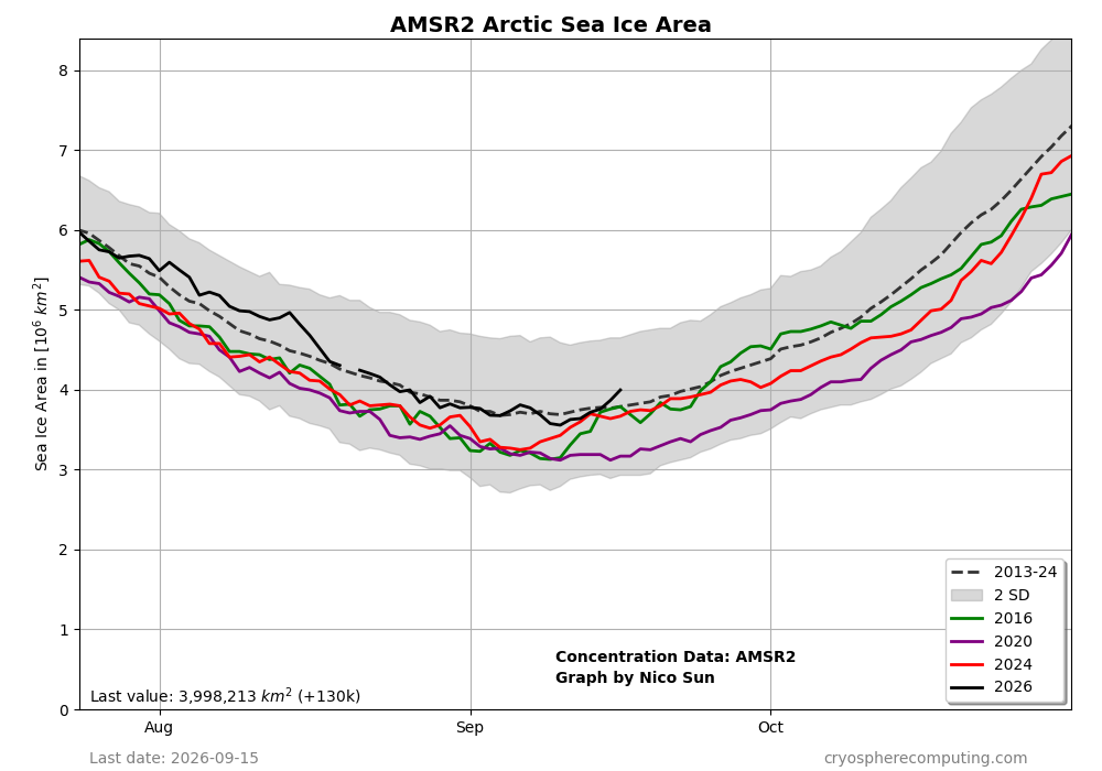
This chart agrees with your data that the minimum has passed due to increases during the last week: 2026 is now back to ~175K sq km above the 2013-24 avg for Sept 15th, which is the best in relation to that avg in about a month. It’s now per this chart >800K higher than it was on 9/15/2020! 2020 didn’t reach yesterday’s level til ~Oct 5th! The cold Arctic N of 80N during summer very likely helped:
-

Septorcher 2026 Discussion - Endless Summer
Ginx snewx replied to Damage In Tolland's topic in New England
I have weathernet3 data available on my ginxweather.com website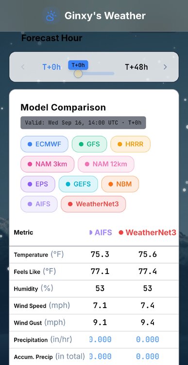
-
Is there an OT thread there where people can fight about who is stealing snow?
-

E PA/NJ/DE Autumn 2026 Obs/Discussion
RedSky replied to PhiEaglesfan712's topic in Philadelphia Region
Incredibly boring top 10 weather days -
Prob safe to call the extent min now too....about a 130k increase in the last two days as rapid refreezing is occurring in the high central arctic basin. So it looks like the final minimums this year will be 2.711 million sq km on NSIDC area and 4.574 million sqkm on NSIDC extent.
-
viagra canada: Get Belvion - Buy Viagra online cheap
-
Septorcher 2026 Discussion - Endless Summer
Typhoon Tip replied to Damage In Tolland's topic in New England
It's a torch in the other deep layer synoptic metrics ... just not at the surface. It's unusual to have 590 dm non-hydrostats and keep it less than 80 in an offshore flow. I've actually seem this sort of oddity with increasing frequency in recent years. Not sure if it's a Gretta or not but ... it's when non-hydrostats and even the hydrostatic heights (thickness) are elevated enough for very warm (relative to season...) yet the surface is some significantly blunted below the potential. The lower troposphere is oddly lagging behind the mid/upper air sounding. interesting